The "Peralta" Stone Maps --- On Their Own

Somero, imagine that you are weeks from a source of supplies - no dynamite , just at best black powder, - so you do what you can with available materiel's known to work at that time.

As for the laborers, no one ever gave them thoght except for their producing capacity.
u
Fire was an important tool in those days, both for cracking an rock, and for ''ventilation''..

Under these circumstances mining works were very limited. Of course, further south nearer Mexco city etc, where explosives and iron tools were readily available, they were impressive even by today's standards..

Don JOse de La Mancha.
 

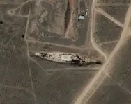
The photo attached is a good example of the dangers of GE interpretation. For many years, rumors circulated online that it was a full-sized mock of the Battleship Bismarck used for target practice in New Mexico. This rumor was only recently debunked and the site revealed to be actually a pit from which earth was taken to build a berm nearby to protect observers against RP backblast from rocket launcher tanks. In other words, a pit that just happened to be shaped like a battleship, with vegetation that just happened to be in the right place.


earth_battleship.jpg
 

Last edited:
Morning Don Jose coffee :coffee2:

I would agree that the closer to "civilization" the logistics and cost of large scale mining operations would be more viable, operations to the Superstitions may have been more limited early on. Maybe small exploratory groups at first, keeping your costs down. After finding any minerals worth mining then start sending in larger groups seasonally and hope the natives don't get to upset. The logistics of supporting such operations has to be considered when contemplating mining operations in an area so far from anything. I honestly think they were just small groups less than 30 in number finding small amounts of useful minerals, not enough to warrant large scale operations.

Interesting that no major towns were established close to the Superstitions, seems that if large scale mining were going on you would have some kind of town or presidio close by especially if that much wealth were being carted out as some have speculated. I think the limited wealth and the dangers of the natives may have kept the Mexican/Spanish from really putting any major effort into the area. It was not until the American prospectors moved in that any real attempts were made to bring control to the area and large scale operations began.

Tayopa had a town/mission close from what I understand.

Just some morning, drinking coffee, rambling speculation.
 

Last edited:
The photo attached is a good example of the dangers of GE interpretation. For many years, rumors circulated online that it was a full-sized mock of the Battleship Bismarck used for target practice in New Mexico. This rumor was only recently debunked and the site revealed to be actually a pit from which earth was taken to build a berm nearby to protect observers against RP backblast from rocket launcher tanks. In other words, a pit that just happened to be shaped like a battleship, with vegetation that just happened to be in the right place.


View attachment 936202

Hello !! ??? What is the matter with you ? This image don't look like a ship ? If somebody want to make an arrow shape from roks , trees , pit , etc . the shape don't change . Is stiil to look like an arrow . Or don't ? :BangHead:

PS

Another arrow shape from Ge . I don't care if is made from cotton flowers or whatever else .

Arrow.jpg
 

Last edited:
From the size of the Boulders and the angle of the hill, looks like G.E. flattened the formation. To me it looks like a sharp ridge with weathering at the base.

Thought I did a Thread on G.E. and the problems it has :dontknow:

Mother Nature meeting technology usually gets weird.

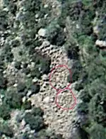
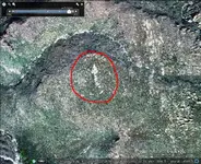
View attachment 935356View attachment 935357

Sure can see it, and gave my opinion about what it could be.


View attachment 936268

Marius

Can you see the crosses in this G.E. image?

Do they look man made?
 

Last edited:
Eric , are not man made . And I don't wrote how the arrow is man made . I wrote " What you believe about this arrow ? " . But I believe how those who wanted to make a sign , had choosen a boulder or whatever looks like this they wanted to make , and after made little changes to that . I believe would be very difficult to make a big sign from the beginning . A big sign which could be seen from afar .
 

Eric , are not man made . And I don't wrote how the arrow is man made . I wrote " What you believe about this arrow ? " . But I believe how those who wanted to make a sign , had choosen a boulder or whatever looks like this they wanted to make , and after made little changes to that . I believe would be very difficult to make a big sign from the beginning . A big sign which could be seen from afar .

I would agree with that, but please understand my concern and how G.E. can make natural formations distorted. The arrow you posted is on top of a hill, made up of a weathered rock formation and not really visible from a route of travel. If any trail markers are going to be visible it would be from a route of travel and most likely small since Mexican or Spanish groups traveling in the area did not have the manpower to create large monuments or enhance natural ones on that scale. You have to look at the Spanish/Mexican history of the southwest to see that they did not commit a lot of resources to the Superstitions. They just had to many problems with the natives and internal and external political issues with other nations to commit to the region. Only reason they moved into California as far as they did was to keep other European nations from grabbing it. So trying to control such a vast empty area with little wealth would be a waste of resources, IMHO.
 

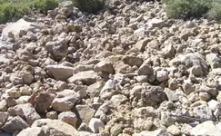
HPIM7241.JPG

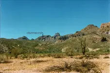
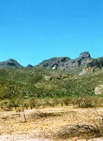
This is the real world picture of the G.E. image I posted. The large light colored boulder to the left in both images is a good reference point. Sorry no crosses found :dontknow:
 

View attachment 936311

This is the real world picture of the G.E. image I posted. The large light colored boulder to the left in both images is a good reference point. Sorry no crosses found :dontknow:

Howdy Somero,

That should be labeled Google Earth Fail. You're doing it wrong.:laughing7:

What the G.E. image showed was a cluster of white rocks without any vegetation, and that is exactly what you found.:icon_thumleft:

Homar
 

G'd afternoon Somero, where's mi coffee? As for the arrow Marius, it reminds me of the old navigation arrows for the early airmail service Pilots.

Don Jose de La Mancha

:coffee2: bit o tequila with that.

Surprisingly it points towards Payson directly East of A.J...............................:dontknow:
 

Last edited:
Howdy Somero,

That should be labeled Google Earth Fail. You're doing it wrong.:laughing7:

What the G.E. image showed was a cluster of white rocks without any vegetation, and that is exactly what you found.:icon_thumleft:

Homar

:laughing7: Took the picture couple years ago, then compared it to updated G.E. images just to see how good the resolution was.
 

Last edited:
Eric

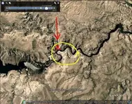
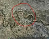
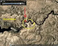
Just to play . The arrow points just west of Horse Mesa , and from the arrow to Salt River are 14 Km . Some people in the past have see some river courses like a horse head . Look to these two pictures for similarities . In the first is the Salt River in the place which shows the arrow , and in the second is the Horse Head Pass on Pecos River in Texas .

1.jpg Horse head.jpg
 

Marius:

Maybe this helps....

HM.png

Been there- Done that...8-)
Just like a couple of other folks.

But the guys who carved the stones weren't looking down from the heavens.
 

Last edited:
10-4 Somehiker,

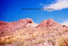
Arrow as viewed from the south side of the Gila River looking north. Notice the number three (3) on the left upper corner of the arrowhead itself, not the shaft. The architects were very clever when designing these shadow signs. If you do not recognize the 3 hidden in the arrowhead you loose, that is why this arrow can only be observed in the AM (see comments below).

Arrow@heart text.jpg Arrow-heart_resize.jpg Notice text upper-center-right-side-edge of "far left" photograph. I included a close up of the arrow.

Standing near actual location of arrow.

eye-catcher_arrow.jpg

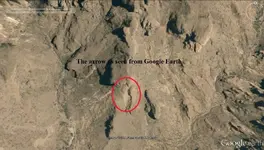
Arrow as seen from Google Earth.

Google Arrow and numbers txt.jpg

The arrow was designed to be seen from a flat level plane. The numbers (upper right) were meant to be viewed from a nearby highly elevated peak. However, you can still see the numbers somewhat in this image.

Somehiker is correct; these carved/enhanced signs/symbols were designed and located on an exact-chosen position on the surface of the earth. The viewing corridor was also specified by the architect of the structure. You must be located within the correct path of sight. The difficulty arises when trying to determine the correct time of year, days and time frame (AM,PM, etc.).

Shadow Signs 101,

Ellie B
 

Last edited:
...
I would agree that the closer to "civilization" the logistics and cost of large scale mining operations would be more viable, operations to the Superstitions may have been more limited early on. Maybe small exploratory groups at first, keeping your costs down. After finding any minerals worth mining then start sending in larger groups seasonally and hope the natives don't get to upset. The logistics of supporting such operations has to be considered when contemplating mining operations in an area so far from anything. I honestly think they were just small groups less than 30 in number finding small amounts of useful minerals, not enough to warrant large scale operations.

Interesting that no major towns were established close to the Superstitions, seems that if large scale mining were going on you would have some kind of town or presidio close by especially if that much wealth were being carted out as some have speculated. I think the limited wealth and the dangers of the natives may have kept the Mexican/Spanish from really putting any major effort into the area. It was not until the American prospectors moved in that any real attempts were made to bring control to the area and large scale operations began ...

Quite right. The bosses and the miners had to eat every day. They needed forage for the stock. They needed water and shelter. Where did all these necessities come from, and how were they maintained over time? Where are the ruins of their camps? Where are the specific oral traditions from the natives living in the Gila and Santa Cruz valleys, who certainly would have been well aware of significant Mexican work details in the 1840's?

I agree with you - Mexican mining in the Southwest was generally seasonal and very limited in scope. Placer mining, which required much easier logistics, was the primary focus, of course. It's low-tech and requires less skilled labor. Lode mining required finding a surface outcrop of visible gold in a free-milling country rock, often iron-stained nearby, and often in quartz. These oxidized-zone types of deposits could be rich, but frequently played out early or changed into complex ores with depth, where they would have been abandoned. There would have been fairly shallow workings left behind, 'coyote holes' - what would be called 'prospects' today. In a low-mineralized area, there might not be many of these.
 

EB:

If you had been out there yesterday, you could have shown all of that to Tom K. and had his opinion as well.
Not sure if he has studied "Shadow Signs 101", but I know I haven't. Don't really think I lose out by not seeing a three in your arrow, since I've already seen some of what's at the end of the rainbow. I imagine it could have been seen by anyone, any time of the day or year for that matter. Just had to be standing somewhere out front, and not too far away. No digging required, since mother nature had intervened on my behalf I guess. Patience has it's rewards.

But all this talk of "architects" and precise viewing parameters sounds kind of interesting.
Who were these "architects" and how many hours/days/months (seasons) and years did they expect someone to spend in following their cleverly convoluted system of "signs" and trails ? Is that answer somewhere in the codes ?

Regards:SH.
 

Last edited:
Hello !! ??? What is the matter with you ? This image don't look like a ship ? If somebody want to make an arrow shape from roks , trees , pit , etc . the shape don't change . Is stiil to look like an arrow . Or don't ? :BangHead:

Marius, if you reread what I wrote, you'll note that I never said anything about the ship-shaped geological feature in the photo I posted. I only mentioned that it was rumored to be a mock of a ship (for target practice) when in reality it was simply a pit. That is the folly of trying to interpret GE images.

As far as the stone maps go, I am of the opinion that looking for clues in GE images is completely useless.
 

Last edited:

Top Member Reactions

Users who are viewing this thread

Back
Top