tayopa, legend or reality ...?

HI, to clarify, they do "not" publish tax delinquency lists, just property that has reverted to the Gov't for one reason or another. Then, after a period which may be from a few months to several years, the property is again listed as free for denouncing., specifying the hr. and date that they will be free for filing, perhaps 1 -2 months prior to becoming free.. They are listed in the Diario Offical in Mexico city as they come due.

Incidentally, all legal mining contracts are listed there also. These lists are carefully checked daily by Mining engr's etc.

Don Jose de La Mancha
 

Thank you very much amigo, I hope you will keep an eye out for the specific property just in case a bit of neglect on the current owner's part should occur.
Oroblanco
 

I second that Ed - good luck and I hope you have some great photos to show us when you get back
 

HOLA amigos,

Ed T wrote
It would be nice to hear some more of your wisdom Real.

and Don Jose de la Mancha wrote
A deal gentlemen

Well hmm? We are waiting patiently amigos, hope you will find the time to post some of that hard-earned wisdom soon. (This goes for you too Ed, and Arkhunter, and Pegleglooker, and CJ, Djui, Gollum, Old Dog, and you know whom else - I hope you will all share some of your wisdom and experiences?) Thank you in advance, & sign me PATIENT, :icon_thumleft:
Oroblanco
 

Don Jose de la Mancha:

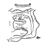
After viewing the map you have posted in this thread, a light went on in my memory and upon looking through some graphics on file I pulled this one up. I understand that the Utes used to steal herds of horses as they traveled to the South in large raids on the new settlements. Sometimes with as many as 1,000 braves. They would travel North on the return up through The Devil's Pass out of San Bernardino and then back into the Wasatch Mountains. The Natives became rich and feared by their kind through these Spanish steeds.
I believe this map came from a collection gathered from "Archivo de Madrid" Spanish Commission - West Indies.
 

Attachments

  • Minas del Yutas.jpg
    Minas del Yutas.jpg
    114.4 KB · Views: 664
Good morning my friends: Twisted fork, your map is correct. It is basically the same as the one that Dobie posted in his book "Apache Gold, Yaqui Silver. The names, of course, are dif., but the nacimiento del Arroyo Caudalosa is more correct than Dobies'..

Go to post #905 above to 'Paramo' for a picture of the nacimiento of this Arroyo Caudalosa.. The view is looking south. The mesa of Tayopa lies to the right.

I thank you for an excellent addition to my library on Tayopa.

Don Jose de La Mancha

p.s. Nacimiento = start or birthplace.

p.p.s. Stop wheezing ORO.
 

Twisted fork: On your map, the upper trail "Camino del Osos", trail of the Bear, is quite correct. It does pass between "Oso de arriba and Oso de abajo', The place of the bear on top, and the place of the bear below", they are now abandoned ranches. I particularly liked this bit of data as further confirmation.

Both still have excellent orchards, apples, peaches, plums, etc. The apples are of the small tart ones , delicious. I generally eat so many in Oct., that I have a permanent seat in the outhouse, still eating them. sigh..

Don Jose de La Mancha
 

I suspect there is a marker sequence code in it that comes into view by cutting the map into several pieces and then reassembling through a system of overlays. Will have to try this one, it appears to be he same technique. Fun Stuff............
 

Real de Tayopa wrote
p.p.s. Stop wheezing ORO

Do I have to stop drooling too? Sheesh! :o ::) :tongue3: Next you will be telling me to stop dragging my knuckles! :notworthy:

Twisted Fork, LOVE that map! :icon_thumleft:
Oroblanco
:coffee2: :coffee2:
 

Top Member Reactions

Users who are viewing this thread

Latest Discussions

Back
Top