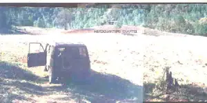
The reason I ask is that I just got done reading his book and also looking at the plates in the Scribners magazine article, after looking at your pictures and then reading his discription of his journey, one could almost imagine that you had traveled to that area together, of course I know not even you are that old

This part in paticular.
An ocean of mountains spread out before and below us. In the midst
of it, right in front of us, were imposing pine-clad mesas and two
weathered pinnacles of reddish conglomerate, while further on there
followed range after range, peak after peak; the most distant ones,
toward the south, seeming at least as far as eighty miles away. The
course of the rivers, as they flow deep down between the mountains,
was pointed out to us. The principal one is the Arros River, which
from the west embraces most of the mesas, and then, turning south,
receives its tributaries, the Tutuhuaca and the Mulatos, the latter
just behind a pinnacle. West of the Arros River stretches out the
immense Mesa de los Apaches, once a stronghold of these marauders,
reaching as far as the Rio Bonito. The plateau is also called "The
Devil's Spine Mesa," after a high and very narrow ridge, which rises
conspicuously from the mesa's western edge and runs in a northerly
and southerly direction, like the edge of a gigantic saw. To our
amazement, the guide here indicated to us where the camino real from
Nacori passes east over a gap in the "Devil's Spine" ridge, and then
over several sharp buttes that descend toward the mesa. An odd-looking
mesa lay between Rio Bonito and Rio Satachi. Farthest to the west
were the big hogbacks near Nacori, standing out ominously, like a
perpetuated flash of lightning. The sun was nearing the horizon; the
air was translucent, and the entire panorama steeped in a dusky blue.
Immediately below us, to our left, lay Guaynopa. The mountainside
looked so steep that it seemed impossible for us to descend from
where we were. But we already heard the voices of our muleteers
singing out to the animals 1,000 feet below, and that reminded us
that we also had better reach camp before darkness should overtake
us. We descended 2,500 feet, and, leaving the pines behind, found
ourselves in a warmer climate. It never snows here, according to our
guide. That the precipitation took the shape of rain we learned when
we were impeded by it for two days.
There were yet eighteen miles between us and the deserted
mines of Guaynopa. It was a laborious journey over the hills,
mostly ascent. Finally we came to a steep slope covered with oaks,
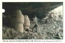
along which there was a continuous descent toward Guaynopa. While
zigzagging our way down, we caught sight of a large cave with houses
and some white cone-shaped structures staring at us across an arroyo
midway up the opposite side, which was at least two thousand feet
deep. Through my field glasses I could make out very distinctly a
group of houses of the usual pattern; and the large, white structures
could without difficulty be recognised as granaries, similar to those
observed in Cave Valley. It was my intention to go back and examine
this cave more closely, as soon as I had found a camping place; but
circumstances interfered. Several years later the cave was visited
by Mr. G. P. Ramsey, to whom I owe the following brief description.
The cave is situated about twenty-five miles in a straight line south
of the Mormon colony of Chuhuichupa. There are indications of a spring
in the cave, and there is another one in the arroyo itself. The
buildings are in a very bad condition, owing to the action of the
elements and animals; but fifty-three rooms could be counted. They were
located on a rocky terrace extending from the extreme right to the
rear centre of the cave. This extreme right extended slightly beyond
the overhanging cliff, and contained groups of two-storied houses. In
the central part of the cave were a number of small structures, built
of the same material and in a similar manner as those I described
as granaries in Cave Valley. They were still in excellent condition,
and, as will be seen at a glance, they are almost identical with the
granaries used to the present day in some southern States of Mexico.
We continued our descent, and, having dropped altogether some 2,000
feet, at last found ourselves alongside some lonely and unattractive
old adobe houses. They were built by the Spaniards and are reputed
to have once been the smelter of the now abandoned silver mine of
Guaynopa. Only the naked walls remain standing on a decline, which
was too steep to give us sufficient camping ground. So we went still a
little further, to the top of a hill near by, where we made a tolerably
good camp.
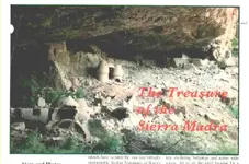
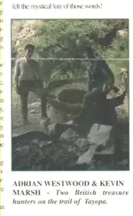
This then was the famous locality of Guaynopa, credited with hiding
such fabulous wealth. There was still another mine here of the same
repute, called Tayopa, and both of them are said to have been worked
once by the Jesuits, who before their expulsion from Mexico were
in possession of nearly all the mines in the country. According to
tradition, the Apaches killed everybody here, and the mines were
forgotten until recent times, when ancient church records and other
Spanish documents revealed their existence. Several expeditions have
been sent out, one, I believe, by the Government for the purpose of
locating them; but being situated in the roughest and most inaccessible
part of the Sierra Madre, they are still awaiting their rediscovery,
unless, contrary to my knowledge, they have been found in recent
years. There is no doubt that the country carries very rich silver
ore, and we ourselves found specimens of that kind; but the region
is so difficult of access that it probably would require too great
a capital to work the mines.
There was now a plain track leading along the hillside down toward
the Rio Aros, which is scarcely two miles off; but the country was so
wild and rugged that the greatest care had to be exercised with the
animals to prevent them from coming to grief. The path runs along the
upper part of a steep slope, which from a perpendicular weathered cliff
drops some 400 feet down into a gorge. As the declivity of the slope
is about forty-five degrees, and the track in some places only about
a foot wide, there is no saving it if an animal loses its foothold,
or if its pack slips. All went well, however, until we reached a point
where the track commenced to descend, when our villain of a guide tried
to drive some burros back on the track, instead of leading each one
carefully. The result was that one of the poor beasts tumbled down,
making immense bounds, a hundred feet at a time, and, of course,
was killed.
We had no difficulty in fording the Guaynopa Creek near its junction
with the Aros River, and selected a camping place on a terrace 200 feet
above it. The stream, which is the one that passes the cave-dwellings,
carries a good deal of limpid water, and there are abundant signs
that at times it runs very high. The elevation of the ford, which
is here about the same as that of Aros River, 3,400 feet, was the
lowest point we reached in our crossing of the Sierra Madre between
Chuhuichupa and Temosachic. It took us almost the entire day to move
the animals the one mile and a half to this camp. On the way we had
found some good quartz crystals in the baryte, about four inches high
and one inch in width.
The country before us looked more forbidding than ever, as if it
did not want us to penetrate any further into its mysteries, but our
guide seemed to be quite at home here.
Our march toward Rio Chico was about thirty miles of ups and downs,
ascending to a height of 7,600 feet and descending again some 3,000
feet. In the beginning it was almost impossible to make out the track;
where it did not lead over bare rocks, it was nearly obliterated
by overgrown grass. The first ascent was over a mile long in a
straight line; then, after a little while, came the most arduous
climbing I had until then ever attempted. Following the slope of the
mountain, the track rose higher and higher in long zigzags, without
any chance for the animals to rest, for at least three-quarters of
a mile. It was necessary to push them on, as otherwise the train
would unavoidably have upset, and one or the other have rolled down
the declivity. One large white mule, El Chino, after it had almost
climbed to the top, turned giddy at the "glory-crowned height" it
had reached, and, sinking on its hind legs, fell backward and rolled
heels over head down, with its two large canvas-covered boxes, like
a big wheel. As luck would have it, it bumped against a low-stemmed
old oak that cropped out of the hillside in an obtuse angle to it,
some ninety feet below. Making one more turn up the stem, the mule was
nicely caught between the forked branches, which broke the momentum,
loosened the cargo, and caused the animal to fall back into the high
grass. One box landed close by, the other, containing our library,
pursued its course downward 200 feet further, bursting open on the
way and scattering the wisdom of the ages to the winds, while the
mule escaped without a scratch.
The burros came into camp three hours after us, and the drivers
explained how they had succeeded in bringing them up the long slope
only by constantly punching them to prevent them from "falling asleep."
As we continued our journey toward Rio Chico the panorama of the
sierra changed continuously. We got a side view of the big Mesa de
los Apaches, and many weathered pinnacles of eroded conglomerate were
seen standing out like church spires in this desert of rock, varying
in colour from red to lead gray. Once we caught sight of a stretch of
the Rio Aros deep down in a narrow, desolate valley, some 3,000 feet
below us. The geological formation of the region is mostly volcanic;
then follows conglomerate, and on the high points porphyry appears.
We camped on the crest of the eastern side of the Rio Chico Canon,
in an ideal place with bracing air. A fine, sloping meadow afforded
quite an arcadian view with the animals peacefully grazing and resting;
but looking westward, the eye revelled in the grand panorama of the
sierra. The two sides of the Rio Chico Valley rise here evenly from
the bottom of the gorge so as to suggest the letter V. In many places
its brow is overhung by precipitous cliffs, and further down still
more steeply walled chasms yawn up from the river bed.