Stone Tablets-Most likely planted fakes.

If I haven't learned anything else from my years researching the Lost Dutchman Mine and the Stone Maps, I have learned that whenever someone thinks they have a new take on either, or they have come up with a new idea. If you look long and hard enough, you will find that someone else has had that exact same idea before! HAHAHA

The difference in your outcome versus someone else's that had the same idea as you is ALL in the execution! Lots and lots of armchair treasure hunters that know beyond a shadow of a doubt that they are the ones with the correct interpretation of the stones, or one of the many maps. Nothing will convince them otherwise. Yet every time one of them actually does put boots on the ground, they find someone else's footprints on the spot they figured out. BlindBowman was a perfect example. He found the LDM via Google Earth. Everybody told him he was nuts. He argued over and over that he was right. Everybody that knew the area he posted about knew that Chuck Crawford had claims there a looooong time ago. When BB finally showed up and hiked to his spot, he found he was wrong. He admitted as much and ate a good chunk of Humble Pie.

There are a lot of people that have spent a lot of years searching for and researching this subject.

Mike

I tend to believe sgt/Frank when he says the old rt 60 due to the news article that shows the horse head map tracing. It also shows an old beat up bridge where the stone was found.

With all of your researcb you dont know where the old rt60 is? Or where the stone was found?
 

Correct me if i'm wrong, as I have only visited the area and don't live there, but how often, and how severe does Queen Creek flood? I doubt that anyone would deliberately bury these sandstone tablets near a creek that could flood and ruin or alter them to the point of being unreadable. I imagine the water table and possibly the creek's route were different back then. I know the location sits up aways from the creek on a small bluff, but is it far enough away from the creek to insure this won't happen?

The bluff sits above the creek by a good amount, but at that location the QC basin is pretty wide so it wouldn't have mattered.
 

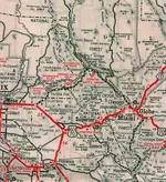
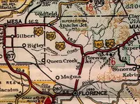
From Arizona road maps
1935 and 1938

1935-4 AZ.jpg Az 1938.png 1935-4 AZcr.png

Looks like the highway was re-routed and the #80 became #60 sometime between 1935 (left and right side enlargement) and 1938 (map in center).
At that time, the bluff was cut down for the newer part and the roadway graded to provide a gradual slope down to the new two lane bridge.
This IMO, is why the H/P Stone became partly exposed so that T. Tumlinson could see some of the carving upon it.
 

Last edited:
....
 

Attachments

  • 1424842284604.jpg
    1424842284604.jpg
    137.1 KB · Views: 105
  • 1424842299399.jpg
    1424842299399.jpg
    148.1 KB · Views: 105
I have studied the Stone Maps as much or more than anybody. I spent months investigating them and their trail from 1949 until present. There is a LOT that I know that I have posted. There is still a bit I found that I haven't made statements about. It has nothing to do with their authenticity, but rather possible solutions.

You are also falling into the trap
Nope. I make no claim as to any relevance or authenticity. So far I think they are a crock/fraud :D
set by many earlier folks that tied them in with the Peralta or Gonzalez Family. There is absolutely NOTHING concrete that ties them to either of those families. Also, I don't think that they have anything at all to do with the LDM. CHLSBRNS and I do agree on one thing: They have to do with hidden caches not mines. CHLSBRNS, maybe if you visited the area, you might understand that there are no caches there. Actually though, you are basically thinking like Robert Tumlinson (Travis' Uncle). It was his theory that there were caches near the beginning of the 18 point trail, not in the mountains. To be honest, the next time I visited the area after Jim sent me that map, I wandered around the area with one of my Fisher Gemini Two-Box Detectors. HAHAHA NADA!


Mike
 

Mr.Gollum, I used to have a map of the Southwest when the Jesuits thought they were running the show. That map
showed plenty of small way stations and water holes, and very small 1 room missions all connected to the same road.
It is possible and not out of the realm of reality that there was a small mission where Tummilson found the map stone.
Again if so, just maybe the Indians there were tasked with makeing the map stones and heart stone to be hidden
for future use. There is a bridge and there is water, so a good place for humans. Maybe the renagade Apaches destroyed it.
 

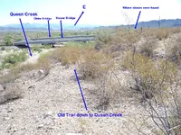
Here's a shot of the Highway bridges over Queen Creek, taken from the old trail about 1/4 mile to the west.
It's easy to see how much higher the area where Tumlinson dug up the stones is, than the bed of Queen Creek.
The west bound lanes (to Phoenix) utilize the older of the two bridges.


100_1536 QC.png
 

Last edited:
Hi Some Hiker,

I have a Map that shows the area the Stones were found is next to a small mountain just to the west of that bridge. I looked in that area around the bridge but did not find the Cactus with the carved thumb pointing to the Maps. Only Cactus like that was where the Map said it was at a campsite next to the that small mountain. I'm looking for the Map in my Archives. Haven't found it yet I'll post when I do.

I believe the Priest and Horse Map is the Final Map and the other map's long range symbolism is coded in Solar Time.
Of course I never make my Beliefs based on pure speculation, it's from actual experience.


I'm not old to look but you know my hiking stick may let her down!
 

Last edited:
I tend to believe sgt/Frank when he says the old rt 60 due to the news article that shows the horse head map tracing. It also shows an old beat up bridge where the stone was found.

With all of your researcb you dont know where the old rt60 is? Or where the stone was found?

Why would you write this? He makes an effort to help you and you belittle him?
 

Did you read it? Is it worth buying?

I read the article yes, but IMHO it is not really worth buying as Azmula doesn't reveal the source behind his theory that the Stones were originally found at the Nuestra Señora de la Asunción in Arizpe. Until he does, or I find independent confirmation, I will continue to consider that theory a speculation.
 

Father Charles Polzer SJ was a Jesuit Priest whose main lot in life was to ensure that Father Eusebio Kino SJ was Canonized. He was a very good man that NEVER saw ANYTHING relating to Jesuit Wealth that was authentic (in his opinion). Maybe a little conflict of interest?

Also in 1986, Polzer heard that Tayopa had been found. He and a friend flew to Mexico and attempted to claim it for the Church (after years of saying the Jesuits owned no mines and they were a poor Order). He was so obnoxious about it, the Mexicans forced him off the site. His luggage was lost on the trip home.

Father Polzer would not have been able to tell a hand carved stone map from a machine carved stone map. He did not have either the experience nor education for it. I have more experience than Father Polzer in examining stone monuments, symbols, and artifacts. I was allowed to examine the Stone Maps with a digital microscope in 2010. I had them all in a dark room, and used several types of lighting along with a digital microscope. I found no traces of metal in the grooves, and ABSOLUTELY NOTHING that would tell me they were in any way modern. Here are a couple of pics in case you don't believe me:

View attachment 1122814 View attachment 1122816 View attachment 1122815

Just a couple of over 4 gigabytes of hi-resolution pictures. Here is one of the digital scope pics of the "B" in CABOLLO on the Horse/Priest Stone:

View attachment 1122817

The people I know that worked at the AZ Mining and Minerals Museum told me that nobody knew for certain. That there were many stories floating around about them.

Anybody is free to believe anything and anybody they choose. When I speak, its mostly not from what I have been told by someone, I mostly speak from personal knowledge of a subject.

Mike
Well done ! Much more interesting than reading a bunch of garbage posted by self proclaimed experts who's entire effort at "research" has been done while sitting in a chair... :thumbsup:
 

Why would you write this? He makes an effort to help you and you belittle him?

I wrote it because it is my opinion!

Help me what? Try to convince me that the stones are not fake is not helping me.

Belittle? Sorry but it's hard for me to believe someone who thinks that sworn affidavits of multiple third party hearsay statements from decades ago that also include absurd statements of absurd assays are proof of anything.
 

Hello hunters,
I’ve followed this site for more than a year. Didn’t make the effort to join until today. As I have little to add to the wonderful base of knowledge here, I didn’t see it necessary. No disrespect meant, I just didn’t have anything of value to share. I do appreciate all that has been shared for me to read.
As my user name reflects I’m far too old to consider hiking the Superstitions. Would, that I could. I’m no threat to anyone’s stake in the hunt.
I have enjoyed the Legends show and look forward to further episodes. Putting faces and voices with the names is definitely a plus. The personalities are just as I suspected and add much to the entertainment value.
As to the drama, its television entertainment. I take it or leave it for what it is. Its entertainment not a history class. Nuggets of history mixed in, but sorting them out is what makes it interesting.
The scenery is spectacular. I have, in years past, traveled the Southwest. It’s a magical place. Nothing like it anywhere else. Until you have seen it with your own eyes you never really understand or appreciate the words of the song……purple mountain’s majesty……. It’s breathtaking.
There are a couple things I would like to comment on. Thus, my reason for logging in.
As to the horse of the Santa Fe. As has been noted, not only can one find documentation of the horse head imposed on a topo map, you can actually see it for yourself. Not only the head, but the entire outline of the horse can be traced, quite easily, in available on-line satellite aerials. The horse depicted on the stone maps, with it nuisances, ear set, stance, etc. is quite visible with little effort. Also viewable (be it a little more difficult) is the counter interpretation of the elephant. I make no correlation of being able to outline the drawing and its authenticity as a treasure map. That’s up to one’s own research and beliefs. All I’m saying is……….its there.
What I do find very compelling (at least in my mind) is that its in the right area. Based on the clues that “I” consider factual, Waltz area of interest was the south-southeast flank of the Superstitions. Its relationship and distance to Florence Junction places it in the right part of the territory. Still no small area to hunt but narrows the field, at least for my interest.
 

Top Member Reactions

Users who are viewing this thread

Back
Top