Stone Charts of the Superstitions

Status
Not open for further replies.
cactusjumper said:
Wayne,

I don't know the particulars of this specific claim, so I don't have any idea when it was filed. I do know there was no claim when the original pictures I have posted were taken. That would be back in the mid-sixties.

I can assure you that was "back in the day". In that period I know that Black Top Mesa had claims being filed all over the place. They had no ore of value. What they said they had, or what evidence they produced is another matter. :evil5:

I have never been to the markings down in the Twin Buttes area, so I'm not the person to answer all your questions. From what you have written, I assume you have been there, so you're one up on me.
In this case, I have to rely on others for my information. :lurk:

Take care,

Joe

Joe:

I believe you misunderstood.I was not trying to say that the claim involved mineral ore,but I see little reason for the trouble and expense of fencing and a bulldozer unless some discovery was made or at least strongly suspected.Your assumption that I have seen the hill first hand is mistaken.As I stated earlier in this thread,I was told where it is,given a map showing the location, and shown a series of photographs of the hill and markings from several locations.This occurred at the Rendezvous and the photos were taken,including some of the ruins and some from the air,last spring.Shortly after that,you and I had a brief discussion about the markings,as you may recall.
I didn't have a chance in the week following the Rendezvous to get out there,but I have spent some time researching the area and it's history since then and will hike out and get my own photos,perhaps this spring.Maybe then will I be one-up on ya..... ::)
I do not have contact info for this person,but I have left a message with my G-mail info on another board (aviation) which we use,asking him for copies of some of the photos and permission to post.If he responds and agrees,I will post them here.

Regards:Wayne
 

Hi Hal,

i would say yes the sun Jose mentions is visible on GE or at least 3/4 of it but not on the latest version, but can be seen using GE 5 or 5.1 it is to the east of the river and slightly north of the turn into the Tayopa complex, Jose will correct me on that if I'm wrong, as I'm now on GE 6,
so it is from memory,
the latest version uses diffrent satelite imagery and the area appears to have been overgrown so can't be seen on GE 6

also anyone using GE needs to set the elevation exageration in tools to 1 point 5 as it is set at 1 to make it easier for flyovers and not correct !

John
 

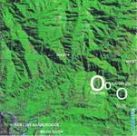
Gentlemen LADIES: :coffee2: :coffee2: :coffee2: :coffee2: Hal, Furness, Here is an older Sat view of the zone with the basic points shown.


The precise lat & Long of the Tayopa 'Monument' is ---->

Latitude - 28* 00' 26.1560" North Y= 3 099,530.320

Long. 108* 56' 57.8662 West


Don Jose de La Mancha
 

Attachments

  • Map of the Tayopa SUN zone ©@.jpg
    Map of the Tayopa SUN zone ©@.jpg
    53.7 KB · Views: 1,251
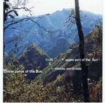
Due to a request by pm, I am posting a corrected photo of the Sun. This is to clarify it, it is the furthest series of brush, small trees below the vertical arrow.. You can easily se the upper and lower curvatures of the circle.

Don Jose de La Mancha
 

Attachments

  • Side view of the sun  pp2 ©@.jpg
    Side view of the sun pp2 ©@.jpg
    46.8 KB · Views: 1,650
Real de Tayopa Tropical Tramp,
The coordinates to your symbol don't seem to match the imagery that you have posted. However I was able to locate something that looks like the symbol you describe at the following location: 27 59'2.41"N 108 49'57.07"W This symbol is found on your greenish satellite image, right next to your corresponding marked location. It appears to be a Sun Wheel Symbol with the interior "+" aligned to the four directions. Please let me know if this is what you are writing about or perhaps it is just an anomaly. :tard: One BIG question you could help me with is who do you think constructed the symbol? Thank you again for sharing. Also, if this is the location... notice what appears to be another symbol just below your Sun Wheel... perhaps a monogram for "Christ"??????? There is one similar to this in the Superstitions.


furness,
Thank you for the GE tip!

Somehiker,
Excellent links to the articles. Thank you for posting that. I will make an effort to photograph the Twin Butte symbols in the spring and will post what I find here. I have not identifies the site yet but I am working on it. Would you share your thoughts on who you believe made them?
 

Hal:
I don't have it handy,but there was a professional report published online some time ago regarding the scrapings.
Samples taken from ironwood post-dating the removal of overburden...the opinion being that the ironwood took root sometime after the scrapings were completed...were dated at 300 yrs of age approx.There was testing of other categories of samples as well,but I cannot recall the particulars.
A date range of around 300 years,combined with the symbolism,narrows the field as to who.
Probably early colonial Spanish.
Other than that..... :dontknow:

I'm still only part way into consolidating and organizing my research files.
If I can find the report,and it's not copyrighted, I will post it.

Still waiting for an answer on the photos I asked for last week.
But he hasn't posted for a couple of months,so it might take awhile.

Regards:SH.
 

Wayne,

You may be thinking of this post by Tracy Hawkins over on the LDM Forum:
__________________________________________________________

Tracy L Hawkins Post subject: Posted: Thu Jan 30, 2003 11:51 am


Part Timer

Joined: Wed Oct 09, 2002 5:39 pm
Posts: 67
Location: Phoenix Az Joe
The people I talked to ( Ernie and I ) were from Northern Az Univ. in Flagstaff. We ran into them on the second or third trip Ernie had made there so it was in the mid 60's. At that time they were taking samples of the ironwood trees growing through the scraping to ringdate . I heard later that some of them were 350 years old, that would put them about at the time of the first Jesuits being in the area as you suggested. I may have been overlooking an importint clue all these years.
TH

PS
Joe

Has anyone ask for copys of the pictures you have ?
TH
___________________________________________

As I recall, I called NAU and they could find nothing to confirm what Tracy said. If I did, I would have posted that information somewhere on the Forum.

Take care,

Joe

On looking a bit more, this was my last post on the topic:
________________________________________________

Joe Ribaudo Post subject: Lucky Seven?Posted: Fri Feb 07, 2003 11:35 am


Expert

Joined: Tue Sep 17, 2002 10:36 pm
Posts: 5019 S.C.,

At the risk of looking like I am paying more attention to what others say than is necessary, Tracy has already addressed the Twin Buttes Seven subject.
The seven is actually a curved arrow pointing to the center of the heart. If that seems familiar, you have been paying, at least, some attention to the Stone Maps. The picture in Bob Ward's book, is of the Twin Buttes Markings.
I have been in touch with three department directors at N.A.U. They have been unable to find any reference to the mid-sixties work at Twin Buttes.
The Professor I am waiting to hear from may have some information for us. If not, I will see if they would be interested in dating the Ironwood now.
The seven on the photographic plates might be denoting the location of gold. Then again, it could be a reference to the "Seven guns on Black Top"
mentioned in The Killer Mountains, which, by coincidence, was my uncle's team.

Joe
 

Joe:
I really can't recall who collected the samples,did the testing and prepared the reports.I do recall some considerable expense being mentioned in the file for proper testing,so it may have been an NGO effort done with non university funding. Archeological society or museum sponsored maybe.
Neither ASU or NAU ring a bell and I also think late 70's or early 80's to be the time frame.Problem is,I had little interest in Stone Maps until more recently and came across the report while researching the pre-columbian history and ruins of the area.I do not recall the report even mentioning the Stone Maps (I didn't even have a file dedicated to Stone Maps myself at the time) ,but can't be sure until I find it again.
I often save many files and links for later reference while surfing for information.Likely I did with this one.....just can't remember where,or what the name was.
edit:here's an example of one just found and saved....http://quarriesandbeyond.org/states/az/az-quarry_photo.html
and another....http://www.examiner.com/cryptozoology-1-in-mesa/mitchell-waite
I'll keep looking,though.

Regards:Wayne
 

Wayne,

Mitch Waite was a partner of mine. We exchanged a lot of information. He had figured out the Stone Maps and led many trips into the mountains. We met online and then got together in Goldfield. Sat down for lunch, and I gave him an unmarked topographic map and a yellow marker.

With a copy of the trail maps next to the topo', I told him where to start drawing....at the bottom of Hieroglyphic Canyon. After ten minuets or so, he simply said, "When do we go in".

As for the NAU testing down at Twin Buttes, I am simply going on what Tracy Hawkins said. I will give Ernie Provence a call and see if he can provide more details.

Take care,

Joe
 

Good afternoon Hal: In regards to the Sun, the 'Jesuits definitely' made it by simply removing the over burden. This was their Holy Grail of precious metals.

Since they had lost the actual location of Tayopa, they certainly did not want to lose the other in the event of another Indian uprising and they had to leave for a few years. It still serves it's purpose nicely.

The other point that you asked about --> "notice what appears to be another symbol just below your Sun Wheel... perhaps a monogram for Christ".
****************

I believe that it just an uneven growth of the brush / small trees inside of the Sun. Perhaps with more reflective characteristics. Go back to the latest side view post of the Sun to verify if this is what you are referring to. Jan. 08.

Don Jose de La Mancha
 

Joe:
Not doubting your reflections on what you were told.It's quite possible that without the documents at hand,my own memory is at fault.
NAU has done a great deal of work on archaeological sites all over Arizona,as well as studying the many intaglos and petroglyph sites which dot the maps of the SW.
It would make sense that they had done so with the TB scrapings as well and hopefully Tracy will be able to add more information.

Although Mitch's name is familiar to me,as is his face,his writing is not.I do see that he has written some articles about the Stone Maps though,and will read them later this evening.

I'm sure the stories of his own searches ,as well a your joint efforts as partners will make for an interesting read.He is still quite actively seeking and writing,as this link shows....http://www.examiner.com/user-gold527 . I will have to check for updates from time to time.I assume he has attended the Rendezvous ?

Regards:Wayne
 

Hal,

I have no problem with anyone posting any of my pictures. Any time you post someone else's pictures, the original photographer should be given credit.

Take care,

Joe
 

cactusjumper,
Thank you for that. I am still searching for the TW scraping but these images are helping... I think.
"Original picture(s) came from Chuck Ribaudo. I believe it may have been taken by Tracy Hawkins. Posted by Joe Ribaudo on Wed 12 Jul 2006 01:06:39 AM EDT"


Hal:

I see the linked page has been removed since I made the post.
It did work ok when I checked it from the post,which I always do.
Mitch sells his newsletters in e-book form,so he may have removed it for that reason.
Here is one that still works,and has much of the same info and U-Tube video links.
http://twitter.com/MitchWaite1
Try this one again as well.
http://www.examiner.com/user-gold527
 

I am trying to find any information on the Lost Dutchman Society... it's history, the people involved, and the current status. Any help or direction would be appreciated.
 

cactusjumper,
I already have that page bookmarked. It is something to think about, however I am looking for a more historical account of the LDS. It is surprising that so little is available regarding this group. In all the time that you have spent researching the Superstitions, did you ever look into the LDS or meet someone associated with the organization? Do you remember me asking you about the history of Queen Valley? Anyway, thanks again for sharing.
 

Cubfan64,
You used the word "tale" to describe the story that Joe has posted a link to. Besides the obvious incorrect dating of events, what is it that makes this story so unbelievable to you? I am assuming your use of the word "tale" to describe this story means that you don't give it much credence. If that is correct, I will tell you that while the story may seem less then believable, there is a great deal of evidence to suggest that an important part of that story is actually correct.

The answer to the question "just who done it?" is the treasure. This story or tale is worth considering.

On another note, I remember reading that you recently paid a visit to the Tumlinson site (where the stone were reported to be found). Could you tell me if Weavers Needle is visible from that location? Your help is appreciated.
 

Status
Not open for further replies.

Top Member Reactions

Users who are viewing this thread

Back
Top