Status On TAYOPA

Shortfinger or Oro-
One way or another, I'll definitely keep everyone posted. To answer your question Shortfinger, though I've yet to look on an actual map to get an idea of the areas you speak of, I can tell you it was in a heavily wooded area (though, that's probably describing ALL of Maine), just South of the tiny town of Oquossoc, on the otherside of Route 17 from Rangeley Lake, and at the bottom of a "smaller" sized mountain called Bald Mt. This is all on the opposite side of the lake from the actual town of Rangeley as well as Saddleback Mountain which, to my knowledge, besides being a popular ski resort in the winter, is also the last mountain on the Appalachain trail. Bald Mountain sits between Rangeley Lake and Lake Mooselookmeguntic where we'd camp for a night each time we would vacation there. We stayed at a "resort" called Mountain View Cottages and they consisted of 5 very rustic cabins; the type where your heat was the fireplace and you'd better not forget that "if it's yellow, let it mellow" or you'd be dealing with a nasty septic issue!

Hope this helps. I'm going to research it a bit more this weekend. My aunt & uncle fell in love with the place and built their own home down from where we stayed so I could definitely head out there to "hunt" for a minute relatively cheaply (besides gas & food). I'll let ya'll know any updates.

All the best-
Justin

Side thing: while staying there, we would get FRESH Maine lobsters directly off the truck that had only been out of the water however long it took to get from the coast inland to about 45 minutes from the border of New Hampshire. My father and uncle would spend the entire day, drinking scotch & smoking stogies, waiting for water in a massive black pot (4' diameter x 3' tall) to boil before putting the lobster in......at that time, they cost $2.65 PER POUND!
 

Shortfinger wrote


My use of that term "shoe fitting" was in relation to trying to fit something that doesn't. As with, for example, we have people trying to tell us that Montezuma's tomb is in the Superstition mountains, which while possible is not very likely. Perhaps "shoe horning" or "funnel vision" would have been a better simile. I would suggest taking another look at a map of Mexico, noting the location of Tayopa and the location where most have searched for El Naranjal, as well as the finding of the camino real sign. It is a sizable distance apart. But by all means, DO go find that mine Don Jose is calling El Naranjal, heck it could set you up for life financially! :treasurechest: $$$

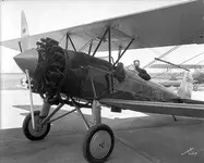
I could not recall the name of the plane, but a quick search using the names of the airmen turned up an interesting site:
Introduction

Clearly that group Tighar is interested as you suggested, and propeller hub is the correct term. I hope that Justin will keep us posted when he returns to that area in Maine.

Please do continue,
:coffee2: :coffee2:
Well, maybe you are correct. Or not. As has been stated many times, if a mine is lost, it is hard to determine exactly where it is. And, the camino real sign is currently in the lost category now, no? Although Don Jose’s location is not in the traditional location, nothing has been found so far in the traditional location either, so….If it looks like a duck and quacks like a duck…As far as being set for life, Don Jose already has a claim on the area, so I don’t expect anything but the adventure ( :2barsgold: and perhaps one or two small souvenirs :2barsgold: ) out of the expedition. I expect that I will be able to last out my life pretty well with what I have, if I don’t waste all my money chasing after lost treasures….Maybe I better rethink this. :tongue3:

As far as the plane goes, there are (or have been) several groups and individuals interested in the possible crash site. NUMA (Clive Cussler’s group) did some searches in the 1980’s as well, with no results.

White Bird | National Underwater and Marine Agency

Hopefully Justin will keep us posted. Whatever it is, it is definitely worth a closer look.

:coffee2::coffee2:
 

Ok all. As far as I can tell, the name of the piece I saw in the woods is called the Spinner- the piece that prop slides onto at the front of the engine. The pic below will give you an idea, though the picture shows one much bigger than what I saw though still identical in overall look

. ImageUploadedByTreasureNet.com1435348224.148907.jpg
ImageUploadedByTreasureNet.com1435348241.362492.jpg

As usual, all the best.
Justin

PS I'm sorry if this is bothering anyone to be discussing a non-Tayopa topic in the Tayopa thread. My apologies of course.
 

Shortfinger or Oro-
One way or another, I'll definitely keep everyone posted. To answer your question Shortfinger, though I've yet to look on an actual map to get an idea of the areas you speak of, I can tell you it was in a heavily wooded area (though, that's probably describing ALL of Maine), just South of the tiny town of Oquossoc, on the otherside of Route 17 from Rangeley Lake, and at the bottom of a "smaller" sized mountain called Bald Mt. This is all on the opposite side of the lake from the actual town of Rangeley as well as Saddleback Mountain which, to my knowledge, besides being a popular ski resort in the winter, is also the last mountain on the Appalachain trail. Bald Mountain sits between Rangeley Lake and Lake Mooselookmeguntic where we'd camp for a night each time we would vacation there. We stayed at a "resort" called Mountain View Cottages and they consisted of 5 very rustic cabins; the type where your heat was the fireplace and you'd better not forget that "if it's yellow, let it mellow" or you'd be dealing with a nasty septic issue!

Hope this helps. I'm going to research it a bit more this weekend. My aunt & uncle fell in love with the place and built their own home down from where we stayed so I could definitely head out there to "hunt" for a minute relatively cheaply (besides gas & food). I'll let ya'll know any updates.

All the best-
Justin

Side thing: while staying there, we would get FRESH Maine lobsters directly off the truck that had only been out of the water however long it took to get from the coast inland to about 45 minutes from the border of New Hampshire. My father and uncle would spend the entire day, drinking scotch & smoking stogies, waiting for water in a massive black pot (4' diameter x 3' tall) to boil before putting the lobster in......at that time, they cost $2.65 PER POUND!

Well, I must confess I haven't looked on a map either, but I seem to remember that there was some mention of Bald Mountain in one of the documented searches I read about. I actually researched this particular legend a little about a year ago, but maybe my memory isn't that good. I sure don't remember exactly why I was looking into it.

On your side note, I visited Maine twice, once in 1973 during a change of station leave in the Navy, and once in 2001, with my wife and kids. In 1973, I bought lobster at a dockside restaurant in Bar Harbor and had what I considered a feast (lobster and beer was all they had on the menu, who needs more). 28 years later, the same restaurant was there, and I had the same feast. It cost a little more, but was still very reasonable!

JB
 

Ok all. As far as I can tell, the name of the piece I saw in the woods is called the Spinner- the piece that prop slides onto at the front of the engine.

Well, we might be better off in the Miscellaneous Adventures thread, as Don Jose asked for campfire tales about treasure hunting, and some folks (myself included) went a little far afield there. But, usually, the moderators are pretty loose about this kind of thing on this thread anyway. As far as the spinner goes (which is the conical piece over the propeller hub, the second photo doesn't have a spinner, the hub is exposed), the photos I have seen of L’Oiseau don’t show a spinner. However it is still worth checking out.

JB
 

Regarding off topic, no adventure is off topic. I consider it on topic. Keep it up.

The missing clue is / was the size. The spinner would be the first thing knocked off in the case of forced landing in a heavily forested area

I left various pieces behind on my clipping that spruce tree

jpgbooboo.jpg~c100.jpg So you are an old swabbie eh SF.
 

Last edited:
RDT
C'mon,..It's time for some more stories and pictures of Tayopa,
I'm ready for the pictures that show the inside of the complex.
-Weekender
Mike

Agreed! Aaahem Don Jose! If nothing new on the current state of Tayopa, how bout the past? Any Tayopa related adventures that you've yet to share with us?

Health, happiness, and (golden) prosperity to all-
JA
 

Well, maybe you are correct. Or not. As has been stated many times, if a mine is lost, it is hard to determine exactly where it is. And, the camino real sign is currently in the lost category now, no? Although Don Jose’s location is not in the traditional location, nothing has been found so far in the traditional location either, so….If it looks like a duck and quacks like a duck…As far as being set for life, Don Jose already has a claim on the area, so I don’t expect anything but the adventure ( :2barsgold: and perhaps one or two small souvenirs :2barsgold: ) out of the expedition. I expect that I will be able to last out my life pretty well with what I have, if I don’t waste all my money chasing after lost treasures….Maybe I better rethink this. :tongue3:

As far as the plane goes, there are (or have been) several groups and individuals interested in the possible crash site. NUMA (Clive Cussler’s group) did some searches in the 1980’s as well, with no results.

White Bird | National Underwater and Marine Agency

Hopefully Justin will keep us posted. Whatever it is, it is definitely worth a closer look.

:coffee2::coffee2:

OK so if I say the mine is not at Tayopa you disagree, and if I say go for it, you disagree. So go for it, or don't go for it. Will that work for ya?

Amen on Tayopa - more please! :notworthy: :notworthy: :notworthy: :thumbsup:

:coffee2: :coffee2:
 

Guys & Gals, I was forced to form a company on Tayopa - financial reasons = as a result I had to give up certain rights, icluding how to run it, so I let them play after have given them most of th information, but they seem to be trying to second guess me. They have been playing around with the main deposit with lack of success, it is constructed almost like The Cabalos and victorio peak.

They seem to be expecting a magic door to appear for them but don't investigate the natural voids for an entrance.They hve reached the end of the trail but still no door, naturally, the entrance is before the end of the trail.:laughing7:

But it was this or forget Tayopa.

The same goes for the entrance to Tayopa itself. I have told them what to look for - but.

So in the meantime,I, like you , just wait on the side lines., but for me it is even more frustrating since I know the answers already, but I
need the pictures for you.
 

Last edited:
El tramp-
You need to get yourself one of those new state-of-the-art long range drones. Then you can just sit back, put a controller in your hands, and watch/direct the progress of Tayopa! That way, you'll always know what's going on, what the days progress is, and what the next step should be.

Just a thought.
A cuppa Joe for ya-
Justin
 

Real, Amigo
Heres your :coffee2::coffee2::coffee2:,Instead,couldn't you use a floppy eared old Mule equipped with same gear,:dontknow:np:cat:
 

OK so if I say the mine is not at Tayopa you disagree, and if I say go for it, you disagree. So go for it, or don't go for it. Will that work for ya?

Amen on Tayopa - more please! :notworthy: :notworthy: :notworthy: :thumbsup:

:coffee2: :coffee2:

Not saying I won't go for it (with permission and assistance from Don Jose, of course). Just saying that I will need to do some planning....But it all works for me.

:coffee2::coffee2::icon_scratch::coffee2::coffee2:

JB
 

Top Member Reactions

Users who are viewing this thread

Latest Discussions

Back
Top