Oak Island the Strange, the Bizarre, and Maybe the "Truth!

Freemason's "Wealth"?...Top Ten in the World!

What wealth?

Freemason's symbol.jpg

The 10 Richest Religions in the World - TheRichest

"Some people believe that Freemasonry is actually the richest organization in the world. Its members are said to be powerful and their symbol even appears on the dollar bill and the seal of the United States. Masonic lodges can be found all over the world."

Their great wealth may have come from "Oak Island" or from an awful lot of "Bake Sales"!

I believe that Oak Island holds the "Keys" to unlock the "Door" and reveal the "Truth" to "The (Untold) Story of the Oak Island Money Pit".
 

Is the show gonna be back ??

Definitely! As soon as Winter is over on Oak Island, the Lagina Brothers will be searching for more clues and evidence on the island.
 

View attachment 1278164

The 10 Richest Religions in the World - TheRichest

"Some people believe that Freemasonry is actually the richest organization in the world. Its members are said to be powerful and their symbol even appears on the dollar bill and the seal of the United States. Masonic lodges can be found all over the world."

Their great wealth may have come from "Oak Island" or from an awful lot of "Bake Sales"!

I believe that Oak Island holds the "Keys" to unlock the "Door" and reveal the "Truth" to "The (Untold) Story of the Oak Island Money Pit".

The American revolution was funded on a shoestring budget. American citizens were still trying to get what was owed to them decades later. If Joseph Martin is to be believed, they received firearms and little else. I'm honestly surprised that more of them didn't desert. They must have really believed in what they were fighting for. (And if one evaluates the Declaration of Independence against the era in which it was written, one will truly understand just how revolutionary and downright insane this was. Against that backdrop, I can see a guy giving up several years of earnings and fighting what was probably the world's best army at the time while trying not to starve or freeze to death.)

Freemasons were once a very wealthy organization. Go to your local lodge when they're open and see how well they're doing now. (They won't ask you to join because they're not allowed to, but they'll probably hint that they'd like you to join. They'll want money if you decide to do so.) If they had money at one point, it's gone. If they had money during the American Revolution, they certainly didn't spend it on that. If they did, it wasn't as much money as you think it might be.
 

Was the Capture of Havana in 1762... Just a “Ruse” by the Freemasons?

Did the "Freemasons" with the aid of their counterparts the "Jesuits" capture Havana from the Spanish Crown as a “Ruse” to plunder the Catholic Church’s secret hoard of "Inca Treasures from Tumbes Peru"?

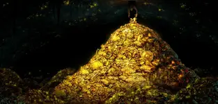
Inca Treasure.jpg

Along with the Spanish Crown, the Catholic Church was very much involved with the plundering of the Inca Empire.

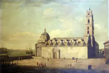
It would stand to reason that the Catholic Church unknown to the Spanish Crown, had a location to store its great wealth, and it was the Cathedral of Havana built by the Jesuits where they stored it.

Cathedral_at_Havana,_August-September_1762.jpg

In the 1700’s the Jesuits were becoming more entrenched with the Freemasons and were falling out of favor with Spain, who shortly expelled them in 1767.

The Jesuits informed the Freemasons of this vast Inca Treasure stored in the Cathedral of Havana and it was of no coincidence that Commander in Chief George Keppel’s first priority was to secure the Cathedral of Havana.

This vast treasure unknown to both the British Crown and the Spanish Crown was then transported back to Oak Island.
 

Pirate...The Buzzard...Olivier LeVasseur?

While researching author "gjb" and his "Treasure Net" thread..."An Oak Island Reconstruction", I came across information about the Pirate... Olivier LeVasseur.

"gjb" had an earlier time reference for a Colonel Jean LeVasseur and considered his connection to Oliver Levasseur.

"gjb" also writes about his research on 3 Triangles located at Oak Island.

This and other coincidences lead me to believe that the man known as La Buse...The Buzzard... may have a connection to "The Treasure of Oak Island"!
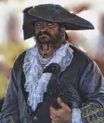
Buzzard.jpg

"Olivier LeVasseur (1688 or 1690 — 7 July 1730), was from a wealthy French family and very educated, he became the pirate nicknamed La Buse (The Buzzard), called thus because of the speed and ruthlessness with which he always attacked his enemies.
He is also known for allegedly hiding one of the biggest treasures in pirate history, estimated at over ÂŁ1 billion, and leaving a cryptogram behind with its whereabouts."

LeVasseur had "Pirated" the coast of Oak Island from Newfoundland to New England in the early 1700's.
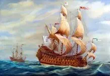
Nossa Senhora do Cabo.jpg

"LeVasseur captured the Portuguese great galleon Nossa Senhora do Cabo (Our Lady of the Cape), loaded full of treasures belonging to the Bishop of Goa, also called thePatriarch of the East Indies, and the Viceroy of Portugal, who were both on board returning home to Lisbon. The pirates were able to board the vessel without firing a single broadside because the Cabo had been damaged in a storm and to avoid capsizing the crew had dumped all of its 72 cannon overboard, then anchored off RĂ©union island to undergo repairs."

"The booty consisted of bars of gold and silver, dozens of boxes full of golden Guineas, diamonds, pearls, silk, art and religious objects from the Se Cathedral in Goa, including the Flaming Cross of Goa made of pure gold, inlaid with diamonds, rubies and emeralds. It was so heavy, that it required 3 men to carry it over to LeVasseur's ship."

After this plunder, LaVasseur refused the King's pardon as the condition required him to return his treasure.
The Buzzard..."was captured near Fort Dauphin, Madagascar and then taken to Saint-Denis, RĂ©union and hanged for piracy at 5 p.m. on 7 July 1730."

Legend tells that when he stood on the scaffold he had a necklace around his neck, containing a cryptogram of 17 lines, and threw this in the crowd while exclaiming:
"Find my treasure, the one who may understand it!"
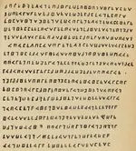
cryptogram-la-buse-gf.jpg

Olivier Levasseur was a Freemason and used the Freemason's Script for his Cryptogram.
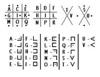
Alphabet_de_la_buse (1).jpg

In 1947 Englishman Reginald Cruise-Wilkins found three cryptograms compiled in mysterious alphabet, a rebus, or at least in initiatory writing which could be put in relation to masonic symbolism and the Clavicles of Solomon

Some of Cruise-Wilkins translation:

"The treasure chamber is somewhere underground and must be approached carefully, to avoid being inundated. It is protected by the tides, which require damming to hold them back, and is to be approached from the north. Access is through a stairwell cut into the rocks, and tunnels leading under the beach."


Cruise-Wilkins stated...."Something weird stunned me: how come that in The Buzzard's cryptogram, we only find three pointy "A" when all the others are squared?"

cryptogram-la-buse-3a Triangles.jpg

It has been stated for the location of the island...Look for the three large piles of rocks that each form a Triangle

"Cruise-Wilkins compares and convinces himself that the "A" in the text are the same as on the rock. On the rock, the "A" forms a triangle. And Bibique as a trigonometry amateur is then convinced that we just need to trace a bissector in the right way to find the location of the treasure. Except that we first need to find the original location of the stone!"

"And why would a pirate go to all that trouble to hide a treasure that no one was trying to steal"?

"It's amazing what these guys did... the passion, Cruise-Wilkins marvels. And after all, what else did a semi-retired pirate have to do"?
 

Last edited:
Robot

I’ve seen mention of the Seychelles treasure elsewhere on the forum, so maybe here’s not the place to pursue it. Just note that you’ve picked up on a few coincidences. There’s no saying that Jean Levasseur was responsible for the Oak Island venture, and no guarantee Olivier Levasseur was responsible for that on Mahe.

Hi gjb

This thread was started by "me" and I like to post unusual stories here as this site is tied into the internet and receives a lot of views!
 

27 Important!... Freemason's Marker Stones?

Why would any Treasure Map refer to instructions showing how many steps from a tree or marker stone were needed to locate their treasure?

Here in Canada, lightning and other causes can wipe out Marker Trees and Marker Stones may be moved and relocated, making it illogical and possibly invalid for any Map to be based solely on these reference points.

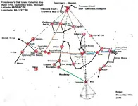
With more information supplied... I believe the Freemason’s Celestial Map will always show where their Marker Stones were located, showing the location to their Treasure Vault and Bacon’s Tomb.

Freemason's Celestial Map with Tunnels 2.jpg
 

Last edited:
Hmm, I thought the first watches (wearable) were from around the early 1500's. Would something like that along with an Astrolab give you a pretty decent placement?

One thing I've come to find, the older generations, going even way way back tended to be a lot smarter then the current generations. Look at the Egyptians, or the Mayans or Aztecs. We're still trying to come to terms with their knowledge. These "heathens"were masters of the stars, mathematics, and building, compared to say we folks now. As for the Masons, whether involved or not, they were the top of the hill so to say, in their trade. You don't just toss up a building or dig a tunnel without a survey of the area, and construction of such involves skills to keep it in place.


My thought only, but the money pit, if it did exist, is long gone. Retrieved by those responsible or their folks chosen to do so later.
It's called the money pit now because of all the money spent digging up the ground, looking for what is long gone. As stated, markers can be moved or destroyed.
Maybe those who originally placed them, moved or placed them after the fact, to misinform others seeking it. Heck all you would need is one little secret, using the markers, that someone without it would be unable to locate said place. Just a simple bearing change unknown to others could lead those in the know to a spot miles away from another. 3 stones in a triangle, pick one point to split the other two by ----- degrees, and bingo there's your spot. Meanwhile everyone else is scratching their heads trying to figure out what the triangle means.:coffee2::coffee2::coffee2:One for me, one for you, and one for those who follow.
 

Last edited:
I believe the Freemason’s Celestial Map will always show where their Marker Stones were located, showing the location to their Treasure Vault and Bacon’s Tomb.

I’m really sorry to interrupt, but I find I need to get back to basics here. I’m familiar with this star map, though I see it at different times of the year (about now, but not important). You could maybe clarify a couple of points.

First, the Lat.Long you give doesn’t seem to be Oak Island, which I’ve generally taken to be effectively N 44 31' (northerly point), W 64 18' (easterly point). I’ve not specifically Googled the location, because I can imagine it to be slightly northwest of Chester. I don’t suppose it makes much difference, but from where is the star map taken?

Second, I’ve got a problem with the date. I’ve used two astronomy packages to go back in time, and I don’t get this configuration on either program at the time stated. At midnight on 22 September, 1762, I have Lynx on the horizon. I take it the important fact is to have Polaris and Kochab aligning north-south at the autumn equinox. As I see it, this doesn’t happen until about six and a half hours later. Could you let me know your source for the timing?

Third, and not particularly important in a completely abstract way, Bootes is mostly below the horizon at this time. I also can’t figure out which star in the constellation is i Bootis. I take it this would be west of Arcturus, but these seem to be chi, omicron, pi and zeta. Can you help?

Fourth, I'm not convinced that Alioth and Mizar point into Bootes, but Mizar and Alkaid probably would. Could you give me some guidance on this?

I'm sure you must have been asked these questions before by interested parties here, and I hope I’m not out of order by raising points of interest concerning your blog.
 

Robot

I worked out myself where i Bootis had to be by following the line through Eltanin and Rastaban. My constellation guide only goes as far as lambda Bootis. The star is so faint it doesn’t show up well.
 

Freemason's Celestial Stones..."Carved in Stone"...and awaiting "Tested by Fire"!

Beautiful illustration Robot, . but was their knowledge of Celestial navigation that faradvanced in that period ? They were still using Astrolabs with no time keeping abilities.

The problem with a "Private Island" is the availability to test one's "Theory"!

I hope in the near future that this problem may be remedied.

The completion of Oak Island in 1762 was started with the plans and construction of the below listed men but made possible by the inventions brought forth through The Royal Society of London.

Visionary...Francis Bacon, 1st Viscount St Alban 22 January 1561 – 9 April 1626) was an English philosopher, statesman, scientist, jurist, orator, and author. He was extremely influential through his works, especially as philosophical advocate and practitioner of the scientific method during the scientific revolution.

Planner...Sir Isaac Newton (25 December 1642 – 20 March 1726/27) was an English physicist and mathematician (described in his own day as a "natural philosopher") who is widely recognized as one of the most influential scientists of all time and a key figure in the scientific revolution

Architect...Benjamin Franklin (January 17, 1706 – April 17, 1790) was one of the Founding Fathers of the United States. A renowned polymath, Franklin was a leading author, printer, political theorist, politician, Freemason, postmaster, scientist, inventor, civic activist, statesman, and diplomat. As a scientist, he was a major figure in the American Enlightenment and the history of physics for his discoveries and theories regarding electricity. As an inventor, he is known for the lightning rod, bifocals, and the Franklin stove, among other inventions.

Builders...
Admiral of the Fleet George Anson, 1st Baron Anson, (23 April 1697 – 6 June 1762)
Vice Admiral Washington Shirley, 5th Earl Ferrers, (26 May 1722 – 1 October 1778) was a British Royal Navy officer, peer, Freemason and amateur astronomer.
General George Keppel, 3rd Earl of Albemarle (London, 8 April 1724 – 13 October 1772), was a British soldier and nobleman.

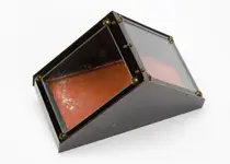
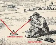
Mercury Trough and The Artificial Horizon:

George Adams (c. 1709–1773) was an English instrument maker and science writer. Inventor of the Mercury Tray with glass cover, inventor of the Artificial Horizon early 18th Century

artificial-horizon.jpg

artificial_horizon22.jpg

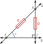
It was used on land in conjunction with a sextant to obtain celestial sightings when no sea level horizon was visible. By viewing the sun or a star directly in the reflection of the mercury surface, one would measure twice the angular altitude of the body above the horizontal (and then divide by two).

Trigonometry.png

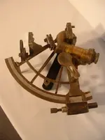
Sextant:

John Bird (1709-1776) Mathematical Instrument-Maker Functioning Mid 18th Century Sextant

Sextant 18th Century.jpg

Longitudinal Watch:

Alexander Cumming (1733 –8 March 1814) was a Scottish watchmaker and instrument inventor, who was the first to patent a design of the flush toilet.
and
John Harrison 1693– 24 March 1776) was a self-educated English carpenter and clock maker who invented the marine chronometer, a long-sought after device for solving the problem of calculating longitude while at sea. proceeded to design and make the world's first successful marine timekeeper that allowed a navigator to accurately assess his ship's position in longitude. Importantly, Harrison showed everyone that it could be done by using a watch to calculate longitude.[12] This was to be Harrison's masterpiece – an instrument of beauty, resembling an oversize pocket watch from the period. It is engraved with Harrison's signature, marked Number 1 and dated AD 1759.

Sea Wtch No 1. (H4).jpg
 

The Freemason's Star Map as viewed through...Stellarium.org

I’m really sorry to interrupt, but I find I need to get back to basics here. I’m familiar with this star map, though I see it at different times of the year (about now, but not important). You could maybe clarify a couple of points.

First, the Lat.Long you give doesn’t seem to be Oak Island, which I’ve generally taken to be effectively N 44 31' (northerly point), W 64 18' (easterly point). I’ve not specifically Googled the location, because I can imagine it to be slightly northwest of Chester. I don’t suppose it makes much difference, but from where is the star map taken?

Second, I’ve got a problem with the date. I’ve used two astronomy packages to go back in time, and I don’t get this configuration on either program at the time stated. At midnight on 22 September, 1762, I have Lynx on the horizon. I take it the important fact is to have Polaris and Kochab aligning north-south at the autumn equinox. As I see it, this doesn’t happen until about six and a half hours later. Could you let me know your source for the timing?

Third, and not particularly important in a completely abstract way, Bootes is mostly below the horizon at this time. I also can’t figure out which star in the constellation is i Bootis. I take it this would be west of Arcturus, but these seem to be chi, omicron, pi and zeta. Can you help?

Fourth, I'm not convinced that Alioth and Mizar point into Bootes, but Mizar and Alkaid probably would. Could you give me some guidance on this?

I'm sure you must have been asked these questions before by interested parties here, and I hope I’m not out of order by raising points of interest concerning your blog.


Hi gjb

No problem with questions...I always quote..."A wise man asks questions to learn"

I will try to answer.

The Lat.Long... I derived from the Google Map supplied by Forum Member Charlie P. (NY) post # 5 on this thread.

https://www.google.com/maps/place/4...3159846,7392m/data=!3m1!1e3!4m2!3m1!1s0x0:0x0

My logic (I believe you also stated) was that the Welling Triangle may be the Apex Point from where the Originators commenced their operation and design.

From my computation, I presumed the Triangle to be located at:
Latitude: 44deg30'45.00"
Longitude: 64deg17'21.00"

The "Free" software program you will need is "Stellarium". Stellarium

First...Download

Second...Open Left Side Bar

(1st) Location Window:
Enter:
Lat: N44deg30'45.00"
Long: W64deg17'21.00"
Altitude: 0m
Name: Oak Island
Country: Canada
Planet: Earth

(2nd) Date/Time Window:
Set:
Year..1762..note the 2 remains so add 176 prior to it to obtain 1762
Month...9
Day...22
Hour...0
Minute...0
Second...0

Third...Open Left Bottom Bar

Click each of these icons to insure they are lighted:

(1st) Constellation Lines
(2nd) Constellation Labels
(6th) Ground
(7th) Cardinal Points

Now spin the sky around so you are facing (N) North

Zoom in or out and Click on the Star (iBoo) located just above where the lines from the Stars (Alioth and Mizar) and (Eltanin and Rastaban) would transect. This Transection is the real point where the Triangle would have been placed.
Use iBoo as the Triangle and place it at the very bottom of the chart with a Perpendicular line running straight up through (Stone 1) Kochab and Polaris.

You should now be viewing the Sky as the Freemasons did in 1762 when they placed each of these Celestial Star Markers as Terrestrial Stone Markers pointing to their location for the Treasure Vault and Burial Tomb.
 

Last edited:
Gentle men, I must have missed something, but I thought we were talking about a 1500 date (carbon dating ot the coconut fibres and the wood? In the 1500's they did 'not' have sextants nor accurate time pieces. The best that I could do 1n 1944 on celestial positioning was about 100 meters with a pocket chronometer and a sextant (aerial)..

For accurate longitude you must have an accurate time piece with a KNOWN gain or loss. I am no talking bout GPS, which is fantastic.

So forgive me if I ask where the 1700's came in?:coffee2::coffee2::coffee2: I haven't been monitoring this forum as I should.

We used a pool of Mercury to establish a true earth's surface (vertical) for our Nordan bombsight calibration..
 

Top Member Reactions

Users who are viewing this thread

Back
Top