Oak Island the Strange, the Bizarre, and Maybe the "Truth!

Oak Island...Will Not Stop!...For True Believers!

Oak Island - Season 7.jpg

As usual, “The Curse of Oak Island” maintained a steady grip on the top slot of the Tuesday cable ratings.

The History Channel reality series managed to pull this feat off yet again by holding out at a 0.7 rating in adults 18-49, keeping at the same score for the third week in a row. This effectively boxed out the rest of the night’s competition from coming anywhere near that top slot
 

That's probably true. Because only finding treasure will stop it. So it will never stop.
 

Could?… The Freemason Depositors... Have Used Their Own Version Of A…GPS?

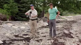
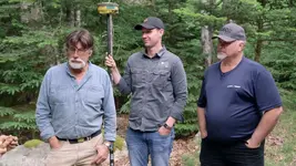
On Season 7… the Lagina’s Crew on locating a find, used their GPS (Global Positioning System) Device to secure its location... by recording and tagging it.

The Curse of Oak Island - GPS.jpegThe Curse of Oak Island - GPS.jpg

This enables them to return to its location without the need of a Paper Map.

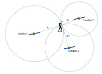
GPS works by obtaining a position from receiving a signal from at least 4 of the 24 Satellites in orbit over Earth at any given time.

Using Triangulation or Trilateration it calculates one’s exact position to one’s handset or device.

GPS Stars.png

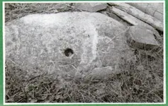
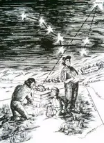
The Original Depositors used selected Stars at an exact time instead of Satellites to Tag and secure these positions with large drilled hole Marker Stones.

Oak Island - Stone 1.jpg

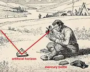
Rather than a hand held GPS Device these Depositors used what was called a Mercury Trough to find and set their Star's location on Oak Island.


Mercury Trough 3.jpgMercury Trough.jpg
 

Have you ever used a sextant? Introduced in 1731. In skilled hands they will get you to within one arc second of angle on the Earth's surface . . . a square that is 2.5 nautical miles on each side - a nautical mile being 6,000 feet. Certainly close enough to pick out landmarks and darned handy for sailors. Oak Island is 140 acres - or about 1/4 square mile. So a sextant would get you to within sight of the island but only about a 10% chance of being on it. Or, if you are standing on the island, you might be able to confirm you are on the proper island.

The artificial horizon is helpful but any elevation above sea level and just the crumminess of the apparatus produces even more error. And someone pretty sharp would have had to produce the star almanac for your target star. And if on the right day and at the right time you found the star wasn't quite where you needed it to be . . . do you then run around the whole island trying to resight with the earth rotating and the stars shifting from your vantage point. "Crap, missed it. Same time next year, guys?"

There's a reason GPS caught on and the US Government spent billions getting the satellites in place - it works WAY better than sextants and Bowditch.
 

Last edited:
If You Did Not Get It The First Time...Reread!

I have explained on previous Posts on this Thread...what I believe was the Freemason Depositor's procedure of creating their Star Map.
 

Have you ever used a sextant? Introduced in 1731. In skilled hands they will get you to within one arc second of angle on the Earth's surface . . . a square that is 2.5 nautical miles on each side - a nautical mile being 6,000 feet. Certainly close enough to pick out landmarks and darned handy for sailors. Oak Island is 140 acres - or about 1/4 square mile. So a sextant would get you to within sight of the island but only about a 10% chance of being on it. Or, if you are standing on the island, you might be able to confirm you are on the proper island.

The artificial horizon is helpful but any elevation above sea level and just the crumminess of the apparatus produces even more error. And someone pretty sharp would have had to produce the star almanac for your target star. And if on the right day and at the right time you found the star wasn't quite where you needed it to be . . . do you then run around the whole island trying to resight with the earth rotating and the stars shifting from your vantage point. "Crap, missed it. Same time next year, guys?"

There's a reason GPS caught on and the US Government spent billions getting the satellites in place - it works WAY better than sextants and Bowditch.

I have to disagree Charlie. In an experiment, I have used a framing square and a 42" level to get within 1/4 mile of Latitude using the North Star. I didn't use my sextant as I was trying to duplicate a 14th century navigation scenario. Of course this was on land and not subject to a bouncing sea. I didn't try Longitude, but believe with accurate timing at Noon could come just as close.

Cheers, Loki

You are so right. I have checked out their latitude measurements. Around 1400 A.D. they were within 6 seconds of Latitude. But in the past 600 years I have found that our latitude has moved down about 7 or 8 seconds until 2012. We are now adding latitude again. They were pretty much spot on.
 

One minute of longitude is 1 nautical mile...about 1800 meters at the equator. One second of longitude is approx. 30 meters (100 ft.) at the equator, and gets shorter as you increase in latitude. Degrees/minutes/seconds of latitude remain the same.
 

You are so right. I have checked out their latitude measurements. Around 1400 A.D. they were within 6 seconds of Latitude. But in the past 600 years I have found that our latitude has moved down about 7 or 8 seconds until 2012. We are now adding latitude again. They were pretty much spot on.

But again that is not on the deck of a ship at sea.
I consider myself qualified in the subject of navigation having been one of the first to use Loran in a small airplane until GPS made that instantly obsolete.
Loran was a treat, even going completely offline on occasion, such as when flying VFR above the clouds over Quebec, fortunately I had other options.

Cheers, Loki
 

Last edited:
One minute of longitude is 1 nautical mile...about 1800 meters at the equator. One second of longitude is approx. 30 meters (100 ft.) at the equator, and gets shorter as you increase in latitude. Degrees/minutes/seconds of latitude remain the same.

Still latitude changes with the universe cycle of 25,800 years. At the Spring equinox we start adding latitude and at the Fall equinox we again start adding latitude. That is why the Earth tilts. But anyway the latitude does not stay constant according to the Stars as the Stars move in latitude according to the cycle. The Spring and Fall Equinox are 12,900 years from one to the other.
 

Still latitude changes with the universe cycle of 25,800 years. At the Spring equinox we start adding latitude and at the Fall equinox we again start adding latitude. That is why the Earth tilts. But anyway the latitude does not stay constant according to the Stars as the Stars move in latitude according to the cycle. The Spring and Fall Equinox are 12,900 years from one to the other.


Hmm, I thought latitude was only determined by the position of the Earths Poles.

Cheers, Loki
 

Last edited:
Hmm, I thought latitude was only determined by the position of the Earths Poles.

Cheers, Loki

The Spring Equinox was in Taurus during the time of Moses. We have just entered Aquarius. When the Spinx was built we were in Leo about 12,900 years ago. The Pyramids all came later. Some just before Taurus of Moses days. At that time Orion was due West of the Spinx. Really marvelous how everything works. There is another cycle out there of 400,000 years and another of 1,100,000 years. I have not worked on those two yet.
 

I have explained on previous Posts on this Thread...what I believe was the Freemason Depositor's procedure of creating their Star Map.
Since there is no proof that the Freemasons had anything to do with your star map or Oak Island, and as a Mason myself, I can tell you that they did not, perhaps you could replace the Freemasons, with your name, calling it the Robots star map?
 

Since there is no proof that the Freemasons had anything to do with your star map or Oak Island, and as a Mason myself, I can tell you that they did not, perhaps you could replace the Freemasons, with your name, calling it the Robots star map?

I would...but I do not approve of...Plagiarism!
 

But posting false claims is OK?
you have some weird values

I do not see any false claims...only a hypothesis!

"A hypothesis is a proposed explanation for a phenomenon. For a hypothesis to be a scientific hypothesis, the scientific method requires that one can test it. Scientists generally base scientific hypotheses on previous observations that cannot satisfactorily be explained with the available scientific theories."
 

Last edited:
I do not see any false claims...only a hypothesis!

"A hypothesis is a proposed explanation for a phenomenon. For a hypothesis to be a scientific hypothesis, the scientific method requires that one can test it. Scientists generally base scientific hypotheses on previous observations that cannot satisfactorily be explained with the available scientific theories."
OK, so you are saying that the involvement of the Freemasons is only a hypothesis, then please substantiate that with some interpreted evidence.
 

Top Member Reactions

Users who are viewing this thread

Back
Top