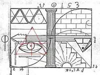
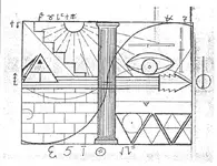
Lue Map

There are several historians and treasure hunters who have compiled information regarding the LUE which I trust. “Is the LUE map genuine or not?” I have yet to see compelling evidence either way. Spyros theory is questionable at best. My research continues and for now the final chapter has yet to be written.

Dirt

Have to say, I like your style, Dirt. :) I am a few tools out from making my first "go" at a few of the things I posted on here - hope to get at it sometime this year, if the house-general will let me, of course!
 

Has anyone come across the petroglyphs or pictographs documented in KvM's ToTVOS in their travels across Colorado or the Enchanted Land ? Anyone seen an actual photograph of them in situ ? There's scores of photography, travel blog, academic, and amateur interest websites available to us - surely there would be a photo of these unusual designs taken in the past 50 years.

ToVS LUE.webp
 

Has anyone come across the petroglyphs or pictographs documented in KvM's ToTVOS in their travels across Colorado or the Enchanted Land ? Anyone seen an actual photograph of them in situ ? There's scores of photography, travel blog, academic, and amateur interest websites available to us - surely there would be a photo of these unusual designs taken in the past 50 years.

View attachment 1677716

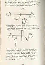
Both drawings show representations of parts of the LUE map with a conventional symbol below it - a sun in the top set and a snake in the bottom set. Miller names people who have found these alleged carvings in generalized locations, but provides no photos or other evidence. We're forced to accept that the carvings exist based on these claims alone.

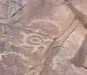
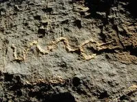
As far as the sun and snake symbols go, sure, these have been found in areas where "treasure legends" exist. Here are a couple:

sun1.JPG Snake 2.jpg
 

It didn't take very long to find. Once you locate a certain airstrip, located near an iconic natural landmark, that is relatively close to the terminus of the old Durango railroad, go 144 miles at a NNE (25°) heading - you can see that "currare" tree sitting in a big field from an altitude of 10,000 feet. Knowing that it can be seen from Google Street View (as shown from your photo\videos) helps immensely to narrow down the area.

I'm still skeptical of your theory because there's nothing out-of-the ordinary about this property that distinguishes it from any other cattle ranching land in Colorado. All properties are divided up into geometric shapes. It makes for a neat and tidy land ownership survey. It seems like you arbitrarily pulled numbers out of the LUE Map until it pointed somewhere reasonable, and constructed an "origin story" around it, which to your credit is a good one. I've done some research into the area's history and again, nothing remarkable has turned up yet. There are several large mining companies north of the area but nothing about the ranch supports a massive underground operation that could have avoided the attention of locals.

I watched the videos when he first posted them, but didn't comment on here because I didn't want to kick off another anti-KvM diatribe.

I thought some of his ideas sounded promising, but like Tom Hilton he skips over the early steps and expects everyone to accept the latter ones as fact.

The tree seemed one of the weakest points of the theory...what are the odds that the same tree has been in that spot for 80 or 90 years?
 

I'm very confused by his hostility towards people on here and his hatred of KVM and tom. Also seems like he knows a lot of the story of them for someone who stumbled upon the lue map making me wonder if he has some personal connection.

Doubt it...I think he's "filling in the blanks" a lot here. Seems to me his interest in the LUE is fairly new and the KvM / Hilton stuff was done and over by 1972.

Keep in mind Spyro also firmly believed no significant treasures could ever be found with a metal detector...Frank Fish was doing that in the 1950s.

Many of the LUE details Spyro relies on (like the amount and the depth its buried at) appear to come from thin air. I think some of his approaches to the map show promise, but otherwise he's just as broke as the rest of us who are apparently two dumb to accept his theory without question...
 

Has anyone come across the petroglyphs or pictographs documented in KvM's ToTVOS in their travels across Colorado or the Enchanted Land ? Anyone seen an actual photograph of them in situ ? There's scores of photography, travel blog, academic, and amateur interest websites available to us - surely there would be a photo of these unusual designs taken in the past 50 years.

View attachment 1677716

I've wondered the same thing, having some proof of these carvings might go a long way towards establishing the legitimacy of the LUE.

One of those was allegedly found by Larry Goddard. I know Goddard was indeed a LUE enthusiast, I have some letters and materials regarding the LUE that came by way of a man who was partnered with Goddard.
 

Hello All,

I hope spyro likes his bag of dirt. The only gold he will find is when the setting sun sets in the west and reflects its golden rays across the desert landscape.

Regards

LUE-Hawn
 

Great T Hunting tool if you can afford it?

Hello All,

Here is a great T hunting tool:

The A10 is an absolute gravimeter optimized for fast data acquisition and portability in outdoor applications. The instrument allows operation in harsh field conditions on open outdoor sites in the sun, snow, and wind.
Automated leveling
Battery operated
Temperature controlled sensor
Ideal roadside operation from a vehicle

A10 Portable Absolute Gravity Meter - Micro g LaCoste

This is what spyro needs to verify his bag of dirt.

Regards

LUE-Hawn
 

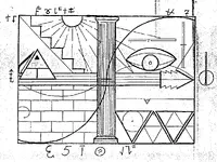
First - LUE Hawn - show me anything on the waybill which is Spanish. Right in the middle is a DORIC COLUMN - it's GREEK! Even if one wasn't aware per the Triangle Fraternity or the Scottish Rite Masons - one could deduce the pyramid is attributed to EGYPT - not Spanish in origin.

The Spanish didn't find ONE SPECK OF GOLD in the American Southwest! Read HISTORY! How many Spaniards in Coronado's party had to die to learn the truth? Tooooo MANY!

Didn't you learn anything from Tom Hilton? KvM never found ONE SPECK OF THE LUE. 'nuf said.

Ummm .. how many times do I have to 'splane that I've already spent thousands to verify the location using spectroscopic analysis?

Next, interesting snapshots White Heart - but it was immediately apparent to me - the wall shown on the waybill looked like stone or granite masonry.

Iy dum mi bes tuh hilp yooz geyz tuh quit buleevin in duh toot fary - an dat duh waybill iz spanich in orgin.

Eym gunna deeleet al mi stuf agin if yooz stil wanna beeleev the LUE is spanich. Got it?

Also - if the Treasury Department wasn't so corrupt - I'd already be working with them! Heck, I'd only take one ton and be happy.

SO - tell me what YOU'D do LUE Hawn if you "stumbled upon" 62 TONS of gold bullion, buried in a tunnel system 55 feet underground? Besides - let's see YOUR step by step analysis of the waybill - describing EVERY measurement and marking, with PRECISION. Seems like you know nothing about aviation and visual flight instruction, but I'd at least review the mechanics of a theodolite.


View attachment 1672410 View attachment 1672411 View attachment 1672413 View attachment 1672634 View attachment 1672636

spyro

I would have to put on my chest waders because of the amount of BS coming out your pie hole. I truly hope you enjoy your bag of dirt.

Regards

LUE-Hawn
 

1) Here's where it get's "interesting": a Ford Tri-Motor had the capability to carry one ton in cargo or passengers, and I didn't make the "Ford" connection to the 3rd Reich and Hitler, until the past year or so. The Ford Tri-Motor was also very efficient in needing only a short runway in high altitudes, because it had 3 motors. Hence, only 25 round trip flights would be needed.

https://en.wikipedia.org/wiki/Ford_Trimotor

Excerpt:
"One of the major uses of the Trimotor after it was superseded as a passenger aircraft by more modern aircraft like the Boeing 247 (1933) or the Douglas DC-2 (1934), then DC-3, was the carrying of heavy freight to mining operations in jungles and mountains. The Trimotor was employed for decades in this role.[16]" Click link #16 and you'll learn the Ford Tri-motor was used by Peruvian gold miners in high altitudes.

Why did Hitler award Henry Ford the Grand Cross of the German Eagle in 1938; before World War II broke out? Was it because he cached their gold in the U.S. on a remote relocation in the middle of nowhere, in high altitude, using a Ford Tri-Motor configured to carry the cache?

The closest road to the property was unpaved until 1975. It's very desolate out there.

2) I believe the pilot and "site lead" or surveyor were the only people who knew where they were. I believe they were paid to be quiet in gold. That's why I believe the pilot only provided "cryptic" information to his wife, as to the mission he executed, and the description which was passed on "2nd hand" to KvM and Hardrock Hammond, and perhaps Tom Hilton: "40 acres of gold .. a Natural Fort Knox .. two people knew where it was buried".

I believe the pilot died an untimely death, in a plane accident in 1938, and one of the valuables he left behind to his wife was the waybill. The pilot must've told her the site was a "natural Fort Knox", and perhaps she or her son wanted a "piece of the action" from KvM or Hardrock Hammond.

The surveyor could have been the land owner, a Nazi sympathizer or a highly paid lieutenant in the operation. The other crew members had NO IDEA where they were, those who excavated the site. It's very desolate out there.

As Daryl Friesen has posted on other websites, he was told that Germans or Neo-Nazi's paid a pilot after the war to search for visual "cues" around the 4 corners; searching for the site. That would indicate the crew wasn't aware where they were. In addition, one can speculate that foreign immigrants were used in the work, like the coal miners in Primero. They "pretty much" had no clue where they were, or the site location relative to the rest of the U.S.

The distances and headings are on the waybill, as I've posted.

3) The loot didn't belong to the pilot, but I believe he was trusted to keep a secret due to his military background, he was hired because he knew how to fly in high altitudes and was somewhat famous; that's how they knew he could carry out the mission. I don't believe the pilot and surveyor knew each other, for various reasons. I believe the pilot was paid well for completing the mission, in gold! His only job was to deliver cache and crew, like today's truck driver: just drop off your load and move on to the next load.

4) I believe the cache was moved for two possible reasons, as I've posted, 1) the owners feared FDR was targeting them and he'd confiscate their gold; since they knew FDR knew they'd done business with Hitler and were paid in gold; 2) the Rio Grande Southern railroad closed which would make the route to the site very difficult, if the site was used as a "secret" warehouse for refined inventory, 3) the owners of the Camp Bird mining company feared their warehoused gold would be confiscated and they moved it due to the Gold Act.

Either one, it appears it was a complex and large operation, including excavations. I do believe the story "line" that a crew went out to the site and tried to find the gold, but failed, and then decided to "leave it sit" because it was still illegal to own until 1970. I do believe those who knew about moving it eventually died between 1934 and 1970, and told few people about the "caper".

The current property owner is not wise to the whole thing; per the waybill. As I mentioned, I told the owner there might be "valuable historical artifacts" on the property. I have permission to search, but can't dig.

I hope that answers your questions.

Your best friend,
Spyro

View attachment 1637805 View attachment 1637809 View attachment 1637814 View attachment 1637824

Hello spyro,

Here is a simple request: Tell us the name of the suspected German sympathizer whose property it belonged to? You don't have to give the full name only the first letter and the last?

Perhaps then you will be believed?

Regards

LUE-Hawn
 

Regarding the theory that the sine waves are used to plot geographical coordinates: The horizontal column or "arrow of time" is OK, i guess, the "middle" line could be equator and the above & below lines are the tropics. But counting the lines in the vertical column gives an odd number, which is not useful in determining solar time or longitude (360 degrees even number etc).

Any thoughts on how our esteemed friends are convinced that the Equation of Time is indeed represented on the LUE Map ?

IMO , the only reference to Time in the LUE map , is at the beginning of the story : " Once upon a time .... "
 

Regarding the theory that the sine waves are used to plot geographical coordinates: The horizontal column or "arrow of time" is OK, i guess, the "middle" line could be equator and the above & below lines are the tropics. But counting the lines in the vertical column gives an odd number, which is not useful in determining solar time or longitude (360 degrees even number etc).

Any thoughts on how our esteemed friends are convinced that the Equation of Time is indeed represented on the LUE Map ?

Even if there was any truth to that alleged method of solution, the question of which prime meridian is used might complicate matters considerably. That's one of the pesky annoyances with longitude.
 

Reading about the fibonacci sequence reminded me of the LUE map so here I am again. As far as "time" goes... if the map is oriented north, the shadow cast from the sun on the west side of the pyramid would indicate early morning. Might also indicate "east" of something. Any conclusions or guesses I missed on what the LUE acronym might stand for? Location Underground East
 

“Lloro uracca enterrari” is what the acronym supposedly spells - though I cant recall if Von Mueller actually published that lore himself or if it was added by another.
 

“Lloro uracca enterrari” is what the acronym supposedly spells - though I cant recall if Von Mueller actually published that lore himself or if it was added by another.

I seem to remember that some unnamed person wrote “lloro uracca enterrari” on the margins of the map, which then supposedly linked the tale to Urraca Mesa. I guess it was assumed the perp was KVM, since he was regarded as "Mr. Lue". However, I don't recall that association was ever established.

Speaking of LUE Map margin notes, whaddaya make of these?

lue.jpg
 

Why is the LUE Map captioned "Redrawn exactly from the IAYAYAM Key" so casually like it goes without saying that everyone should know what it means? Why was KvM not asked to elaborate further? Why did no one seem to even care about IAYAYAM until after the death of KvM? Could "The IAYAYAM Key" simply be the name of the original map that was copied and re-named the LUE Map? Did KvM and Co. understand these acronyms or publish them in an attempt to gain information? Could it be no help in knowing?

Assuming none of the above matters:

Do we know the actual size/scale of the LUE map?
Has the "Dollar Bill Key Cipher" idea been abandoned? If not, what series bill should be used?
Does anyone still think the 4 Corners area might have anything to do with the solution?

In an attempt to simplify the starting point, I am going off the idea that there is more disinformation in the LUE map than useful information.
I have been playing with overlaying the LUE map centered on the 4 Corners area. If you mark the thick sinewave on the map and rotate the map until the thin sinewave overlaps, interesting things happen. For one, it is 33 degrees rotation to overlap the sinewaves. At the same time the shaded side of the pyramid points due north.

This is where scale might become important. If the LUE Map's original scale matches up with a dollar bill of the era, several things need to be tried. Would be interesting to scale the LUE map so that when centered with a dollar bill the pyramids align. When the pyramids align where does the key fall? On the small pyramid? Is it also 33 degrees rotation?

So now you have the dollar/key marking the spot on the LUE map and the LUE map overlayed on the 4 Corners map rotated 33 degrees and pointing due north. What scale 4 Corners map do you use? The boundary of the 4 states?

I have only just begun the overlaying and scaling but interested in thoughts on this line of direction.
 

I seem to remember that some unnamed person wrote “lloro uracca enterrari” on the margins of the map, which then supposedly linked the tale to Urraca Mesa. I guess it was assumed the perp was KVM, since he was regarded as "Mr. Lue". However, I don't recall that association was ever established.

Speaking of LUE Map margin notes, whaddaya make of these?

View attachment 1770026

Steve, IMO the markings on the side of the map is personal notes written by someone who was trying to solve the map and has used some symbols which he found in the area which he believed the LUE map fits.
The LUE map, is a modernized map, but use few Spanish tresure symbols, symbols which were the base for maps of many other groups over the world.
The Spanish used in their treasure maps to reverse the image or made a map half normal and half reversed or half up side down. One of this map which is half normal and half up side down, is the Gonzalez map which shows a gold mine in the Superstition Mt.,AZ.
The LUE map has two sides/compartiments, in which the second to the right should be turned up side down to be readable.
In the first compartiment from the left the map " tells " how the treasure site is on a mountainside facing east ( the half sun with rays ) and is on a mountain range with many peaks in line. Also the treasure site is a hill/little peak ( the triangle ) under the ridge line and has its base ( could be only the two down corners ) attached to a dam or dams ( the wall with the wave ).
In the second compartiment ( tuned up side down ) , if we draw lines from the cuts marked on the map, we will see the same triangle, but now is shown with the setting sun ( the circle without rays ) in the backround like you are looking at it from the east. There in the map is the eye which prompts you to look at the triangle that you drew, which is also the treasure site, and " tells " you where the entrance to the treasure is ( in the middle of the eye ) in comparison with the triangle shape.

lue 2.jpg

The LUE treasure is not very hard to find, enough to know where those dams are located.
 

Last edited:

Top Member Reactions

Users who are viewing this thread

Back
Top