LUE MAP THEORY, MAYBE SOME CONTEXT

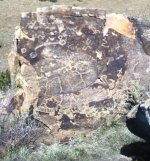
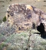
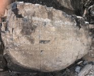
According to the research of others, Karl Von Mueller mentioned that the words LLORO URRACA ENTERRARI were found written on the LUE clue. The first letters of each word gave the LUE clue it's name. Some have speculated that it might also be a clue to solve the riddle of the LUE. The words translate to LLORO, to cry or weep, URRACA, magpie and ENTERRARI, to bury.

In northern New Mexico there is a mesa named Urraca, an interesting and mysterious place. Urraca Mesa is close to several locations where LUE caches have been found. Because of this, Urraca Mesa could be the URRACA of the LUE clue.

There is another URRACA close to the west base of Blanca Peak, the Urraca Pioneer Cemetery. This cemetery is located between Urraca Creek, to the north of the cemetery, and Pioneer Creek, to the south. I don't know if this place is the Urraca of the LUE clue, but the words LLORO, to cry or weep, and ENTERRARI, to bury, fit well with what would happen at a cemetery.

I believe this cemetery has a connection to the Kensington Runestone Map, the LUE clue and the KGC Template, as well as Treasure Mountain. I'll show you a map of the area and explain the evidence and you can decide for yourself.

urraca cemetery.jpg


You can see the location of the Urraca Pioneer Cemetery, just to the left of Blanca Peak. The cemetery is less than a mile north of the Kensington Runestone line shared by Treasure Mountain, Blanca Peak and Montvale, Virginia, further to the east.

The white line running from the cemetery to the southwest begins at a heading of 210 deg. which is a heading found on the LUE clue. This line passes just east of Pike's Stockade and over Sierro del Ojito and intersects a blue LUE clue line and a white Kensington Runestone line that comes from Treasure Mountain and is shared by Culebra Peak and Wildcat Bluff, Arkansas, to the east. One of sdcfia's friends translated Sierro del Ojito to mean, "watch out, be careful on that mountain" or "look carefully on that mountain".

The heading of the white line from Treasure Mountain begins at 103.5 deg. which is a heading found on the LUE clue and the KGC Template. The heading from Sierro del Ojito to Treasure Mountain begins at 283 deg. which is a heading found on the KGC Template.

The blue line at the intersection comes from the location that is represented by the center point of the large circle in the lower right quadrant of the LUE clue. This blue line starts at a heading of 150 deg. and extends further to the southeast to pass 4 miles east of Black Lake, New Mexico where several LUE caches were recovered.

So, this map shows the name Urraca with a connection to Treasure Mountain and Sierro del Ojito. I find Ojito, eye, especially interesting because I've found the eye associated with a clue or key.
 

lue carvings.jpg


The bottom picture shows carvings found near Conejos Peak. This is the only information that I've seen about these carvings. Does anybody have anything new about these carvings, maybe a specific location? Thank you.
 

I'd like to know if anybody knows where, from Conejos Peak, this carving was found.

lue carvings.jpg

Also, for those of you who study the LUE and Treasure Mountain legends, this section of the Conejos River looks similar to the curving line on the carving.

lue carvings conejos river.jpg
conejos river ge.jpg
 

I'd like to know if anybody knows where, from Conejos Peak, this carving was found.

View attachment 2156552
Also, for those of you who study the LUE and Treasure Mountain legends, this section of the Conejos River looks similar to the curving line on the carving.

View attachment 2156553 View attachment 2156555
I've asked the same question about the carvings and no one, that I am aware of, has ever found them in the field. So, that raises the questions of 1) Do they really exist or are they mentioned just to get you close the to area of interest and 2) If the latter, then where did KVM get the info to put in his book? Like the others before me, I seem to keep coming up with more questions than answers.
 

I've asked the same question about the carvings and no one, that I am aware of, has ever found them in the field. So, that raises the questions of 1) Do they really exist or are they mentioned just to get you close the to area of interest and 2) If the latter, then where did KVM get the info to put in his book? Like the others before me, I seem to keep coming up with more questions than answers.
When I saw the comment, about the bottom carving being found near Conejos Peak and in the vicinity of hundreds of arrows pointing to the south and east, I ran a line from the Urraca Pioneer Cemetery to Conejos Peak and found a starting heading of 248 deg, a KGC Template heading. The second line from the cemetery goes to Sierro del Ojito and starts at a heading of 210 deg which is a LUE clue heading. The white line from Treasure Mountain is a Kensington Runestone line and includes Culebra Peak and on to Wildcat Bluff in Arkansas. Notice how the two lines from Urraca Pioneer Cemetery intersect the red and blue lines, these are LUE clue lines, and the Kensington Runestone line from Treasure Mountain. Here's a map.

con pk sie ojito.jpg


The white line going east from Conejos Peak starts at a heading of 90 deg and goes over Sierro del Ojito. 4.5 miles east of Conejos Peak are the curves in the Conejos River that I think resembles the curved line on the carving. Also, notice that the curved line on the carving is just below the horizontal line. Here's the carving.

lue carvings.jpg


After pondering this drawing for several hours, I'm guessing that the triangle with the dot at the top, might indicate either Conejos Peak or the starting point. I think the horizontal line indicates to go east. The line passes just north of the curved lines on the Conejos River and continues on to the point. I wonder if the point might indicate a compass needle so that you would know that the heading is 90 deg. from the starting point. The rectangular image could represent North and South on a compass or maybe some type of terrain feature. I thought the three steps south of the vertical line might be a terrain feature but couldn't guess where it was until I read this comment from page 5 of the archeological report that I posted a couple days ago. "Within the PSSHM the topography ranges from the virtually flat floodplain of the Conejos River (where Pike’s men built their stockade) to steep slopes in excess of 30° and low cliffs around the perimeter of Sierro del Ojito. The north side of the mesa drops precipitously to the extensive wetlands along the river (Figure 5), but three distinctive ridges descend in stair step fashion from its west, southwest, and southeast sides to provide potential access routes to the summit." These three distinctive steps could be the steps shown on the carving.

Anyway, that's why I would like to find out where this carving was found. It probably doesn't make any difference, if Conejos Peak is the starting point, but it would still be nice to know.

I'm open for any other thoughts.
 

lue carvings.jpg


Something else that would be useful to know about this carving would be the measurements of all of the characters. Measurements could show distance as well as other information.

The information below the carving says there are, "Hundreds of signs and arrows in this area usually point south or east." I started a line at 180 deg. from Conejos Peak to Victorio Peak in New Mexico. Victorio Peak is the site of a big time treasure legend. The 180 deg. heading is found as a Sun ray on the LUE clue and also on the KGC Template. Two other lines intersect at Victorio Peak, A LUE clue heading of 165 deg. and a Kensington Runestone line that connects Victorio Peak, Smoke Rock Mountain, ARK. (Bob Brewer's neck of the woods) and Rocky Face Mountain, Georgia (Waterhouse Treasure). The line from Victorio Peak to Rocky Face Mountain has a heading of 78 deg. which is a KGC Template heading.

victorio peak.jpg
 

Hi LUE-Hawn,

I'm pretty confident in my theory but I'm always open for a conversation. Please explain your comment.

Thank you

Rick
Hello MD,

The LUE is in a 25 square mile envelope. Not spread out across the USA. Its confined to one state if items were found in another state it is coincidental to the main search area.

Bests In Treasure

LUE-Hawn
 

Hello MD,

The LUE is in a 25 square mile envelope. Not spread out across the USA. Its confined to one state if items were found in another state it is coincidental to the main search area.

Bests In Treasure

LUE-Hawn
Hi LUE-Hawn

Have you seen the 25 square mile envelope in any of the mapping I've posted? Is the area close to the Purgatoire Campground?

Also, are there any treasure monuments or carvings associated with the site?

Thank you.

Mdog
 

Hello All,

As I mentioned before one of my older friend’s built the road in there in the early years with his D-6 cat tractor.

I spoke with an elderly lady friend and she told me an interesting story when she was seven or eight years old (she is 94 now) her dad and uncle went treasure hunting just south of La Junta, Colorado and they were in an old riverbed and found a pair of crossed sabers in the river bottom.

This combined with another story of hidden Spanish wealth in this part of Colorado and the attached photograph from my older friend. He didn’t know how to text me the message so I took a photograph of his phone. Look at the shadow heart?

Best in Treasure

LUE-Hawn
 

Attachments

  • IMG_4404.jpeg
    IMG_4404.jpeg
    1.1 MB · Views: 24
  • IMG_4405.jpeg
    IMG_4405.jpeg
    1.7 MB · Views: 24
Hi LUE-Hawn

Have you seen the 25 square mile envelope in any of the mapping I've posted? Is the area close to the Purgatoire Campground?

Also, are there any treasure monuments or carvings associated with the site?

Thank you.

Mdog
Hello MD,

Yes and No, its close but it is not in the purg whatsoever.

Bests in Treasure

LUE-Hawn
 

To All,

What the rock tells me is there is something buried in two or three locations. You may need a ladder to get to them and the turkey track leads the way. The heart represents gold. My friend says he took the photograph over ten years ago. He wanted me to see it and gave a general location, but not exact coordinates as he could not remember (He’s 90 years old). Although he is much sharper than biden at (81 years old) during the debate last week.

Bests in Treasure

LUE-Hawn
 

Hello MD,

If you are into deciphering what inscriptions on rocks mean.a perplexing rock is the Los Lunas Decalogue Stone near Los Lunas, New Mexico. We my friend and I walked there and I viewed some interesting rock carvings on the way to the stone.

You must remember that the Early Spanish had some of the smartest people with them on their journeys and they were the Jesuit and Franciscan monks. Who at the time were the smartest and most knowledgeable people on the planet. They knew the ancient languages and knew how to inscribe them on rock, sheepskin or old paper. Thus the inscription on this rock. I studied archaic Greek and Hebrew and I made a partial decipher of the last line of the Stone “ Beware of the Serpent as it comes out of the rock” believe me if you saw the area it is probably the home to many venomous snakes. What better place to stash something than a place that has the propensity to lash out at you from some dark recess than an area that has venomous reptiles?

I’m not much at sticking my hand or arm into places that could potentially bite me bad. Please look at the attached photographs of where the Stone is located and you can understand why? At the top of the hill are rock buttresses where a person could defend it from attack by hostiles. It’s hot, rough and rugged. It wouldn’t be a nice place to die.

Bests In Treasure

LUE-Hawn
 

Attachments

  • IMG_3080.jpeg
    IMG_3080.jpeg
    1.6 MB · Views: 21
  • IMG_3075.jpeg
    IMG_3075.jpeg
    924 KB · Views: 21
  • IMG_3074.jpeg
    IMG_3074.jpeg
    1.3 MB · Views: 21
  • IMG_3073.jpeg
    IMG_3073.jpeg
    2.5 MB · Views: 23
  • IMG_3065.jpeg
    IMG_3065.jpeg
    1.7 MB · Views: 23
  • IMG_3067.jpeg
    IMG_3067.jpeg
    2.5 MB · Views: 22
  • IMG_3064.jpeg
    IMG_3064.jpeg
    1.8 MB · Views: 23
  • IMG_3053.jpeg
    IMG_3053.jpeg
    2.5 MB · Views: 23
  • IMG_3052.jpeg
    IMG_3052.jpeg
    2.9 MB · Views: 23
  • IMG_3051.jpeg
    IMG_3051.jpeg
    2.7 MB · Views: 23
  • IMG_3056.jpeg
    IMG_3056.jpeg
    1.5 MB · Views: 22
  • IMG_3048.jpeg
    IMG_3048.jpeg
    577.9 KB · Views: 23
Hello MD,

If you are into deciphering what inscriptions on rocks mean.a perplexing rock is the Los Lunas Decalogue Stone near Los Lunas, New Mexico. We my friend and I walked there and I viewed some interesting rock carvings on the way to the stone.

You must remember that the Early Spanish had some of the smartest people with them on their journeys and they were the Jesuit and Franciscan monks. Who at the time were the smartest and most knowledgeable people on the planet. They knew the ancient languages and knew how to inscribe them on rock, sheepskin or old paper. Thus the inscription on this rock. I studied archaic Greek and Hebrew and I made a partial decipher of the last line of the Stone “ Beware of the Serpent as it comes out of the rock” believe me if you saw the area it is probably the home to many venomous snakes. What better place to stash something than a place that has the propensity to lash out at you from some dark recess than an area that has venomous reptiles?

I’m not much at sticking my hand or arm into places that could potentially bite me bad. Please look at the attached photographs of where the Stone is located and you can understand why? At the top of the hill are rock buttresses where a person could defend it from attack by hostiles. It’s hot, rough and rugged. It wouldn’t be a nice place to die.

Bests In Treasure

LUE-Hawn
Typical nasty New Mexico high desert terrain.

The decalogue stone is intriguing, but the ruins on top of Mystery Mountain are the prize. Northern African style military installation with a BC star map.
Discovery of Ancient America
 

There's another Urraca Cemetery by the Great Sand Dunes. It's about 6.2 miles NNE of the Urraca Pioneer Cemetery.

Coordinates: 37 deg. 41' 22.18" N and 105 deg. 32' 32.78" W.


LUE numbers.jpg


In this picture, I measured the segments of each Sun ray in 1/16's of and inch. I believe that 1/16 of an inch is equal to 1 mile. It could be that the gaps between each segment are used to draw attention to a certain area on a map.

Here is one of Patrick D's pictures that he posted on an earlier LUE thread.

Patrick D.jpg


This is one of his Dad's pictures that shows the suspected location of a cache of gold near Rye, Colorado. I tried to figure out these locations, as best I could, and here's what I came up with.

rye,colo.jpg


The Sun ray gap on the LUE clue heading of 180 deg, is shown between the 8 and 10 mile markers. Also, if you look at the Sun rays on the LUE clue, you can see that the first segment of each ray alternates between short and long, this would keep the gaps from lining up with each other.
 

LUE starting points and lines.jpg


This map shows the LUE clue headings starting from three different points. The blue and red lines are starting from two points found on the LUE clue. As you can see, each line is hundreds of miles long and they represent the Sun rays found on the LUE clue.

This picture shows the length of the Sun rays in 1/16 of an inch, 1/16 inch equals 1 mile. These measurements could probably be used on county map or smaller areas, but it wouldn't work covering real big areas, like the United States.

LUE numbers.jpg


I believe you can find important areas, on the United States map, by using the measurements of the Sun rays between intersecting line. Here's an example.

krs 180.jpg


The red line is the 180 deg Sun ray heading from the Kensington Runestone. The length of this Sun ray, on the LUE clue, from end to end, is 20- 1/16 of an inch, or 20 miles. Following this red line south, from the Runestone, it intersects with two black lines. The black line to the north comes from Victorio Peak, NM and ends at Rocky Face Mountain, Georgia (the Waterhouse Treasure). The black line to the south comes from the Spider Rock Treasure area in Texas and ends at Montvale, Virginia (Beale Treasure). The distance between these intersecting lines is 20 miles.

Here's another example.

krs 150.jpg


This is another red line from the Kensington Runestone and has a LUE clue heading of 150 deg. The length of this Sun ray on the LUE clue is 25-1/16 of an inch which would be 25 miles. You can see that the distance between the two intersecting lines is 25 miles.

There are others.

Once you find the smaller areas, you can use the gaps on the Sun ray lines to pinpoint a specific area.
 

Here's another LUE clue segment including gaps from a LUE clue heading. Thanks to Bob Brewer for his research and search at these locations described in his book Rebel Gold.

smoke rock segment.jpg


The blue line is the 119 deg LUE clue heading from the location shown as a dot in the center of the large circle in the lower right quadrant of the LUE clue.

lue dot new 700.jpg


The length of the Sun ray that shows this heading is 26-1/16 of an inch or 26 miles. The length of the blue segment from it's intersection with the black line to it's intersection with the green line is 26 miles.

smoke rock segment.jpg


Bob described this area very well, in his book, so I knew that cache recoveries had been made by Smoke Rock Mountain and Little Missouri Falls. Bob also wrote that there were numerous treasure signs at both areas. I decided to run LUE clue Sun ray headings to see if any gaps in the rays lined up with these two places. I started with the 103.5 deg Sun ray heading. The length of the Sun ray was 38 miles with a 1 mile gap at 2 miles, a 2 mile gap at 18 miles and a 2 mile gap at 27 miles. You can see on the map how the gaps line up with Smoke Rock Mountain and Little Missouri Falls. Both places are less than a mile off the line, so if you can find the treasure symbols close to the line, you can follow them to the cache site, if you know how to follow the signs.

Thanks again Bob Brewer.
 

Hello MD,

I remember Patrick D’s photograph about the cave of gold as it relates to the cave that was found by the three prospectors that were forced into it by a pending storm and took three or four bars to Silver Cliff, Colorado at the turn of the century but were unable to find it after the snow melted? It relates to Dead Man’s Camp that was northwest of Green Horn Mountain. There is a Deadman’s Camp on the other side of the valley near the Great Sand Dunes but the one NW of Greenhorn is the one you want.

I had found it on an old map or some publication about the area and it was verified by my older friend as being near Greenhorn.

Bests In Treasure

LUE-Hawn
 

Hello MD & SDCFIA,

The KEY is the three finders could see Mt. Blanca from the mouth of the cave. You cannot see Mt. Blanca from the blue lakes area and the old Dead Man’s Camp is not far from Greenhorn Mountain.

Bests In Treasure

LUE-Hawn
 

Hello MD & SDCFIA,

The KEY is the three finders could see Mt. Blanca from the mouth of the cave. You cannot see Mt. Blanca from the blue lakes area and the old Dead Man’s Camp is not far from Greenhorn Mountain.

Bests In Treasure

LUE-Hawn

Thank you.
 

Top Member Reactions

Users who are viewing this thread

Back
Top