LDM why you cant get it !

Re: LDM why you can't get it !

JackH said:
Hello Joe,

Going thru a burial for a family member, at this time, Viet Nam Veteran. Will respond in due time, thank your for the opportunity.......Jack

i know what thats like .. my father and my brother vic ....hell of a price for a brass plack ...i still dont know if i am starting a collection of them yet ...got two more to make a set of 4 ...my own son will make 5 brass all together under a flag ...... thats just my family ...

you take care
 

Re: LDM why you can't get it !

Jack,

My condolences for your loss. For your family member, welcome home brother, and Godspeed to your new home.

Yoosn bi'ihi'daahi binaadidzool beehe'ndzili yeedaadoldi tsiyaago daadoldi' nika'zhe': With his life, his breath his power, God extends his hand and blesses you. Western Apache blessing.

Take care,

Joe
 

Re: LDM why you can't get it !

Jack, we are sorry to hear of your loss, and ditto to the words posted by Cactusjumper.
Roy
 

Re: LDM why you can't get it !

My sincere condolences.

B
 

Attachments

  • In memory.jpg
    In memory.jpg
    7.5 KB · Views: 1,180
Re: LDM why you can't get it !

Jack,

Grieve in peace, we'll pick it up when you're ready.

Ken
 

Re: LDM why you can't get it !

today i went to the grave yard and and clean off my dad's and brothers placks , and then i looked around and rememberd what jack said and i started cleaning a few other plack .. i dont know any of them.. but maybe i know them better then i think i do ... thanks jack ... :thumbsup:
 

Re: LDM why you can't get it !

Only 2 people have been willing to lay down their lives for mankind without thoughts of themselves.

Jesus - and our soldiers.

B
 

Re: LDM why you can't get it !

From Cactusjumper: Most of the people still working with the Stone Maps, I assume, have already found their hearts, in fact dozens of them have been found. For me, the question is where is the rest of the map in relation to their heart, as it is laid out on the Stone Maps.

If they are indeed maps, it should be obvious where the other markings are. Running lines from various points on the Stone Maps and seeing where they cross through other landmarks, and then doing the same thing on a topographic should prove out your theory. They either match, or they don't.

So far, the only one who has ever done that with any degree of accuracy, is me. Everyone else has to move the markings around, usually to a large extent.

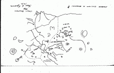
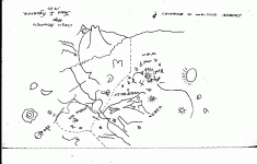
Response: Most knowledgeable interested parties on this subject 'LDM' have spent considerable hours on the 'Peralta Stone's'. I have devoted some time on them as well, but never with any solid conclusions. This (Thread) has been a Progressive learning process. My feelings, are just feelings. I did not know if the Peralta Stone's were authentic until this posting. The relationship of Map #10's info (Map #60, a given) and finally connecting (my Theory) the Dots, do I Now believe that the 'Peralta Stones' are Real, my conclusions:

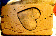
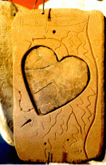
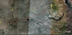
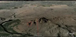
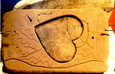
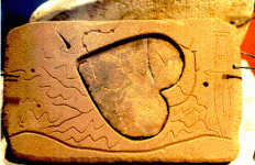
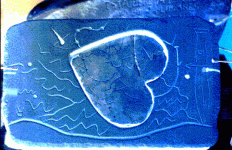
The deep line running across the bottom of the Heart Stone (mother rock) is the Salt. The Dagger (detailed, military like) is the road leading up towards the Ft Mc Dowell area. Knife part/arrow (upper guard, guardia urbano) look/start from the 4 Peaks below #1. The curved line leading from upside down (1) heads into the very center of the (Heart, symbol within symbol) below 4 Peaks, crack hiding 2nd peak, last peak extends outside heart. This is the same curved line as in Map #10 near 4 Peaks. Does the curved line mean (sound familiar) turn around 180 deg.'s 4 Peaks and look w s/w, to what the Heart Stone itself shows ? Bulls eye (small picacho, right end of trail string), "Turn around 180 deg.'s from 4 Peaks look w s/w for (small picacho, finger of God, Bulls eye, all in one, or just start here) followed by Oro symbol, 3 Red Hills (Red Mountain). The line leading away from the Bulls eye, a time table (a measurement) from 4 Peaks on horseback. Red Mountain is @ 23 miles from 4 Peaks. On horseback at @ 5 mph which I would think is a military caravan's speed, would take about 4 hours to get to other end (X), 3 Red Hills (Red Mountain). The 4 spaces between the dots on the line leading away from the Bulls eye would measure exactly that, to where the (X) is, foot of Red Mountain. As well as that line gives reference to starting well up the ridge line, below 1st of 4 Peaks.

If I placed wooden pegs into the solitary holes and attached a string connecting them, I get two out comes: 1) a dagger: connecting all pegs (reference to the Great Yavapai/Apache ?), 2) a cross: with the center of the upright from the cross, the center of the Heart Stone itself (1st. Catholic connection reason for being there, 2nd. center of all meaning, womb of Christianity).

The hole with the edge as if it was cut with a knife, pointing back to the (X) same as from the trail in center of Map #10, as coming in from the West.

With this explanation of the 'Heart Stone', two realities have surfaced: 1) Guardia Urbano, the 4 Peaks stand together, not in line behind each other. 2) Peak #1 is the closest to the Superstitions.

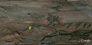
Definitively: If the curved arrow within the Heart Stone itself, is pointing at the 1st ridge below the 4 Peaks (#1, knife ref.) the angle from the ridge to Red Mountain is the same as the satellite image.

Lastly, this 'Heart' within Red Mountain is 475-500 ft high, and only under ideal conditions (shadows cast), time of day, year, can the whole Heart be seen......J
 

Attachments

  • RED MOUNTAIN LIBRARY 10.gif
    RED MOUNTAIN LIBRARY 10.gif
    11.7 KB · Views: 1,092
  • RED MOUNTAIN HEART STONE.gif
    RED MOUNTAIN HEART STONE.gif
    53.1 KB · Views: 1,106
  • RED MOUNTAIN LIBRARY 10.gif
    RED MOUNTAIN LIBRARY 10.gif
    11.7 KB · Views: 1,084
  • PERALTA STONES HEART IN 200%.GIF
    PERALTA STONES HEART IN 200%.GIF
    49.5 KB · Views: 1,028
  • RED MOUNTAIN GE HEART LINE.jpg
    RED MOUNTAIN GE HEART LINE.jpg
    271.9 KB · Views: 1,134
  • RED MOUNTAIN GE HEART HIGH.jpg
    RED MOUNTAIN GE HEART HIGH.jpg
    252.6 KB · Views: 1,112
Re: LDM why you can't get it !

Blindbowman said:
today i went to the grave yard and and clean off my dad's and brothers placks , and then i looked around and rememberd what jack said and i started cleaning a few other plack .. i dont know any of them.. but maybe i know them better then i think i do ... thanks jack ... :thumbsup:

Blindbowman:

I will take no credit for for what you have implied here. I can only see the Patriot reverence pouring out of You !

As a former Sergeant of the United States Marine Corps, I Salute your Blind Patriotic Reflection of Yourself ! Semper Fidelis, Jack
 

Re: LDM why you can't get it !

not enough hours in the day .....

i work 20-22 hours a day and i still dont finish everything on my list ...

i got over a $1200 in bike parts comeing in the mail and i will start working nights on my bike and days takeing care of my friend that had a stroke ..

yes the flag still means more then my own life to me , it flys above my fathers and brothers graves and my own soon enough ...my goverment may need help but i still beleive the people will rule again some day ...

i will fear no evil for i am American ! :coffee2:
 

Re: LDM why you can't get it !

ya they leave the other forkers behind ....lol


some bikes look better with the springers.. some just are not design for it .. like my 76 GL1000

but she didnt come with custom drilled rotors ether or cavilar pads ..

4 years and she should be done in a few weeks .. i cant wait .. but she wont see sunlight till she is 111%

jack you know why they invented the springers front end .. its to catch you when you passout ... lol :coffee2: :thumbsup:
 

Re: LDM why you can't get it !

Gentlemen, Ladies,

It has come to my attention that the Heart Stone image is too small for some to follow my Theory on the symbols there. So I am posting the image in a larger format.

Secondly, the (Heart) itself changes directions on the Heart Stone (mother rock) north (top), south (bottom), to W S/W on the Heart itself, if I haven't made that clear.


JackH said:
From Cactusjumper: Most of the people still working with the Stone Maps, I assume, have already found their hearts, in fact dozens of them have been found. For me, the question is where is the rest of the map in relation to their heart, as it is laid out on the Stone Maps.

If they are indeed maps, it should be obvious where the other markings are. Running lines from various points on the Stone Maps and seeing where they cross through other landmarks, and then doing the same thing on a topographic should prove out your theory. They either match, or they don't.

So far, the only one who has ever done that with any degree of accuracy, is me. Everyone else has to move the markings around, usually to a large extent.

Response: Most knowledgeable interested parties on this subject 'LDM' have spent considerable hours on the 'Peralta Stone's'. I have devoted some time on them as well, but never with any solid conclusions. This (Thread) has been a Progressive learning process. My feelings, are just feelings. I did not know if the Peralta Stone's were authentic until this posting. The relationship of Map #10's info (Map #60, a given) and finally connecting (my Theory) the Dots, do I Now believe that the 'Peralta Stones' are Real, my conclusions:

The deep line running across the bottom of the Heart Stone (mother rock) is the Salt. The Dagger (detailed, military like) is the road leading up towards the Ft Mc Dowell area. Knife part/arrow (upper guard, guardia urbano) look/start from the 4 Peaks below #1. The curved line leading from upside down (1) heads into the very center of the (Heart, symbol within symbol) below 4 Peaks, crack hiding 2nd peak, last peak extends outside heart. This is the same curved line as in Map #10 near 4 Peaks. Does the curved line mean (sound familiar) turn around 180 deg.'s 4 Peaks and look w s/w, to what the Heart Stone itself shows ? Bulls eye (small picacho, right end of trail string), "Turn around 180 deg.'s from 4 Peaks look w s/w for (small picacho, finger of God, Bulls eye, all in one, or just start here) followed by Oro symbol, 3 Red Hills (Red Mountain). The line leading away from the Bulls eye, a time table (a measurement) from 4 Peaks on horseback. Red Mountain is @ 23 miles from 4 Peaks. On horseback at @ 5 mph which I would think is a military caravan's speed, would take about 4 hours to get to other end (X), 3 Red Hills (Red Mountain). The 4 spaces between the dots on the line leading away from the Bulls eye would measure exactly that, to where the (X) is, foot of Red Mountain. As well as that line gives reference to starting well up the ridge line, below 1st of 4 Peaks.

If I placed wooden pegs into the solitary holes and attached a string connecting them, I get two out comes: 1) a dagger: connecting all pegs (reference to the Great Yavapai/Apache ?), 2) a cross: with the center of the upright from the cross, the center of the Heart Stone itself (1st. Catholic connection reason for being there, 2nd. center of all meaning, womb of Christianity).

The hole with the edge as if it was cut with a knife, pointing back to the (X) same as from the trail in center of Map #10, as coming in from the West.

With this explanation of the 'Heart Stone', two realities have surfaced: 1) Guardia Urbano, the 4 Peaks stand together, not in line behind each other. 2) Peak #1 is the closest to the Superstitions.

Definitively: If the curved arrow within the Heart Stone itself, is pointing at the 1st ridge below the 4 Peaks (#1, knife ref.) the angle from the ridge to Red Mountain is the same as the satellite image.

Lastly, this 'Heart' within Red Mountain is 475-500 ft high, and only under ideal conditions (shadows cast), time of day, year, can the whole Heart be seen......J
 

Attachments

  • PERALTA HEART STONE enlarged.gif
    PERALTA HEART STONE enlarged.gif
    170.3 KB · Views: 944
  • PERALTA HEART STONE enlarged.gif
    PERALTA HEART STONE enlarged.gif
    170.3 KB · Views: 934
Re: LDM why you can't get it !

JackH said:
Gentlemen, Ladies,

It has come to my attention that the Heart Stone image is too small for some to follow my Theory on the symbols there. So I am posting the image in a larger format.

Secondly, the (Heart) itself changes directions on the Heart Stone (mother rock) north (top), south (bottom), to W S/W on the Heart itself, if I haven't made that clear.


JackH said:
From Cactusjumper: Most of the people still working with the Stone Maps, I assume, have already found their hearts, in fact dozens of them have been found. For me, the question is where is the rest of the map in relation to their heart, as it is laid out on the Stone Maps.

If they are indeed maps, it should be obvious where the other markings are. Running lines from various points on the Stone Maps and seeing where they cross through other landmarks, and then doing the same thing on a topographic should prove out your theory. They either match, or they don't.

So far, the only one who has ever done that with any degree of accuracy, is me. Everyone else has to move the markings around, usually to a large extent.

Response: Most knowledgeable interested parties on this subject 'LDM' have spent considerable hours on the 'Peralta Stone's'. I have devoted some time on them as well, but never with any solid conclusions. This (Thread) has been a Progressive learning process. My feelings, are just feelings. I did not know if the Peralta Stone's were authentic until this posting. The relationship of Map #10's info (Map #60, a given) and finally connecting (my Theory) the Dots, do I Now believe that the 'Peralta Stones' are Real, my conclusions:

The deep line running across the bottom of the Heart Stone (mother rock) is the Salt. The Dagger (detailed, military like) is the road leading up towards the Ft Mc Dowell area. Knife part/arrow (upper guard, guardia urbano) look/start from the 4 Peaks below #1. The curved line leading from upside down (1) heads into the very center of the (Heart, symbol within symbol) below 4 Peaks, crack hiding 2nd peak, last peak extends outside heart. This is the same curved line as in Map #10 near 4 Peaks. Does the curved line mean (sound familiar) turn around 180 deg.'s 4 Peaks and look w s/w, to what the Heart Stone itself shows ? Bulls eye (small picacho, right end of trail string), "Turn around 180 deg.'s from 4 Peaks look w s/w for (small picacho, finger of God, Bulls eye, all in one, or just start here) followed by Oro symbol, 3 Red Hills (Red Mountain). The line leading away from the Bulls eye, a time table (a measurement) from 4 Peaks on horseback. Red Mountain is @ 23 miles from 4 Peaks. On horseback at @ 5 mph which I would think is a military caravan's speed, would take about 4 hours to get to other end (X), 3 Red Hills (Red Mountain). The 4 spaces between the dots on the line leading away from the Bulls eye would measure exactly that, to where the (X) is, foot of Red Mountain. As well as that line gives reference to starting well up the ridge line, below 1st of 4 Peaks.

If I placed wooden pegs into the solitary holes and attached a string connecting them, I get two out comes: 1) a dagger: connecting all pegs (reference to the Great Yavapai/Apache ?), 2) a cross: with the center of the upright from the cross, the center of the Heart Stone itself (1st. Catholic connection reason for being there, 2nd. center of all meaning, womb of Christianity).

The hole with the edge as if it was cut with a knife, pointing back to the (X) same as from the trail in center of Map #10, as coming in from the West.

With this explanation of the 'Heart Stone', two realities have surfaced: 1) Guardia Urbano, the 4 Peaks stand together, not in line behind each other. 2) Peak #1 is the closest to the Superstitions.

Definitively: If the curved arrow within the Heart Stone itself, is pointing at the 1st ridge below the 4 Peaks (#1, knife ref.) the angle from the ridge to Red Mountain is the same as the satellite image.

Lastly, this 'Heart' within Red Mountain is 475-500 ft high, and only under ideal conditions (shadows cast), time of day, year, can the whole Heart be seen......J
 

Attachments

  • PERALTA HEART STONE enlarged 2.gif
    PERALTA HEART STONE enlarged 2.gif
    170.3 KB · Views: 952
Re: LDM why you can't get it !

One slight descriptive change:

The Dagger most probably should be labeled "Rio Verde area, north of the Salt", as Ft Mc Dowell was not established prior the the Legendary Massacre.

In this case I would think that the Dagger/Knife would represent the Native Indians collectively living in that area, the great Pima-Maricopa. This would also give precedence to the close relationship between a working Spanish gold mining Expedition and their continued (doomed) annual invasion of the local Residents comfort zone and its hallowed ground, Red Mountain.......J
 

Attachments

  • RED MOUNTAIN Rio Verde.jpg
    RED MOUNTAIN Rio Verde.jpg
    261.4 KB · Views: 890
Re: LDM why you can't get it !

Jack,

May I ask - I've looked, but can't seem to find it, if you have posted it - when do you think the massacre occurred? If you have posted it
already, I apologize, but, cannot seem to find it.

Beth
 

Top Member Reactions

Users who are viewing this thread

Back
Top