Is the Pit Mine really the Lost Dutchman mine?

Lynda,

I believe most distances were estimates using meets and bounds for reference. I believe most folks who did a lot of traveling in the back country had a pretty good idea of how far they could walk or ride in a certain amount of time, depending on the terrain they were traveling. In this day and age, most people have lost that ability.

In that respect, I have always doubted the folks who wrote the claim document could be off by two miles or so. Others believe it's quite possible. I suppose if they could show some other examples, I might change my mind. I hold a lot of respect for Dave Leach's reading of this whole thing. He has hiked every inch of that area and looked up all of those old mines.

Just carrying the water that Dave did, would probably (shortly) give me a heart attack trying to match it on flat ground.

Take care,

Joe
 

Just a question for clarity.

Back in the day, when claim documents were filed for distance purposes did they use straight line distances or contour distances? In other words was it as the crow flies measured or up and down the ridges?

old..we can stake a claim in about 10 minutes and never leave the house (you will have to go onsite to put up the markers )...nowadays its done on a computer with a topo map program and gps.so i guess you could say these days its as the crow flies..100 yrs ago they used a compass and shoe leather..they would measure their stride..most people cover about 3 ft per step...they would use their compass and step off 1500 foot length and 600 ft width..their location monument had to be in the middle and where they found the deposit and they would orientate the claim from there depending on which way the vein was running.....it could take a day or two depending on the terrain..as far as the paperwork goes..they didn't have to be that accurate on paper..as long as they had the claim laid out on the ground correctly...nowadays you have to include a small section of a topo map in your claim papers and mark the claim out on the map...that's why it is so hard to locate an old claim out in the field from claim papers..some of the old guys put pretty accurate directions to locate their claim on paper and some didn't..it just wasn't required back then....basically they would use a known landmark (such as a benckmark or a corner where the sections meet and give a measurement from there to describe the location...hope that answers your question
 

Just a question for clarity.

Back in the day, when claim documents were filed for distance purposes did they use straight line distances or contour distances? In other words was it as the crow flies measured or up and down the ridges?

Slope distances are not used for boundary descriptions. Straight line distances are, normally a 600'x1500' rectangle or parallelogram for a lode claim. Any overlap across other claims would have to be adjudicated, often leaving odd-shaped little fractions.

By the way, I don't know what the AZ state laws are (were), but in NM the location of the physical claim corners always trumped the location description on the filing papers - as long as the discovery point fell within a quarter section of ground, that is. That means that the discovery monument could be a thousand feet away from the described location and still be valid.

Edit: double-posted pretty much the same info azdave. Speaking of landmarks, I remember reading a lot of old location papers that began at "William's barn door", or "the fork in the road", etc.
 

Last edited:
Hi sdc, in Mexico it is the horizontal distances,

Too the Cantina, if you hadn't already drank too much Tequila or Mescal! Then it would be measurements as the barf flies!

I believe the Spanish used a pole and rope for slope and horizontal distances.

But, it's beginning to look like that old pit (Hoe) was indeed the Dutchman!

We have some cooler weather coming our way, it may be time for a trip. I'll dig out that old Audit. Unless it was blasted.
But, What no one has considered is that if it was worked out by known DH men they would've certainly had to have had a Forest Service employee in with them. It's impossible to not be discovered in that area doing so much work with out the knowledge of those Green Giants!
 

Slope distances are not used for boundary descriptions. Straight line distances are, normally a 600'x1500' rectangle or parallelogram for a lode claim. Any overlap across other claims would have to be adjudicated, often leaving odd-shaped little fractions.

By the way, I don't know what the AZ state laws are (were), but in NM the location of the physical claim corners always trumped the location description on the filing papers - as long as the discovery point fell within a quarter section of ground, that is. That means that the discovery monument could be a thousand feet away from the described location and still be valid.

Edit: double-posted pretty much the same info azdave. Speaking of landmarks, I remember reading a lot of old location papers that began at "William's barn door", or "the fork in the road", etc.

lol...too bad the pit mine wasn't a couple miles north...then it would be in maricopa county...you can research maricopa county records online clear back to 1871...in pinal county they only go back 20 yrs online...older than that you have to go to pinal county building to research
 

cactusjumper,

I do not doubt anything you have said about the two men who found the "Pit Mine" in the 1997 time period or the man to who they showed the mine or that the mine was covered in 1997. All that predated any knowledge I had about the location. So I'm not in disagreement with what you are relating.
As for the Silver Chief, all I know is that Jack Carlson researched all the mining claims in that area and came up with a template of the mining claims. He laid that template of the mining claims over the topo map of the area and the claim that fell where the "Pit Mine" is located was the Silver Chief. That is Jack's plotting of the location, not mine. I don't know why he would show the location as the Silver Chief on his map and not believe it was the Silver Chief ?
At any rate as I said it is Jack's map not mine, the little I researched of the claims in the Pit Mine area led me to the same conclusion Jack came to. I have no reason for wanting it to be the Silver Chief or not. But do others have a reason to NOT want the Pit Mine to be the Silver Chief ?

One question I asked a couple of times is, if the Pit Mine location is not the Silver Chief, what claim is it ? I've not seen Jack San Felise book or the map in his book so can't make a determination but gather his map and Jack Carlson's map do not coincide. That could be causing a lot of the confusion.

I have not ruled out the possibility that the Pit Mine could be the LDM. I lean toward it isn't but some things about the mine fit the clues quite well.

Matthew

I don't have any bone to pick here, and put one statement in BOLD because I have asked this before. The problem is that there were at least 32 silver mines in the Randolph/Rogers district, that are RECORDED. How many others were simply never filed? Was the written location notice exactly correct in describing where the claims really are? I doubt that very highly as it has proven to be not the case in any other mining district that I have been to.

As to the Pit mine being the LDM, and fitting some of the clues so well, we should then look at those clues. For instance:

  • In the Ludy/Peralta story, the Ludys meet Peralta in Mexico, work for him as 'guards' and then are repaid by a gift of the mine.
  • In the Holmes/Julia versions of Waltz, it is Waltz and Weiser that also meet Peralta in Mexico, work for him as guards, and are repaid by a gift of the mine.
  • In the Ludy/Peralta story, while one of the men is away, the Indians suddenly attack the other man at the mine, he survives long enough to get out to a cabin where he tells his story but dies shortly after.
  • In the Holmes/Julia/Reiney version, while Waltz is away from the mine, the Indians suddenly attack the other man (Weiser) fatally wounding him but he survives to reach the Pima villages and is taken to Dr John Walker, tells his tale and dies shortly after.

    These are only TWO of many similar points. And worse there is yet one other version of the Lost Dutchman mine location, which has NO Peraltas, no massacre, no desperately wounded partner and almost NO clues other than a side canyon off Pinto creek, and a requirement for a portable drywasher which was used to help find the ore vein. <the Pioneer Interviews version> Obviously, something is wrong with the LDM tale, correct? All versions can not be talking of the same mine. I hold that the Peralta/Ludy story got mixed up with Waltz's story, almost at the very start of this legend. It is easy to see how too, as one of the Ludys was named JACOB, which Barry Storm got as 'Jacobs' and they were of German heritage, and Jacob Waltz was likewise of German heritage.

    Then too we have the Peralta SILVER mine story being in circulation even before Waltz died, and Bicknell following clues he obtained from Julia that led him to a stone cabin where he found clear evidence of SILVER smelting. Yet the ore found in the candlebox by Holmes, assayed at very low silver values, which would not be the case with gold ore found in a pocket in a silver mine. It should be fairly high in silver, perhaps as much as one ounce of silver for each ounce of gold. In fact Holmes assay resulted in over 5000 ounces of gold per ton, and only TWO ounces of silver. This ore did not come from any silver mine, period.

    Of course if you hold that you can not have an opinion on the likelihood of the Pit mine being the LDM without examining it in person, then you are certainly welcome to hold that view as I am not willing to hike up to look at an old played out mine that by all evidence and documentation certainly has all the hallmarks of being one of the over 30 silver mines of the Randolph/Rogers district. I am sure that the many experts that have concluded that it IS the Lost Dutchman mine, will certainly be more than enough expert opinion to convince most people you might wish to convince. I respectfully disagree.

    I would still like to see the actual production records for all of the mines in the Randolph district, if anyone has them even if only partial records. Thanks in advance;
    :coffee2: :coffee: :coffee2:

    PS to Old, and not to pick a bone with you either, but it is not a safe assumption to judge the age of timbers found in an old mine by whether they are sawn/milled or rough sections of tree. In fact I know of a couple of people that have used rough sections of log as mine timbers very recently, and conversely, sawmills were in operation in Arizona even before 1800 (water powered) so sawn lumber was available at a very early date. As a general rule, rough timbers are more likely old, but this rule is not an absolute, any more than we would be right to assume an arrastra MUST be Spanish in origins for this ancient technology was still in use in Arizona at least in the 1930s.
 

Last edited:
Welcome back, Roy.

I agree re: timber. It gets reused all the time and since Arizona is so dry, it can stay sturdy for a surprisingly long time.
 

Last edited:
Good morning Roy, Deducer and all,

What you say is absolutely possible. That's a big part of the problem with forming an opinion based solely on one or two photographs. What we see may be the whole story or it may not. That's why eye witness accounts are so critical. We have differing accounts from very credible witnesses on what was found here. Its a puzzle.

When I weigh all that I've seen in the form of the photos and all that I've heard from the eye witnesses, and the written descriptions of the location of the claims, I (me, just me) form an opinion that this is not the Silver Chief or one of its associated Silver Chief (1, 2, 4) claims. I believe the Silver Chief and associated later Silver Chiefs were further Northwest. I could be totally wrong. Wouldn't be the first time.

In written accounts of a similar location in the area they too encountered similar ancient log shoring. The first thing they did was add new bracing. Subsequent explorations also added new bracing to the original and later added bracing. I know that happened because I have the documentation in hand. That's what I'd be expecting from the turn of the century mining at this location.

What I'm working with is degrees of probability. That's not an absolute science. There is always the possibility that even the most unlikely scenario is the correct one. Its the old comparison of hearing thundering hooves and betting on whether its a horse or a unicorn. I'm betting horse, but I can't totally rule out the unicorn. Unlikely, but one in a trillion it could be.

i have a marker on my map program that puts the silver chief a little north and west of the pit mine....when i put that marker on there or why i'm not sure...i've had this map program since 2002 so its hard telling
 

Now I know this sounds a bit uncommon, or to some maybe a bit crazy, Butt, How did the Dutchman use the bathroom and what did he use for Toilet Paper?

Reason being he probably used old newspapers or magazines and buried his dirty deeds. If he buried the Poo and used paper for his wipes we have some old Dutchman / Newspaper Potty Trails that link his time frame or DNA too the Lost Dutchman Privy Pit. I know if I was about to pull out that much gold it would make me so excited I would be Pooing all over the place!

We might just get the Poo on his location that way. Might was well we've all been digging up poo on the old feller since he passed his gas at Julia's Soda Pop Shop. I'm not suggesting I'll do it. Maybe someone with experience in Privy digs using a steel rod for finding it. Not my bag of poo...

He had to hide everything for his mine to be truly hidden. I don't think he packed it out. Although he may have become a little constipated with impaction from days in the desert he surely laid a log or two near his pit. Unless he never wiped which would be kind of stinky. I suppose he could've mixed it in with the Burro's hay and had them eat it?

But how did he get rid of the Burros Manure?

He ate it!!!

How do you think the name Burro-ito came to be used?

There's more than one pit to explore here. Hopefully, this ones smaller...surely there was a privy near the site. Maybe that second room in the two room house? Must have been tough back then you take a poo and get whacked by Indians! Plus those Indians could smell human poo from a mile out. He had to bury it for secrecy.
 

Silver Chief and Pit Mine.jpg

Silver Chief Pit Mine.JPG

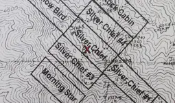
I was able to obtain a copy of Jack Carlson's map location of the Silver Chief mine with the Pit Mine (aka the Covered Mine) marked with an X. Thanks to a good friend who sent it to me and also credit goes to TE Glover.

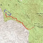
From my earlier posts you will see the topo map I posted with the route I take to get to the Pit Mine (in Red) and where I located the Silver Chief Mine (Blue rectangle).

Under my topo map is Jack Carlson's map with his location of the Silver Chief and an X that designates the Pit Mine.
You will see my map and Jack's map coincide with one another and are showing the exact same location of the Pit Mine.

This is why I believe the Pit Mine and the Silver Chief Mine are one and the same. I came by my map independently of Jack Carlson's research and had no knowledge of or input in the making of Jack's map.
I have since learned that TE Glover also wrote that Jack Carlson's map is correct, the Silver Chief and the Pit Mine share the same location.

I don't know where this leaves us in the discussion and as I stated I have no reason to want the two mines to be the same. I am just showing why, and explaining why I believe they are the same. Others may disagree and that is perfectly all right with me.

Matthew
 

Bill, you're talking s:censored:t again! But you make good sense, ...again!
The location beacon---Dutchman doody DNA!
Bill you're a genius.
 

Last edited:
Now I know this sounds a bit uncommon, or to some maybe a bit crazy, Butt, How did the Dutchman use the bathroom and what did he use for Toilet Paper?

Reason being he probably used old newspapers or magazines and buried his dirty deeds. If he buried the Poo and used paper for his wipes we have some old Dutchman / Newspaper Potty Trails that link his time frame or DNA too the Lost Dutchman Privy Pit. I know if I was about to pull out that much gold it would make me so excited I would be Pooing all over the place!

We might just get the Poo on his location that way. Might was well we've all been digging up poo on the old feller since he passed his gas at Julia's Soda Pop Shop. I'm not suggesting I'll do it. Maybe someone with experience in Privy digs using a steel rod for finding it. Not my bag of poo...

He had to hide everything for his mine to be truly hidden. I don't think he packed it out. Although he may have become a little constipated with impaction from days in the desert he surely laid a log or two near his pit. Unless he never wiped which would be kind of stinky. I suppose he could've mixed it in with the Burro's hay and had them eat it?

But how did he get rid of the Burros Manure?

He ate it!!!

How do you think the name Burro-ito came to be used?

There's more than one pit to explore here. Hopefully, this ones smaller...surely there was a privy near the site. Maybe that second room in the two room house? Must have been tough back then you take a poo and get whacked by Indians! Plus those Indians could smell human poo from a mile out. He had to bury it for secrecy.
*chuckles* I love the way your mind works!! I've been wondering about the same myself - but too 'shy' to vent it!
 

View attachment 1323238

View attachment 1323239

I was able to obtain a copy of Jack Carlson's map location of the Silver Chief mine with the Pit Mine (aka the Covered Mine) marked with an X. Thanks to a good friend who sent it to me and also credit goes to TE Glover.

From my earlier posts you will see the topo map I posted with the route I take to get to the Pit Mine (in Red) and where I located the Silver Chief Mine (Blue rectangle).

Under my topo map is Jack Carlson's map with his location of the Silver Chief and an X that designates the Pit Mine.
You will see my map and Jack's map coincide with one another and are showing the exact same location of the Pit Mine.

This is why I believe the Pit Mine and the Silver Chief Mine are one and the same. I came by my map independently of Jack Carlson's research and had no knowledge of or input in the making of Jack's map.
I have since learned that TE Glover also wrote that Jack Carlson's map is correct, the Silver Chief and the Pit Mine share the same location.

I don't know where this leaves us in the discussion and as I stated I have no reason to want the two mines to be the same. I am just showing why, and explaining why I believe they are the same. Others may disagree and that is perfectly all right with me.

Matthew

Matthew,

I'm unsure of why you are working so hard to prove a point that you are so disinterested in. The Pit Mine is a number of miles from your area of interest.

I have all of Jack and Elizabeth's books. I don't need anyone to provide me with his map, as it is published in 2010 First Edition of "Superstition Wilderness Trails East......" It looks nothing like the map you have posted. Jack has gifted me all of his books. I also have two hand sewn, leather bound editions. That 2010 edition, as far as I know, is the first time he mentions the Silver Chief Mine in any of their books.

The map can be found on page 273. You might want to find that book and compare the maps. The map he published was a photocopy of the Gustavus Cox map, drawn in 1882. It may very well be that Jack has changed his location for the Silver Chief since 2010 but his trip up to the mine was in 2008. The mine adjoining the northwest end of the Silver Chief is the Columbia. To the southeast is the "Manhatten". To the northeast are the Sky Blue and the "Three Amigos".

IMHO, The name of the mine is inconsequential. The only questions are, could this be where Jacob Waltz found his gold ore and was it a cache or an actual mine? In Jack San Felice's latest book, he devotes a number of pages to the Pit Mine. While he has pictures, he does not provide a map.

Good luck,

Joe Ribaudo
 

Last edited:
joe said,
"IMHO, The name of the mine is of inconsequential. The only questions are, could this be where Jacob Waltz found his gold ore and was it a cache or an actual mine?"

i'm with joe on that....anyway its going to be very difficult to prove if the pit was the silver chief...especially long distance... you would have to spend many days at pinal county records..and they arent very helpful..pretty much you are on your own.....if someone was onsite and spent a couple months in the area he might be able to find proof..and i use the word "might" lightly..carlson..san felise ..davis and a few other locals have all done this and they have published their finds...i dont think a person could really grasp how overgrown the area is..unless they have been there and seen it...best time to check that area out is after a forest fire....as far as the pit being the same place waltz got his goods?....i vote yes
 

Good morning Roy, Deducer and all,

What you say is absolutely possible. That's a big part of the problem with forming an opinion based solely on one or two photographs. What we see may be the whole story or it may not. That's why eye witness accounts are so critical. We have differing accounts from very credible witnesses on what was found here. Its a puzzle.

When I weigh all that I've seen in the form of the photos and all that I've heard from the eye witnesses, and the written descriptions of the location of the claims, I (me, just me) form an opinion that this is not the Silver Chief or one of its associated Silver Chief (1, 2, 4) claims. I believe the Silver Chief and associated later Silver Chiefs were further Northwest. I could be totally wrong. Wouldn't be the first time.

In written accounts of a similar location in the area they too encountered similar ancient log shoring. The first thing they did was add new bracing. Subsequent explorations also added new bracing to the original and later added bracing. I know that happened because I have the documentation in hand. That's what I'd be expecting from the turn of the century mining at this location.

What I'm working with is degrees of probability. That's not an absolute science. There is always the possibility that even the most unlikely scenario is the correct one. Its the old comparison of hearing thundering hooves and betting on whether its a horse or a unicorn. I'm betting horse, but I can't totally rule out the unicorn. Unlikely, but one in a trillion it could be.

Sound reasoning Old; however that comparison may need to be edited. Unicorns exist, and the only reason they became mythical was due to garbled communications and translations over the centuries. The original unicorns were and are, the single horned Asian rhinos. Early Greek explorers were shocked to find that unicorns indeed had cloven hooves and a single horn coming out of their head, but said they were also exceedingly ugly, covered in armored plates and would charge anyone that tried to approach them. So unicorns are not quite so unlikely after all?
RT_Asian_Rhino.jpg
<the Unicorn>

Now on the topic, and not specifically aimed at anyone in particular; if the Pit mine was the source of Waltz's gold why did Holmes assay come back with only two ounces of silver and over 5000 ounces of gold per ton? It should have been very much higher in silver, if it came from any of the mines in the Randolph district. Thanks in advance;

:coffee2: :coffee2: :coffee2:
 

Sound reasoning Old; however that comparison may need to be edited. Unicorns exist, and the only reason they became mythical was due to garbled communications and translations over the centuries. The original unicorns were and are, the single horned Asian rhinos. Early Greek explorers were shocked to find that unicorns indeed had cloven hooves and a single horn coming out of their head, but said they were also exceedingly ugly, covered in armored plates and would charge anyone that tried to approach them. So unicorns are not quite so unlikely after all?
View attachment 1323338
<the Unicorn>

Now on the topic, and not specifically aimed at anyone in particular; if the Pit mine was the source of Waltz's gold why did Holmes assay come back with only two ounces of silver and over 5000 ounces of gold per ton? It should have been very much higher in silver, if it came from any of the mines in the Randolph district. Thanks in advance;

:coffee2: :coffee2: :coffee2:

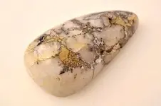
roy..when you say assay are you talking about Porterie's assay?...also here is a pic of a cab cut from ore similar to the dutchman's ..very rich in both gold and silver..it came from the santa catalina mountains near tucsongold n quartz.jpg
 

Top Member Reactions

Users who are viewing this thread

Back
Top