Is the Pit Mine really the Lost Dutchman mine?

From the discussions, it seems this particular 'Pit' mine was worked and reworked on several different occasions, so you guys could be talking about two completely different times of 'workings'.

Joe, your posted 'Location Notice' is for Silver Chief Mine No. 2 which is described as "endlines with the Silver Chief Claim".
Which of these two (or neither) is related to the 'Pit' mine we are currently discussing?

Ernie,

I did read that, but don't know if that makes the Pit Mine fall where it does. Don't believe I have the brain power to figure that out.:icon_scratch: Someone else will have to do that work.

Take care,

Joe
 

EarnieP, cactusjumper,

The original Silver Chief mine, located by J. Rogers in about 1878 is the location of the Pit mine. This original Rogers Silver Chief mining claim is a little over a mile Northwest of the Rogers Trough and Millsite. There was the original location named the Silver Chief and about three or four extentions to that claim that surrounded it, each named the Silver Chief #1, #2, #3, #4 and I don't know if there was a #5 or not. Also several other mines surrounded the Rogers Silver Chief claims.

The Silver Chief No2 claim that cactusjumper posted is an entirely different mine. It was located in 1919, 40 years after the James Rogers Silver Chief had been located and many years after Rogers Silver Chief mine had been worked out and abandoned. The Silver Chief No2 was located by a woman, Abigail Hatch. This Silver Chief No2 mine is located a little over t two miles North-Northwest of the original Rogers Silver King location.

It's confusing and to add to the confusion Abigail Hatch also located other mines adjoining her Silver Chief No2 mine that she also named the Silver Chief. Once a mine is abandoned and the claim is lost there is no rule against naming a future mine in a District the same name as a previous mine.

Another way to understand the two claim locations are different is the Rogers claim was a 1500 x 600 foot rectangle and the Abigail Hatch claim was a 1500 x 600 foot parallelogram which were laid out in different directions.

Very confusing I know.

Matthew
 

Last edited:
EarnieP, cactusjumper,

The original Silver Chief mine, located by J. Rogers in about 1878 is the location of the Pit mine. This original Rogers Silver Chief mining claim is a little over a mile Northwest of the Rogers Trough and Millsite. There was the original location named the Silver Chief and about three or four extentions to that claim that surrounded it, each named the Silver Chief #1, #2, #3, #4 and I don't know if there was a #5 or not. Also several other mines surrounded the Rogers Silver Chief claims.

The Silver Chief No2 claim that cactusjumper posted is an entirely different mine. It was located in 1919, 40 years after the James Rogers Silver Chief had been located and many years after Rogers Silver Chief mine had been worked out and abandoned. The Silver Chief No2 was located by a woman, Abigail Hatch. This Silver Chief No2 mine is located a little over t two miles North-Northwest of the original Rogers Silver King location.

It's confusing and to add to the confusion Abigail Hatch also located other mines adjoining her Silver King No2 mine that she also named the Silver King. Once a mine is abandoned and the claim is lost there is no rule against naming a future mine in a District the same name as a previous mine.

Another way to understand the two claim locations are different is the Rogers claim was a 1500 x 600 foot rectangle and the Abigail Hatch claim was a 1500 x 600 foot parallelogram which were laid out in different directions.

Very confusing I know.

Matthew

Mathew,

I believe you have explained that correctly. The claim described in the document I posted is 2 1/2 miles northwest of Rodger's Trough. As you stated, 1500 feet would be the length of the claim, along the lode. The question might be, what is the endline of the mine described? Is it the north endline or the south endline of the Silver Chief. At two and one half miles northwest of Rodger's Trough, isn't the Pit Mine way to distant to be the Silver Chief? If it's only 3000 feet from the claim in the document, how does it end up being 2 1/2 miles northwest of Rodger's Trough? Do you believe the numbers come close?


Thanks for your explanation,

Joe Ribaudo
 

Last edited:
cactusjumper,

It's confusing even if you have all the claims and maps in front of you.

First, there is no doubt about it, the Pit Mine is the same site as the original J. Rogers Silver Chief location which is one mile Northwest of the Rogers Trough and Millsite. ( I think it may be a little less than a mile but close to one mile.)

The Abigale Hatch Silver Chief No2 location is a good 3 miles Northwest of the Rogers Trough and Millsite. Clearly two separate mine locations a good 2 miles from each other. And since the maximum length of a mining claim is 1500 feet there is no way the Rogers location and the Hatch location could adjoin each other. Think of it this way, if the two locations were in a straight line from each other, there would be seven (7) mining claims in between them.

cactusjumper, you wrote: "At two and one half miles northwest of Rodger's Trough, isn't the Pit Mine way to distant to be the Silver Chief"?

Yes, at 2 1/2 miles from the Rogers Trough that would be too distant to be the Silver Chief Mine.
But, unless someone has been pulling the leg of a lot of people for a lot of years now, the Pit Mine is not 2 1/2 miles from Rogers Trough, it is no more than one (1) mile from Rogers Trough.

?

As I said, the whole matter is very confusing.

Matthew

i think another reason it is so confusing is because these claims were laid out and staked in the late 1800's..they didnt have any map programs or gps....it was all done by eyeball or just plain guesswork....the only way to find out for sure where the original claim was would be to locate the original claim markers.....and that isn't easy because some of those old claims have been reclaimed many times in 130 years and they didn't always use the same markers as the previous claimants ..you surely cant go by the claim papers because back then they didnt require you to be very accurate on paper
 

Mathew,

I believe you have explained that correctly. The claim described in the document I posted is 2 1/2 miles northwest of Rodger's Trough. As you stated, 1500 feet would be the length of the claim, along the lode. The question might be, what is the endline of the mine described? Is it the north endline or the south endline of the Silver Chief. At two and one half miles northwest of Rodger's Trough, isn't the Pit Mine way to distant to be the Silver Chief? If it's only 3000 feet from the claim in the document, how does it end up being 2 1/2 miles northwest of Rodger's Trough? Do you believe the numbers come close?


Thanks for your explanation,

Joe Ribaudo

cactusjumper,

Looking at your map, you have the Two Silver Chief mines reversed.

The old Silver Chief, the location of J. Rogers in 1878 is marked "New Silver Chief" on your map. This is also the site of the Pit Mine.

The newer site of the Abigail Hatch Silver Chief located in 1919 is marked as, Area of Silver Chief.

Someone reversed the two sites.

Matthew
 

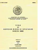
Hello Mathew, the Mexican method does not use names, as such,but by Expedent no to identify a mine. top left corner. or Title no.


.Titula.jpg
 

Last edited:
azdave35 wrote : "i think another reason it is so confusing is because these claims were laid out and staked in the late 1800's..they didnt have any map programs or gps....it was all done by eyeball or just plain guesswork....the only way to find out for sure where the original claim was would be to locate the original claim markers.....and that isn't easy because some of those old claims have been reclaimed many times in 130 years and they didn't always use the same markers as the previous claimants ..you surely cant go by the claim papers because back then they didnt require you to be very accurate on paper "

You are exactly right azdave35, in the 1880's claim papers were at eyeball technology.
But a good thing happened with J. Rogers 1878 Silver Chief mine. It became a good producer, a great producer in fact. And that caused several other mines adjoining it to be good producers also. The Morning Star, The Snap, The Chloride, The Yellow Bird, The Chloride, The World Beater and others all produced well and all adjoined the Silver Chief.

Because these mines were productive some of these claims lasted well into the 20th century and were surveyed with permanent stakes being set in the ground. Once the first claim was verified, because they all adjoined one another, it was only a matter of measurement to piece together where the other mines boundaries fell like putting a puzzle together. The final proof was the actual mine opening on each one of the claims. There are some 50 mines in the area that can be traced to their original locations because of those one or two mines that survived into the modern era and their locations were surveyed.

Jack Carlson deserves the credit for piecing together the old mining claims and putting them in their proper location on a modern day map. Greg Davis also helped to put the puzzle together. There is no doubt of where the original Silver Chief claim is today and it is the same site as the Pit mine.

Matthew

judging by the name of one of the claims the silver ore must be a chloride ore which is odd because the silver mines south of there are all sulfide ores including the silver king
 

Great info Matthew, thanks for putting it all down for us and all those future LD hunters.
 

azdave35 wrote : "judging by the name of one of the claims the silver ore must be a chloride ore which is odd because the silver mines south of there are all sulfide ores including the silver king"

That is an odd twist dave as the Silver King and Silver Queen were richer ores of native Silver while a Silver Chloride mine produces chlorargyrite or horn silver as miners call it. A poorer ore with a completely different chemical makeup although can be found in large quantity.

Matthew
 

matthew...some of the chloride ores i have worked with were very rich..they are just more difficult to extract the silver from..some chlorides can be up to 50% silver or more...unlike a silver sulfide, chloride ores aren't soluble in nitric acid but ammonia will take them into solution...i knew an old timer that found some cerargyrite nodules by mineral mountain that were 55% silver and some were as big as softballs...that would be a good find nowadays..lol
 

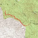
Pit Mine route.jpg

cactusjumper,

This is the route (in red) I take to the Pit Mine which is also the site of the original 1878 Silver Chief Mine.

You will see the start down in the canyon along the trail near the Rogers Trough and Millsite.
I go up onto the ridge to the west and get on top of that ridge and follow it to the northwest until I come to a saddle marked 5000 on the topo map.
From that saddle I turn east and go down through the brush to the Pit Mine.
I travel over a mile to get to the site but in a straight line it is almost exactly a mile give or take a little.
Hope this helps to understand better what I was talking about.

Matthew
 

azdave35 wrote : "i think another reason it is so confusing is because these claims were laid out and staked in the late 1800's..they didnt have any map programs or gps....it was all done by eyeball or just plain guesswork....the only way to find out for sure where the original claim was would be to locate the original claim markers.....and that isn't easy because some of those old claims have been reclaimed many times in 130 years and they didn't always use the same markers as the previous claimants ..you surely cant go by the claim papers because back then they didnt require you to be very accurate on paper "

You are exactly right azdave35, in the 1880's claim papers were at eyeball technology.
But a good thing happened with J. Rogers 1878 Silver Chief mine. It became a good producer, a great producer in fact. And that caused several other mines adjoining it to be good producers also. The Morning Star, The Snap, The Chloride, The Yellow Bird, The Chloride, The World Beater and others all produced well and all adjoined the Silver Chief.

Because these mines were productive some of these claims lasted well into the 20th century and were surveyed with permanent stakes being set in the ground. Once the first claim was verified, because they all adjoined one another, it was only a matter of measurement to piece together where the other mines boundaries fell like putting a puzzle together. The final proof was the actual mine opening on each one of the claims. There are some 50 mines in the area that can be traced to their original locations because of those one or two mines that survived into the modern era and their locations were surveyed.

Jack Carlson deserves the credit for piecing together the old mining claims and putting them in their proper location on a modern day map. Greg Davis also helped to put the puzzle together. There is no doubt of where the original Silver Chief claim is today and it is the same site as the Pit mine.

Matthew

Matthew,

That was the argument that was presented a few years ago by a very good friend of yours. It's probably correct, but does it apply only to the Silver Chief, or to all of the mines on that map? I argued that people in those days were very good at judging distance, even in mountainous terrain. They knew how long it took to go specific distances on foot, or on horseback/mule. "eyeball technology" was pretty good for pioneers.

The history you provided for the mines in the district was spot on. I am a great admirer of Jack Carlson and Elizabeth Stewart. Folks just don't get any better than those two.

I really lost interest in pinpointing the Silver Chief some time ago. What seemed more important was what was taken out of the Pit Mine in 1977,78 and 79. The other question was who put it in the mine. I think silver was around $7 an ounce back then, and you would need more than what could be produced out of that mine to make it worth the risk. As you have stated, it was worked out.

Was the Pit Mine Waltz's personal bank? I was told by the man who found it that it was covered over, much as Waltz described.

It's an interesting story in any case.

Good luck,

Joe Ribaudo
 

cactusjumper,

Looking at your map, you have the Two Silver Chief mines reversed.

The old Silver Chief, the location of J. Rogers in 1878 is marked "New Silver Chief" on your map. This is also the site of the Pit Mine.

The newer site of the Abigail Hatch Silver Chief located in 1919 is marked as, Area of Silver Chief.

Someone reversed the two sites.

Matthew

Matthew,

To be clear, I didn't believe the Pit Mine was the Silver Chief. When I stated the "New Silver Chief" I meant that someone had named it the Silver Chief.....kinda after the fact. You mentioned that someone had been pulling some legs for quite awhile. Is that a possibility? The Pit Mine was not well known, by any name, prior to it being worked and abandoned this last time. It took a very good hand to find it and show it to those folks who opened it back up. Even when Jack initially visited the mine, they called it the Generator Mine because of the generator left behind. These are just my poor memories of this whole story, so I could be remembering it all wrong.

One other question.......Jack is the best at what he does, bar none. Do you know if he ever mentions the other Silver Chief Mines in any of his books? I have them all, including two that are nicely leather bound and signed by both authors.

In any case, you are providing some excellent accepted history of the area.

Thank you for that,

Joe Ribaudo
 

Last edited:
Bill,

Good to see you are doing your homework.:dontknow: He did not find it "while it was being worked", but a number of years after it was worked. If you know anything at all about the location of the Pit Mine, you can see by the document I posted above, that it does not relate to the Silver Chief.

Of course you can post whatever you want to, even if it is shown to be completely inaccurate.


The questions remain, is the Pit Mine the Silver Chief and what mine did the Mining Company explore? No doubt that Matthew will come up with the documentation you mention.

Good luck,

Joe Ribaudo

Talk about inaccurate, this thread is about wether or not the mine is or was the Lost Dutchman which has no way of being proven one way or the other now. So being inaccurate or posting speculation is what the thread is about. I see no where it's required to be spot on historically accurate in posting here so chiding me about not doing home work is laughable. My home work consists of reading posts on here. I'm not into wasting my life away in some library or reading boring books about who's mine was where and when it was marked. Matthew has done all that work already and so have many others. You say you know who opened the mine and found the timbers that covered it right next to the Silver mine. I don't see how anyone could work a good paying silver mine right under a large gold deposit and never notice it.

It may be possible. I doubt it. If all accounts from your source are true than it may be it was the Lost Dutchman. I guess we'll never know now.
I say it may be. But I guess that would't pass the test of 100% "Accurate" information. From what Matthew has posted I would dare say none of the information about these mines is 100% accurate. But, hey, you're free to post whatever you like and Matthew will correct your inaccurate information for you.

Even though it may be a little inaccurate it still has value just as mine and your's does.


Take care,


Bill
 

Wonder where my favorite poster Hal has been lately?
Maybe he's out in the field somewhere, hope all is well.
 

Bill,

This story has been pretty well documented for some time now. Dave's role has been stated a number of times. He appears to want to stay out of it at this point, but there is plenty of fodder out there for anyone interested.

Here's some more speculation......If Waltz covered the mine over, it gives credence to them only going in for a cache, outside the mine.

In any case, it's generated some pretty intense interest.

Good luck,

Joe Ribaudo
 

Silver Chief Claim.jpg

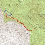
Is the Pit Mine really the Lost Dutchman Mine ?

This section of the Iron Mountain Arizona Topo Map shows the route I take (in Red) to go from the hiking trail at the Rogers Trough and Mill Site to the "Pit Mine".

The Blue rectangle is the location of the Silver Chief Mine that was located by J. Rogers in 1877-1878.

It is clear the "Pit Mine" and the Rogers "Silver Chief" mine are the same mine. This was verified and plotted from the mining records of the Randolph-Rogers mining District by Jack Carlson.

This raises the following questions:

Did Jacob Waltz take this mine from three Mexicans as the story goes and later J. Rogers found the mine and filed a claim on it ?

Did Jacob Waltz find a Mexican mine and use it to cache gold he mined from another location and later Rogers found it and claimed it ?

Was Rogers the first man to discover the ore deposit at the location and file claim on it ?

Since the Silver Chief was a Silver ore deposit, how much if any Gold was found along with the silver ?

The Lost Dutchman Mine has yet to be found and I certainly don't claim to know where it is located so to me, just about any mine could be the Lost Dutchman.
In my own opinion, having seen the Pit Mine I have to say it was a Chlorargyite Silver deposit quite rich that played out in a few years time. The Silver Chief was well known and documented in it's day. The Trough and Mill Site a mile southeast of the Silver Chief Mine was built to process the ore from this mine and a few others that adjoined it. I don't believe Gold in any appreciable quantity was ever taken from the mine.
Of course this is just my personal opinion and others may disagree.

Matthew
 

View attachment 1320732

Is the Pit Mine really the Lost Dutchman Mine ?

This section of the Iron Mountain Arizona Topo Map shows the route I take (in Red) to go from the hiking trail at the Rogers Trough and Mill Site to the "Pit Mine".

The Blue rectangle is the location of the Silver Chief Mine that was located by J. Rogers in 1877-1878.

It is clear the "Pit Mine" and the Rogers "Silver Chief" mine are the same mine. This was verified and plotted from the mining records of the Randolph-Rogers mining District by Jack Carlson.

This raises the following questions:

Did Jacob Waltz take this mine from three Mexicans as the story goes and later J. Rogers found the mine and filed a claim on it ?

Did Jacob Waltz find a Mexican mine and use it to cache gold he mined from another location and later Rogers found it and claimed it ?

Was Rogers the first man to discover the ore deposit at the location and file claim on it ?

Since the Silver Chief was a Silver ore deposit, how much if any Gold was found along with the silver ?

The Lost Dutchman Mine has yet to be found and I certainly don't claim to know where it is located so to me, just about any mine could be the Lost Dutchman.
In my own opinion, having seen the Pit Mine I have to say it was a Chlorargyite Silver deposit quite rich that played out in a few years time. The Silver Chief was well known and documented in it's day. The Trough and Mill Site a mile southeast of the Silver Chief Mine was built to process the ore from this mine and a few others that adjoined it. I don't believe Gold in any appreciable quantity was ever taken from the mine.
Of course this is just my personal opinion and others may disagree.

Matthew

nice post matthew...an old mining claim like that has probably had many owners over the years...some of the owners probably worked the mine and some didnt..anyone that owned the claim prior to WW2 more than likely worked it out of necessity to make a living..after the war the economy was much better and people didnt have to beat their brains out digging in the dirt to make a living..most people in the past 30 years that staked claims has probably not done much on that claim...most have never even been down in the shafts or tunnels (and if they did they wouldn't know what they were looking at) ...also 100 years ago most miners couldn't afford any milling equipment so they would have someone mill it for them or if it was rich enough they would bust the ore up with hammers and pick the gold out...but usually there was one guy in a district that had money (or an investor) and he would erect a mill...and he would process ore for the other miners for a percentage of the gold..as far as the pit mine being the ldm i would say it is....but hard telling for sure...the pit mine is unique because it starts out as a shaft going straight down then turns into a tunnel..which means at that level they hit a different deposit...maybe it started out as a silver chloride mine and turned into a gold mine ..hard saying for sure.....one thing i do know is nobody drills and blasts through 300 foot of hard quartz unless they are getting something pretty good
 

Top Member Reactions

Users who are viewing this thread

Back
Top