DOC NOSS-Victorio Peak OR The Caballo Mountains

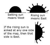
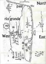
So, even though the rising sun is on the west side of the map, because the line across the sun is on the left, it indicates that the right hand side of the map is east? Just trying to understand this. I had the same impression that Don Jose had, that the rising sun symbol would be the east side of the map.....I guess if you look at with the sun sign down, with the line across the bottom, it would indicate you are looking east?

JB
 

...............also, on both of those maps, trails are shown as dotted lines or "Turkey Tracks". Even on the "Almacen Map" the solid line is labeled "Rio del Norte" and the "GILA" is a solid line as well.

Mike
 

So, even though the rising sun is on the west side of the map, because the line across the sun is on the left, it indicates that the right hand side of the map is east? Just trying to understand this. I had the same impression that Don Jose had, that the rising sun symbol would be the east side of the map.....I guess if you look at with the sun sign down, with the line across the bottom, it would indicate you are looking east?

JB

Here, I just made this for a quick reference:

View attachment 1207252 MapSun.jpg

(one of the two should show now)

Because the sun always rises in the East, ANY side of the map the rising sun is aimed at is supposed to be the East, unless there is something on the page which tells you that the map should be read in mirror image. All you do is rotate the map until your rising sun symbol is facing East (the direction of the rising sun), and your map will be properly oriented.

Mike

P.S.

The line under the half circle only signifies the horizon.
 

Last edited:
Here, I just made this for a quick reference:

View attachment 1207252

Because the sun always rises in the East, ANY side of the map the rising sun is aimed at is supposed to be the East, unless there is something on the page which tells you that the map should be read in mirror image. All you do is rotate the map until your rising sun symbol is facing East (the direction of the rising sun), and your map will be properly oriented.

Mike

P.S.

The line under the half circle only signifies the horizon.

Attachment is dead, but I see your logic, although it seems to me the rising sun is in the east and faces west.

By the way, what are these two things from that map? Volcanos?
two.jpg

Here's a couple more that look similar. Is that a dragonfly at the bottom - or a Lorrain cross?
two2.JPG
 

A DOUBLE DOG DARE!

SDCFIA,

Yes, I do interpret those as being smokers or volcanic sources of lava which formed The Malpais. They are the only things that are all black on the map, and they both have what looks like debris spewing from the tops of them. I think I remember some dragonfly petroglyphs from the Three Rivers Site that look just like that.

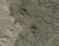
And if you aren't sure about The Malpais, then add this pic to it. Two perfectly small sized smokers/cinder cones/small volcanoes in the same area:

NMSmokers.jpg

Mike
 

Last edited:

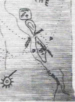
Sorry buddy. That way don't work. If you think that what I call the Rio Grande is The Jornada del Muerto, it doesn't ever take a sharp turn to the West like that. It is basically a straight line until it starts a curve to the EAST to Santa Fe. Why would a trail show an island in the middle of it? Also, another very prominent land feature on the map is "Rabbit Ears Peak" in The Organ Mountains. When the map is oriented my way, The Organs and Rabbit Ears Peak are in their correct position.

I promise you, East is the opposite of how you displayed it.

Mike
 

I believe the Willie's map is for a small region .
The mines from the west side

West side mines.jpg
 

Hello,
Although I'm not the expert on geology or passed history to the Caballo area, I do know that the Rio Grande was uncontolled by diverson dams and levees hundreds of years ago. The river meandered in the valley from about Bernallio (Albuquerque) and beyond El Paso. Places I do know that folks were able to cross the river at Rincon/Hatch/Aleman area which is relatively close to Victorio peak. Even then they had to know that the spring run-off and bad weather could hamper the crossings in those anciet times. The river never flowed in one place too long, it kept meandering east or west until modern man took control of its flow. (Elephant Butte for example). I'm not sure if the map reflects this change in seasonal flows.

Hey Riverbum,

Welcome to the discussion. I doubt the map shows anything like that. Hand drawn Travel Maps and Treasure Maps pretty much just show very prominent landmarks in an area. Treasure Maps go a bit further and show locations of things hidden. This is usually done by making up a new code or using an existing coded language. This map is very easy (the map part at least). All the landmarks are easily distinguishable, so translating map features to actual terrain features is very straightforward here. The difficulty here are all the symbols. They could basically be two things:

1. Coded symbols that have a meaning ONLY referring to map details (distance, depth, etc)

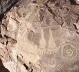
2. Symbols that are cut into rocks on site that you have to find. The easy example here are spirals. Spirals are one of the most common glyphs around the world. What do they mean here? No telling. A big issue with this possibility is that people like Doc Perrick used to go around the mountains, and any time he saw a glyph, he took a picture, then blew up the rock the glyph was on. He put the pic in his little notebook along with a description of its location. Lots of history was destroyed by that a-hole. I can't find anybody that knows anything about his little notebook either. That is likely squirreled away in some treasure hunters Hope Chest.


Mike
 

K mike, the Jornado del Muerta is way to the north for starters that takes care of one of the double dares:laughing7: :laughing7:

Soooooo, you're saying that this map only encompasses somewhere in Mexico? You know I luv ya, but you are waaaaaaaaaaaaaaaaaaaaaaaaaaaaaay off on this one. Show me what features on your version correlate to anything on a map? You say that North-South line is the Rio Grande, but NOWHERE in the ENTIRE course of that river South of Hatch, NM does it run North-South. After making the curve at Hatch, it runs basically NorthWest to SouthEast all the way to the Gulf of Mexico. The ONLY place the Rio Grande runs straight North-South is from about Hatch, NM up to where it turns slghtly East just North of Albuquerque towards Santa Fe. Sorry Pardner, that just don't work.

Mike
 

To Mike and Real, Amigo's:coffee2: Since all maps are not completely accurate ,several things to be considered on the "lil" map as far as directions are concerned is, from the south were there is a sun symbol the line does go from south to north "but"the long directional arm on the sun symbol points to the north east dotted trail,and the river,and the caballo's, the dotted trail splits before it gets to the river and rejoins again bypassing part of the river from the center of the mnts to a pass north of the mnts,goes through the caballo's
into the Joronado ,then splits,when following the dotted trail to the south it follows the same route as the river.NP:cat:
 

Yes Don Jose but the Cabllos are north of Hatch.

The Point of Rocks has always interested me but they say it was beat to death after Doc died.

NP so the trail split for different places to ford the river at certain times of the year? or did it depend on weather you wanted to go into
the Caballos, or straight to the jornado?
 

caballos seems like a logical place to trail into victorio peak. the map is incomplete, any map maker can see that, but to me it does appear to fit the caballo and regions north and south of that. also depends on the date the map was made. i love the art work of the map. i need to dig up my pictures showing why i think the map fits. i mean anyone can do a overlay on google maps. not going to be a exact fit, looks like more than one measurement of area is used to me. is the map a hoax? i dont care i enjoy what it displays what i can read of it.
 

Top Member Reactions

Users who are viewing this thread

Back
Top