DOC NOSS-Victorio Peak OR The Caballo Mountains

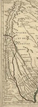
No hand drawn map will overlay onto a google maps pic perfectly. THAT is why, on hand drawn maps, you try and distinguish larger terrain features (Rio Grande, Malpais, Rabbit Ears Peak, The island in the river, the Eastward turn of the river, etc, etc, etc). Nothing more than basic terrain ID skills are needed to identify which way this map should be oriented. The symbolism and applying it to the map are a bit more problematic without a primer. Some of it can be figured out, some not so much without intimate knowledge of the individual sites.

Mike
 

ah ah not so fast Mike. On other maps there is no island, but on some it could be Victorio pk, especially on NP's lil map. I agree, that is a curious point.

Still two double dares down :laughing7::laughing7: :occasion14: tis fun Mike.

P.S. Only if the map was tranposed, would it fit
 

Last edited:
ah ah not so fast Mike. On other maps there is no island, but on some it could be Victorio pk, especially on NP's lil map. I agree, that is a curious point.

Still two double dares down :laughing7::laughing7: :occasion14: tis fun Mike.

P.S. Only if the map was tranposed, would it fit

Doesn't matter what is or is not on any other maps. This map shows a double line with a small mass in the middle. Unless it was an ancient medical record recording an arterial blockage, it is a river with an island in the middle. Your two double dares are not doing well.

Mike
 

Rio_grande_in_1718.jpg Mike show me where it crosses the Caballos, also it has your Island That is a trail that crosses the Caballos via the pass and turns south..
 

Last edited:
View attachment 1208146 Mike show me where it crosses the Caballos, also it has your Island That is a trail that crosses the Caballos via the pass and turns south..

Pardner, I think you had better take a closer look at your map there. The double line with the island is labeled "Rio Del Norte". That green line that looks like a river that branches North from the Rio Grande is the Pecos River. That smacks your theory and reinforces mine. Thanks for posting that! HAHAHA

Mike
 

Last edited:
ah ah mike mi compadre, the line coming east from above the north end of the Caballos is a trail, going through the pass at the north end of the Caballos which then turns south on the eastern side where it parallels a drainage channel on the east side of the Cabballos which drains into El Rio del Norte south of the Caballos.This is where your island possibly appears. The Pecos appears much further east.

Hey this is fun mi compadre, nothing serious. :coffee2::coffee2: The symbolic coffee will have to do until we can actually meet physically.

P.S. I have regained enough control of my left hand to type fairly well.


.
 

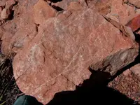
2. Symbols that are cut into rocks on site that you have to find. The easy example here are spirals. Spirals are one of the most common glyphs around the world. What do they mean here? No telling. A big issue with this possibility is that people like Doc Perrick used to go around the mountains, and any time he saw a glyph, he took a picture, then blew up the rock the glyph was on. He put the pic in his little notebook along with a description of its location. Lots of history was destroyed by that a-hole. I can't find anybody that knows anything about his little notebook either. That is likely squirreled away in some treasure hunters Hope Chest.


Gollum,

there is a rock that was found on the Caballos some time back that had a sun symbol, the number 4, RD and another symbol on it. It was posted on this site some time back called "the RD stone" just curious if you have seen it before and maybe your thoughts on what it means. I would post the picture just not sure what the rules are about posting someone else's pictures on forum. The quote above seems to fit a logical conclusion with that stone and a few others on the mountain. Either way thanks for the opinion above.

Sorry, I don't remember seeing it. I will see what I can find.

Mike
 

I'm not sure if I did this right here is the pic, someone else posted it from a separate thread awhile back.
 

Attachments

  • image.jpg
    image.jpg
    157.2 KB · Views: 172
Apologies to the original author, I figured since it was posted on this forum it may be ok.
 

mann,:coffee2:At all known or suspected area's of Treasure story's , you will find supposed treasure signs and markings,
most of these are signs put there by con men or peoples treasure hunting frustrations or failures, very few are real,NP:cat:
The key word is at KNOW places. IT is much easier at the unknown sites. Unknown, as to the people outside the loop of the original person who hid it.
 

I'm not sure if I did this right here is the pic, someone else posted it from a separate thread awhile back.

Some say otherwise, but most agree it's close to impossible to date rock carvings based on the physical evidence. To my eye, the "RD" looks modern.
 

:coffee2:Example,
Like I explained before in this thread," Doc " was a creature of habit, after locating his campsites in and around the Caballo's, there was a strange pattern forming,and more,
very close to his camps, caliche colored rocks were being found, no carved rocks, but always four caliche colored rocks in a small square pattern with one farther away from
the other three, Indicating direction of travel. after returning the next year to the same area's all the caliche colored rocks were scattered apart. and before you ask, Doc was a
creature of habit,there were certain factors about his camps.:cat:

what size are the caliche colored rocks? any specific shape to them?
do you have a guess as to whom scattered them after you found them?
wr
 

Top Member Reactions

Users who are viewing this thread

Back
Top