DOC NOSS-Victorio Peak OR The Caballo Mountains

I finally got to look at the youtube video showing the eye. Does anyone know how far they got in their research.
Also. Can somone remind me, where on the video are words bleeped. I want to see if my sister im law can make out what he said. She reads lips. Thanks.
 

I think I know where that eye monument is in the video, but if anyone knows for sure, please let me know. I want to try to find signs of that cart road they also show in the video.

The author of Lure of the Caballos places it almost directly east of the radio towers on the ridge, on the north-west side of Burbank Canyon.
 

Last edited:
Well I like the USGS, but am sure there are others as good or better. I particularly like the older images, and then get newer ones, you can see changes in the landscape.
USGS: Maps, Imagery, and Publications - Aerial Photographs and Satellite Images

I combed through the USGS long ago, and guess what I found? There are no radar, lidar, or high resolution infrared imaging of the Caballo Mountain area, The Victorio Peak area, or the Organ Mountain area.

I appreciate all the responses with suggested sources. However, this is what I keep running into. Sure, they have data sets of heavily populated areas and other areas of interest, but not of the areas we are interested in analyzing. Please take the time to delve into any sources you suggest to make sure they cover the areas in question, as they most likely do not. Of course, I look forward to being proved wrong!

Please note this applies to all the aerial and satellite multi-spectral or infrared imagery offered on the USGS website. I am not looking for regular aerial or satellite imagery in the visual part of the spectrum, as that is what we already have on Google Earth. USGS simply does not offer coverage of the interesting areas in southern NM that we want to see.
 

Last edited:
I'm working on that front! However, I doubt the US military will be granting me an aerial survey license within WSMR, or any other military installation...
 

Also, its very expensive and difficult to implement. A Samsung NX210 camera converted to a LWIR imaging chip is around $325. But then you have to acquire the lightest, most distortion free lens you can get, which will run between $700 to $1,000! Then you take your expensive camera setup and mount it in a foam UAV plane, which in and of itself has thousands of dollars in electronics hardware. Then you launch all this expensive equipment on a pre-programmed flight and hope it doesn't fly into the side of a cliff or cartwheel on landing. What fun, huh? :laughing7:
 

An adventure in itself. But then you can hire out the comb, to recuperate your expenses. Electrical powered helicopters are best. QUIET with full control and auto rotation.

You would shudder at the cost of the sat photo at Tayopa. I could retire in extreme comfort with it, but it proved invaluable in finding the key.

Why would you need such expensive camera equipment?? You can study the sex life of an ant with far less expensive equipment.
 

Last edited:
Sorry to disagree Don, but electric quadcopters only have 15 minutes of flight time with current battery capacities. So a very efficient powered flying wing is the direction I went instead, which can fly for over an hour and a half at around 40 mph, while collecting high resolution infrared images under its flight path the whole time. That translates to hundreds of images in a single flight, verses a few dozen that can be taken by a quadcopter in a single flight.

Your comment about the cost vs. the benefit of expensive aerial and/ or satellite imagery is well taken though, and I agree! That is why I have been working so hard to implement my own UAV for research, even though it takes up a lot of time and effort, and costs a lot of money. It will be worth it in the end!

However, under current FAA regulations, I would not be able to recuperate any of my costs by charging people for the imagery I produce from my UAV without a license, as that would be seen as a commercial use of a drone in the US, which is currently illegal. Other countries are passing us up while we sit and twiddle our thumbs in this area of technology.

And that camera setup is very cheap when compared to off the shelf infrared cameras that usually run anywhere from $10,000 on up to many multiples of that amount. For example, the LWIR camera I rented to take on expedition last summer had a retail price of $28,000 when it first came out!
 

Last edited:
Even with the proper gear, how are you planning to deploy the device over WSMR? We don't wish to see you being frog-hopped off to Gitmo.
 

Which is the why I was trying to find pre-existing data to analyze, since I won't be given permission to collect my own data on military installations.
 

Hi again, with those thousands of photographs how many do you need ?? One or two good ones of the area would be sufficient, they can easily be made in the electrics time, which would be more precise

As an example you could rotate the Helicopters flight path while taking the photographs and in so doing have a quasi depth .

Both fixed wing and heli each have their advantages, also the fixed wing can be equiped with a ballistic parachute, for safe recovery if hand launching in very rough terrain.
 

At this point until I can afford to buy the LWIR imagery from the vendors I located this week, I won't be able to learn anything about the area around VP. And that is assuming those vendors have such data already collected, which may not be true at all. The IR data image sets for VP may not exist for civilian use, and vendors may be prohibited from collecting such data on a military installation.

BUT the Cabbalo Mountains are not off limits, and THERE is where I will focus my search for old trails and roads to cache sites. But that too is far off, as I have to buy one piece of expensive technology at a time as finances allow.
 

I already am working with people on the OST project. I'm also planning to have both a UAV plane and a quadcopter, to cover all the bases as you suggest. And yes, a parachute recovery system would work, and they already exist for my airframe, but my autopilot lands the UAV for me hands off. I only intervene if something unusual comes up. But again, I like your thinking.

The hundreds of photos are for stitching together into one big image, and then overlaid on a topographical map, to create a 3-D map environment you can navigate through just like a Google Earth map. But you then have the ability to zoom in until you can see something the size of a dime.
 

hi matt: the aerial maps up at Tayopa definately showed the old trails. It seems that if you repeat travel over the same route you disturb the ground enough to make a recordable trail.

I have found old missions because they generally were constructed of Adobe, and when it was returned to mother Earth they were easily visible since in general they were not made of the same earth, different color and textures', but not visible on the surface.

Old bays and watercourses are easily seen.

I used them extensively, and many times they saved me constructing a parallel trail.

I have no doubt that if the ones before me had them Tayopa would have been found before me.

To fin d your goal, you use every tool available to you, even the ones considered as para normal.

Here is a graphic example of what I am saying, however, it is so large that it is easily visible.

.Main cuartel -  church at the tayopa complex..jpg
 

<cut>
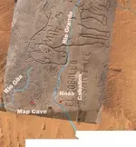
[Did anyone happen to save that post several months or a year ago that showed the horse map overlayed on a new Mexico base? I can't find it.] Anyway, I remember that with proper registration/rotation, the horse map was a very nice fit to stream flowlines (Rio Grande and Gila?), mountain locations and some other known points in New Mexico (including, I believe, the alleged "Willie's Cave" location near Granite Spring in the Caballos!). If that is true, consider this theory: Willie used the horse map to find his cave. As far as the Jesuits' involvement with the horse map is concerned, it makes more sense that the Franciscans created it, since they've been in New Mexico since Marcos de Niza in 1538 and 40, and continuously since Onate in 1598.

Finally found the overlay I was looking for - it was in a category I don't usually pay much attention to (Lost Dutchman). http://www.treasurenet.com/forums/l...omewhere-other-than-superstition-mtns-61.html Post #902.

overlay.jpg

From the poster: "Interestingly, when you register the overlay to prominent bends in the Gila River and the Rio Grande, two 'horse map' symbols plop down in intriguing locations: the 'omega' is exactly on Map Cave, a very prominent feature east of the Santa Rita mines; the cross near 'el cabollo' is at the 'Willy Daught Cave' in the Caballo Mountains, where it's speculated Doc Noss made his primary gold bullion discovery in the 1930's when he lived in Hot Springs, NM (today's Truth or Consequences)." Things certainly do seem to match up well.

Does anyone have information on "Map Cave"? I found the following cool video: [video=vimeo;28532295]http://vimeo.com/28532295[/video]

Also, these pictures, apparently from these peoples' day trip. Go to "2013", the final link in the list: Family Picture Page

Anyway, I guess I'm mess around with the overlay and see if anything else interesting comes up.
 

Top Member Reactions

Users who are viewing this thread

Back
Top