DOC NOSS-Victorio Peak OR The Caballo Mountains

Last edited:
My step-Mother was unable to get anything for me from her NASA connections. Interestingly enough, she tells me that the high resolution LWIR scans of southern NM I am after are classified, and not available to the public. Only low resolution infrared scans are made available for public viewing through USGS and other sources.
 

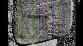
That's interesting. I also saw an overlay of that horse map directly on top of a New Mexico base which lined up real well with rivers, mountains, etc when scaled correctly. Any ideas what got "bleeped" from Schoose's commentary at about 4:50?

I thought Bob made a very good case for for this understanding of the stones, as they apply to NM. In part because of what I see in NP's map. But I don't think he would appreciate my giving my take on what he had the producer "bleep" out of the program.
 

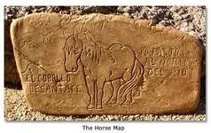
horse006.jpg So, it 'is' a Jesuit map to the deposits at Victorio Peak and Caballo mt.

Without that date, I would not consider the Map (stone), but since it was in the middle 1800's, yes, this work on the Caballo stone could be, and is acceptable. ---- it matches the other map's date by 3 years, and explains a lot.

So the Mission story does have a base. The pieces are falling in line.

the horse's tail is the trail from the rio to the eastern side of Caballo, where the treasure deposits are located, even has the same sun symbol indicating the setting sun. Notice the cross on the backside of Caballo

But where is the Pedro on the horse stone ??.

horse006.jpg horse 2.jpgNP map 2.jpg
 

Attachments

  • Victorio Peak.JPG
    Victorio Peak.JPG
    231.5 KB · Views: 199
Last edited:
<img src="http://www.treasurenet.com/forums/attachment.php?attachmentid=1090587"/> So, it 'is' a Jesuit map to the deposits at Victorio Peak and Caballo mt.

Without that date, I would not consider the Map (stone), but since it was in the middle 1800's, yes, this work on the Caballo stone could be, and is acceptable. ---- it matches the other map's date by 3 years, and explains a lot.

So the Mission story does have a base. The pieces are falling in line.

the horse's tail is the trail from the rio to the eastern side of Caballo, where the treasure deposits are located, even has the same sun symbol indicating the setting sun. Notice the cross on the backside of Caballo

But where is the Pedro on the horse stone ??.

<img src="http://www.treasurenet.com/forums/attachment.php?attachmentid=1090587"/> <img src="http://www.treasurenet.com/forums/attachmenphp?attachmentid=1090601"/><img src="http://www.treasurenet.com/forums/attachment.php?attachmentid=1090603"/>

This adds credence to my theory.
If the horse is the caballos,and I found the trail/ heart in az near superior. Then my theory that my site is connected to what you guys are working on is looking better.
The needle rock waltz talked about is on np map. If you look at the waltz map. You will see the same symbol.
So if the mining operation started at tayopa to the caballos to az. The Indian uprising we here so much about in az. Might have been larger covering more territory than we were led to believe. Such a large rebellion should have made the oral history.
So where would one look to see if there is a oral history in the tribes about it. If there is such a oral history. It might fill in some of the blanks. Didnt willie or doc claim to be part indian. Could they have learned of the caches by listing to the oral history of such a uprising.
 

My step-Mother was unable to get anything for me from her NASA connections. Interestingly enough, she tells me that the high resolution LWIR scans of southern NM I am after are classified, and not available to the public. Only low resolution infrared scans are made available for public viewing through USGS and other sources.

Are you surprised that what you want/need is classified? Funny the only things" legally "to be withheld from a foia type of thing are supposed to be stuffs that relate to oil and gas, oh well. I guess there is a test range there too and we treasure hunting types might be a threat to something, not sure what though :icon_scratch:... Lol
 

She hasn't worked for NASA since the 60's though, and she is pretty elderly now, so she may have taken a little dramatic license with what she told me.
 

Are you surprised that what you want/need is classified? Funny the only things" legally "to be withheld from a foia type of thing are supposed to be stuffs that relate to oil and gas, oh well. I guess there is a test range there too and we treasure hunting types might be a threat to something, not sure what though :icon_scratch:... Lol

The
re is a private company that provides what you are looking to get.
I dont remember their name but there was a news story about them a yea or two back. They got introuble because a ufo researcher paid them fot sat images of area 51. I hope this helps.

Their name is space imaging. They provide high resolution photos. According to a congrees meeting minutes. They provided inmages of north korea that showed ruts in the ground where trucks had driven.
They can pick up images as small as thre inches. I looked the up after posting the above statement.
 

Last edited:
View attachment 1090587 So, it 'is' a Jesuit map to the deposits at Victorio Peak and Caballo mt.

Without that date, I would not consider the Map (stone), but since it was in the middle 1800's, yes, this work on the Caballo stone could be, and is acceptable. ---- it matches the other map's date by 3 years, and explains a lot.

So the Mission story does have a base. The pieces are falling in line.

<cut>

Please explain how that stone carving could possibly be a Jesuit-made depiction of New Mexico and the Caballo Mountains. The Caballo Mountains were known as "El Perrillo Sierra" until at least 1771 - well after the Jesuits were removed from the New World. It seems Zebulon Pike is credited for naming the range the "Caballo Mountains" in 1807, forty years after the Jesuit expulsion. How do you account for this? The stone carving may refer to New Mexico, but if it does, it wasn't carved by Jesuits.

http://atlas.nmhum.org/pdfs/Urrutia1771RioAbajo.pdf
 

Last edited:
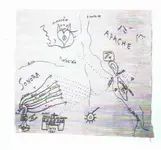
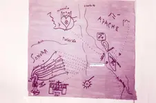
You must read my posts more carefully sdc, both were dated in the 1850's. I merely pointed out that they were they were apparantly made or modified in the middle 1800's and the NP map was correct on many previously unknown factors--including Tayopa-- whose location wasn't known until 1992. The two are tied together through common factors.Also the NP map shows it as Caballo mt.

Anyone can name it anything they want, especially a map maker who traveled the area some 40 years after the settrlements were made. They would have already been named.

I believe that was was a single mt.

So please explain to me why you have decided that this is so important, when evidence points otherwise.

First, let me get this straight. Are you saying that the "Peralta Stones" horse map is a Pimeria Alta Jesuit creation that depicts a location in New Mexico, including the "Caballo Mountains"? Yes or no?

My opinion is, if the Peralta Stone's "Caballo" does refer to New Mexico's Caballo Mountains, then:
1) The Jesuits in Pimeria Alta could not have carved it, since they were expelled from the New World in 1767, and the "Caballo Mountains" in New Mexico were called something else until at least 1771 (documented).

2) If the Jesuits carved it, it was done after 1807 (documented). From where, Europe?

3) Someone other than the Jesuits carved the stone after 1807. (My choice)

Of course, the other possibility is that the Peralta Stone's "Caballo" does not refer to the New Mexico mountains. A possibility.

[Did anyone happen to save that post several months or a year ago that showed the horse map overlayed on a new Mexico base? I can't find it.] Anyway, I remember that with proper registration/rotation, the horse map was a very nice fit to stream flowlines (Rio Grande and Gila?), mountain locations and some other known points in New Mexico (including, I believe, the alleged "Willie's Cave" location near Granite Spring in the Caballos!). If that is true, consider this theory: Willie used the horse map to find his cave. As far as the Jesuits' involvement with the horse map is concerned, it makes more sense that the Franciscans created it, since they've been in New Mexico since Marcos de Niza in 1538 and 40, and continuously since Onate in 1598.
 

Hi sdc: you posted --- First, let me get this straight. Are you saying that the "Peralta Stones" horse map is a Pimeria Alta Jesuit creation that depicts a location in New Mexico, including the "Caballo Mountains"? Yes or no?

----------
Not a simple yes or no as you well know,,so my answer at this time is (yes or no )


===========

2) If the Jesuits carved it, it was done after 1807 (documented). From where, Europe?

--------

Documented ?? Explain.

======

3) Someone other than the Jesuits carved the stone after 1807. (My choice)
-----------

Explain why it is your choice. & after 1807 ???

================


Of course, the other possibility is that the Peralta Stone's "Caballo" does not refer to the New Mexico mountains. A possibility.

------------------

of course, I agree, a possibility, so we are seeking the origin of them which so far points to someone that has the Jesuit knowledge

==============

post 1291 shows the horse map on it's side The nap that you are loking for is at - .'Diggers & Divers - P1- The secret of the Peralta Stone Maps - Treasure Hunting'

'Some hiker' posted it for me 'Yesterday', first that I had ever heard of it. It shows the stones overlay on the map.

Incidentally contrary to his remark about the salt river being in Az.,there is another to the east of Caballo mt.

And here I thought that I had a brilliant original idea sniff :icon_scratch::dontknow::censored:
 

Last edited:
Hi sdc: you posted --- First, let me get this straight. Are you saying that the "Peralta Stones" horse map is a Pimeria Alta Jesuit creation that depicts a location in New Mexico, including the "Caballo Mountains"? Yes or no?
----
Not a simple yes or no as you well know,,so my answer at this time is (yes or no )

So much for that.

2) If the Jesuits carved it, it was done after 1807 (documented). From where, Europe?
-----
Documented ?? Explain.

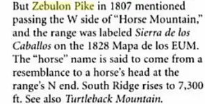
No "Caballo Mountains" prior to 1807. Zebulon Pike's journals. Quick reference is The Place Names of New Mexico, by Robert Hixson Julyan, page 54:
pike.jpg

Also, the mountains had another name before 1771.
"Nicolás Lafora was an engineer who accompanied the Marquis de Rubí on his expedition to assess securityconditions on the northern frontier. José Urrutia, a draftsman and second lieutenant, made this map, whichLafora later revised for final incusion with Rubí's report. Urrutia also drew over 20 plans of presidios (see ElPaso).

1771


Quote: (09 August 1771) On the 9th we traveled ten leagues north northwest over level ground with littleundergrowth or pasture. There are many wild palms producing very good dates different in shape and tastefrom those of Spain. After traveling four leagues, we saw, two leagues west of the road, the San Diego sierraon the river's edge. here a halt is usually made because at this point begins the Jornada del Muerto wherethere is seldom any water. Thus water is generally taken on here. After the mules have drunk, travelers setout on the road, starting in the evening to take advantage of the night's coolness. They travel two nights, oneday and part of another without stopping in order to reach Fray Cristobal. The river is encountered again afterthirty leagues. We passed San Diego on the left and set out for El Perillo. We camped on the edge of a ditchwhere there was a little rainwater. On our right and continuing north was the sierra of Los Organos. On theleft El Perillo sierra, extending in the same direction and meeting the very high and rugged El Muerto. At thefoot on the other side the river becomes very deep and narrow. Although it is possible for the animals to godown to drink, it is seldom done because of the round-about trip, the long steep descent, and the greatdanger from Apaches who always live in that vicinity and often pass by. [de Lafora, Nicolás]"
http://atlas.nmhum.org/pdfs/Urrutia1771RioAbajo.pdf

3) Someone other than the Jesuits carved the stone after 1807. (My choice)
------
Explain why it is your choice. & after 1807 ???

After 1807 - see above.

My choice because the map fits and the Jesuits couldn't have created it. Someone else must have. I don't know who.

post 1291 shows the horse map on it's side The nap that you are loking for is at - .'Diggers & Divers - P1- The secret of the Peralta Stone Maps - Treasure Hunting'

'Some hiker' posted it for me 'Yesterday', first that I had ever heard of it. It shows the stones overlay on the map.

Incidentally contrary to his remark about the salt river being in Az.,there is another to the east of Caballo mt.

And here I thought that I had a brilliant original idea sniff :icon_scratch::dontknow::censored:

No, not the overlay that Somehiker posted. There was another overlay posted on the TreasureNet forum a while back (a year or less?). I can't find the thread it was in, but it was not from a publication - it was an original post. I'll keep searching and link to it if I ever find it again.

Your theory is good, Don Jose, but I can't make the dates work with that stone map. If the horse map is anything except some sort of hoax, it sure seems to me it fits in New Mexico. And the padres would have been Franciscans. Matt was right - a lipreader might read Schoose's bleep and shed more light.
 

This adds credence to my theory.
If the horse is the caballos,and I found the trail/ heart in az near superior. Then my theory that my site is connected to what you guys are working on is looking better.
The needle rock waltz talked about is on np map. If you look at the waltz map. You will see the same symbol.
So if the mining operation started at tayopa to the caballos to az. The Indian uprising we here so much about in az. Might have been larger covering more territory than we were led to believe. Such a large rebellion should have made the oral history.
So where would one look to see if there is a oral history in the tribes about it. If there is such a oral history. It might fill in some of the blanks. Didnt willie or doc claim to be part indian. Could they have learned of the caches by listing to the oral history of such a uprising.

Howdy John,

The Indian uprising that wiped out the Peralta mining party is very well documented. Somehiker had posted a video about the U.S./Mexican war sometime back. In that video they mentioned the U.S. Army official that talked to the Apache of Arizona to make them our allies. They convinced the Apache that is they helped the soldiers fight against Mexico, they would be better off if we won the war. The Apache had been fighting the Mexicans for years, so it was not hard to convince them. I don't think the Apache took notes of all the Mexicans they killed during the war.

Homar
 

I have been educating myself on remote sensing technologies available from satellite, and it appears my step-Mother was incorrect. There are several companies that sell high resolution, multispectral satellite imaging, but it ain't cheap! I also learned that an infrared satellite image with a resolution of 30 meters can still show a roadway that was only 5 meters wide. Its going to get interesting!
 

I have been educating myself on remote sensing technologies available from satellite, and it appears my step-Mother was incorrect. There are several companies that sell high resolution, multispectral satellite imaging, but it ain't cheap! I also learned that an infrared satellite image with a resolution of 30 meters can still show a roadway that was only 5 meters wide. Its going to get interesting!

Just to point out something here - satellite photos are great, but the satellites taking the photos are actually some 20,000 miles above the Earth. Aerial photos are often shot by planes flying at 10,000 feet. <if memory serves, correction welcome but the point is the aerial photos are shot at very much lower altitude than satellite images> You get much better detail from the aerial photos than any satellite images, just from the basic distance of the respective cameras.

Please do continue,
Oroblanco

:coffee: :coffee2: :coffee2:
 

I would like to find a source for aerial images vs. satellite images as well, you don't happen to have a company in mind do you?
 

Top Member Reactions

Users who are viewing this thread

Latest Discussions

Back
Top