Charliejr Signs and Adventures.

i still think the jesuit or later kgc laid it out showing the rock pointing different dir
this rock goes 2 to 4 ton havent dug up west side to see how far it goes down
to see if it might have a pivot point

what other way to throw a person off but to have rock laying one dir and set it up
with rock actually going another dir
 

Last edited:
on trail

I agree with you and believe you @Poorfarm. These best we can do is keep hacking away at it. Throw some ideas around and see how far we can get with it.

Ok, I found the cemetery (4 way). The road goes all the way down to woods and dead ends.
 

Last edited:
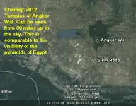
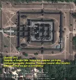
Ok, I was looking around at other ancient structures and here is one that is really spectacular.

Angkor Wat 1.png
Angkor Wat 2.png
There is supposed to be a second picture to this. All of Tnet's new gizmos are driving me crazy. (They must have kiddie programmers eager to slap every God given feature into the site.) This site has so many damn pop-ups and advertisements, I am surprised the pop-ups don't have pop-up's advertising pop-up's. (Guess they never heard of the motto: "K.I.S.S. -Keep it simple stupid.") See, the problem is, they are thinking like programmers, not users.

Ok, will get the second picture up sometime. Damn this new Tnet *GRRRR*.

Well damn, Tnet crashed my computer because the Adobe B.S. jammed up.


And keeps giving me this damn message Your submission could not be processed because a security token was missing.<br />
<br />
If this occurred unexpectedly, please <a href="sendmessage.php">inform the administrator</a> and describe the action you performed before you received this error.

Ta hell with a message, where do I insert my boot. Boy I tell ya, I could beat somebody with my walkin cane right now.
 

Last edited:
Hello folks. Tonight, I do want to say regardless of the learning curve and use here on TNET. I am glad to still be here to share what I can. I'm thinking I would like to release my entire Kmz and Kml library. I wouldn't say that it is up, but I do search and update it on a regular basis.

Let's see. If I can find out how to attach a Google Earth file, I will release as much as I can get uploaded. I do have I believe a rather large number of Desert Magazine PDF's (4.16 Gigs worth). Sadly, I do not believe my connection can handle it. But, time to get started.


Ouch. Just found out my Kmz's can't be bigger than 23, so, not going to be able to post. Ok, next step, mediafire (don't know if that will work either).
 

Last edited:
Ok folks, I got a Kenworthy pdf and a Mary Carson pdf, Yama-s-h-i-t-a pdf. Willing ta make a trade if you got something to trade.
 

In reference to the gigantic Spanish soldier head I found -if anyone who lives out west wants to find it (I mean really go to it), I will give you my directions how to get there. It is along "real Spanish trails", pre-Jesuit, not the tourist trail they call the Spanish trail. I also have found other things in this area of gigantic figures on the mountains that are no guess work as to what they are. If you are looking for a way to confirm Kenworthy or wanting to see monuments that would make Kenworthy proud, let me know.

One catch - you must give me credit, and I will put you within 50-100 miles and you must actually call(talk) to me with a pre-planned GPS I will give you when you reach the starting point. You must also take a picture (with present dated upon picture when you reach the first point of contact).

Only serious people will be considered. (And, there is a mine pay out for the person who goes there. Untouched for 500+ years.)
 

Last edited:
Old article, but speaks of the types of technologies being used to search areas.

Pictures: Massive Maya City Revealed by Lasers

Maya City in 3-D

Image courtesy University of Central Florida Caracol Archaeological Project

Airborne lasers have "stripped" away thick rain forests to reveal new images of an ancient Maya metropolis that's far bigger than anyone had thought.

An April 2009 flyover of the Maya city of Caracol used Light Detection and Ranging (LiDAR) equipment—which bounces laser beams off the ground—to help scientists construct a 3-D map of the settlement in western Belize. The survey revealed previously unknown buildings, roads, and other features in just four days, scientists announced earlier this month at the International Symposium on Archaeometry in Tampa, Florida. (Read about the rise and fall of the Maya in National Geographic magazine.)

University of Central Florida anthropologists Arlen and Diane Chase have spent decades hacking through the tangled undergrowth that has engulfed the powerful city—which thrived between A.D. 550 and 900. So far they've uncovered only a tiny fraction of the ruins.

"It's like literally removing all of the plant growth, so that we can see down below," Arlen Chase said.

The Chases direct the University of Central Florida Caracol Archaeological Project, a collaborative effort with the Belize Institute of Archaeology. NASA funded the 2009 LiDAR survey, which was carried out by the National Center for Airborne Laser Mapping.

—Brian Handwerk

Published May 20, 2010
 

New "Sunquake" Trigger Found: Huge Solar Belches

I have been following this for a while. It talks about a 11 year period coming to it's zenith sometime between 2012 & 2013. This means that it is more than possible the sun will *belch* forth huge solar flares and radiation. Earlier this year, certain parts of the Earth were hit with some of the earlier flares coming from the sun, although little damage was *reported*. Increases in radiation hitting the Earth will be seen more from various times with higher than average light index readings.

In no way am I telling anyone to freak out, just, apply lots of sun-screen, stay out of the sun, and, well....

*poof*
 

Albert Pike --- I have been reading his works on and off for some time. As of recent, I made a map based off of someone's information concerning the area of the Permian Basin. In some of Pike's exploration, he did go into the Permian Basin and the LLano Estacado. And, some time back, I made a map of all the KGC temples in Texas -during which time, I had read that during the later years of his life, he was going around the country doing certain things. I guess I am still of the theory that I think this man actually hid things (whether caches's or not) around the country. Mr. Pike was very wise indeed. So, if the Native Ameridians, the Spanish, and the Jesuits were smart enough to hide things in those places of others before them, by what chance do you think Mr. Pike had done the same.

I think he did. I actually think he has hidden things, not just one place, but many places. And, I do not think all of it has to do with the KGC persay, as I believe it falls more on the Masonic side of things.

Odd as it is to have a realization like this, but, the information just fell into place. How ironic. Oh, and the map I made ---yes, something is there, and even pictures -the right ones- *show glints of yellow reflection*. I'll be dog. Who'da known you could find something without even realizing you are looking at it.
 

Last edited:
Hi Charlie,

Have you ever made a map of Pike's travels after the Civil War?

I'm really enjoying the information that you have been posting.

Rick
 

@mdog, I have not, but that is one jim-dandy fine idea. I've been reading on him, and *slaps forehead* I don't know why I didn't think of that.

You Sir, are a genius. The only map I made was thinking that his Grand Design (which he alluded to) was that of extending all the rays from Washington D.C.. Now, my understanding is that he picked specific streets and places in D.C. (What for, I have no idea.) But, when I did extend the lines from D.C. across the country, in a few noted KGC places, they did fall within proximity of their locations.

@mdog, I think that right there is an important project worth taken up.

If anyone wants to help out, it would be greatly appreciated. That way, when it's put together, it can be released for all to take a gander at.

Include dates and places, and we'll map it out. (I'm excited!)
 

Last edited:
Your idea about the Masonic connection makes more sense to me than KGC. If only for the idea that there were probably a lot more Masons around the country than KGC. It would also be interesting to know what families he associated or stayed with as he travelled.

I'll try to help out on this. I read an old book from the 1920's about John Wilkes Booth and one of the chapters mentioned Pike and his encounter with a man who looked almost identical to Booth. This was in Fort Worth, Texas according to the book and I can't remember the date, but it was well after the Civil War. I'll see if the book is still at the library Monday and let you know. According to the book when Pike saw this individual, he turned pale and said something like "Oh my ... it's Booth!" He was so shaken he had to be taken to his room.

Rick
 

Ok, brief update. I believe I got mediafire working. On the new Pike map, I have created a folder. In this folder, I marked as many locations that history has shown where he was. In this file, I also placed all the Texas KGC temples, including my first template for Albert Pikes Grand Design. I don't know what the file size is yet. I do not expect this to be "all inclusive". But what I will do is make an early release, then update it as I roll along (each release should have a date of release on it.) The file will be a Kmz file that you import into Google Earth. At lastest I will release this tomorrow, or April, Sun, 8, 2012. I will upload it to media fire, copy the link, then place it here. See ya soon.

http://www.mediafire.com/?3vmy1yytuv3o1iq

^^^Ok, so maybe a little sooner. Someone please test this and let me know if it works.

(Beta Release 1)
 

Last edited:
There is a Pike County in southern Mississippi. It is east of Wilkerson County and Adams County. Now, Natchez is the oldest, continuously settled town on the Mississippi River system. It goes waaaaay back into the New Spain era and was in fact the site of a Spanish Governor's home back then. Up to and partly through the Civil War, Natchez was said to have more millionaires per capita, than anywhere else in the country. Jean Lafiette's brother had a lucritive slave smuggling operation out of the Louisiana settlement across the river from Natchez.

Now, what does all of this have to do with Albert Pike.........? He lived for a while in the Natchez area where aaalllllllll that money and power was located. Natchez was the "gateway" to new Spain, even AFTER the U.S. bought the Mississippi Territory from Spain and was the seat of POWER for many decades of Pike's life.

As an interesting tidbit of info...........there is a large contengient of the "James" family in the southwest quadrant of the state of Mississippi, too, that go back to before Mississippi became a state.
 

Hey SS, if you an expand on the map, by all means do so, and tag it at the end. This way we keep re-releasing a file. Sort of like an "open-source" mapping team. Whatever work you do, tag it and the names on the file tag become the team creators.

Who knows. If enough people with great ideas work on, think of what we could discover!
 

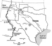
Franciscan Missionaries in Texas before 1690 | Texas Almanac

On a further note relating to Albert Pike, I was just looking at a map on this site. What I indirectly noted was that a couple of the places on the maps were also places Pike was at. Maybe this provides a "quasi-link" between KGC and Spanish/Franciscan oriented things (i.e. use of various locations and symbols of a prior group by a future group.) Considering he was a highly intellectual Mason, if he were in these areas, I have no doubts that he would be aware of certain symbols, rocks, etc. I believe this map gives validity to travel paths since old paths usually become main travel ways.
rodriguez_lopez-map.jpg
 

Last edited:
Treasure Numbers in Spanish Symbols Forum

On this site, the member "goldiver" word for word reminds me of "Rangler". Note the way he signs his post. (Dead give away.) And, as extremely long winded to -ha, leaps and yards beyond me lol. Oh, and he doesn't show any pictures on that site either. Yep, it's him, no question about it.

Looks like he has been busy with his code book on the other forum -that and a Mexican forum(?). *whew* that boy gets around.

But, this link has some good info on it.
 

Last edited:

Top Member Reactions

Users who are viewing this thread

Back
Top