Basic signs and symbols you have found

Attachments

  • 052 - Copy.JPG
    052 - Copy.JPG
    266.6 KB · Views: 624
Welcome to the forum, Ground0. I reduced the photo and turned it into a b & w to look for subtle stuff and I'm too lazy to use the sliders to look at LARGE pics. LOL


052 - Copy.JPG
 

Ground0 said:
So this would indicate ESE...and then a measure of distance? Thanx, I'm glad this topic came up and it's a GREAT thread!!!
You might try 300 varas or three leagues, depending upon the terrain.
 

I see three marks and one triangle.
A triangle triples the number close to it.

3X3=9

That is all I see here.
No angle indicators close.
am interested in where the ESE comes from.

The triangle may indicate 120 degrees which is a shade off of SE to the east But still SE.
A digital compass won't change to ESE until 115 degrees is reached so I am probably wrong.
 

Is that a crescent just on the left side of the first mark? There seems to be a darkened arrowhead on top of it pointing upward. Maybe a direction indicator??
 

Sorry about the size of the pic, and thanx for your input. That picture is that of one of three stones that are in the foundation of a bridge. Another stone is the same with an upside down triangle with three hash marks. The ESE was in reference to the "KGC SIGNS" mentioned above....an upright triangle =120 degrees. ? .
 

If it turns out to be a crescent, the distance will be in hundreds.

a C is the roman numeral for 100

900 yards would be an indicator that it could be something other than Spanish.
The KGC did use rather long measures when distancing.
 

Ground0"
I've read that the KGC would mark things they thought would be around for a very long time. Examples were railroad bridges on main lines and road bridges for major routes. Your bridge stones would fit that idea. Not saying that is what is going on, just offering this info for your consideration. The KGC is known to have left symbols and markers on county courthouses, too. If you find more things to make you think that they left these trail markers, perhaps you should read Brewer's book, Rebel Gold.
 

Here is #3 of the three stones (from right to left) I notice that the hash marks "step down"...or up depending. The hash marks on stone #1 don't "step" but are not as symmetrically spaced. I believe that the hash marks themselves indicate a distance greater that one vera each, based on the fact that this bridge was in the middle of town in its day. Further, these signs would have been underwater at that time due to the dam for the Mill just downstream...so would anything else three veras away from the signs. Of course its conceivable that this was by design, but I consider it to be improbable. Why would you put something down that would be so difficult to bring up right next to a busy bridge in a bustling little town?
 

Attachments

  • 053.JPG
    053.JPG
    338.1 KB · Views: 503
Ground0:
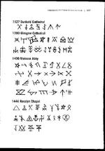
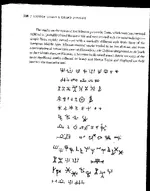
You say this bridge was in the middle of town and the marked stones were underwater. Hmmmmm. Let me throw one more curve ball. Those marks MIGHT be nothing more than mason's marks used to identify the mason or masons' group that were building the stone base of this bridge. I looked up some mason's marks in a book titled, Hidden Codes & Grand Designs, by Pierre Berloquin and found one of the marks used on the 1446 Rosslyn Chapel in Scotland was a simple equilateral triangle. Does this mean that these marks you've found ARE only mason marks for workers pay verification?? No, not necessarily. This is just one more thing to take into consideration; one more thing to prove or disprove in your search. When was that mill dam built in relationship to the construction year of the bridge?
The number of different groups who hid things around the country and their particular designs for code markers is daunting, so the need to weed out those who were not involved with a particular trail is just as important as figuring out who WAS. Log in these bridge marks and expand your search out from here; looking for other marks and symbols that might tie in with these. Are there any marks in the stones of the mill dam?
 

Shortstack said:
Ground0:
You say this bridge was in the middle of town and the marked stones were underwater. Hmmmmm. Let me throw one more curve ball. Those marks MIGHT be nothing more than mason's marks used to identify the mason or masons' group that were building the stone base of this bridge. I looked up some mason's marks in a book titled, Hidden Codes & Grand Designs, by Pierre Berloquin and found one of the marks used on the 1446 Rosslyn Chapel in Scotland was a simple equilateral triangle. Does this mean that these marks you've found ARE only mason marks for workers pay verification?? No, not necessarily. This is just one more thing to take into consideration; one more thing to prove or disprove in your search. When was that mill dam built in relationship to the construction year of the bridge?
The number of different groups who hid things around the country and their particular designs for code markers is daunting, so the need to weed out those who were not involved with a particular trail is just as important as figuring out who WAS. Log in these bridge marks and expand your search out from here; looking for other marks and symbols that might tie in with these. Are there any marks in the stones of the mill dam?

I would agree with Shortstack's line of thinking on this. The Mason's from waaayy back had their marks they would chisel on a corner of a building/monument/bridge...maybe etc. The marks were passed from Father to Son...with the Son's mark a slight variation...(just my personal thought and I do not have time to look up my sources...sorry)

Oddrock
 

Would you all consider this a mason's mark? Sadly this rock has likely been moved...not sure but i think so.
 

Attachments

  • IMG_6907640.jpg
    IMG_6907640.jpg
    70.5 KB · Views: 547
Moons:
I wouldn't want to say definitely, one way or the other. Are there other marks of this type in the area?
Here are 2 scans I took of example mason marks from the book, Hidden Codes & Grand Designs, by Pierre Berloquin. These are not the ONLY marks ever used; just some that represent the topic. The second photo is of some Minoan mason's marks.


Mason\'s marks 1.jpg

Mason\'s marks 2.jpg
 

Kim,
This isn't a mason's mark.
What direction is the arrow pointing?
Take into consideration that the marks on the lower end connect or pass through the lower branch of the arrow.

Not that direction is very important here.
 

Attachments

  • IMG_6907640.jpg
    IMG_6907640.jpg
    62.2 KB · Views: 532
Gentlemen,
Thank you all for your informative input. Masons marks normally appear on the cornerstone of a structure, that would typically be the North East corner I think. (??) These marks are on the Southwest corner of the bridge that is (get this) 33 degrees NW off of magnetic North. The Mill and dam was built after the bridge sometime around 1855 to 1860. The old Mill itself burnt down in the 1950's and the flood of 1993 ravaged the dam, however the limestone foundation of the Mill is still largely intact. The dam is only partially intact today.
I have done a kind of "walk around " inspection of the Mill foundation and found what looks like one half of an upright pyramid, but I've yet to do a thorough inspection. The same man built the bridge, Mill and dam, and the Hotel; all within a quarter mile of each other. He was a freemason, industrialist, engineer and avowed Confederate sympathizer. The Hotel still stands today (at 33 degrees NE off east)...that cornerstone is underground. I have found no marks on the foundation of the hotel, at least not at this juncture.
Thank you all again for your input, I will parlay more on this hunt when I have a bit more time to do so.

[/quote]
 

Old Dog:
Thanks. I hope this info can help someone who doesn't have access to the book. Did you notice the figures on the second line of the Minoan marks?? Look kinda familiar?
The book America B.C. has some photos and info on a very early written language, an Olgam, that uses "picket fence" marks. The only thing I have against this book is that Mr. Fell uses the same interpretations as the other researchers. It seems that EVERYTHING chiseled, scrawled, or written has a religious connection. You'd think that the Ancients did nothing but religious activities.


Ground0:
Sounds like you have a very interesting situation. That "33" figure sure pops up a lot in relation to directions.
That sure is an interesting avatar you use. Can you tell us the story that goes with it??
 

Oh, that ole thing? As I read this fine website and all the learned people sharing their experiences, I read time and again of the importance of taking shots at different times of day. Here is a fine example of that insight. That's a close-up of the first stone at about 1:30 on June 21st...Summer solstice. Gives a different shine on the same picture.
 

Hmmmm maybe i will get back there and see what direction the arrow is pointing at . I was looking for something else and just snapped that at the end of a long hike.. But the negative sure makes a girl think a bit.

Thanks ss and Thom.... could be related to a possible map there or could be related to depth I'm guessing.
 

desertmoons said:
Hmmmm maybe i will get back there and see what direction the arrow is pointing at . I was looking for something else and just snapped that at the end of a long hike.. But the negative sure makes a girl think a bit.

Thanks ss and Thom.... could be related to a possible map there or could be related to depth I'm guessing.

Distance at least Kim,
directions to the next sign.
 

Top Member Reactions

Users who are viewing this thread

Back
Top