Basic signs and symbols you have found

tinhorn said:
Poorfarm,
It goes down off a wooded bench and opens up into a field. About 150 yards down it eventually hits a creek.

Tin,
thanks for the post.
The Spanish used to travel the water courses, for two main reasons.
there was water for themselves and their animals, and it put them below the ridge line and kept them out of sight.
Remember, these guys used to burry deep the remains of their campfire (usually) to keep from being followed. your pointer leading to the water is a good sign and will lead to more.

Good luck, keep us posted.
 

Hello, everyone!

I was very pleased when I found this thread. Thank you for all the fantastic information, and insight that has been provided here. I am a novice at best with all of this, and I hope to learn and contribute(hopefully) as well.
I was made aware of some mysterious "markings" about 15 years ago on some family property owned by my father. These signs due to their proximity to the old Spanish trail, were examined by an "expert" (hired by my family) were concluded to be incidental, and "not likely related to any Spanish influence in this area."
Out of curiosity, I asked my father to show me these signs fully expecting to see native American hieroglyphs of some sort. Whereupon I was led to a small boulder with curious markings that did not appear to be Indian as well.
Needless to say I thought it would be fun to do some research to determine for myself what these symbols meant....sigh lol.
Several years, books, and boots later I have come to some conclusions that seem to defy the original summation of the "expert" ( later to be revealed to me to be a local historian).
In conjunction with what I have read on this forum, I believe that these marking are heavily indicative of being Spanish in nature. I plan to post some pictures soon to seek advice and hopefully discuss the significance therein.

Thanks,
Sanguine
 

Sanguine:
Welcome to the forum.

You should be aware of one hard "fact"...........archaeologists and historians have an inbred dislike and distrust
of treasure hunters. Therefore, they will either NOT help you research or they will try to mislead. That is the name of the game. :coffee2:

Therefore, the usual "cover" for treasure researching is to be an "amateur genealogist".......a hobbyist.
It doesn't' take much to learn the "language" and have some basic forms that can be downloaded
for free on many genealogy websites. Having said that.......here's a nice surprise for you. Genealogy
is a major tool for treasure research. If you aren't doing any genealogy work, you won't be getting
anywhere treasure researching.
Now, how's THAT for an epiphany?? :laughing7:
 

Sanguine, looking forward to the pics. Crop it carefully to not reveal the surrounding area. I would imagine along the Trail you would find many markers for water, camp and of course for stashing valuables. The trail used by many so the markings could have been done by any number of groups.

For your own education you might see how far off the trail it is. And look for ground rocks that would indicate the turn off from the main trail to this rock. That is, if this makes sense based on the little info given.

Clearly Dad's instincts seem to have been right if you also are wondering about them.

If not petroglyphs..then they had some interesting purpose.

Spanish trail marks are not a subject for academia I guess you found out. There are very very few academic papers relating to trails and migrations in a detailed way. They seem to focus instead on places of living, where artifacts can be found. With such a rich ground to toil in the southwest,and the necessity of preserving things, lest the looters get to them, I can see why that happens.

I find the idea of migrations and tracking the travels fascinating as the early inhabitants moved across the southwest for reasons of water, resources,trade and perhaps religious and war reasons. Following the pottery styles seem to be the main way to track groups across hundreds of miles or further.

Well that is off subject, but if you do find sherds..they can tell a much bigger story,so document their location.

Welcome to Tnet.
 

Thanks for the warm welcome !

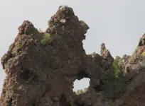
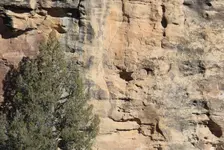
Okay, I will attempt to attach a pic of what I believe is an Alpha monument that is somewhat close to the boulder I refered to in my last post. Notice the shape of the face, with what appears to be a backpack of some sort on its shoulders. The "hoyo" is quite large and I haven't been able to sight it yet due to the precariousness of its location on the cliff face. So what do you think?
 

Attachments

  • alpha.jpg
    alpha.jpg
    142.3 KB · Views: 1,520
Looks like a classic deposit of wind- and water-eroded conglomerate to me. The matrix appears fairly soft and probably collapses quickly at the exposed surfaces, leaving the hackly edges. If you're going to chisel a permanent marker, you certainly would not use this stuff.
 

Hmm.it is true this is really rotten rock..but think redundancy. I've seen some "confirming" markers in some pretty lose matrix before. It was a big surprise..I will admit. Took me a long while to accept it, even though the proof was before my eyes..so to speak. You need to be careful on that because nature makes tempting shapes in the areas Spanish traveled. So, look for the more concrete ones....

Not all holes in rock are meant to be looked through so do not sweat that. It could just be an indicator of an inbound trail meant to be seen from a distance. It reminds me of a trail monument I saw, bird beak pointing the way and a nice hole in it, on cross angle. In that case I went the way the bird head was facing and that was the trail. With big monuments like that, in my own limited experience, they are not generally meant to be looked through if there is no path to the hole. I could be wrong on that. Could it be some rock climbers ascended this? Looks like a clip at the top...but it does not seem the usual fare for rock climbers...too rotten.

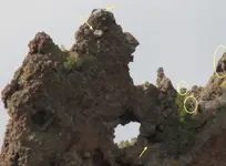
There are enough odd rocks and shadows of a more firm nature around to make me think..yes that is a couple of birds - a big and just possibly a little one. So follow the line of site of the big bird's beak (or perhaps it is a pack animal) and it looks like it points to some interesting things. The smaller perched bird, if it is a bird, looks in another direction, and would be worthwhile to check out too..that is if it is a bird.

Based on the context, I would say yes...it is Spanish. I've marked out only a few of the possibilities that to me make me think it is artificially modified.

I would look around for local information too, given it may be on a trail near water.


Woot!
Best of luck in your journey.
 

Attachments

  • alphamk.jpg
    alphamk.jpg
    76.7 KB · Views: 2,189
Looks like a classic deposit of wind- and water-eroded conglomerate to me. The matrix appears fairly soft and probably collapses quickly at the exposed surfaces, leaving the hackly edges. If you're going to chisel a permanent marker, you certainly would not use this stuff.

only SOMETIMES spingfield....
, some of this conglomerate is super hard, so hard they call it"cemented" the 49ers found this stuff and some of it was gold bearing and "drifted' into it with tunnels, so hard it need no timbers for support~! AND when they found a lot of this cemented material, they ran it thru the rock crushers that normally was used for Quartz bearing gold ore~!!
In fact I have three awesome conglomerate monuments that include a Sphinx, a mushroom and an elephant, all perfectly intact and accurate after a century or two...

So Sanguine, follow this trail marker carefully, as there will be many twists and turns...and that hole or hoyo...kenworthy calls it the object of the trail...the MINE or CACHE~! do not be dissuaded, either innocently or on purpose, you have an authentic trail marker, perfectly executed in the classic colonial spanish code maker fashion...follow carefully and take lots of pics, post any markers or signs you feel revlant or ones you want decoded...as the code has been broken, no landmarks, we don't need to know where or what state or anything, as the code is all the same all over "new spain"..good luck and welcome to the forum - some of us are here to help you..no strings...cool huh~!

Actually this looks like a composition of two of Kenwothys classic trail signs, the pack back caring 'peon' as he called them and the large bird...a trail marker meaning that many twists, turns and changes of direction are ahead, if you follow this trail sign...the hoyo just tells you that this is not wind erosion at all [confirmation]and is in fact man manipulated.. check kenworthys book, spanish trail signs and monuments, out of print now and a collectors item [check with local library]as it contains so much valuable information it went from a $18 msrp to $180. on ebay~!!

rangler
 

I got a brand spanking new copyof Spanish Monuments and trailmarkers to Treasure in the US by Kentworthy on Ebay for $20 bucks. I think this week, I'll buy another one of his books on Ebay.
 

I got my copy of Mr. Keyes' book on Amazon for $14 plus shipping from one dealer.
Another dealer had a copy he wanted OVER $600 for..........Yep, six zero zero.

So, sanguine, shop around and you'll find a decent price on ALL of Kenworthy's books. :thumbsup:
 

Shortstack said:
.....So, sanguine, shop around and you'll find a decent price on ALL of Kenworthy's books. :thumbsup:

If you get in a bind, I might part with any of mine you may need for $180 $600 each.
 

:hello2: What a response! Thank you all.

Shortstack- Thanks for the advice on both fronts, that is a great idea about the geneaology research I will have to remember that.

Desertmoons- Wow! is all I can say , you are a very intuitive person. You will see what I mean coming up in the following posts from me:)
Also thanks for the encouragement and advice.

Springfield- That is a very astute observation about the type of material the monument is made up of. That is precisely what I thought when I first noticed it as well, until I examined the material more closely. It is in fact a very hard concretion that is suprisingly strong. I think I will pass on the book offer though, too rich for my blood as of yet... lol.

Rangler- I was hoping for your input on this monument. I own the Kenworthy book you spoke about, and as a matter of fact in reference the "peon with the backpack" looked quite similar to me as well. I will make sure to figure out a way to get up there and sight check that "hoyo" the next time I am on site.

Thanks again everyone! :notworthy:
 

Greetings Everyone!

While hoping to keep in the spirit of learning, and Old Dog's intention of this post. I will submit more signs that I have located in the area I have been working in. Some of these symbols I know a bit about, while others I am not too sure of at all. I would sure appreciate any help, or advice for that matter concerning them.
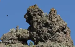
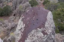
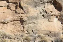
This first picture is of the alpha monument traveling in the opposite direction (WEST) of the cliff face. The picture in my other prior post was from the EASTWARD direction. Does it convey the same info? Which side should I use to sight with? Both? By following the nose of the monument I came upon the group of symbols approximately 30 to 40 yardsfurther on, as shown in the second picture. It appears to be a pecked out t letter B with a v converging into the two lobes of the letter. Now if what I remember from reading some of the other posts is correct the B can have multiple meanings such as: B=2, or B can also be the number 13 pushed together to appear as the letter. The incorporated v mark I am not sure of at all. Also notice the small scratches of symbols on the right side of the rock. They definitely were not placed there with as much effort as the other sign. The upper is what appears to be a z with two vertical lines passing through it?? And the lower appears to me to be a square with a oval shape marked inside.(meaning cache? :dontknow:) Feel free to mark up the photos as you see fit everyone. Thanks in advance :read2:
 

Attachments

  • otherway.jpg
    otherway.jpg
    91.9 KB · Views: 2,164
  • 1stgroup1.jpg
    1stgroup1.jpg
    178.2 KB · Views: 2,249
desertmoons said:
One thing i really enjoyed about this thread was the level of maturity and good will in it. Everyone welcome to their opinion and polite adult discourse the norm.

Shall we keep it that way? Or shall the thread go away...


I deleted the first picture I had here....it was the wrong one.

Speaking of horses...here is one of my favorites, rider included.

Anyone else got a horse to post?
Hey guys.............

The Horse Soldier is prominent at face value, all throughout the USA; trails running in any direction where the first treasures come into scope. The first thought here should be the presence of water of which the horse and rider requires above all; the greatest of finds out there. Once acquired, the other hunts may begin. The form in your photo of which is of course repeated all along the trails, refers to other animals as well wherein their forms are similar on one scale or another.

Of course the burro would be next; a sure footed creature, able to reach beyond the ponies in rough terrain and capable of seeking out somewhat invisible or ancient trails once forgotten by men. Where there is spring water or ancient sign of it present in stone, there is obvious hydrothermal activity and here one will usually locate the required rabbit trail of miner's markers running to and fro. The same head profiles in your photo may also refer to Draco the winged one who is partial to hydrothermal cave-like formations. Many of these are rough beyond the reach of four legged animals and the picture as such would point you to an exact high place of which one may in-vision the end of the trail once used by the miner's burros. There a bare spot of beaten ground may still show (photos from the air). The mine or treasure as such should be within a stone's throw of said ancient trail's end.

Another Horse and burro included here.......... code? what code? you mean cartoon? shapes on land, shapes in hand. Seek out the French curve as it is the naturally mapped form and base shape leading in to the finds; an elongated S, similar to an executioner's blade of sorts. The cutoff.....

The miners were quick to choose active main animal trails leading in and out of water sources as the travel of local wildlife would cover their tracks to the mine; and this on a daily basis. One can almost bet that a little footpath can still be found, leading over into the colors and quartz we seek. Nature in repeating itself, may have provided you with a somewhat natural sky map of sorts, this stone chosen for that reason. Seek out similarities. Cartoon characters existed long before Walt Disney. Their graphic flexibility provided entertainment similar to charades, whilst they traveled the long and dusty trails of the horse soldier; like picking out forms in the clouds. :coffee2:

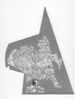
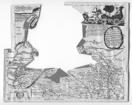
Utah county and surroundings; all of the purest metal mines most accurately drawn in position from each other, on various scales of cartoon reference. Dot to dot, water to water and where it's not. This map maker worked for the Jesuits under cover. There were already plenty of other maps drawn of Utah and this one was a fanfare prop; in reality they were working under cover and re-securing a record of the Jesuit holds of ancient Aztec mines and Kivas of which they acquired from the local natives over a period of a couple of hundred years.
 

Attachments

  • MasterMapInsert.gif
    MasterMapInsert.gif
    460.2 KB · Views: 1,825
  • MieraMasterMap.gif
    MieraMasterMap.gif
    516 KB · Views: 1,812
sanguine said:
Greetings Everyone!

While hoping to keep in the spirit of learning, and Old Dog's intention of this post. I will submit more signs that I have located in the area I have been working in. Some of these symbols I know a bit about, while others I am not too sure of at all. I would sure appreciate any help, or advice for that matter concerning them.
This first picture is of the alpha monument traveling in the opposite direction (WEST) of the cliff face. The picture in my other prior post was from the EASTWARD direction. Does it convey the same info? Which side should I use to sight with? Both? By following the nose of the monument I came upon the group of symbols approximately 30 to 40 yardsfurther on, as shown in the second picture. It appears to be a pecked out t letter B with a v converging into the two lobes of the letter. Now if what I remember from reading some of the other posts is correct the B can have multiple meanings such as: B=2, or B can also be the number 13 pushed together to appear as the letter. The incorporated v mark I am not sure of at all. Also notice the small scratches of symbols on the right side of the rock. They definitely were not placed there with as much effort as the other sign. The upper is what appears to be a z with two vertical lines passing through it?? And the lower appears to me to be a square with a oval shape marked inside.(meaning cache? :dontknow:) Feel free to mark up the photos as you see fit everyone. Thanks in advance :read2:
At face value, your looking at the profile of a Don, 32 degree Mason, Ship Captain, Military Captain, a giant of a man, a traveler; one of landmark proportions amongst all others. His parrot sits on his shoulder with wings spread in excitement as they return and come near to an existing perch, not far from the mine or hold. Smaller and smaller headstone combinations will be found along the way from this giant on down to palm size stones of similar form and character. The smallest set(s) will be found surrounding the hidden dig. Look for the quartz in purple or the next best similarities.
 

Thanks Twisted,

I'd always considered that horse rock purely local information but when I look and think about it from a larger perspective it has possibilities too.

Water is to the left, in fact a campground. Going on that way eventually you hit a mine trail though the mine is not in a direct line. The mine trail is very well marked as far along as I've gotten on it. I'll have to go back and look for similar shapes along the trail and in that area and topo style generally.
 

Great info on the horses guys, I love this thread.

Thank you Twisted Fork, I can see the Don and his parrot now that you pointed it out, thats amazing! I am not sure of how you gleaned the other info,
as I am new to this but what a fascinating description.

DM- You were so right on with regards to following the face, there was a marked boulder 30 yards up the slope. I submitted the picture a few posts back. And there is a nice spring within 200 yards, opposite of the direction the alpha is facing. I was also looking over your mark up of my photo and saw most of what you were referring to, you have a keen eye ( I'm a bit jealous) but I am trying to learn. :thumbsup:
Oh.. and also this is a major trail branching off of the the main trail itself ( within a mile or two). I believe they used it as a pass around the south side of a mountain range during foul weather? ( Not sure..)

Also a question. I have more pictures to share, but I don't want to detract from this thread as I am a novice. Should I create my own and ask for help?, or feel it out here?
I just dont want to bog things down for everyone if I can avoid it. : ???

Regards,

Sanguine
 

Some of the pics I've put up were rather poor quality.
Wanted to share one that is fairly clear.
One of my favorites.
 

Attachments

  • IMG_3362.jpg4.jpg
    IMG_3362.jpg4.jpg
    122.1 KB · Views: 1,530
  • IMG_3362.jpg2.jpg
    IMG_3362.jpg2.jpg
    215.1 KB · Views: 1,575
Shortstack said:
I got my copy of Mr. Keyes' book on Amazon for $14 plus shipping from one dealer.
Another dealer had a copy he wanted OVER $600 for..........Yep, six zero zero.

So, sanguine, shop around and you'll find a decent price on ALL of Kenworthy's books. :thumbsup:


WoW. I would let mine go for $ 350.00!! NE Takers? LOL :headbang:

Really the place to look for deals on New and Used books
http://www.alibris.com/ I have found bargins there
 

Hello all,
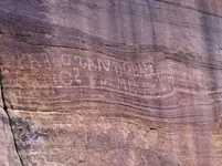
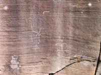
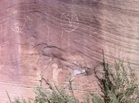
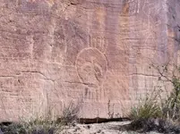
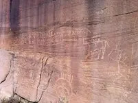
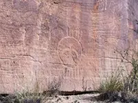
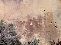
I have been lurking for awhile. This is a great forum. I have learned so much from this thread alone. I am looking at rocks and ridges different know. I thought I would throw up some pictures to see what you all thought. Was not sure if these have any significant reason or just some old sheepherder from the early 1900s. Some are native but the backwards "S"s and the saddle on the horse made me wonder. The one that looks like a face could be something else like a map? Thanks John T
 

Attachments

  • IMG_0295_1 (2).JPG
    IMG_0295_1 (2).JPG
    183.9 KB · Views: 1,634
  • IMG_0295_1 (3).JPG
    IMG_0295_1 (3).JPG
    304 KB · Views: 1,715
  • IMG_0295_1 (4).JPG
    IMG_0295_1 (4).JPG
    275 KB · Views: 1,791
  • IMG_0295_1 (5).JPG
    IMG_0295_1 (5).JPG
    193.2 KB · Views: 1,796
  • IMG_0295_1 (6).JPG
    IMG_0295_1 (6).JPG
    227.3 KB · Views: 1,885
  • IMG_0295_1 (7).JPG
    IMG_0295_1 (7).JPG
    194.6 KB · Views: 1,878
  • IMG_0295_1.JPG
    IMG_0295_1.JPG
    204.4 KB · Views: 1,890

Top Member Reactions

Users who are viewing this thread

Back
Top