Want to try Dowsing?

Red desert

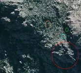
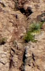
Speaking about the lost Dutchman's mine . I will post an aerial picture of the region where I believe is the LDM . This region has some of the Dutchman's mine clues, like : The horse head rock ( red ) , the three pines ( orange ) , the roofless two room house ( blue ) in a cave's mouth ( green ) . The cave is not able to be recognized in this picture , but if you want i can post a real picture where could be recognized .
I believe in this region could be another two mines , except the LDM .
Can you " see " something in this picture ? Thank you in advance .

LDM.jpg
 

A retired Ph D scientist sent me tons of research info and all the known maps related to the Lost Dutchman. The biggest problem would be getting to the site to check things out. I know of one map source that had the old topo with a crossed pick and shovel on the map. I don't know if it's true, but someone told me the Forest Service made sure it was removed from maps so people aren't going to search for it. People still search and the map only showed the location for the one shaft found now all worked out.
 

Just realized my dowsed LDM maps were in my old computer running WXP that crashed. Don't really need them, know the area well. The old emails keep online in folders but could take time to locate. Now I need to make new pins in GE because started the project when using GE in old computer. Good thing I looked, might be smart to recover them.
 

Looked at your map for a moment, you are so close to the Lost Jesuit Treasure. Toss a rock to the SW and you'll probably hit the site.
 

Looked at your map for a moment, you are so close to the Lost Jesuit Treasure. Toss a rock to the SW and you'll probably hit the site.

Red desert

Thank you for your interest of my picture/map . You meant the SW of the picture because in reality the north is down .
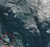
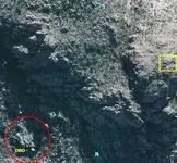
So , you have mentioned the " turtle " shape . IMO this spot is recognized in an alleged Waltz's map with the word " ORO " beside the " turtle " shape . I supposed to be a Waltz's cache .
I post a larger picture of the same region . can you mark the spot ?

picture.jpg
 

Yes, I did mean SW of the map you posted. But since the map is not oriented to true N, it probably isn't the same location. There are a lot of holes and what looks like in GE to be a cave. This would be the area to the NE of my pin. Now, I found the piece of paper with the pin coordinates written down. When I checked the folder in my GE made for the Lost Dutchman pins, it was empty. The reason why, the pins were set up in my old computer running WXP. Before it had crashed completely, wrote down coordinates for this pin only. Apparently, I never got the new pins made and lucky the paper with the coordinates didn't get lost or thrown away. I will get the pin set up in my new laptop ASAP.
 

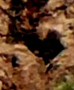
The pin is not on the suspected Lost Jesuit Treasure, only used as a reference point to locate the heart on a shaft carving. The bottom of the shaft carving rests on top of a king's crown carving the size of a miner's rock house.
 

Attachments

  • heartshaft1.jpg
    heartshaft1.jpg
    134.2 KB · Views: 83
  • heartshaft2.jpg
    heartshaft2.jpg
    115.5 KB · Views: 87
  • heartshaft3.jpg
    heartshaft3.jpg
    104.7 KB · Views: 69
So , the " ORO " is in the place where you " saw " the cache .
Maybe you didn't see the spot in the yellow square . Is the place where I believe how the trail from the stone tablets ends .
I use also the WinXP Pro at least 12 years without problems . I only upgraded my PC hardware

picture.jpg.
 

Last edited:
Well, I used my WXP way too much, lasted longer than I had expected. Yes, this map does look familiar. One of my pins that got lost in my old computer looks a lot like your map. I put a pin there because of the gold signals and the retired Ph D scientist confirmed the site is in the alteration zone which produced the Superstition veins.
 

In fact, that trench looking cut running up from the bottom right corner really seems familiar now. Of course, there are a lot of similar places in the desert......after a while everything does and why people get lost so easy. Best way is to ask a couple question.

1. Is there canyon to the west and south?
2. If not is there canyon to the south and east?
3. If none of the above, is there canyon or a bend to the south?
5. Is there a bend of canyon to the southwest?
 

:icon_scratch: ??? I put the coordinates in GE and it came up Black Top Mesa, must have copied the coordinates from the wrong map.
No problem, have 3 folders with the important dowsing emails saved......except there are so many to sort through, but already found maps for a couple of the pins.

No way to tell visually about the map, everything in GE is much the same for this area. Really need to get all my GE pins back to know how far to zoom in and out.
 

In fact, that trench looking cut running up from the bottom right corner really seems familiar now. Of course, there are a lot of similar places in the desert......after a while everything does and why people get lost so easy. Best way is to ask a couple question.

1. Is there canyon to the west and south?
2. If not is there canyon to the south and east?
3. If none of the above, is there canyon or a bend to the south?
5. Is there a bend of canyon to the southwest?

First the picture is not a GE image but a Bing map image .The trench which you have mentioned is the " gulch " from the Dutchman's clues .
Bicknell wrote : " In a gulch in the Superstition Mountains, the location of which is described certain landmarks; there is a two-room house in the mouth of a cave on the side of the slope near the gulch..... " . The clues from my picture are accurate .
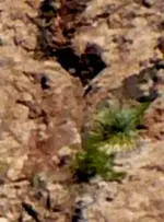
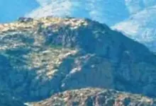
I post a real picture from the site to see the cave . IMO , this cave is the CASA CAVERNA from some Spanish maps and in the Latin stone heart is recognized as TRANSEO ECCLESIA maybe because the big cross which is at the left of the cave . In this picture you can see also the FORNIX ( arch ) from the Latin heart .

picture 2.jpg

and now to answer to your question :

1) No
2) No
3) No
4) No
 

So , the " ORO " is in the place where you " saw " the cache .
Maybe you didn't see the spot in the yellow square . Is the place where I believe how the trail from the stone tablets ends .
I use also the WinXP Pro at least 12 years without problems . I only upgraded my PC hardware

View attachment 1287859.
====================================
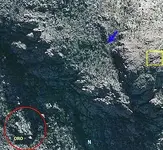
This is the only gold treasure in this map (where the blue arrow points).. it is man-made gold.. statutes weighing around 40kgs in an iron container, ALSO another iron container containing man-made gold bars, gold coins and gold necklace, but this 2nd container weighs 200kgs..
I don't know their culture in that part of the world.. it is in a vacuum with air inside (not buried), 5 dead bodies around it (also not buried), I don't know, is it a burial room?? Like I said I don't know their culture.. but the older one is laid down opposite to remaining four bodies, his head heading north, however the other 4 bodies are laid down beside each other but their heads are heading south.
Anyway, vertical depth to gold: around 3 meters deep..
P.S : No "evil magic" is involved in this culture's burial rituals..
 

Attachments

  • treasure1.jpg
    treasure1.jpg
    45 KB · Views: 164
Last edited:
elhit29

Fantastic ! Thank you .

Your input gives a new twist in the Sombrero mine legend in relation with Jacob Waltz , aka " the Dutchman " . I wrote Sombrero and not LDM because are two different mines but very close each other . The Sombrero was a Peralta's mine and was the first which Waltz found and worked with his partner and friend Jacob Wieser . The story goes ( from the Waltz 's death bed confession ) how when they first found the mine with the directions got from Peralta's relatives , the mine was worked by five Mexicans miners who Waltz and Weiser shot them in few minutes . After shot them they carried the Mexicans bodies in the mine .
So , the gold from the containers that you "saw " could be the Mexicans smelted gold which they have mined from the Sombrero mine . Maybe the containers were hiden behind a wall or rock and Waltz didn't see them . After they put the Mexicans bodies in the depth of the tunnel , maybe they builded a wall from rocks creating a small cavity/vacuum . Forgot to say how the Sombrero mine is in a boot shape ( from John Reed's description ) so the depth of the tunnel could be what you have mentioned as vacuum . Or all the closed mine itself could be considered like a vacuum .
Waltz didn't work this mine for long time , and after covered it well , worked an outcropping with rich gold ore which later became the LDM .
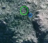
I post a closer view of the region . With green is the region of the Sombrero mine's shaft and with blue is what you have pointed .

spot.jpg
 

Last edited:
Well, the green area you marked is a mine shaft.. my point is the only treasure man-made gold in the whole map.. the 5 bodies were not shot.. this is a fact..
 

Well, the green area you marked is a mine shaft.. my point is the only treasure man-made gold in the whole map.. the 5 bodies were not shot.. this is a fact..

Then , they could died of asphixia when the mine collapsed and closed them inside at the depth of the tunnel . Would be another unknown story . Or could be another cave with another entrance . Remains to see .
 

Then , they could died of asphixia when the mine collapsed and closed them inside at the depth of the tunnel . Would be another unknown story . Or could be another cave with another entrance . Remains to see .

No traces of bullets or firearms..why do they have one container of gold statutes?? Where did they get it from??
 

Top Member Reactions

Users who are viewing this thread

Back
Top