Video 4 - The Peralta Stone Maps with Frank Augustine

Wayne,

In your opinion, are these kinds of ruts, in rock, made by wagon/truck wheels?

Take care,

Joe

Joe:

My opinion would vary, depending on what I was looking at.
Most iron rimed wagon rims are only 2-3" wide, so the ruts they form with repeated passage are narrow.
How far apart the ruts are might indicate a large wagon or something smaller., and the worn area in between can indicate whether a single animal or team was used to draw the conveyance. How deep they are and where they are might indicate the reason they are in a certain place.
Trucks or other modern vehicles like 4 x 4's and ATV's on the other hand, form much wider ruts, as well as leaving behind gouges, scrapes, body paint and rubber behind. Sometimes a few parts as well. Lots of that out there. And if, like on the ranch roads I mentioned, there has been heavy motorized vehicle traffic in modern times, it's unlikely anything would remain of older wagon tracks.

Hope that answers your question.

Regards:Wayne
 

Yes they can, especially where the same path is or has to be followed, like one between rock outcroppings.
There are a few places out there where such ruts and cuts have been found and photographed <cut>

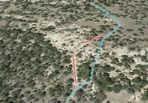
Confession time: I don't believe wagon traffic formed the ruts shown in Post #761. It appears that they were extant before the road was built that would include them. The road was used by wood haul wagons for Fort Bayard NM in the 1800s. The road meanders on fairly mild terrain - through grassy meadows, around trees and over flat, easy rock shelves. Then the road inexplicably veers over and up to a gnarly, high point where the ruts are, then returns to the more sensible route. Don't know why - maybe for laughs? The alternate route shown on the photo below is a much better choice for the wagons - easy, flat rock shelf, steady grade and some trees that could have been removed.

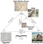
Of more interest is the fact that these ruts were apparently constructed as a waypoint or map node exactly on a line between two very distinct and well-known landmarks, more than ten miles apart. That line itself is one leg of a near perfect 90-45-45 triangle spread out over 50 square miles, all line-of-sight between the three corners - the two mentioned above and the third being a very weird petroglyph panel containing ankhs and other symbols. Maybe sometimes things aren't what they seem to be. Go figure.

ruts.jpg
 

Last edited:
Interesting detour to high ground.
An observation point to check traffic and goins on all directions perhaps. Or a defensive position, signal station, campsite.
Seems to sure have been a waypoint.
 

Heavy wagons can create deep ruts.

View attachment 1178121

Yes they can, especially where the same path is or has to be followed, like one between rock outcroppings.
There are a few places out there where such ruts and cuts have been found and photographed.
The ones I and a very few others have found most interesting, are the ones much narrower than those common near immigrant trails and mining haul roads.
While noticeable, they are never as deeply cut into the rock like those in your photo.

Nothing to confess. Unless your comment and photo was intended to be misleading.
Seemed clear and simple enough to me though, so I answered it in my first sentence.

As to what seems your belief that the deep "rut" in your photo is some kind of sight line or ? , the idea of such large man made carvings of solid rock ( as a component of a waybill or map to treasure) doesn't hold much appeal for me. Not saying it can't be, and there are certainly much older examples of ramps, water channels and such world wide. Cart and wagon tracks as well, and it's also possible that these noticeable and notable pre-existing features could have been shown on some old maps.
Trails don't always follow what would be the easiest route in the now, but the easiest route then.
Back when the first wagons or carts blazed many trails, even a steeper path over solid and uneven rock may have been easier than through the trees of a grove or a soft area, where getting bogged down might be a greater threat. Once they found they could do it, they didn't even think of trying to find another way, or of cutting their way through and burning out the stumps. No matter how few they might be.

Regards:SH.
 

Last edited:
Wayne,

Tom's picture is what a well worn wagon road should look like.

Take care,

Joe

All three pictures, Joe....as a matter of fact. Since they are all of different sections of wagon road. Globe to Mesa and Pinal roads.
So no disagreement with that interpretation.
But none are like the "not well worn" and "not a wagon road" which I eventually settled on as being the trail I was looking for.


Regards:Wayne
 

As to what seems your belief that the deep "rut" in your photo is some kind of sight line or ?

Oh, it's a no-brainer.

See exhibit below. First you establish the big right triangle. The Nun is an easy starting point, but you have to work for the other two corners. The big cross is in a tough place, but it's easy to find once you're there. The Egyptian carvings are only found by intuition or, in my case, because someone directed me there. They're very subtle. Then you pick a spot on the NE line and follow the 315° azimuth until you reach the ruts. Now turn 90° left and follow that bearing (225° - the same bearing as the ruts themselves!) until you find the Pictured Rock panel. This panel is also exactly on the line that bisects the big triangle - confirmation that you may now proceed with the information provided on the Pictured Rock panel. The "ruts" were quite beneficial, and in exactly the right location - like a talisman that the augurs used when laying out their templums in the old days.

You could call it all coincidental, but I don't believe in coincidences myself. I was very fortunate being able to discover and confirm this geometry and its components - it would have been impossible for me without GPS and AutoCAD. Of course, an old-fashioned compass and map is handy too.

triangle.JPG
 

Last edited:
Sorry sdc, but your remark "high ground" is self explnitory. wet weather. That is fairly common down here, in wet weather they use the high ground, in dry the more direct low land route.
 

Last edited:
Sorry sdc, but your remark "high ground" is self explnitory. wet weather. That is fairly common down here, in wet weather they use the high ground, in dry the more direct low land route.

I know it's self-explanatory - there's no reason for the road to detour over onto those ruts. The route to the directional change is essentially all downhill at about 3% uniform grade for about a half mile. Just a gradual fall. No crossings, no clay patches, no dips. Nothing but sheet flow if it rains enough. The ruts are all by themselves on an outcropping a couple-three feet higher than the ground around them. Up onto the rocks for a moment, then back down. No good reason. I think the soldiers used it out of boredom - like a "wham, bam, thank you ma'am" berm that ATVers like to go over.

Anyway, the road usage in that vicinity is a moot point in the bigger picture of things. Don't get side-tracked.
 

Last edited:
All three pictures, Joe....as a matter of fact. Since they are all of different sections of wagon road. Globe to Mesa and Pinal roads.
So no disagreement with that interpretation.
But none are like the "not well worn" and "not a wagon road" which I eventually settled on as being the trail I was looking for.


Regards:Wayne

Wayne,

What I should have said: Tom's picture is what a well worn wagon road should look like........in bedrock.

Take care,

Joe
 

This panel is also exactly on the line that bisects the big triangle - confirmation that you may now proceed with the information provided on the Pictured Rock panel.

I'd like to help keep this conversation on topic, so with that in mind I'll ask the following questions.

(A) If, in your case, you had stumbled upon the "picture rock" first, and since it has the information you need to proceed from that point, would this make the other four places redundant ?

(B) Assuming that you took a full set of photos, and/or made an accurate drawing of this rock, why not share one or both with the rest of us ?

(C) If you should do so, how can we be sure the photos or drawing haven't been altered in some way ?
 

ImageUploadedByTreasureNet.com1435017908.746097.jpg

This is part of the Butterfield Stage Route. Tracks are very close together and well worn grooves starting at the base of the mountain pass. ImageUploadedByTreasureNet.com1435018031.105875.jpg

Much different in the rocky terrain out by you, but very similar when it starts to ascend into the Mountains on the far side of the picture.
 

Wayne,

What I should have said: Tom's picture is what a well worn wagon road should look like........in bedrock.

Take care,

Joe

Joe:

"Heavy wagons can create deep ruts."

"Yes they can, especially where the same path is or has to be followed, like one between rock outcroppings.
"There are a few places out there where such ruts and cuts have been found and photographed."

"While noticeable, they are never as deeply cut into the rock "


"who's on first !"
icon_thumright.gif


"bedrock"


Last edited:
A search using "Wagon ruts" brings up plenty of good examples. Or "Cart Tracks in Rock" etc.
I've been to some of these places, and both hiked and driven a Ford Clubwagon and camper on over 90 ungraded and unpaved miles of the Oregon Trail in S. WY.
 

Last edited:
I'd like to help keep this conversation on topic, so with that in mind I'll ask the following questions.

(A) If, in your case, you had stumbled upon the "picture rock" first, and since it has the information you need to proceed from that point, would this make the other four places redundant ?

(B) Assuming that you took a full set of photos, and/or made an accurate drawing of this rock, why not share one or both with the rest of us ?

(C) If you should do so, how can we be sure the photos or drawing haven't been altered in some way ?

A) That's a solid question. Thus far, it appears that the geometry here is fractal, resulting in a situation where one piece of data cannot trump the whole. What is found on the panel appears to require the use of information available at other places, including a couple of the four.

B) Of course I have a full set of photos. However, I agree that we need to move this thread back on topic, and it's inappropriate to keep following this tangent here. I posted what I did merely to point out to people that things are often not what they seem to be. I've published all these photos and more elsewhere. Those interested can probably find it on their own or pm me.

C) You can't be sure of that unless you verify it for yourself. Or you can trust me. Ha ha.
 

This is part of the Butterfield Stage Route. Tracks are very close together and well worn grooves starting at the base of the mountain pass.

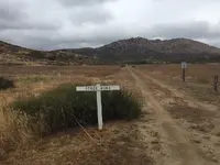
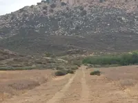
More of the Butterfield Trail, in Cookes Canyon NM - still in good shape after 150 years. Yes, that's a grave on the side of the road - one of 400 killed by Apaches in this six or eight mile stretch. Buried where they fell.

Pass grave 1.JPG
 

Top Member Reactions

Users who are viewing this thread

Back
Top