Video 4 - The Peralta Stone Maps with Frank Augustine

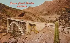
Also - just for point of conversation - when you type "Queen Creek Bridge" into Google - this is the bridge that brings the majority of results. Its about 20-ish miles away from the tumlinson site and doesn't correspond to the Tumlinson Map.

2 totally different locations.

azroute70pc052.jpg
 

Also - just for point of conversation - when you type "Queen Creek Bridge" into Google - this is the bridge that brings the majority of results. Its about 20-ish miles away from the tumlinson site and doesn't correspond to the Tumlinson Map.

2 totally different locations.

Ryan,

That is the Superior QC bridge, between Superior and Miami.

The bridge that we've all been discussing, is the QC bridge at Florence Junction.

Should come up with a simple way to label it- to save confusion.
 

Ryan,

That is the Superior QC bridge, between Superior and Miami.

The bridge that we've all been discussing, is the QC bridge at Florence Junction.

Should come up with a simple way to label it- to save confusion.

Agreed - the reason I posted the "other" queen creek bridge is because I am getting quite a few emails from folks here on T-Net talking about it. Rather than reply to each one - easier to post in the thread.

People are getting confused.
 

i am just curious why all you so called experieced salty know it all dutch hunters think it is important to find out where the stones were supposedly found? i mean do you really think the dude is going to say exactly where he found them? how many people post the locations of their awesome metal detector finds with gps coordinates?very few if any at all? i dont metal detect ( well other than my harbor freight job)so have never found myself in that position.. so whats the deal on the supposed location? another thing... i will say the maps are real, they are old, and they pertain to a very very small area. 1/4 mile squared. funny i found the area my 5th time out lol. didnt waste a lifetime looking for it.. uhhum..i mean spend a lifetime looking for it. have fun and maybe i will run into one of ya out there. just listen for the pic hitting the quartz. god bless you all for all the info on here.
 

i am just curious why all you so called experieced salty know it all dutch hunters think it is important to find out where the stones were supposedly found? i mean do you really think the dude is going to say exactly where he found them? how many people post the locations of their awesome metal detector finds with gps coordinates?very few if any at all? i dont metal detect ( well other than my harbor freight job)so have never found myself in that position.. so whats the deal on the supposed location? another thing... i will say the maps are real, they are old, and they pertain to a very very small area. 1/4 mile squared. funny i found the area my 5th time out lol. didnt waste a lifetime looking for it.. uhhum..i mean spend a lifetime looking for it. have fun and maybe i will run into one of ya out there. just listen for the pic hitting the quartz. god bless you all for all the info on here.

As I understand it, the reason the location is important is a matter of 1) Historic Significance, and 2) all of the stones have not been discovered as there is supposed knowledge of a 5th stone.
On a side note, it's great that you have located the area and are confident that you didn't "waste" or "spend" a lifetime looking for it...sometimes more than anything else, it's the thrill of the hunt and the knowledge that is obtained while doing so.
Tina
 

Hiker,

You sing a strong argument. The area is pot holed from searchers. But Tumlinson himself said it was a sandy area not full of hard stones like that area off the NE side of the bridge where those holes are Ryan and Frank shot in the video.

I searched all over that pot holed area and decided the ground was to rough and hard for any stone map to have survived the burial with out severe damage. So your stating the Magazine showing the other bridge from the Marlowe's article is a lie or just a fabricated misconception?

Travis was after all trying to get closer to the mountains he had read about for a peak at a peak.

Being that close to the bridge would have made the area traveled heavy with road equipment for the construction of the bridge. Someone said that the maps had been dug up during the making of the second bridge but then again the maps would have been messed up bad from the equipment when digging.


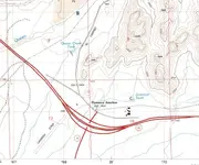
This is from a 1966 topo:

View attachment 1168403

And 1900:
only wagon trails back then...

View attachment 1168404
 

Here is a close up of the 1966 topo.

florence junction 1966 close up.jpg

If I am in the area this weekend I will go take a few pics of the old silver king mine road bridge, and see if I can check the ground for classification of material.
This is the bridge by Black point,the one on the west side of Queen Valley.
I thought I read somewhere about the stones having something to do with Black Point.
 

Last edited:
As I understand it, the reason the location is important is a matter of 1) Historic Significance, and 2) all of the stones have not been discovered as there is supposed knowledge of a 5th stone.
On a side note, it's great that you have located the area and are confident that you didn't "waste" or "spend" a lifetime looking for it...sometimes more than anything else, it's the thrill of the hunt and the knowledge that is obtained while doing so.
Tina
when the date is right i will post my finds from said map against others on here. we shall see who has the knowledge and who doesnt.only when the date and the time are aligned will i let you see. father forgive them for they know not what they do.
 

when the date is right i will post my finds from said map against others on here. we shall see who has the knowledge and who doesnt.only when the date and the time are aligned will i let you see. father forgive them for they know not what they do.

Alrighty then! Wait...What???
 

As I understand it, the reason the location is important is a matter of 1) Historic Significance, and 2) all of the stones have not been discovered as there is supposed knowledge of a 5th stone.
On a side note, it's great that you have located the area and are confident that you didn't "waste" or "spend" a lifetime looking for it...sometimes more than anything else, it's the thrill of the hunt and the knowledge that is obtained while doing so.
Tina

Howdy DiggerGal,

Yes the historical significance is important because they are real. The fact that they were not discovered by an archie made their authenticity questionable, together with the fact that they could not solve them. These facts however are irrelevant to their authenticity. There are facts that lean towards their authenticity, like the eyewitnesses who saw roots in the groves when Travis took them to clean them off. The truth is shrouded by those who label them as fakes, but every effort to prove them fake has fallen short.

The location of the PSM's discovery site had not been lost, it has been recorded on Golloms website, and more extensively by Somehiker, and Cubfan, and even Al Reser before them. How do you think Frank and Ryan found the place?

As for the fifth stone, there is none. The PSM's consist of only four stones, that is written in stone, the Priest stone that is. On the instructions to dig in the same hole, the heart is the fourth, and last stone. The PSM's have been copied before, and after their discovery. Some who can't solve them have assumed there are more stones. There is no secret knowledge of a fifth stone, that is just based on assumptions, and lies. The letter from Robert Tumlinson to Garman talks about five stones, but that fifth stone is not part of the PSM's, nor did Robert go back to the area and uncovered it himself. From what I make of Robert Tumlinson's stories, he was not really with Travis when Travis uncovered the PSM's. The discovery area was recorded thanks to Charlie Miller who was a friend of Travis. The discovery area that Robert claimed was near Black Point by the camino viejo. This was the area Robert, and his drunk freinds thought Travis was referring to.

Those three amigos, or three Bobs, (Tumlinson, Garman, and Ward) seem to be responsible for a lot of confusion.

Homar
 

Homar I think I would put more faith in a letter from Robert T as to how many stones were found. Perhaps they hung onto the key stone for the maps.
 

I found this site rather interesting.

Arizona Memory Project

Numerous Photos of Queen Creek Bridge construction, some are the Superior Crossing while others are the Florence Junction area. I believe they include both the 1920 bridge and the later bridge (About 1935) (there are no hard dates for most of the photos, anyway dates that I trust completely :))

I have not yet tried to sort them out as some of the information appears to be garbled.

The photo previously posted by Old is included.

I would welcome any insights.

Garry
 

Hi RG:

The first time I went out there in April/2010 I was nervous about parking where Tumlinson did in 1948, when he "stumbled across" the H/P stone.
So I parked near the gate across the creek where the road out to the stone and gravel pit is. From there I hopped the fence and climbed down the north bank, which was covered with rock and wire mesh for erosion control. While down in the creek bed, which was dry at the time, I had a look at the two spans (bridges) and it is readily apparent that the structure carrying the westbound lanes toward Phoenix is the older of the two. It is also narrower than the newer span. A video, should you make one, will allow those who have never been there to see this as well. There are probably other indicators, such as patching or re-buttressing and reinforcing of the piers evident as well, since we already know that periodic maintenance has occurred out there, aside from the widening to 4 lanes and the addition of the second span to accommodate the east bound lanes. On the south side of the creek you will see a "cow path" which will take you to the top of the south bank....about 30' or so above the creek bed. The cow path area and that above is more sand than rock.......( take note Bill ).

Here is a G/E shot of the area with my routes that day and a second annotated with where I believe Tumlinson parked the first time, and where his description says he found the stones in 1948-49.

View attachment TS 2.bmp

View attachment GE stones.bmp

And a third view of the two deep pits, as well as the largest one.

View attachment 2 3 4 excavations.bmp

Regards:SH.
 

Last edited:
Homar I think I would put more faith in a letter from Robert T as to how many stones were found. Perhaps they hung onto the key stone for the maps.

Howdy Sarge,

Have you forgotten already that Robert Tumlinson lied on that letter to Garman? He claimed to be the finder of the PSM's on the letter. In Greg Davis's interview with Garman in May of 1981, Robert Tumlinson told Garman that it was his nephew Travis who had found, and had the stones.

Homar
 

Here is a re-post of that part which mentions the number of maps......not stones.

Horse Map
Priest Map....."Father Miguel" according to Robert's belief.
Lower Trail Map
Upper Trail Map with heart cutout area
Heart Map....to be used with Upper Trail Map

"5 old spanish treasure maps.....made on slabs (unspecified number) of stone"

View attachment R Tumlinson to R Garman crop.bmp

sometimes, as with the conversations about "cloth maps".....BTW: did the pillowcase have a removeable heart ?....it reminds me of this.......


Last edited:
Last edited:
Arizona Republic January 29, 1966
newspaper.jpg
I take from this article that in 1962 there was a single span (head on collision)

The article states that it was a two lane road. It appears that by the time the article was written in 1966 the second span may have been completed.

Old posted a photo that was dated 1955 and this doesn’t match the article. I was finally able to locate the photo and I see where the 1955 date came from but there is another entry that dates the photo as March 11, 1966. This seems to fit.

I’m still confused regarding the approaches to the bridge. It sounds like they may have narrowed down and contributed to the accident. Was the road portion already converted to a two lane approach?


I do believe the bridge was a single span until sometime in 1966. If Travis was traveling the road in 1948 or 1949, the bridge would have been a single span.

Since the basic route appears to have been the same as in Travis’ time period, it is not a long leap to believe the crossing of Queen Creek in 1948 or 1949 was the same as one of the 1966 spans. Was it the south span or the north span that Travis used? It looks like Somehiker has identified the north span as the older of the two.

I believe that with Somehiker’s information, we have zeroed in on the area where Travis allegedly found the Horse/Witch stone and a year later the trail maps. I’m not vouching for Travis story by any means but it is clearly the best account of what we can infer from the sourced information we have.

BTW, I was not aware of where the holes were located until Ryan told me. I thought they were much closer to the bridge. Ryan thought they were about 750 feet from the bridge.

Garry
 

Here is a re-post of that part which mentions the number of maps......not stones.

Horse Map
Priest Map....."Father Miguel" according to Robert's belief.
Lower Trail Map
Upper Trail Map with heart cutout area
Heart Map....to be used with Upper Trail Map

"5 old spanish treasure maps.....made on slabs (unspecified number) of stone"

View attachment 1168639

sometimes, as with the conversations about "cloth maps".....BTW: did the pillowcase have a removeable heart ?....it reminds me of this.......


Howdy Wayne,

I may have to change the crease on my thinking hat.:laughing7: Good observation.:notworthy:

Homar
 

Garry,

Good article. And; I agree that the 1966 time frame for the construction photo fits better than 1955. I have seen three dates now for the photo but I too think 1966 is the accurate one.


As best I can put it together we have three options as the source/location of the find:

(1) Travis Tumlinson pulled over to the north side of the west bound lane of "new" route 60 and recovered the horse/priest stone, circa 1949. Later returning and discovering the additional stones.
(2) Travis Tumlinson was arrowhead hunting in the vicinity of the Adolph Ruth bridge(El Camino Viejo Rd) and found the stone(s) date unknown, probably 1949
(3) A highway construction crew found the stones in the construction of the additional bridge span, circa 1965-1966 and they somehow came into the hands of the Tumlinson's.

Of the three, I think, option 1 has the most credibility.
 

Top Member Reactions

Users who are viewing this thread

Back
Top