TWO SIGNS LEFT TO I.D. MINE, AS SPANISH, FRENCH, OR JESUIT.

THESE EXPERIENCES, HERE ON TREASURE NET, WILL BE IN PART RECORDED IN THE BOOK..
SO MUCH OF WHAT I HAVE LEARNED HERE IS DEFINING THE END OF THE STORY, IT CANNOT BE TOLD WITHOUT INCLUDING YOU FOLKS.

I BELIEVE THAT THE ENDING (THE LAST HALF THAT IS STILL FLOATING AROUND IN MY HEAD)
WILL BE THE BEST PART.

I HOPE THE WAITING DOESN'T PUSH FOLKS AWAY. THE TRACKING DOWN LEADS ON THE
COMPUTER HAS IT'S PLACE IN THE STORY, ALONG WITH THOSE WHOME HAVE HELPED.
IT HAS ALL BEEN A LEARNING EXPERIENCE. I NEVER BEFORE EXPERIENCED MOST OF THE
THINGS THAT I AM LIVING IN, AND I NEVER KNOW WHERE THE NEXT BIG DISCOVERY OR
THEORY IS GOING TO COME FROM, AND I DON'T EXPECT TO LIVE THRU THIS AGAIN.

SO HANG IN THERE GUYS!
I REALLY APPRECIATE ALL CONTRIBUTIONS OF INFORMATION. IT PAINTS PART OF WHOLE
PICTURE THAT IS STILL PARTIALY BLANK PUZZLE PIECES.
:coffee2: :read2: :coffee2:

MIKEL
 

MIKEL, THANK YOU VERY MUCH FOR SHARING YOUR QUEST. I HAVE ENJOYED READING THE UNFINISHED STORY. THE THUNTERS THAT ARE WILLING TO HELP ARE WATCHING, I AM SURE, I BELIEVE THEY WILL HELP. STAY ON COURSE.
IF YOU DO OPEN THE MINE, VERY FEW WORDS, AN A SMILEY FACE, WILL BE ENOUGH FOR ME. :coffee2:
 

PALA Y PICO,
THANK YOU, BUT I WILL HAVE TO BE MORE PLAIN THAN A FEW WORDS AND A SMILEY....
I TEND TO USE THE LITTLE GUYS A LITTLE FREELY.
YOU MIGHT GET THE WRONG IDEA...... :laughing9: :laughing9: :laughing9:
:coffee2: :coffee2:
MIKEL
 

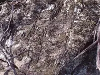
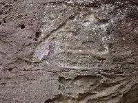
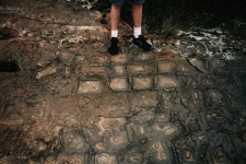
FELLAS, TELL ME WHAT YOU THINK ABOUT THESE TWO ROCK FACES.
BOTH ARE NEAR MY SITE AND BOTH PHOTOS COVER ABOUT 3'X4' AREA.

.................. NATURAL OR MAN MADE ................. :read2:

I DON'T REALLY HAVE STRONG SENSE ONE WAY OR THE OTHER.
THE ARROW, I MIGHT BE CONVENCED TO THINK, MAYBE MAN MADE,
BUT THE OTHER LOOKS LIKE A LOT OF WORK WITH NO REAL SOUL.

THINK ON 'EM AND LET ME KNOW :coffee2:
 

Attachments

  • kingmine1 030.1.JPG
    kingmine1 030.1.JPG
    120.3 KB · Views: 2,190
  • kingmine1 031.1.JPG
    kingmine1 031.1.JPG
    116.7 KB · Views: 2,185
Micheal,
I believe that the two photos are natural, for sure the first one, and the second IF it was used it would be a rock 'incorporated sign ' meaning it made by nature but they might have used it as a directional...however no other classic signs are found in the area, so it carries little weight so far...
the Sigma sign, has a value of 200 [greek alphabet] and the Z has been used for the pozo symbol in my experience...perhaps you are meant to go 200[measurements] to find the pozo?
the only way this would make sense is if you followed the strike[direction] of the vein [tunnel]
at that depth of the mine, an air shaft would be needed...just a wild ass guess as this is not the marks that are classically found at a site...
things to consider...
1.look for tailing piles...see what type of rock is there
2.photo the mine entrance up close, look for signs
3.step off 200 varas [for instance] see if you find a large boulder [covering the pozo]
4.get a 'geologic map' and see what type of rocks and intrusions are underground
5.look for the closest silver or gold mine in your area. faults travel miles underground
6.look for any markings on old beach or oak trees
7.research when the spanish where in that area
8.think about kgc possibility
9.talk to the historical society members or old timers in the area..they didnt miss too much
10. pay attention to any large boulders or rocks that have signs on them perhaps a map


I would back track some and see if you can find an alpha and or omega monument that would support that fact that this might have been spanish. hint, I would look first north of the mine..[where some high ground might be..]. it might help if you chalk the marks so they stand out a little in the photos...
hope this helps
rangler
 

Attachments

  • pirate with pistol skull.jpg
    pirate with pistol skull.jpg
    7.7 KB · Views: 1,923
Hi Prospectormike,

I believe the first photo is iron-rich Liesegang bands.
Supposedly they indicate that the sandstone has been saturated,
perhaps from within, and the water source (spring, etc.) has carrried leeched
particulate iron from a distant iron-bearing mineral finally depositing it in various patterns
within sandstone.....or something like that.
 

CLEVELANDB,
THANKS FOR THE INFO. I HAD NOT HEARD THE TERM "LIESEGANG" UNTIL NOW.
I DID A GOOGLE SEARCH AND FOUND SEVERAL GOOD LINKS, AND I AM SURE THAT YOU HIT THE NAIL ON THE HEAD.
TWO THINGS THAT STRUCK ME ABOUT THE SHORT RESEARCH THAT I DID WERE, FIRST I DID NOTICE THE USE OF SILVER (IN ONE FORM OR ANOTHER ) USED IN SOME OF THE EXPERIMENTS.
AND SECOND THAT SOME OF THE EXPERIMENTS APPEARED TO SHOW MAGNETIC PROPERTIES.

I WISH THAT I HAD CHECKED THE SECOND THEORY WITH A COMPASS WHILE I WAS AT THAT SITE.

I DO THINK THAT THE EXAMPLES SHOWN IN YOUR PHOTOS LOOK, TO THE UNRESTRAINED IMAGINATION, TO BE MORE APT TO BE MAN MADE THAN WAS MINE.... TOP ONE LOOKS LIKE
E.T. AND THE OTHER APPEARS MORE APT TO BE SIGN LANGUAGE.

THOSE ARE NOT THEORIES!! JUST THE WORK ON AND UNRESTRAINED IMAGINATION.

AGAIN THANKS FOR THE INFO.. THAT ROCK HAD ME PUZZLED FOR A WHILE.

:read2: :coffee2: :coffee2:
MIKEL
 

Hey, Mike and C.B.:
I wonder if that last photo has symbols made by scooping out sandstone layers and leaving iron reenforced layers to form those triangular shapes. :dontknow: After all, we've been told over and over that Spanish signs and symbols were made using natural shapes as their basis structure. Just a thought. And remember; the Spanish were late comers on this continent. Wouldn't the Ancients use similar ideas.........at least SOME times? :icon_scratch:
 

HEY SHORTSTACK,

ONE THING ABOUT THIS KIND OF RESEARCH IS THAT THERE IS ALWAYS ROOM FOR HOPE ON ONE SIDE AND DOUBT ON THE OTHER SIDE.

THEY ARE FACINATING SHAPES WITH MULTIPLE POSSIBILITIES. THESE ROCKS ARE ABOUT 2 MILES AWAY FROM MY SITE AND IN THE GENERAL DIRECTION OF MY RESEARCH, BUT I HAVE NOT YET PUT THE TO ANY REAL TESTS.

MY ORIGINAL THOUGHT, ON BOTH ROCKS, WAS NATURAL, EVEN THOUGH THEY WERE OUTSTANDING SIGHTS TO LOOK AT.

HAPPY HUNTING, BUDDY!
:coffee2: :coffee2:
MIKEL
 

You are exactly right in questioning everything about signs. In the case of these new designs, just keep an eye out for similar shapes, DRAWN on rocks or carved on trees, etc. That would be a "back up" for these shapes. Or better yet; perhaps these natural shapes were used as a source of IDEAS for coded shapes drawn on boulders or carved on trees.

These natural forms could easily be pure, naturally beautiful specimens of interests with nothing to do with treasure. Just keep them in mind in case you find something similar that is obviously manmade. Then, you can stop and reassess the situation.
 

MIKEL,
YOUR WALL LOOKS SOMETHING LIKE THE " CARPET ROCKS" THAT CAN BE FOUND AT PETIT JEAN STATE PARKS.

-WEEKENDER
 

Attachments

  • boulder3.gif
    boulder3.gif
    279.5 KB · Views: 2,151
WEEKENDER,

IT LOOKS LIKE THAT ROCK HAS HAD SOME TRAFFIC, OVER THE YEARS.
WHEREAS MINE IS IN A PLACE THAT WAS KNOWN AS THE "DEVIL'S PLAYGROUND" ABOUT 90 YEARS AGO. I KNOW AN OLD MAN THAT IS IN A NURSING HOME NOW, THAT WENT OUT TO THIS SITE WITH MY PARTNER AND ME. HE LIVED IN THE VALLEY BELOW THE SITE, AND WALKED TO SCHOOL AND BACK, THRU THAT AREA, AS A CHILD. HE IS IN HIS NINETIES NOW, AND IS NO LONGER ABLE TO TALK, DUE TO A STROKE.

HE TOLD US THAT WHEN HE WAS A KID, HIS DAD SEARCHED FOR THE MINE FOR YEARS WITHOUT FINDING IT. HE ALSO TOLD US THAT HIS DAD DID SOME BLASTING IN PART OF ONE OF THE BLUFFS AND CAME UP WITH SOME ORE THAT HAD "A FAIR AMOUNT OF SILVER" IN IT.

JUST ANOTHER STRAND OF HOPE.
:coffee2: :coffee2:
MIKEL
 

Thom,
you are correct, about the C on its back, however I do know that some signs
have their basis in the alchemy symbols of old...and as I persisted, I had to go
back to these days to actually find the ancient basis for the current C,
as it morphed from the cup..there is the actual cup...
hope it helps
rangler
amcl_bc03.jpg
 

RANGLER AND OLD DOG,

I TO, HAVE BEEN UNABLE TO TRACK DOWN ANY THING IN WRITING ABOUT THE CUP (CHALLIS) LIKE THE ONE THAT APPEARS ON THE BLUFF NEAR THE MINE OPENING, WHICH IS SEALED AND WELL CONCELED. THE STORY ABOUT THE BROKEN CUP CAME FROM A MAN THAT IS NOT ON
TNET. I WANTED HIM TO JOIN BUT HE DID NOT WANT TO. IF HE WERE HERE IN THESE DISCUSSIONS HE MIGHT GIVE UP THE SOURCE OF HIS THEORY.
HIS POINT WAS, THAT THE SIGN THAT LOOKS LIKE IT COULD BE A NUMBER 3 OR 5, TO ME, WAS IN FACT A CUP WHICH HAD BEEN BROKEN, MEANING THAT THE COVENANT WITH THE CHURCH HAD BEEN BROKEN. I HAVE NO PROOF YET.

THESE CUP S/S THAT YOU SHOW AND DESCRIBE, I BELIEVE ARE CORRECT AS YOU HAVE GIVEN GOOD DOCUMENTATION. I DO NOT KNOW HOW TO LINK THEM TO THE SIGN ON THE WALL.
THE ADDITION OF THE STEM TO THE BOTTOM OF THE CUP WOULD COME INTO THE PICTURE ALONG WITH THE ADDITION OF THE SPANISH (CATHOLIC) CHURCH AS THEY DO USE, IN SOME PLACES, A CUP WITH A STEM AND NOT WHAT WE WOULD CONSIDER A BOWL.

I DO NOT KNOW THE TIME FRAME FOR THE ADDITION OF THE STEM OTHER THAN ITS APPEARANCE IN ART WORKS. I AM NOT TRAINED IN THAT AREA, SO I FAIL TO DOCUMENT THAT INFO.

AS TO THE WHERE ABOUTS OF WATER, THERE ARE MANY SPRINGS IN THE AREA, AND LOCAL FOLK LORE TELL OF A PIECE OF SPANISH ARMOR BEING FOUND IN A SPRING CLOSE TO THIS AREA. THERE ARE TALES THAT REPORT A MASSIVE CAVE WITH A LAKE THAT MUST BE CROSSED IN ORDER TO GET TO STORED SILVER BARS AND MUCH VISIBLE ORE.

THE ORIGINAL CONTACT THAT I HAD WITH THE LAND OWNER WHEN WE STARTED WITH THIS HUNT GAVE SOME HOPE THAT WE MIGHT FIND SOMETHING OF THIS MANNER. HE TOLD JIM AND ME THAT HE HAD A WELL DRILLED NEAR HIS HOUSE AND AFTER DRILLING A CERTAIN DISTANCE, THE DRILL DROPPED INTO AN OPENING, AND THEY FOUND FRESH WATER SOME TWENTY TO THIRTY FEET BELOW THAT POINT.

SO IT MIGHT BE A SIGN OF WATER, BUT IF IT IS WHY WOULD THE CUP BE BROKEN?

RANGLER, I AM STILL WORKING WITH MY MAPS AND TOPO TO CHECK DISTANCES. I CAN NO LONGER GET TO THE SITE, SO I RELY ON TOPO TO STEP OFF 200 Xs FEET,VARA, AND SEEK IMPORTANT LANDMARKS TO DIVIDE THE DISTANCE BY 200. I HAVE FOUND A FEW CONNECTIONS THAT MUSHROOM INTO MORE POSSIBILITIES. I WILL POST THE RESULTS AS SOON AS I CAN FIND SOMETHING SOLID. I AM ALSO CHECKING RELATIONSHIPS BETWEEN THE LIST THAT YOU POSTED AND LANDMARKS ON THE SITE.

I DO APPRECIATE EVERYONE'S INTEREST AND POSTINGS.
THANKS
:coffee2: :coffee2: :coffee2:
MIKEL
 

WEEKENDER,
:hello2: :hello2: :hello2: :hello2: :hello2:TOP NOTCH RESEARCH :headbang: :headbang: :headbang:

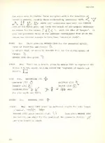
THAT IS THE BEST DOCUMENTATION FOR THE "Z" THAT I HAVE SEEN YET!!!

THE Z UNDER THE HEADING OF ZINC / DIDEROT-1763 IS ALMOST A PERFECT COPY!
THE ONLY DIFFERENCE IS WHERE THE CROSS-MARK IS LOCATED. THE SHAPE OF THE LETTER ITSELF IS NEAR PERFECT.

THE LETTER IS CROSSED ( ON THE BLUFF ) JUST AS THE "Z" ONE IN THE PREVIOUS HEADING
MARKED "ZELAB-1664". I TEND TO BELIEVE THAT IT RELATES TO ZINC BECAUSE THERE IS AN OPEN ZINC MINE WITHIN A QUARTER MILE OR SO.

THIS MAKES ME BELIEVE I CAN DATE THE CARVING OF THIS SIGN AT THE 1763 DATE.

THANK YOU.
:read2: :read2: :icon_sunny:
MIKEL
 

RANGLER,

THOSE LAST TWO IMAGES THAT YOU POSTED HERE ARE MINDBOGGLING. THE PAINTED IMAGE HAS ABOUT THREE DOZEN S/S IMBEDDED IN IT. SOME OF THEM MATCH UP WITH SOME OF THE S/S IN THE SECOND IMAGE.

I ENLARGED THE FIRST ONE X 400% AND FOUND A SIGN THAT CAME VERY CLOSE TO THE CUP SIGN, BUT IT IS TILTED ABOUT A QUARTER TURN CLOCKWISE.

IF I CAN EDIT THE MARK OUT OF THE IMAGE, I WILL POST IT. THAT'S A BIG IF FOR ME.
BUT THAT WILL NOT STOP ME FROM TRYING.

:coffee2: :coffee2:
MIKEL
 

Just a heads up on the tree, Indians use to do that as trail markers too..... 35 years ago when I first moved here there was one at the edge of a swamp that pointed to a safe passage through....
 

Top Member Reactions

Users who are viewing this thread

Back
Top