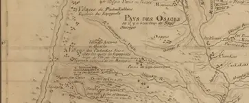
I posted a link to a map, earlier in the thread, that shows the region from Mississippi to Santa Fe.
Carte nouvelle de la partie de l'Ouest de la province de la Louisiane sur les observations et découvertes du Sieur Benard de la Harpe... / dressé par le Sr de Beauvilliers... | Gallica
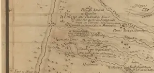
I believe it was made during the 1740s but I'm not sure. Looking at this section of the map, you can see Santa Fe and the village of the Padouka Noirs to the northwest.
View attachment 1402102
Here's a rough translation of the Padouka noir caption. "Villages of the black Padoukas which the Spaniards read from gold by caravans to the Tiguas around these mountains." During one of the early French explorations of this region, the French explorers were told that Spanish miners would come to this village to trade with the Padoukas. The Spanish came from the mountains to the west where they were mining gold with Indian slaves. I've read one account that said La Harpe had this information and another that said Bourgmont. Maybe both had it, maybe others. This map mentions La Harpe, but most of the information on the map came from other sources because La Harpe wasn't in most of these places. Here's something curious about the map. If you look at the position of Santa Fe, you will see that it's at latitude 36 deg and half of a degree, I'm not sure if that's .5 of a degree or 30' out of 60. Anyway, on google earth, Santa Fe is at 35 deg 41' so the map is a degree off. I guess the little circle with the cross on it, shows the location of the Padouka village at 38 deg 30', if half of a degree on the map is 30'. If that location is off a full degree, like the Santa Fe location, that would put the village at 37 deg 30'. The latitude of Treasure Mountain (Citadel Mountain) is 37 deg 27'.
 I had a few myth hunter shows to review. Thing is that Treasure Mountain show on myth hunters was like most all the other stories. Still the main source of this tail remains to be discovered I believe?


