Treasure Mountain, CO - Lost Frenchmens Gold

Hello Mdog

This might be of interest. In regards to Frank Velarde SR and Jr. In the United States census records. There was a grain farmer called frank Velarde born 1890 in Mexico but lived in Gardner Colarado as a farmer in 1910. Frank Velarde JR was born in 1927 as per 1930 census.

It appears the father crossed over the border into Mexico and returned via Texas in 1962 . It appears he died in 1967. If this is correct father and son combination with this name in Colorado. The alleged document if it was prepared for both father and Son was prepared or typed some time between 1962 and 1967.

Of course if this is the correct father and son combination? As there was a father and son in California. They had a grand father that was a Spanish general. but which ones are actually connected to the document I leave that to you.

Mal

Thanks Mal. I don't know how you got that information so fast. Gardner, Colorado is about 90 miles from Treasure Mountain and real close to treasure legend land. I guess somebody that close might have an interest in treasure legends. The Spanish general connection seems interesting too. The document was translated from French to Spanish. Thank you for the leads. I have an interest in Captain Louis de Villemont....maybe something there.
 

One more things before I disappear back to work, I fly back to my ship in Fiji in crew change over. See what mess my replacement captain has my ship in, picking up a load of sugar.

I do not know if it is of interest but its easy see how quickly the story can become altered over time?

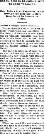
Daily Journal (Telluride), January 10, 1922.jpg

However the kudos to all its been a very interest thread so far....

Mal
 

Ya thanks you guys ,I sent us off on some Tangent here but good food for thought . SDC has told me before how hard it would be to do accurately without a real good time piece but some of these folks had real good calenders too . Who knows? not me
 

Last edited:
In 1756 could a navigator find longitude with accuracy?

My humble opinion No. Not to X marks the spot pinpoint accuracy.

In 1757, John Bird invented the first sextant.This replaced the Davis quadrant and the octant as the main instrument for navigation. The sextant was derived from the octant in order to provide for the lunar distance method. With the lunar distance method, mariners could determine their longitude accurately. Once chronometer production was established in the late 18th century, the use of the chronometer for accurate determination of longitude was a viable alternative.

In 1767 the first edition of the Nautical Almanac tabulated lunar distances, enabling navigators to find the current time from the angle between the sun and the moon. This angle is sometimes larger than 90°, and thus not possible to measure with an octant. For that reason, Admiral John Campbell, who conducted shipboard experiments with the lunar distance method, suggested a larger instrument and the sextant was developed.

Mal
 

Ya thanks you guys ,I sent us off on some Tangent here but good food for thought . SDC has told me before how hard it would be to do accurately without a real good time piece but some of these folks had real good calenders too . Who knows? not me

Not quite as it in some respects excellent relevant post.

One thing we need to do look at the context navigation coordinates are given?

For example one can assume that most fixed historic sites have cultural ties with heavens especially with the seasons connected to farming. Such places with such astrological alignments had a religious practical calendar base astronomical observations based from an already known fixed point ie the historical building or site. It was that particular cultures attempt to place themselves in the cosmos not a map to get to such historical site. because they were already there.


Most alleged treasure map co-ordinates work in reverse they are trying to pinpoint a given location based on calculations made from the various prime meridians mainly in a European concept of calculation on the size of the globe. The problem we have no European even after the invention of the sextant coordinate was 100% acute with actual true global position.

While I concede it much easy to find longitude on land that at sea, but add mountains and valleys and obscured horizon even land calculations can be way off... even by the best of them. At the end of the day navigational longitude and latitude is designed to get you in the general area. After that same is at sea visual landmarks that are prominent.

Even today with best of technology captains still will look for visual landmarks to confirm the position, what the GPS is telling us. While entering ports such as mountain peaks or light house or prominent landmarks.

Mal
 

Hi MDog,

I hope the info is useful. Basically, a Prime Meridian is a generally accepted starting point. Think of it like time zones around the planet. Take a look at a timezone map to see where midnight is. That will most likely be the prime meridian. Now, back in the day having different prime meridians would be like having different allocated 'midnight' timezone. If France had a declared prime meridian, it was as if that longitude was midnight on a clock. Traveling west five time zones should put you at 5:00 AM. If Mexico had their prime meridian and considered it their starting point of midnight on the longitudinal time zone clock, going five time zones over may be 5:00 AM for Mexico but something much later for France. Instead of time zone lines, they are longitude. This is why universal prime meridians were necessary. I remember seeing two different references to an Australian port that essentially had two different GPS locations due to differing prime meridians.

Gardner is about a 45 minute drive from my area. Its on the outside of the San Luis valley. Treasure Mountain is on the inside.

Mal, Great input. Thanks for sharing the knowledge and expertise.

Patrick
 

Magnetic variation is generally more worse toward north and south poles that affects compass bearing. There is another thing to consider all navigational sightings will never be 100% accurate. The earth is not exactly a sphere? It has a sight equatorial bulge that tappers to the poles. This when sighting a sextant like tool to a celestial body and the Horizon your calculation is always going to the out a little. As sea its even worse because everything is moving. With a sextant if you can get withing 60 km your doing well. Hell most officer on my ship has hardly if ever used a sextant these days. Computers and GPS can get you with in 3 m with a target. Any old chart will be actually out by several miles, unless the map has been made from a fixed bearings from a land mark.

Mal

Hi Mal,

With few exceptions, all of the topo maps I have used show the declination indicator somewhere. It looks somewhat like a large V with one side being vertical and the other showing the degree variance for declination.

The issue I have seen is when a treasure hunter is doing field research and they follow a map literally and the originators of the treasure used a compass.

Thanks for the great input.

P.

Magnetic declination constantly changes. In fact, the changes are currently rapidly accelerating. Most folks who drew accurate maps using accurate compasses were hopefully also smart enough to compensate for declination and used true north.

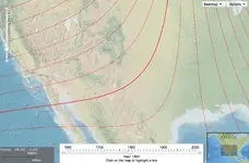
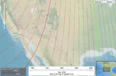
Here's some interesting data on declination: https://maps.ngdc.noaa.gov/viewers/historical_declination/

Look at the difference between the 1800 declination (top) and today's. The bold red line is the magnetic variance of 10 degrees east of true north.

1800.jpg

2016.jpg
 

Have any of you ever actually been on Treasure Mountain? Or even in Pagosa Springs? Just curious.
 

Have any of you ever actually been on Treasure Mountain? Or even in Pagosa Springs? Just curious.

I have never been there but the legend and the history are really interesting to me. I count on you guys who have been there to help us out when you can. :icon_thumleft:
 

I don't think you could use a meridian or a sextant to locate something there.
 

I don't think you could use a meridian or a sextant to locate something there.

I've done a lot of research about the Treasure Mountain legend, but I've never been there. If you disregard all the treasure legends about the place, is there anything about the mountain that would grab your attention, highest peak along a trade route, sacred mountain, unusual shape, anything like that?
 

Kanabite, South Sea Mariner, PatrickD, Sdcfia, thanks for the navigational information you all offered last night and today. That stuff has always been way over my head but you guys made it easy to understand. I even learned a few things I can pass on to my grandkids.
 

Top Member Reactions

Users who are viewing this thread

Latest Discussions

Back
Top