Treasure Marks/Signs - Diagnosed Here

symbols on boulders

Can you help us figure these carvings out? F6DF4BD35F1611DD.jpgF6DF4BD35F1611DD.jpgF6DF4BD35F1611DD.jpgEE6C4C245F1611DD.jpg
 

Sorry I duplicated 3 pics of of the same thing. Thought I had sent different pictures. Will try again. Thank you.. Hoping for some great input.
 

jwhedon, to me it looks like either 4 settlers leagues square, one settlers square ( best bet that its a 1 square league,) there may be 4 directions off of the head, the nose and reverse of the nose are 2 and the other two may be the other 2 directions are across the head, the height of the head will tell you the distance, looks like a cross on the boulder in the lower left hand side which would indicate a Church and it probably will be in the center of 4 settlers leagues, you could check it by looking either to the West, East, North, South for another Church for a distance of exactly 25 miles. This is when Google Earth comes in handy. Sometimes if you are lucky there will still be a Church around to measure from. In the vicinity of the head in the photo there should be seats, chairs, podium, There may be some drill holes near-by
 

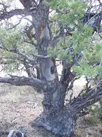
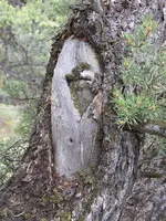
Ok....I am in dire need of help with these particular blazes. The one in the center is driving me crazy. Any ideas as to what they mean in context? It is like reading a book that is in a language that has never been written. I am perplexed......

mysteryblazes.JPG

Here is another at which I am sort of confused. It lies in an amazingly steep, treacherous canyon of solid granite. There is a small patch of trees in the canyon, and this blaze in a blaze is on the biggest tree. Could it mean there is a triangle up the canyon, and in one corner of it there is something covered? Once again, any help will be appreciated...

mysteryblaze317.JPG

Bytheway.....I don't want to get into a conversation on how old the blazes are,(I have 50 lbs. of research materials on that subject), just the meaning of the blazes...
 

Bonuntr, sometimes times trees are arranged in a triangle. Sometimes they can be newer, smaller trees than you would think... Also sometimes a limb can point to other markers or a boulder that is part of a triangle. They are likely blazed for one of those reasons.

Dsty, I know you are here to help, but when you are talking these markers meaning leagues away you are way off. I have seen many of these type markers together in single canyons, and you need to be talking feet and varas. Height of the marker is just to get your attention and usually means it's older and maybe even reshaped. Forget about the painted symbols, they aren't going to help in general but they can be on marker points to verify to use them and the bearings and distances will get you started. There is nothing in this that is always cut and dry, you may get lucky and find one where everything lines it out, but these guys made maps and there are people that come back to the sites and touch them up.


edit: also I will say Dsty you have some good stuff and I am not totally nagging on you, but the league stuff is not correct on any of these markers and it never has been , as well as the height of markers meaning far away. They are built to be seen from and bring you in from far away. They often look like nothing up close.
 

Last edited:
Very interesting photos bonuntr, thanks for posting them. I cant tell you what they mean, but it looks to me, they want you to go left? especially the top limb that looks to be graphed in there. And I think i may have see that lower symbol in yellow, in a hoyo shape before in stone, i thought of it as a ghost symbol.
View attachment 1210028
 

I hear folks talk about veras, I wanna see that tape measure? lol I bet you can eyeball most finds, there is a few measurements that are exact lol.
 

Hello Quinoa, I done my best to cover a 25 mile square ( what I call a township ) with permission to go anywhere with a pick-up to drive anywhere I wanted to , it was in north of Dallas Texas, land owner has Many sections, flat land, excellent ability to see very far. I was there on and off for 16 years, Lots of different measurements compass readings, when you get to the measurement of Leagues there 's 1/4 mile Knee high, they can be Vertical, or horzional in my world its 1220 feet. As with anything there are always variables even the mileage between towns. A handy GPS is helpful also. It is my belief that they had 28 inch vara up and including 33 inch vara and some that seemed to be a Royal Trail 66 inch X multiolier without any carvings between point to point. Thanks Quinoa, they were very sneaky at times. There's a land owner West Texas that I plan to contact near Amarillo.
 

Last edited:
Dog....
You said,"Very interesting photos bonuntr, thanks for posting them. I cant tell you what they mean, but it looks to me, they want you to go left? especially the top limb that looks to be graphed in there".

Wow...I didn't even see the graphing on the tree. Thanks for the heads up! It's funny, no matter how many times you look at something, sometimes you don't see what is right in front of you.
Please keep the ideas coming.
 

Thanks for the like Dog, I didn't get a reply on the Compass's that was posted I believe the degrees AND the distances do fit those that came before us used and it is my belief that different trail's was identified also by the different distances of the vara, such as 28 inch vara identified a trail as being hard, dangerous, slow, even the start may have been identified as such, The Settlers allotment seemed to be 33 inches and just normal trails. The Royal Trails that I have seen (3 ) seem to have a start that tells you all you need to know, Direction, distance I do not believe they left anything such as symbols / marker's between them as far as 2.5 miles, it seems they left a symbol the same as the first to identify it. If its that type the seem to have a cave or some type concealment such as a 18 inch wide X 16 inches deep X 44 inches long with perhaps gravel or a cap rock to use for cover and those may be as far as 1/2 mile off the trail for a look- out perhaps and I believe they used these to transport things of value. I believe they had different surveyors for each type trail and was well verses in them in other words they knew what they doing.
 

telephone pole

could be this a chicken ladder used to get in & out of mines number of rungs indicate depth in varras?
 

could this be chicken ladder that is used to get in & out of mines/ the number of steps or cross bar may indicate the depth
 

UPDATE from me: Don't get excited... not too much to tell.

So, went back with a buddy... what looks like an eagle head/beak in the one picture I posted looks NOTHING like that when you're up close... also, I'm 6'1" and I tried to find a place to look over the 'beak' where the 'gun sight' piece of the beak and the V'd tree make a heart... there's no way to do it... at least not unless you're over 7 or 8 feet maybe.

Also, looked into the crevice area... nothing was placed there and there's plenty of area to see down into what it is... it's just the space between two pieces of a boulder that cracked when it fell as far as I can tell...

I'm interested in...

A. trying to figure out the direction and distance I may have to travel from the carvings
B. what possibilities of what could be there
C. what are the dangers? what signs show danger/traps?
D. is this something I should rent or borrow a metal detector for?

...I'll post more questions as they come to me. We did find an old burned out mine entrance down quite a ways from where the markings are to the N/NE, but I didn't go up on the mountain side yet to check out the entrance...

~ Justin
 

I can tell you I have seen literally dozens upon dozens of these sort of alignments and monuments. They won't look perfect or man made when you get up close. If you can't look over it, then try standing where I said it should make a heart and look under it's beak thru the v of the trees. There will also often be an alignment directly where the eagle looks and directly behind where it looks. Pretty much four directions. Front, back, and perpendicular sides to it. These are placed specifically where they are to line up to multiple places and are said to Represent John, the 4th Gospel from the bible. The things that align will just be other types markers but they are what is important to figure the site out as well what Compass bearings they are on from it. Just look for anything out of place such as boulders or things that take shape or stick up or are off color to the surroundings. Pretty much most of the stuff you thought was natural before until you are able to take the time to look at it and put a compass to it.
 

Top Member Reactions

Users who are viewing this thread

Back
Top