Trail Signs and Monuments-Spanish or Somebody Else

Enough about mining to get myself in trouble maybe...

The "patio process" , using mercury began around 1554.
Prior , smelting was done heating ore to extract silver.High grade ore was the desired deal. And less high grade was still being mined then.
The lower grade ores remaining meant less efficient extraction. Plus "The New Laws Of The Indies" took native American Indians off the table as semi slave laborers...
Silver production was not doing good.
The patio process got it going again.

That does not end previous methods. Does not ensure previous methods continued , but smelters were the end of the trail for ore regardless of its form prior.


Most ore was likely taken to a smelter pre patio process. Find a furnace/smelter in the bush and bars could have resulted. At risk of being caught though ,and dependent on fuel and labor , food for that labor ,ect...

Lots of reading here...
DigiTool Stream Gateway Error

Thanks RC. This is the part of your post that caught my interest. I'm looking for smugglers.

"That does not end previous methods. Does not ensure previous methods continued , but smelters were the end of the trail for ore regardless of its form prior.


Most ore was likely taken to a smelter pre patio process. Find a furnace/smelter in the bush and bars could have resulted. At risk of being caught though ,and dependent on fuel and labor , food for that labor ,ect..."

RC, I tried to open the link you posted but had no luck.
 

There is a chapter in my book, about silver “dirty “bars.

About twenty miles south of my house, there was a pack train that was attacked in a creek crossing and a few mules were lost and silver lost.

Later on, down stream a few miles, a farmer was plowing a plot close to the creek. He hit several of these metallic bars and threw them into a pile.

Here is the link to this story...

This farmer was the father of a lady that my first partner knew when she was an elderly lady, and my partner was a young man.

He told me this story, that she had told him.

She had watched her father throwing the chunks of unknown material, and kicking the ground in frustration.

Here parents talked about it while eating supper, but she didn’t understand what it was about.

The next day a neighbor stopped by, on his way to town to see if they needed anything.

The man and her father talked then they went down to the creek and looked at the pile. They came up and took his wagon to the creek and loaded it up and they all went to town.

What she remembered most clearly was that she and the rest of the family got new shoes and brand new, Sunday clothes and Mom got a new cook stove.

My partner, Jim explained that the creek was in narrow banks where the old story about the silver was lost and that the farm was in the first open area for the water to loose speed and allow heavy objects to fall out of the flow during heavy flooding. So the bars were never going to be moved again by water.

The bars were not what we generally think of when we hear, silver bars.

They were made from low quality ore and poured into trenches carved into the ground, and when cooled they were pulled out and more were poured.

They were then shipped via pack mule , to another location to be purified and marked etc...

?? Were all of the parts of the story true and correct, that Jim told me???

I have never had a reason to doubt him, and I have been his friend for most of my life.

I believe that your earlier posts seem to follow the same process and patterns.

#/;0{>~

This is a real good story, Mikel. This excerpt is what is important to my study.

"The bars were not what we generally think of when we hear, silver bars.

They were made from low quality ore and poured into trenches carved into the ground, and when cooled they were pulled out and more were poured.

They were then shipped via pack mule , to another location to be purified and marked etc..."
 

They were headed south.
But where did they originate?

There is silver in Madison County according to court records of the trial of two counterfeiters that were caught because the coins that they were making were of better silver than the silver coins from the mints.
The records stated that they both said that the mine was was within a half day walk from the court house.

Nobody ever got them to give the location, and they didn’t come back to Madison County when they got out of prison.

“Good speed report for Madison County Arkansas “


#/;0{>~

Thanks Mikel. How can you tell that they were moving south.

You might be able to get some idea, about where they came from, by going to your county engineer and asking him for the original county survey notes. Sdcfia posted a link, in another thread that was really nice, but it didn't cover the whole United States.

https://glorecords.blm.gov/search/default.aspx

I used it to find the Indian and trading trails in my county. If you know the approximate location of where the silver bars were found, you might find a description of a trail in the survey notes.
 

Last edited:
Great story, dog, I think you've posted it before re origins of the Winnebagos being in the Southwest.

OK, the packtrain load was called "whitestone". This changes things a bit. As releventchair states in Post #142, silver was generally extracted from silver-bearing ore using the patio process, which required crushing the rock then spreading the fines in a big shallow rock basin mixed with water, mercury and salt to reduce the mess to more concentrated silver slimes. It took quite a while because the stew had to be stirred and mixed numerous times. Recovery percentage was fair to middling. Then the stuff was smelted. It was tedious. That's why I speculated that Spanish prospectors so far away from Mexico were much more likely to be seeking gold. It was easier and promised a better payoff if they were successful.

However, these miners in the story may well have found a deposit of native silver in their travels. From the historical account, it seems quite likely the miners were ambushed somewhere in southern CO, where native silver (pure metal) has a significant history all over the mining districts there. As you can see by the photo (from Creede CO), the stuff could well be called whitestone in its original form. If this was the case (speculation), the miners would not have needed to treat or smelt their find, since it was already pure out of the ground. Just pack up their lucky find and go home. As far as your cache is concerned, wherever the Winnebagos dumped it "in the woods", the stuff soon became tarnished black, wherever it was dumped.

View attachment 1675388

Thanks Sdc. Would the prospector have found silver that pure as an outcropping? And if so, would the silver that was exposed to the air be black? If it turns black, when exposed to air, would the fraud be exposed if the ore was used to salt a claim?
 

mdog,
Following old trails I read about or see on old maps has been one of my life's joys, also. Lumholtz's "Unknown Mexico" was my inspiration and guide to explore from Basasciache, Chihuahua to La Bufa, in the Barranca del Cobre, exiting the Barranca at San Rafael.
I once followed a road shown on a 1765 map that went through country that presently has no road. It was a 40mile walk. All I had was a hat and a pocket knife, but I found a spring or a tank every hour or so and some beautiful rockwork along steep, wall clinging inclines.
Keep on truckin! You never know what's around the next corner.
WH

Thanks White Heart. I looked up the Chihuahua trail you described. That looks like real rugged country. When you were walking the 1765 trail, did you find any petroglyphs, cairns or any other type of trail marker?

I wish I had learned about the old trails a long time ago. I find it real exciting searching for them and learning the history of those who used them.
 

Thanks Mikel. How can you tell that they were moving south.

You might be able to get some idea, about where they came from, by going to your county engineer and asking him for the original county survey notes. Sdcfia posted a link, in another thread that was really nice, but it didn't cover the whole United States.

https://glorecords.blm.gov/search/default.aspx

I used it to find the Indian and trading trails in my county. If you know the approximate location of where the silver bars were found, you might find a description of a trail in the survey notes.


My late partner Jim said that there was a king’s smelter on the Arkansas River.
They would have the clean up pure ingots ( the mine boss’s share)
If they had been coming from the south.

The knowledge that there is a record that states the counterfeiters said that there was enough silver in their mine to pave every road in the county !

The name of the area where they were making the coins is in the court documents; However, I stumbled into an old map that showed another place by the same name, that is much closer to me and Weekender’s site.

And that all may be enough to make us go back and look a bit more closely.

#/;0{>~
 

Thanks Sdc. Would the prospector have found silver that pure as an outcropping? And if so, would the silver that was exposed to the air be black? If it turns black, when exposed to air, would the fraud be exposed if the ore was used to salt a claim?

Yes, likely blackish on the surface. Toss an old silver quarter out in your backyard and come back to it in a few years. It'll likely darken up considerably. Copper pennies too, except they'll be a real dark greenish. Yeah, if fresh shiny silver was found on the surface, you'd smell a rat.
 

Thanks Mikel. How can you tell that they were moving south.

You might be able to get some idea, about where they came from, by going to your county engineer and asking him for the original county survey notes. Sdcfia posted a link, in another thread that was really nice, but it didn't cover the whole United States.

https://glorecords.blm.gov/search/default.aspx

I used it to find the Indian and trading trails in my county. If you know the approximate location of where the silver bars were found, you might find a description of a trail in the survey notes.


MDOG, I have been able to see some of the older maps, several years ago.

The, now semi retired, survey /engineer, is an old friend. He operated in a county office space that had been evacuated due to asbestos in the walls. He bought an old church building that was practically in his front yard and moved much of the older stuff into the building, after renovation to an office building.

I saw some of the older maps, before I knew what to look for.

They were stored in wooden shelves that had drawers that were made for large documents. Newest work naturally kept in the highest drawers.

You could pick a spot and go to the bottom and thumb through them and watch the population of an area with changes throughout history, in that area, with the utilities and changes in topography.

An amazing asset to folks like us.

Now the bad news....

A, never in recorded history of that area, flash flood that ran through the building and floated many pieces of light furniture out the back door.

Most were found, but the documents that were below the knees were damaged or destroyed.

He spent many months working to salvage the water soaked documents.

I believe, that was part of the choice to semi-retire. He wanted to spend more time recovering the historical documents. And less time in the field.

He showed me a line that he painted on the exterior of the building that was dated for the new record, high water mark. A farm house across the highway had been completely under water.

I will try to get over to see how much success he has had with the older maps.

I would love to see all of them saved and scanned into computers.

Lots to catch-up with.

#/80{>~
 

I spent some time looking at these and I think the best clue, for solving the mystery, is that petroglyph of the capital M and the eye right below it that Sdcfia posted on post #55.
View attachment 1676314

Here is just a little bit of the info i have found on the eye.
 

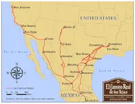
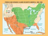
Here are a couple of maps to look at. One shows the land claims of France and Spain in colonial North America. The other shows the northern limits of the Royal Roads of the King of Spain.

FRENCH+AND+SPANISH+CLAIMS+ON+NORTH+AMERICA,+1682–1688 800.jpg Los_Caminos_Reales_DQ.jpg

So, the big silver mines, during this period, were in Mexico. Spanish Mexico was rich with silver but there was a shortage of currency in New France during the whole colonial period. The French King, Louis XIV, craved the silver mines of Mexico and was constantly probing the frontiers of New Spain, looking for any weakness that could be used to gain control of those Spanish mines.

Here's something else to remember when looking for colonial bullion trails, in North America, French merchants smuggled silver. Here's an excerpt about silver smuggling in Cadiz, Spain.

"The reason for the settlement of foreign merchants in Castile was the attractiveness of the American precious metals, although their exportation was forbidden26. French merchants were the most significant foreign merchants in Cadiz in the 18th century because the Spanish Succession war had given privileges to the French merchants and expelled English Protestant merchants27. French merchants were the main smugglers of silver."

"The smugglers were the most important wholesale merchant among all French merchants in Cadiz according to a contemporary ranking elaborated by J.-B. Partyet a Maurepas in 1736.29 Cadiz had in average 60 French merchant houses from 1724 to 1790 and the smugglers were the most important merchant houses among the French merchants who lived in Cadiz.30 The first class French merchant houses were in average the first quartile of the total number of French merchants in Cadiz and 100% of the smugglers were into this top class. This means that silver smuggling was totally a business of the first class French merchant houses."

"Thus smuggling was practised only by few and very powerful foreign merchants who were able to smuggle the silver because they had an international network to distribute the silver and granted diplomatic immunity to smuggle without risk of being captured. The French smugglers were organized in a cartel of a few powerful merchants linked in networks. Historical 18th-century trade networks combined formal limited-partnership ties with informal alliances based on family ties. Marriage, partnership and trade were closely related. Merchant and family networks linked individuals from similar geographic origins and professions, and were a common strategy used by Irish, Italian and French merchant houses, and also by merchants coming from the North of Spain and Catalonia. Alliances helped merchant houses to achieve stability and an adequate operation, and also contributed to the expansion of merchants’ networks towards the main centres of the European and Atlantic trade."

Here's the link.

http://economics.yale.edu/sites/def...nars/Economic-History/nogues-marco-110321.pdf

There were opportunities for the French to obtain gold and silver. They could find their own mines, in their own territory, or they could organize smuggling networks with miners already mining in land claimed by Spain.
 

Last edited:
My late partner Jim said that there was a king’s smelter on the Arkansas River.
They would have the clean up pure ingots ( the mine boss’s share)
If they had been coming from the south.

The knowledge that there is a record that states the counterfeiters said that there was enough silver in their mine to pave every road in the county !

The name of the area where they were making the coins is in the court documents; However, I stumbled into an old map that showed another place by the same name, that is much closer to me and Weekender’s site.

And that all may be enough to make us go back and look a bit more closely.

#/;0{>~

That reference to the King's smelter on the Arkansas River sounds interesting. Do you know much about that?

I don't blame you for checking out your site. That's a lot of silver.
 

View attachment 1676314

Here is just a little bit of the info i have found on the eye.

Thanks, Cyzak. Could you explain this a little more? The big eye labeled Super Glyph, it looks like the carving on the Mystery Glyph stones. Is this chart a collection of signs that could be the origin of the Super Glyph?
 

That reference to the King's smelter on the Arkansas River sounds interesting. Do you know much about that?

I don't blame you for checking out your site. That's a lot of silver.


MDOG, first of all welcome back!
And secondly, the story was Jim ‘s but I believe that it was true. He may have told me a few stories, two or three times, but they were the same each time. And up until the last six months of his life the only thing that would catch him off about was an occasional name. I was taking notes so that I could remember them, and I have those notes put up in a safe place, that I am sure I will find... someday.

When Orangeman and I have compared notes and photos of very similar markers that we have in common, we started looking for a common person or team.

De Soto was the first name that we found, but there were way too many different versions from his journal and his officers and soldiers, and even too many interpretations of the records to lock him in as the source to lock him in.
But we do know that he did manage to use and cross the Arkansas River in 1540 or 1541, just before his death in1541 at the mixing of the waters of the Arkansas River and the Mighty Mississippi River during a spring thawed following a record snowfall melt that widened the Mississippi so far that they thought it was the Gulf
(Of Mexico).

His most likely route was between our site and Orangeman’s! A seventy mile strip, as the crow flies.

So even if we failed to lock him at both places, the logistics would support that there was some common ground somewhere around the Arkansas River. The possibility still seem to point to that area.

There are two accounts for the counterfeiters. One was in the good speed report, and a later report of the same men, and a report that the Sheriff and a few others took photos of the silver coins , in peach baskets only a few inches deep, but with several layers of baskets stacked two and three layers deep on an old flat bed truck that stagers my imagination.


The name and proximity to the King mine of the place with the matching name, simply ties the knot a bit tighter.

Just building blocks of a half baked theory, yearning to be proven.

More to come...

#/;0{>~
 

View attachment 1676633Here is some more info on it i will respond shortly on this.

It's believed by many that an eye carving is telling you to look around, likely in the direction the carving is facing. Makes sense.

Your M-Eye is a Mystery Glyph. In my opinion only, based on my own experience only, you might think about getting GPS coordinates where this symbol is part of a panel of other Mystery Glyphs. Plot this location on a topo map. It very well may be one of three corners of a right triangle which has obvious clues located at the other two corners - natural landmarks, additional petroglyphs or something else very obvious. Of course, finding anothe of the corners is the challenge. Unfortunately, these corners may be miles apart. It's my opinion that these mystery glyphs were made to notice because they're so different, but they're not telling you a message - it's only their location that's important. Good luck.
 

MDOG, first of all welcome back!
And secondly, the story was Jim ‘s but I believe that it was true. He may have told me a few stories, two or three times, but they were the same each time. And up until the last six months of his life the only thing that would catch him off about was an occasional name. I was taking notes so that I could remember them, and I have those notes put up in a safe place, that I am sure I will find... someday.

When Orangeman and I have compared notes and photos of very similar markers that we have in common, we started looking for a common person or team.

De Soto was the first name that we found, but there were way too many different versions from his journal and his officers and soldiers, and even too many interpretations of the records to lock him in as the source to lock him in.
But we do know that he did manage to use and cross the Arkansas River in 1540 or 1541, just before his death in1541 at the mixing of the waters of the Arkansas River and the Mighty Mississippi River during a spring thawed following a record snowfall melt that widened the Mississippi so far that they thought it was the Gulf
(Of Mexico).

His most likely route was between our site and Orangeman’s! A seventy mile strip, as the crow flies.

So even if we failed to lock him at both places, the logistics would support that there was some common ground somewhere around the Arkansas River. The possibility still seem to point to that area.

There are two accounts for the counterfeiters. One was in the good speed report, and a later report of the same men, and a report that the Sheriff and a few others took photos of the silver coins , in peach baskets only a few inches deep, but with several layers of baskets stacked two and three layers deep on an old flat bed truck that stagers my imagination.


The name and proximity to the King mine of the place with the matching name, simply ties the knot a bit tighter.

Just building blocks of a half baked theory, yearning to be proven.

More to come...

#/;0{>~

Thanks Mikel. I haven't read anything about De Soto for awhile so I checked him out and was surprised how involved he was in the exploration and conquest in North and South America. Here's the link I read, for our Tnet members who don't know who he is.

https://en.wikipedia.org/wiki/Hernando_de_Soto

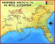
Here's a map, from the link, that shows his proposed route through the southeast United States. I didn't realize he was so far north. He was right there in northwest Arkansas.

DeSoto_Map_HRoe_2008.jpg

Mikel, there is something else that caught my attention, he was a member of the Order of Santiago. Here are a couple of symbols, related to that order, that you might want to watch for, if you're that close to his trail.

order of santiago 200.png

scallop shell 300.jpg
 

DeSoto_Map_HRoe_2008.jpg

He was right at a gold producing region when he passed through northwest Georgia and northeast Alabama. Mikel, did any accounts of the expedition mention anything about finding gold? You would also think that he would be marking his trail, in some way.
 

View attachment 1676768

He was right at a gold producing region when he passed through northwest Georgia and northeast Alabama. Mikel, did any accounts of the expedition mention anything about finding gold? You would also think that he would be marking his trail, in some way.

Yes MDOG. His mission was multiple goals. Crossing the Atlantic with as many as 500 ships. Several thousand men. His first task was to conquer Cuba, a fairly simple task, considering the size of his flotilla. Once done, he promptly appointed his wife Governor of Cuba in his absence. Next he left enough men and supplies to protect his Governorship and split the remaining ships and men, with half to travel south along the Central American coast to collect gold and anything of great value.

He and the rest of the men and ships were to set sail to conquer the Continent of (Florida)! Yes,,, Florida!
He was trying to get farther than his mentor and friend De Vaca, a Hero’s Hero, in his mind.

I believe that he made it almost to Iowa, and crossed the Mississippi River and started moving South by Southwest.

His plan was, originally to make it to the ( Great Northern seas) to create a shortcut back to China! A feat that DeVaca failed to complete, for rather obvious reasons.

As they crossed the White River in Missouri, just west of modern day Branson MO.

His log entry stated that he had much trouble finding a translator for the tribes to the south, as the tribe to the south were feared by almost every other tribe.

Nonetheless they crossed over the line and were attacked by a small group that were so fierce that they drove De Soto’s, 300 to 500 men back across the white river and they didn’t stop until all of his troops were so tired from running, that they fell asleep in the road.

After some rest and a new battle strategy they worked to separate them into smaller groups and even then De Soto wrote in his journal, that they were the most fierce opponents that he had ever encountered before!

The trail that they had blazed ran very close to Weekender and my site and Orangeman’ site.

We figured that they had blazed a trail to the Arkansas River and started moving eastward down the river where he met his end in the (Dismal Swamp)

His men split up and roughly 200 men tried to navigate the Mississippi River, but were afraid of dropping off of high waterfalls in unknown waters, in search for the Gulf of Mexico.

The other 200, or so, men started out westward in search of New Spain.

The sites and timeline are very hard to meld, but the basic framework is there. Very little was written about gold or the seven cities of Cebola, in spite of everything else that they had done, was to that end.

Well, that’s my take on the information that I could nail down.
There are several different accounts and other journals, that we took into consideration in order to come to these conclusions.

There are other documents that I have learned of, but couldn’t put my hands on, nor my eyes.

But there is a monument near the Arkansas River that states that they had camped there. I’ll try to back track to find the photo of that monument and add it here.

#/;0{>~
 

Last edited:

Top Member Reactions

Users who are viewing this thread

Back
Top