Trail Signs and Monuments-Spanish or Somebody Else

http://www.mysteryglyphs.com/pages/Articles/20090724_0001A.pdf Here is some pretty good info on the Glyphs I found that should explain a lot about how they were engineered.

Thanks, cyzak. That's an interesting article trying to interpret the Ojibway/Sioux symbols, mixed with Egyptian and Chinese. The result of the work was that maybe the carvings in California had something to do with determining summer solstice. Too bad it wasn't the winter solstice, as that's the one that northern hemisphere people have always been interested in and had a need for.

I'm familiar with three Mystery Glyph locations, one in Silver City NM (its exact position and a great deal about what surrounds it) another in Lordsburg NM (only know its exact location but not much yet about its surroundings) and the other in Tempe AZ (only know its approximate location and some things about its surroundings). There are railroads and treasure legends at all three of these sites.

First the Silver City NM glyphs. They are due west of a well-known landmark miles away and these two points form a perfect right triangle with an old deep cut six-foot cross. You could say the glyphs could be used to determine the equinoxes (since they form an east-west line), but IMO that's not their purpose. Their purpose was to set up a geometric pattern on the cardinal coordinates. Other clues forming right triangles were found within the big triangle using its sidelines, etc.

The Lordsburg NM glyphs I only found a year or so ago and haven't worked with them much yet. I'll have to go back down there and check again, but as I recall, neither the sun's sunrise equinox nor solstice locations can be seen from there. That's OK because an east-west line can be mapped from the carvings and then a guy can explore to the east to see what can be found. Then a right triangle can be mapped to the north and south. That's what I would do, but I don't know if I want to spend the time on it at my age, ha ha. Trouble is, I don't know the east-west separation distance needed to build the right triangle. I'll do some map work first and see if I can narrow down the target search area for more clues.

The Tempe AZ glyphs approximate location already helps form a pretty nice potential right triangle with two other things that people there might use in their Lost Dutchman and Peralta Stone Map legends. I'll never get too deep with it because I have no desire to spend time in the Superstitions.

The bottom line for me is that these Mystery Glyphs' locations were surveyed in (let's say late 19th century at the earliest) and used to map out other clues in the area based on right triangles and an east-west and north-south alignments. As always, I could be wrong about the glyphs in places I'm not well informed on, but I know I'm right with the Silver City NM carvings.

[Edit. I corrected the location of the glyphs discussed in the article.]
 

Last edited:
The glyph they talk about here was over by Panamint City Cali, and what is very interesting is how they were placed they did this so they could use the sun as a guide.These areas were not easy to access and some make them wonder how they were even able to carve were the location is at.
 

Last edited:
http://www.mysteryglyphs.com/pages/Articles/20090724_0001A.pdf Here is some pretty good info on the Glyphs I found that should explain a lot about how they were engineered.

Thanks, Cyzak. I agree with Sdcfia. I believe the location of the glyphs are one corner of a triangle. The glyph is put there to give a message to somebody. You have to figure out what would bring a person to that site. Not just any person, who makes an accidental discovery, but somebody who has some type of information to guide him there. Then, you have to figure out what is on the glyph that will lead you to the other two corners of the triangle. I also agree with Sdcfia that you will be looking for a right triangle. When you find that right triangle, it's been my experience that there is some information at the 90 deg angle that has some importance. It might even be somebody's name. Somebody of importance. Also, there could be multiple triangles one inside the other, starting out big, maybe hundreds of miles. and ending up small, maybe 1000 feet. The smaller triangles will be located near the 90 deg. angle of the next one bigger than it. Rabbit hole stuff.
 

Yes MDOG. His mission was multiple goals. Crossing the Atlantic with as many as 500 ships. Several thousand men. His first task was to conquer Cuba, a fairly simple task, considering the size of his flotilla. Once done, he promptly appointed his wife Governor of Cuba in his absence. Next he left enough men and supplies to protect his Governorship and split the remaining ships and men, with half to travel south along the Central American coast to collect gold and anything of great value.

He and the rest of the men and ships were to set sail to conquer the Continent of (Florida)! Yes,,, Florida!
He was trying to get farther than his mentor and friend De Vaca, a Hero’s Hero, in his mind.

I believe that he made it almost to Iowa, and crossed the Mississippi River and started moving South by Southwest.

His plan was, originally to make it to the ( Great Northern seas) to create a shortcut back to China! A feat that DeVaca failed to complete, for rather obvious reasons.

As they crossed the White River in Missouri, just west of modern day Branson MO.

His log entry stated that he had much trouble finding a translator for the tribes to the south, as the tribe to the south were feared by almost every other tribe.

Nonetheless they crossed over the line and were attacked by a small group that were so fierce that they drove De Soto’s, 300 to 500 men back across the white river and they didn’t stop until all of his troops were so tired from running, that they fell asleep in the road.

After some rest and a new battle strategy they worked to separate them into smaller groups and even then De Soto wrote in his journal, that they were the most fierce opponents that he had ever encountered before!

The trail that they had blazed ran very close to Weekender and my site and Orangeman’ site.

We figured that they had blazed a trail to the Arkansas River and started moving eastward down the river where he met his end in the (Dismal Swamp)

His men split up and roughly 200 men tried to navigate the Mississippi River, but were afraid of dropping off of high waterfalls in unknown waters, in search for the Gulf of Mexico.

The other 200, or so, men started out westward in search of New Spain.

The sites and timeline are very hard to meld, but the basic framework is there. Very little was written about gold or the seven cities of Cebola, in spite of everything else that they had done, was to that end.

Well, that’s my take on the information that I could nail down.
There are several different accounts and other journals, that we took into consideration in order to come to these conclusions.

There are other documents that I have learned of, but couldn’t put my hands on, nor my eyes.

But there is a monument near the Arkansas River that states that they had camped there. I’ll try to back track to find the photo of that monument and add it here.

#/;0{>~

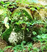
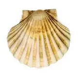
Thanks Mikel, good post. In post 178, I told you that you might want to watch for some symbol or monument that looks like a scallop, because a scallop is a symbol of the Order of Santiago and De Soto was a member of that order. Here is a picture of a rock formation at a Heart, Owl, Triangle site. Note the resemblance to the scallop.

HOT 600.jpg scallop 450.jpg
 

Thanks Mikel, good post. In post 178, I told you that you might want to watch for some symbol or monument that looks like a scallop, because a scallop is a symbol of the Order of Santiago and De Soto was a member of that order. Here is a picture of a rock formation at a Heart, Owl, Triangle site. Note the resemblance to the scallop.

View attachment 1677003 View attachment 1677004


I have not noticed any scallops, but I haven’t been looking for any.
Now that I know, I will be watching.

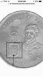
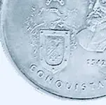
Speaking of signs... here is at least one of De Soto’s coat of arms, as seen on memorial coins after his death.

You might find one, that would give you a toe hold on whether he made it to your area.....

ImageUploadedByTreasureNet.com1549177461.096862.jpgImageUploadedByTreasureNet.com1549177519.660488.jpg

They are a bit vague and out of focus.

But one might turn up, and bing,you have your proof!!
 

Thanks White Heart. I looked up the Chihuahua trail you described. That looks like real rugged country. When you were walking the 1765 trail, did you find any petroglyphs, cairns or any other type of trail marker?

mdog,
Yes, rough country. The waterfall at Basechiache is 1000ft tall. The Barraca del Cobre is 6500 feet deep. My favorite memories come from meeting the people and the experiences in the villages so remote that in 1972 had only. footpath access to them.
If you have a chance to find the 2 vol. Lunholtz book, I know you will enjoy it.
I have remembered that when I found my 1953 german maps at a San Diego map store, the proprietor asked If I wanted a pair of 1919 maps of Sonora and Chihuahua that he had. They show all the villages and foot paths that connected them. Plus the very few roads. I will find them, now 100 years old, and post them. Just realized I have been housing them for 48 years....where does the time go.
Be well mdog.
I will tell more stories and post photos from old Mexico when I have more time.
WH

Thank you White Heart. Sounds like many fond memories. I was in places like what you describe when I was in Vietnam. I wish I had known the language when I was there. Those places are almost hypnotic. I look forward to your stories and pictures.
 

Here is an excerpt from a book titled Apogee of Empire: Spain and New Spain in the Age of Charles III, 1759-1789.

apogee of empire 700.png

This is the first time I've heard of this smuggling network. There is some discussion of it in the book but doesn't go into much detail. Here's the link.

https://books.google.com/books?id=3...named the ring new spain silver mines&f=false

If anybody runs across any information about this outfit, please post it. The book describes some of the European operations but I would like to find out if there were any smuggling operations in North America connected to this organization.
 

Last edited:
MDOG, here is a slightly different set of waypoints for De Soto.

I think that you might find enough close ties to this one, to start you looking...ImageUploadedByTreasureNet.com1549254994.440062.jpg

Smile [emoji4]!

#/;0{>~
 

Now... About that super glyph.

If these have only been found, where the gold and/or silver etc..., were possibly being in their final stages, of cleanup and accounting

Could these have been a vivid warning that the Royal Crown 🤴 was watching the operation, by placing, for less than the perfect words, private eyes [emoji102] , everywhere to insure safe and accurate accounting for every grain.

[emoji146]
👁

Or would my cheese just slide off the cracker as just a guess?

#/;0{>:~ (c)
 

FRENCH+AND+SPANISH+CLAIMS+ON+NORTH+AMERICA,+1682–1688 800.jpg Los_Caminos_Reales_DQ.jpg

We're going to look at options for a smuggling operation that begins in the Rocky Mountains.

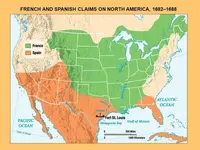
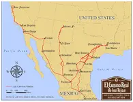
The map on the right shows the northernmost reaches of the Royal Roads of New Spain. The map on the left shows land claimed by Spain and France. Because the land was claimed, doesn't mean it was settled. There were very few Europeans north of Santa Fe and west of the Mississippi River, during the period between 1500 and 1800. During the late 1600's, the French were just starting to move west into the Mississippi River Valley, coming from Quebec. Meanwhile, the Spanish had a settlement at Santa Fe during the early 1600's.

When the Spanish invaded Mexico, they found that the Indians had a lot of silver and gold. This gave them the incentive to search for the places where the Indians found the silver and gold. Eventually, the Spanish located rich silver and gold deposits north of Mexico City. So, right off, the Spanish knew that there was silver and gold to be found, they just had to go out and look for it. This is what drove their explorations to the north into what became the American southwest.

Meanwhile, back along the St. Lawrence River, in New France, the French weren't having any luck at all finding gold or silver producing areas. They were making money in the fur trade but they knew of the Spanish mines in Mexico and they wanted their own gold and silver mines. Their western explorations were driven by the search for gold and silver and the Northwest Passage.

So, let's look at the circumstantial evidence for a smuggling operation from the northern Rockies to New France. Right off, I want everybody to know that I have never seen rock solid evidence of such an operation.

First of all the Spanish and the French would have to have something in common in order to have a profitable operation, something that would bind them together. That would be the Catholic religion, the French and Spanish were Catholics. Within the Catholic Church, there were religious orders that had missions in both New France and New Spain. One of these orders was the Jesuits, they had missions in New France as far west as the Mississippi River, and in New Spain in what is now Arizona. The religious certainly weren't above making a buck.

https://knowledge.e.southern.edu/cgi/viewcontent.cgi?article=1000&context=hist_studentresearch

So the goal of the smuggler is to avoid taxes get his gold and silver out of the mountains and find a place to cash in. He can't go south because he would be heading right into Mexico. His best option would be to go east toward the Mississippi River. At the Mississippi, he can trade his crude and unstamped bars, for Spanish silver or gold coinage. Then he can turn around and go back to Santa Fe with legal coins in his pockets.
 

Last edited:
MDOG, here is a slightly different set of waypoints for De Soto.

I think that you might find enough close ties to this one, to start you looking...View attachment 1677399

Smile [emoji4]!

#/;0{>~

This one makes sense to me because, the villages they were running into were the last of the Mississippian culture. Their religious center was at Cahokia, and even though Cahokia was not populated at the time De Soto was exploring, there would have been some major trails going in that direction.
 

Now... About that super glyph.

If these have only been found, where the gold and/or silver etc..., were possibly being in their final stages, of cleanup and accounting

Could these have been a vivid warning that the Royal Crown 老 was watching the operation, by placing, for less than the perfect words, private eyes [emoji102] , everywhere to insure safe and accurate accounting for every grain.

[emoji146]


Or would my cheese just slide off the cracker as just a guess?

#/;0{>:~ (c)

It's been awhile since I studied these, I think these panels have been found in populated areas close to towns that were established during the mid or late 1800's. There could be many more way out in the mountains, but, to me, the most important thing would be to find out why they were put where they are and where they are sending you. I'm guessing there are measurements on the rock that will give you distance and a direction to go.
 

View attachment 1677417 View attachment 1677419

We're going to look at options for a smuggling operation that begins in the Rocky Mountains.

The map on the right shows the northernmost reaches of the Royal Roads of New Spain. The map on the left shows land claimed by Spain and France. Because the land was claimed, doesn't mean it was settled. There were very few Europeans north of Santa Fe and west of the Mississippi River, during the period between 1500 and 1800. During the late 1600's, the French were just starting to move west into the Mississippi River Valley, coming from Quebec. Meanwhile, the Spanish had a settlement at Santa Fe during the early 1600's.

When the Spanish invaded Mexico, they found that the Indians had a lot of silver and gold. This gave them the incentive to search for the places where the Indians found the silver and gold. Eventually, the Spanish located rich silver and gold deposits north of Mexico City. So, right off, the Spanish knew that there was silver and gold to be found, they just had to go out and look for it. This is what drove their explorations to the north into what became the American southwest.

Meanwhile, back along the St. Lawrence River, in New France, the French weren't having any luck at all finding gold or silver producing areas. They were making money in the fur trade but they knew of the Spanish mines in Mexico and they wanted their own gold and silver mines. Their western explorations were driven by the search for gold and silver and the Northwest Passage.

So, let's look at the circumstantial evidence for a smuggling operation from the northern Rockies to New France. Right off, I want everybody to know that I have never seen rock solid evidence of such an operation.

First of all the Spanish and the French would have to have something in common in order to have a profitable operation, something that would bind them together. That would be the Catholic religion, the French and Spanish were Catholics. Within the Catholic Church, there were religious orders that had missions in both New France and New Spain. One of these orders was the Jesuits, they had missions in New France as far west as the Mississippi River, and in New Spain in what is now Arizona. The religious certainly weren't above making a buck.

https://knowledge.e.southern.edu/cgi/viewcontent.cgi?article=1000&context=hist_studentresearch

So the goal of the smuggler is to avoid taxes get his gold and silver out of the mountains and find a place to cash in. He can't go south because he would be heading right into Mexico. His best option would be to go east toward the Mississippi River. At the Mississippi, he can trade his crude and unstamped bars, for Spanish silver or gold coinage. Then he can turn around and go back to Santa Fe with legal coins in his pockets.

Good topic, dog. Human nature dictates that, if possible, smuggling would have been likely beyond the Northern Frontier of Mexico. Conditions needed to be met however in order for smuggling to prosper. First, there had to be commodities worth the risk. We know that precious metals were known by the Spanish to be present north of Santa Fe, all through southern CO and parts of central CO and UT. Maybe not the northern Rockies per se, but call it the central and southern Rockies anyway. For the most part, these areas were beyond much control of Spanish officials in Santa Fe. The further north, the less control.

There had to be capable miners who could recover the metal. This was not a serious problem, as mining technology was well known in the period you're interested in. Placer mining would be the easiest option, and likely lucrative as prospectors located virgin deposits that were easiest to recover. As recovery tapered off, the miners might quickly move on to find new deposits. Lode mining was more difficult logistically, as more resources were required for the mining and refining, and a more extensive permanent camp had to be constructed and supplied.

Security would have been a problem. The miners had to be able to enter and exit the mining area keeping a low profile, and once there, minimize detection from the natives, primarily. If they came from the east and returned that direction, say up the Arkansas River or other east-flowing streams, the risk was relatively low. If they came and went on the southerly route, the risk was much greater because they most likely traveled through or near Santa Fe and would likely have been noticed. The native problem may have been sporatic, as sometimes friendly relations existed, sometimes the times turned deadly. The history of the early trappers in the Rockies bears this out.

Bribery and secrecy usually accompanies smuggling. Of course, this raises the possibility that the Spanish officials in Santa Fe could have been involved. We know that a few Spanish mining forays were directed from Santa Fe into the southern Rockies, San Juans and parts of UT. It wouldn't be impossible for those Santa Fe bureaucrats to have hatched a scheme or two, although it would have been very risky for them and a death sentence if caught. If I had to choose, I'd pick the French as having the best chance of smuggling commodities out of the area in question, and to the east.

French. We know the French Jesuits were interested in the area and circumstantial evidence indicates at least one French-sanctioned mining venture may have occured in the region (the "Treasure Mountain" affair). The one point you've raised that would have been extremely problematical would be a working alliance between the Spanish and French Jesuits in the region. Keep in mind that NM was an exclusive Franciscan territory as ordered by the Pope - no Jesuits allowed. Moving goods from Sonora and Southern AZ easterly through NM seems very unlikely. I don't see how the two Jesuit outfits could have conspited with NM right in the middle of things. I support your French smuggling theory, but I'd think the French were on their own.
 

Thanks, Cyzak. I agree with Sdcfia. I believe the location of the glyphs are one corner of a triangle. The glyph is put there to give a message to somebody. You have to figure out what would bring a person to that site. Not just any person, who makes an accidental discovery, but somebody who has some type of information to guide him there. Then, you have to figure out what is on the glyph that will lead you to the other two corners of the triangle. I also agree with Sdcfia that you will be looking for a right triangle. When you find that right triangle, it's been my experience that there is some information at the 90 deg angle that has some importance. It might even be somebody's name. Somebody of importance. Also, there could be multiple triangles one inside the other, starting out big, maybe hundreds of miles. and ending up small, maybe 1000 feet. The smaller triangles will be located near the 90 deg. angle of the next one bigger than it. Rabbit hole stuff.

Sorry for introducing rabbit hole stuff on your post I will not do it again.
 

Here is an excerpt from a book titled Apogee of Empire: Spain and New Spain in the Age of Charles III, 1759-1789.

View attachment 1677384

This is the first time I've heard of this smuggling network. There is some discussion of it in the book but doesn't go into much detail. Here's the link.

https://books.google.com/books?id=3...named the ring new spain silver mines&f=false

If anybody runs across any information about this outfit, please post it. The book describes some of the European operations but I would like to find out if there were any smuggling operations in North America connected to this organization.

Gardoqui followed Lerena as finance minister. He set up in the U.S. and seemed to get along with folks well...

A mention unrelated to either (?) of smuggling.
[ Spain also provided financing for the final Siege of Yorktown in 1781 with a collection of gold and silver in Havana, smuggling from New Orleans began in]
https://wikivisually.com/wiki/Gardoqui
 

Last edited:
Gardoqui followed Lerena as finance minister. He set up in the U.S. and seemed to get along with folks well...

A mention unrelated to either (?) of smuggling.
[ Spain also provided financing for the final Siege of Yorktown in 1781 with a collection of gold and silver in Havana, smuggling from New Orleans began in]
https://wikivisually.com/wiki/Gardoqui

Thanks RC. Here's a link.

The American Revolution Story Has a Hole the Size of Spain : What It Means to Be American
 

Last edited:
Good topic, dog. Human nature dictates that, if possible, smuggling would have been likely beyond the Northern Frontier of Mexico. Conditions needed to be met however in order for smuggling to prosper. First, there had to be commodities worth the risk. We know that precious metals were known by the Spanish to be present north of Santa Fe, all through southern CO and parts of central CO and UT. Maybe not the northern Rockies per se, but call it the central and southern Rockies anyway. For the most part, these areas were beyond much control of Spanish officials in Santa Fe. The further north, the less control.

There had to be capable miners who could recover the metal. This was not a serious problem, as mining technology was well known in the period you're interested in. Placer mining would be the easiest option, and likely lucrative as prospectors located virgin deposits that were easiest to recover. As recovery tapered off, the miners might quickly move on to find new deposits. Lode mining was more difficult logistically, as more resources were required for the mining and refining, and a more extensive permanent camp had to be constructed and supplied.

Security would have been a problem. The miners had to be able to enter and exit the mining area keeping a low profile, and once there, minimize detection from the natives, primarily. If they came from the east and returned that direction, say up the Arkansas River or other east-flowing streams, the risk was relatively low. If they came and went on the southerly route, the risk was much greater because they most likely traveled through or near Santa Fe and would likely have been noticed. The native problem may have been sporatic, as sometimes friendly relations existed, sometimes the times turned deadly. The history of the early trappers in the Rockies bears this out.

Bribery and secrecy usually accompanies smuggling. Of course, this raises the possibility that the Spanish officials in Santa Fe could have been involved. We know that a few Spanish mining forays were directed from Santa Fe into the southern Rockies, San Juans and parts of UT. It wouldn't be impossible for those Santa Fe bureaucrats to have hatched a scheme or two, although it would have been very risky for them and a death sentence if caught. If I had to choose, I'd pick the French as having the best chance of smuggling commodities out of the area in question, and to the east.

French. We know the French Jesuits were interested in the area and circumstantial evidence indicates at least one French-sanctioned mining venture may have occured in the region (the "Treasure Mountain" affair). The one point you've raised that would have been extremely problematical would be a working alliance between the Spanish and French Jesuits in the region. Keep in mind that NM was an exclusive Franciscan territory as ordered by the Pope - no Jesuits allowed. Moving goods from Sonora and Southern AZ easterly through NM seems very unlikely. I don't see how the two Jesuit outfits could have conspited with NM right in the middle of things. I support your French smuggling theory, but I'd think the French were on their own.

Thanks Sdc. I don't think there would have been any alliance during the 17th century or the first 25 years of the 18th century, but after that, maybe, until 1762, when the French gave Louisiana to the Spanish.

There are hints of cooperation between the Jesuits of New Orleans and the Franciscans of New Mexico, concerning illegal trade, but I don't know if anything came of it.

It would be useful to know if there were trails along the Colorado River up to northern Colorado. Maybe one of our Tnet members has information about such a trail that can be posted. That would be a good way to avoid New Mexico and move east.
 

Top Member Reactions

Users who are viewing this thread

Back
Top