Trail Signs and Monuments-Spanish or Somebody Else

Some curiosity is all Mdog. I've little else to offer this morning.
Some distribution mentioned in this article. Few answers. A question though might be , did the Hopewell culture come up with the figures they did on their own? Or were they influenced by another/other culture.
They seem to have been exposed to others through trade/distribution.
As they would any signs created by others .

I don't buy the shaman use of pipes to create a trance. Though I don't know what shamans did thousands of years ago...
Pipes more recently and by some were sanctified. As ceremonial items should be. Pipe bags were not uncommon. Maybe telling in their decoration of more than being just a pipe bag.

Etiquette (depending on nation/tribe) dictated how a pipe for ceremony (and folks just plain smoked too in less elaborate pipes) was filled . How it was lit. How it was held to pass. Direction it was passed. Where it's ashes went after , ect.. Importance was there. A process far from casual , so it can be expected that a pipes form was as well. Beyond just being neat to look at.

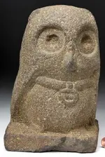
Why an Owl figure for a pipe?
Could it have been to represent a clan? Or simply an Owl? A particular spirit that the maker encountered? Or other inspiration?

Enigmatic 2,000 -Years-Old Carved Stone Owl Pipes ? An Ancient Unsolved Secret Of Illinois | Ancient Pages

Thanks for the link, RC.

So far, the oldest mound group found in the USA is at Watson Brake in north east Louisiana. The mounds there have been dated to about 3500 BC. So the Hopewell cultures, of 100 BC to 500 AD, would have had over 3000 years of influence from older Mound Builder cultures. As for the carved stone owls, the earliest examples that I've seen, are the small squat red stone owls of Poverty Point, 1700-1100 BC. Why the owl? I can only guess, like everybody else. The owl is kind of a mysterious animal and probably used by the spiritual leaders to scare the hell out of people. Kinda like how they used the snake. That might be why the owl is associated with shamen and witches. I've posted that the little owl beads, from Poverty Point, might have been some type of Old World influence left by traders who were mining copper in the Great Lakes region. As far as I know, Poverty Point was the first site that showed evidence of large ceremonial posts. Large wooden posts were used to represent ancient gods in the Middle East. Something else that might show an Old World influence are clay figurines of headless pregnant women. These figurines are also absent legs and arms.

https://www.crt.state.la.us/dataprojects/archaeology/povertypoint/ceremonial-life.html

Something else that shows on your link, the two mounds mentioned were real close to the Ohio River and there is evidence that Poverty Point collected grey northern flint very close to those two mounds.
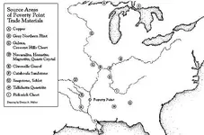
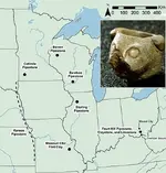
trade.jpg owlpipesillinois3map.jpg

I think the old shamen might have had some real good dope.

" Tobacco smoked by Native peoples had much more potent amounts of nicotine and could lead to hallucinations and altered states of consciousness, thus giving these individuals access to the “Above World.” However, due to geographical barriers and lack of access, modern American Indian descendants have never before weighed in on these speculative uses for the Adena Pipe."

http://www.ohiohistorycentral.org/w/Adena_Pipe

Here is a link showing part of Father Marquette's journal where he speaks of the sacred pipe.

SECTION 6TH
 

Last edited:
Nicotiana rustica has an arguable highest nicotine level. So much that it is a good choice for pesticide made from tobacco.
It is known to have been a native tobacco. I can't say it was the only type pre-Euro contact.

It's origin is (subject to scrutiny) South America. Aztec , with Mayan roots......:o
5-Artemis-Owl.jpg
 

Guess it was used more for getting dizzy than I gave it credit for.

There are claims it was native in the S.W. of North America in addition to South America.
It does not seem it would be grown in shorter season Northern regions with great success , but first the knowledge of how to grow , care for , and process would need to be learned . That and proper conditions. And water . And time to tend it in a non nomadic manner while still needing to produce foodstuffs if staying put to farm/raise crops that need tending.
Making it as good a trade item as long as it's being kept in demand....

[Used regularly in ritual and social contexts, tobacco and its counterparts were appreciated precisely for their physiological and mind-altering effects, which, among other things, aided the Amerindians in their pursuit of the supernatural. (Elizabeth Wyckoff)

It appears that tobacco’s mind-altering effects made it universally of interest to Native Americans in their religious observances and in preparing for war.

Among the Mayans, it was regularly offered to the gods both as incense burned on the altars and as smoke from the mouths of the worshippers. One of the best preserved reliefs from their ancient temple at Palenque shows a priest smoking a cigarette. Among the Aztecs, it was a necessary accompaniment to the ceremonies at which thousands of captives were slain in sacrifice to the god Tezcatlipoca. The medicine men of the more primitive Tonoupinambaultiis tribe in Brazil would fill and light their pipes and puff the smoke into the faces of the assembled laity, the purpose of this being to transmit the heroic virtues. "The warriors, thus prepared, attacked their enemies with demoniac fury and almost inevitably were victorious". (Sean Gabb, p.22)
As is clear from the quoted passage, the use of tobacco in religious and public ceremonies was nearly universal throughout the Americas among the various tribes of Native Americans. Its use as a medicine was also universal. The European explorers reported back that tobacco, in its various forms was used to cure almost every ailment known to man.]https://web.stanford.edu/class/e297c/trade_environment/health/htobacco.html
 

I’m gonna go get my little yellow, self inflating life preserver, put it over my head and pull the string, and ride the waves till my feet are on solid ground!
‘Cause you guys are playing in the deep end of the pool.

And my lil legs give out too fast.

#/;0{>~
 

I’m gonna go get my little yellow, self inflating life preserver, put it over my head and pull the string, and ride the waves till my feet are on solid ground!
‘Cause you guys are playing in the deep end of the pool.

And my lil legs give out too fast.

#/;0{>~

Hold on, Mikel. The KGC is coming up next week.
 

I think I hear the the clip clop of their horses now
They are a
hoof hearted bunch of guys.

#/;0{>~
 

I know that I have said that I don’t want to interrupt this conversation, but I have been reading that long winded law book on Spanish mining...

Early on They said that the clergy were not to be put to work in the mines.

It kinda left them to handle the paperwork...

But, down along article 30 through 32, or 33, They said that pretty much any land (not Royal land) was fair play, with some restrictions, including property of The Church!

Here is where I got a hitch in my get along.

If that “Anybody “ without restrictions, just happened to be a Priest, That “dug, or sank,”the required pit, and set the stake, and followed up with the technically, sub-steps that followed and hired “peones”(there word, not mine) to do the labor, there is a hole in the fence about priests not being able to own mines!

I know that I still have a lot to read and that the Spanish Crown, has a habit of just changing the laws, that from their point of view, ruled the world!

Nonetheless; there is a point in time, that it was possible for the church to own mines and handle the paperwork, that had made it possible to place their mark on the gold and silver bars...

Just some food for thought [emoji189]...

#/;0{>~

What page are you on, Mikel? I'll look closer tomorrow when I have more time.
 

A trail is the path you take to get from one place to another. As you travel along this path, you may pass landmarks and other terrain features that make each trail unique. If it's a good trail, you will want to remember it so you will mark it with trail markers or draw a map that will show you the way. Maps can also be used to pass on information by using place names and code. You just have to figure out what the important names are and what they are telling you. You also have to know that the shortest distance between two points, on a sphere, is a great circle segment. Google earth uses great circles to show the shortest path between two points. I'll show you how to use Google earth to find a code.

In 1975, a book was written by author Dell Schrader, titled Jesse James Was One Of His Names. Also known as the Black Book, this book has been the source of much debate on the Tnet forums. In this book the author gives a list of KGC treasure sites located in different cities around the United States. These cities are, Anadarko, OK., Columbus, OH., Cleveland, OH., Helper, Utah, Caldwell, Idaho, Brownsville, NEB., Davis, OK., Rush Springs, OK., Ada, OK., Salt Lake City, Utah, Cotopxi, CO., Mobile, OK., Durwood, OK., Ardmore, OK., Oklahoma City, OK., Paris, TX., Paul's Valley, OK., Orlando, OK. Plot all of these towns and cities, on Google earth. When you mark these places, make sure you put your markers right on top of the red dots that show where these towns are. Now start connecting the dots and look for organized patterns. I found a triangle that seems to have some well thought out organization. The triangle begins at Salt Lake City, where you click on the red dot and then run your line to Columbus, Ohio. If you continue that line, on to the Atlantic Ocean, you will find that the line goes through Washington D.C. This line passes 400 feet south of the Confederate Memorial at Arlington Cemetery. It also passes dead center through the Pentagon. Some vault searchers believe that the pentagon is an important symbol at vault sites. They might want to consider that those sites are KGC and not Spanish. It would be easy to create such a line using great circle segments. All you have to do is figure out where you want the line to end and where you want it to start. Then you pick a place name along that line to confirm the line. Say somebody in the KGC wanted to honor the Confederate war dead so they picked the Confederate Memorial at Arlington to end the line. So they picked Salt Lake City, as the beginning point and then figured out the great circle segment between those two points. After they find that segment, they find another town along that line to confirm it. You will notice, in the Black Book treasure sites, that Washington D.C. wasn't mentioned. Now, to complete the triangle and show further confirmation, you go to the southernmost town of Paris, Texas. Just northwest of Paris, you will see a cluster of towns in Oklahoma that shows you the way to go. Salt Lake City is on the east/west line, so if you want to make a triangle, you have to go to Salt Lake City. That will give you two legs of the triangle. The third leg is from Paris, Texas to the Confederate Memorial at Arlington. This gives you your triangle. Now to confirm you have the right triangle, you measure the distance from Paris, Texas to Salt Lake City and the Confederate Memorial at Arlington. From Paris to Salt Lake City is 1023 miles and from Paris to the Confederate Memorial is 1091 miles. This is a difference of 68 miles over a distance that covers thousands of miles. That's your confirmation.

There is something I forgot to add. On Google earth, the line from Salt Lake City to Arlington Cemetery shows a heading of 82.46 deg. A heading of 85 deg, is confirmation of a KGC/Organization site. That heading is used very often and it came from a tip in Sdcfia’s book New Mexico Confidential.
 

Last edited:
What page are you on, Mikel? I'll look closer tomorrow when I have more time.


Briefly put, page 8 , article 1 mentioned clergy working (anywhere in the Kingdom...

Then , in part 1,article 2, page 10.
As to where gold and silver ore can and should be looked for , by just about anybody.... it again mentioned land of the Church!

These and other times, at least into the pages in the 30s... get mentioned in one way or another.

In looking back, I realized that the laws get put into place and removed or altered every decade or so.

But it does seem to leave holes that greedy and crafty minds may have used the gaps in prohibitions to line their robe pockets, legally during the time of the gaps, and until the laws could be rewritten.

I believe that one needs to have a law degree to circumvent these wordy retractions.

I only brought up the possibility that there might be a few bars , legally, while other bars were hidden and not counted.... perhaps even lost in time for others to find....!?!

I’ll not chip away at the ongoing conversation again.

I know that it can be frustrating.

Sorry [emoji52].

#/;0{>~

I see what you are talking about. Seems like everything in the ground belonged to the King, but to encourage the discovery and working of mines, the King is letting anybody search for and claim mines even though it is on land that the King granted to noblemen or the clergy. This would allow the Indians and anybody else, to search and make claims. The Church might have made restrictions on what the clergy could do. The priests best bet would be to encourage the Indians to make claims and donate their share to the mission. I’m sure that if there was money to be made, the priests knew how to do it.

You post anytime you want, Mikel. Always glad to hear from you.
 

A trail is the path you take to get from one place to another. As you travel along this path, you may pass landmarks and other terrain features that make each trail unique. If it's a good trail, you will want to remember it so you will mark it with trail markers or draw a map that will show you the way. Maps can also be used to pass on information by using place names and code. You just have to figure out what the important names are and what they are telling you. You also have to know that the shortest distance between two points, on a sphere, is a great circle segment. Google earth uses great circles to show the shortest path between two points. I'll show you how to use Google earth to find a code.

In 1975, a book was written by author Dell Schrader, titled Jesse James Was One Of His Names. Also known as the Black Book, this book has been the source of much debate on the Tnet forums. In this book the author gives a list of KGC treasure sites located in different cities around the United States. These cities are, Anadarko, OK., Columbus, OH., Cleveland, OH., Helper, Utah, Caldwell, Idaho, Brownsville, NEB., Davis, OK., Rush Springs, OK., Ada, OK., Salt Lake City, Utah, Cotopxi, CO., Mobile, OK., Durwood, OK., Ardmore, OK., Oklahoma City, OK., Paris, TX., Paul's Valley, OK., Orlando, OK. Plot all of these towns and cities, on Google earth. When you mark these places, make sure you put your markers right on top of the red dots that show where these towns are. Now start connecting the dots and look for organized patterns. I found a triangle that seems to have some well thought out organization. The triangle begins at Salt Lake City, where you click on the red dot and then run your line to Columbus, Ohio. If you continue that line, on to the Atlantic Ocean, you will find that the line goes through Washington D.C. This line passes 400 feet south of the Confederate Memorial at Arlington Cemetery. It also passes dead center through the Pentagon. Some vault searchers believe that the pentagon is an important symbol at vault sites. They might want to consider that those sites are KGC and not Spanish. It would be easy to create such a line using great circle segments. All you have to do is figure out where you want the line to end and where you want it to start. Then you pick a place name along that line to confirm the line. Say somebody in the KGC wanted to honor the Confederate war dead so they picked the Confederate Memorial at Arlington to end the line. So they picked Salt Lake City, as the beginning point and then figured out the great circle segment between those two points. After they find that segment, they find another town along that line to confirm it. You will notice, in the Black Book treasure sites, that Washington D.C. wasn't mentioned. Now, to complete the triangle and show further confirmation, you go to the southernmost town of Paris, Texas. Just northwest of Paris, you will see a cluster of towns in Oklahoma that shows you the way to go. Salt Lake City is on the east/west line, so if you want to make a triangle, you have to go to Salt Lake City. That will give you two legs of the triangle. The third leg is from Paris, Texas to the Confederate Memorial at Arlington. This gives you your triangle. Now to confirm you have the right triangle, you measure the distance from Paris, Texas to Salt Lake City and the Confederate Memorial at Arlington. From Paris to Salt Lake City is 1023 miles and from Paris to the Confederate Memorial is 1091 miles. This is a difference of 68 miles over a distance that covers thousands of miles. That's your confirmation.

There is something I forgot to add. On Google earth, the line from Salt Lake City to Arlington Cemetery shows a heading of 82.46 deg. A heading of 85 deg, is confirmation of a KGC/Organization site. That heading is used very often and it came from a tip in Sdcfia’s book New Mexico Confidential.

This is an important post if you study the KGC. It shows that in 1975, a book was written about Jesse James and the KGC. In this book, the author revealed the locations of over a dozen KGC treasure sites. I don't know if treasure has been recovered at any of these sites, but the sites were used to create a great circle segment triangle with a Confederate memorial at the easternmost point. Think carefully about that. Treasure legends were created to locate points on a map.
 

This is an important post if you study the KGC. It shows that in 1975, a book was written about Jesse James and the KGC. In this book, the author revealed the locations of over a dozen KGC treasure sites. I don't know if treasure has been recovered at any of these sites, but the sites were used to create a great circle segment triangle with a Confederate memorial at the easternmost point. Think carefully about that. Treasure legends were created to locate points on a map.

While most treasure hunters are gawking at the magician's hands, mdog is interested in what's up his sleeves. Not a bad plan, IMO.
 

ImageUploadedByTreasureNet.com1551540706.728522.jpgImageUploadedByTreasureNet.com1551541079.372018.jpg

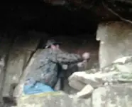
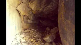
These are two photos of the easternmost point of Weekender’s and my site.
The empty cache vault that Weekender found on his first trip to the site.

It now has, his name in the book.

I now believe that it is the spot that was, the target of the triangle , that
confounded me for such a long time!

Empty or not, it was and is the eastern point on my map.

I have, since that moment, felt blessed that I photographed the moment of his discovery.

#/;0{>~
 

Last edited:
View attachment 1686198View attachment 1686199

These are two photos of the easternmost point of Weekender’s and my site.
The empty cache vault that Weekender found on his first trip to the site.

It now has, his name in the book.

I now believe that it is the spot that was, the target of the triangle , that
confounded me for such a long time!

Empty or not, it was and is the eastern point on my map.

I have, since that moment, felt blessed that I photographed the moment of his discovery.

#/;0{>~

Thanks for the pictures, Mikel. Do you have any idea what the headings are from the other two points on the triangle to the vault. Just curious if one of them might be 85 degrees, or close.
 

Here is a treasure legend that could be KGC related. It's a story about a place in Wisconsin named Wildcat Mountain. I chose this legend because it mentions the concealment of a large amount of gold and suggests that symbols were used at the cache site.

"During the term of Illinois Governor John Peter Altgeld, who held that post from 1892-1896, a load of gold in an iron-plated wagon was supposedly traveling from Billings Mont., possibly to Chicago. The reason? According to Boyer’s story, “Somehow there was a connection (between a Billings family) Governor Altgeld of Illinois, William Jennings Bryan, and some Oklahoma radicals…. Mention was also made of shadowy groups and odd conspiracies.”However, word got out that a load of gold was on the road, and soon everyone, from treasury agents to common highway thieves, was looking for it.
As the wagon train with the gold passed Wildcat Mountain, the man from Billings in charge of the expedition had the gold buried high in the rocks at night. Then the wagon train carried on. However, “Latin American revolutions and World War I claimed the lives of everyone who had seen where the gold was buried.”

"In letters to his family, the Billings man left clues about the treasure. “The letters contained obscure references to astronomy, astrology and mythology,” The story goes. These references intertwine with what has become a well documented history of spiritual happenings at the mountain.

The man Boyer interviewed added that there’s a ghost guarding the gold, but the ghost really doesn’t guard the treasure, instead its job is to lure people away.
“…This sentinel doesn’t stand on top of the gold,” the man said. “So, when people see this ghost they aren’t going to find anything. That’s the whole point, he decoys them away! The ghost throws people off the trail so to speak.”
The legend says that aside from the common odd noises and strange sights, the ghost likes to throw rocks and wields a Bowie knife. Some people have seen him on horseback, others have seen him standing on the rocks on the mountain with his rifle."

We're going to look at this story and search for evidence that it might be true.

"During the term of Illinois Governor John Peter Altgeld, who held that post from 1892-1896, a load of gold in an iron-plated wagon was supposedly traveling from Billings Mont., possibly to Chicago. The reason? According to Boyer’s story, “Somehow there was a connection (between a Billings family) Governor Altgeld of Illinois, William Jennings Bryan, and some Oklahoma radicals…. Mention was also made of shadowy groups and odd conspiracies.”

John Altgeld was governor of Illinois from 1893-1897. William Jennings Bryan was a Nebraska politician and was elected to the House of Representatives in 1890. Bryan was a free silver man who favored a monetary policy that featured the unlimited coinage of silver. Free silver policy was especially popular with the silver miners of the west.

So why would a wagon load of gold be headed for Chicago? It might have had something to do with the economic depression of 1893. The nations gold reserves had fallen below 100 million dollars setting off a financial panic when investors couldn't convert their assets to gold. Why did the Montana men from Billings decide to bury the gold on Wildcat Mountain. Was it for safety concerns, like the story suggests, or was it a financial decision to hide the treasure until the price for gold was more favorable.

"Mention was also made of shadowy groups and odd conspiracies."

This group could have been the KGC or some other secret organization.

Before I go on, I would like to describe the geographic features around Wildcat Mountain. Wildcat Mountain is just a couple miles south of Ontario, Wisconsin. A mile south of Wildcat Mountain is Mount Pisgah. At the foot of Mount Pisgah, is a creek called Billing's Creek. Probably just a coincidence, huh? Ok, here's our next quote.

"In letters to his family, the Billings man left clues about the treasure. “The letters contained obscure references to astronomy, astrology and mythology,”

This sounds like a well marked cache site to me. Something that is very complicated and organized. The following information could explain the reference to astronomy, astrology and mythology.

Mount Pisgah is where the Lord took Moses to show him the promised land of Judah. "So he took him to the field of Zophim on the top of Pisgah, and there he built seven altars and offered a bull and a ram on each altar." (Numbers 23:14, NIV 2011 [SUP][2]

[/SUP]The bull and the ram could indicate the constellations of Aries and Taurus. In Hellenistic astrology, the constellation Aries, the Ram, is associated with the Golden Ram and the Golden Fleece. The constellation Taurus, the Bull, is host to the star cluster the Pleiades, also known as the Seven Sisters. Some treasure searchers believe that the number seven indicates gold.

Finally, the last excerpt.

"“…This sentinel doesn’t stand on top of the gold,” the man said. “So, when people see this ghost they aren’t going to find anything. That’s the whole point, he decoys them away! The ghost throws people off the trail so to speak.”

The Field of Zophim, on top of Mount Pisgah, translates to mean, The Field of Watchers. This could explain the Sentinel part of the story.

It seems that the legend of Wildcat Mountain, has incorporated local place names in the treasure tale.


Last edited:
Here is a treasure legend that could be KGC related. It's a story about a place in Wisconsin named Wildcat Mountain. I chose this legend because it mentions the concealment of a large amount of gold and suggests that symbols were used at the cache site.

"During the term of Illinois Governor John Peter Altgeld, who held that post from 1892-1896, a load of gold in an iron-plated wagon was supposedly traveling from Billings Mont., possibly to Chicago. The reason? According to Boyer’s story, “Somehow there was a connection (between a Billings family) Governor Altgeld of Illinois, William Jennings Bryan, and some Oklahoma radicals…. Mention was also made of shadowy groups and odd conspiracies.”However, word got out that a load of gold was on the road, and soon everyone, from treasury agents to common highway thieves, was looking for it.
As the wagon train with the gold passed Wildcat Mountain, the man from Billings in charge of the expedition had the gold buried high in the rocks at night. Then the wagon train carried on. However, “Latin American revolutions and World War I claimed the lives of everyone who had seen where the gold was buried.”

"In letters to his family, the Billings man left clues about the treasure. “The letters contained obscure references to astronomy, astrology and mythology,” The story goes. These references intertwine with what has become a well documented history of spiritual happenings at the mountain.

The man Boyer interviewed added that there’s a ghost guarding the gold, but the ghost really doesn’t guard the treasure, instead its job is to lure people away.
“…This sentinel doesn’t stand on top of the gold,” the man said. “So, when people see this ghost they aren’t going to find anything. That’s the whole point, he decoys them away! The ghost throws people off the trail so to speak.”
The legend says that aside from the common odd noises and strange sights, the ghost likes to throw rocks and wields a Bowie knife. Some people have seen him on horseback, others have seen him standing on the rocks on the mountain with his rifle."

We're going to look at this story and search for evidence that it might be true.

"During the term of Illinois Governor John Peter Altgeld, who held that post from 1892-1896, a load of gold in an iron-plated wagon was supposedly traveling from Billings Mont., possibly to Chicago. The reason? According to Boyer’s story, “Somehow there was a connection (between a Billings family) Governor Altgeld of Illinois, William Jennings Bryan, and some Oklahoma radicals…. Mention was also made of shadowy groups and odd conspiracies.”

John Altgeld was governor of Illinois from 1893-1897. William Jennings Bryan was a Nebraska politician and was elected to the House of Representatives in 1890. Bryan was a free silver man who favored a monetary policy that featured the unlimited coinage of silver. Free silver policy was especially popular with the silver miners of the west.

So why would a wagon load of gold be headed for Chicago? It might have had something to do with the economic depression of 1893. The nations gold reserves had fallen below 100 million dollars setting off a financial panic when investors couldn't convert their assets to gold. Why did the Montana men from Billings decide to bury the gold on Wildcat Mountain. Was it for safety concerns, like the story suggests, or was it a financial decision to hide the treasure until the price for gold was more favorable.

"Mention was also made of shadowy groups and odd conspiracies."

This group could have been the KGC or some other secret organization.

Before I go on, I would like to describe the geographic features around Wildcat Mountain. Wildcat Mountain is just a couple miles south of Ontario, Wisconsin. A mile south of Wildcat Mountain is Mount Pisgah. At the foot of Mount Pisgah, is a creek called Billing's Creek. Probably just a coincidence, huh? Ok, here's our next quote.

"In letters to his family, the Billings man left clues about the treasure. “The letters contained obscure references to astronomy, astrology and mythology,”

This sounds like a well marked cache site to me. Something that is very complicated and organized. The following information could explain the reference to astronomy, astrology and mythology.

Mount Pisgah is where the Lord took Moses to show him the promised land of Judah. "So he took him to the field of Zophim on the top of Pisgah, and there he built seven altars and offered a bull and a ram on each altar." (Numbers 23:14, NIV 2011 [SUP][2]

[/SUP]The bull and the ram could indicate the constellations of Aries and Taurus. In Hellenistic astrology, the constellation Aries, the Ram, is associated with the Golden Ram and the Golden Fleece. The constellation Taurus, the Bull, is host to the star cluster the Pleiades, also known as the Seven Sisters. Some treasure searchers believe that the number seven indicates gold.

Finally, the last excerpt.

"“…This sentinel doesn’t stand on top of the gold,” the man said. “So, when people see this ghost they aren’t going to find anything. That’s the whole point, he decoys them away! The ghost throws people off the trail so to speak.”

The Field of Zophim, on top of Mount Pisgah, translates to mean, The Field of Watchers. This could explain the Sentinel part of the story.

It seems that the legend of Wildcat Mountain, has incorporated local place names in the treasure tale.

Great story, dog. "Wildcat" Mountain, eh? Sounds familiar to another treasure story in that general part of the US. I know how much you like place names. I wonder how that place got named and by whom.

Here's the best part of the story, IMO, and something readers might take to heart: “…This sentinel doesn’t stand on top of the gold,” the man said. “So, when people see this ghost they aren’t going to find anything. That’s the whole point, he decoys them away! The ghost throws people off the trail so to speak.”
 

Top Member Reactions

Users who are viewing this thread

Back
Top