Trail Signs and Monuments-Spanish or Somebody Else

Good link, dog. Those large carvings leave no doubt that they are indeed carvings, not merely "looks like" rocks. So many posted "looks like" rocks that folks ID as "manmade signs" pointing to some great hidden treasure nearby show no indications that man actually laid a hand on them. To be fair, some examples are intriguing, but 99% are products of hopeful and overactive imaginations. IMO.

Seems like those adept "ancients" who hid all this loot ought to have left a more definitive clue for their followers to find, not just a rock that, if you squint and hop on one foot sorta kinda looks like the King's poodle. Seriously, if these guys had the ability to circumnavigate the world, discover vast riches and then hide the goods somewhere in the wilderness (instead of taking it home with them), wouldn't you suppose their markers would be distinctive enough for anyone to recognize?

Here's a carving - not photorealistic by any means, but certainly recognizable to anyone - that was made 13,000 years ago in Gobekli Tepe. OK, let's say the cachers didn't carve a 3D figure, which is my belief. Why then not carve a glyph and/or some other symbol(s) - manmade and pertinent to later searchers? Carved bedrock is, except for a major earthquake or some other cataclysm, permanent. Not so for cairns, surface rocks, bent trees, carved cactii, et al, which can be knocked down, flooded out, moved, burnt or die of old age, all brought about by weather, animals, humans or time. Me, if I'm hiding stacks of gold, I'm marking it permanently with something clearly manmade.

View attachment 1680484

For Pete's sake, here's a carving in NM of two mountain lions made in Precolumbian times out of a soft, erodible volcanic tuff. Even with severe aging, this 700 year old thing - made with very crude tools - is certainly recognizable as being manmade. Let's face it - the ancients would have done better than the "looks like a horse" rocks and such that people want to believe was carved by them.

View attachment 1680485

Great post,Sdc. There are many treasure legends that mention just the things you talk about. A miner hides the gold or silver he has found and carefully marks the cache site. Ten years later, he goes back to the site and finds that there has been a fire or flood and the landscape has been changed to the point where he can't find any of his markers. It's how the lost treasure gets lost.

Where I live, there has been a lot of rain the past few years. Big boulders have been washed away and there have been landslides along the bluff. Trees have fallen and carved markers have been destroyed by vandals.
 

Thanks MDOG, I have seen several of the drawings. What I’m wondering about, is there are any photos of the Super Glyphs.

I’m a bit like you, wanting to see clearly made signs and symbols that are clearly man made.

By the way, I like the Superman. It’s clear that he has had a rough few centuries ( broken In three pieces) but leaves no doubt that he is hand made!

That is outstanding..
while I can understand the need to see clearly that it’s man made, I’m kinda relieved that some of them have just a little doubt, just to make folks have a hard time figuring out where my stuff is... so to speak. But I still want to know where it is!!

Always a great thread. Hitting the logistics is is a good idea.

I figured that out, when I started tracking down Hernand de Soto.

They had to abandon many of their horses because of the lack of iron to make horseshoes ... that had to be one of those teachable moments.

#/;0{>~

This link might be what you're looking for,

Mystery Glyphs - Images

At the top are states you can click on and it will show some glyphs that have been found in those states.
 

Thanks MDOG. That is what I was looking for.
I guess I missed the link on one of the posts.

Some of the links have so much info that I have got lost for hours.

I’m still reading the Royal decrees.

You have a hot topic... lots of good links here.

#/;0{>~
 

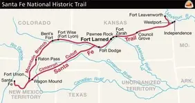
Here's a map of the Santa Fe Trail, a trade trail that linked New Mexico with western Missouri.

Santa-Fe-Trail-Route-Map_2.jpg

There was a lot of bullion that moved east, along this trail. Here are a couple links that describe the trade goods freighted on the Santa Fe Trail.

https://www.kshs.org/p/freighting-a-big-business-on-the-santa-fe-trail/12532

https://www.ci.independence.mo.us/userdocs/nftm/Barrels.pdf

This next link shows that Mexican traders went east to trade, taking bullion with them. The chapter titled Commerce, starts on page 190.

https://books.google.com/books?id=K...llion shipments on the santa fe trail&f=false
 

Some Tnet posters have said that the Mexicans used Heart, Owl, Triangle sites to cache bullion along the trails they use. If that's true, there should be cache sites, like those, along the Santa Fe Trail.
 

Some Tnet posters have said that the Mexicans used Heart, Owl, Triangle sites to cache bullion along the trails they use. If that's true, there should be cache sites, like those, along the Santa Fe Trail.

If that's true...... there could be cache sites just about anywhere that there was a trading post.
The farther away from civilization, the more likely.

One of the BANNER posts from Maryland, dug up a Spanish cob, among a bunch of other stuff from one hole.

#/;0{>~

:treasurechest:
 

If that's true...... there could be cache sites just about anywhere that there was a trading post.
The farther away from civilization, the more likely.

One of the BANNER posts from Maryland, dug up a Spanish cob, among a bunch of other stuff from one hole.

#/;0{>~

:treasurechest:

Exactly. Look for the trails that were used to move bullion from the gold and silver producing areas to places that had the products the settlements needed. The El Camino Reals in Mexico and the Santa Fe Trail are excellent examples. If the Spanish and Mexicans built the Heart, Owl, Triangle sites, those sites should be along those trails.
 

Here's a map of the Santa Fe Trail, a trade trail that linked New Mexico with western Missouri.

View attachment 1681928

There was a lot of bullion that moved east, along this trail. Here are a couple links that describe the trade goods freighted on the Santa Fe Trail.

https://www.kshs.org/p/freighting-a-big-business-on-the-santa-fe-trail/12532

https://www.ci.independence.mo.us/userdocs/nftm/Barrels.pdf

This next link shows that Mexican traders went east to trade, taking bullion with them. The chapter titled Commerce, starts on page 190.

https://books.google.com/books?id=K...llion shipments on the santa fe trail&f=false

The last link surprised me. I didn't realize that the Mexican traders were moving bullion further east from Independence, Missouri. That opens up a whole new subject for research.
 

Exactly. Look for the trails that were used to move bullion from the gold and silver producing areas to places that had the products the settlements needed. The El Camino Reals in Mexico and the Santa Fe Trail are excellent examples. If the Spanish and Mexicans built the Heart, Owl, Triangle sites, those sites should be along those trails.

This assumes that people who were in the possession of bullion were also not prepared to defend it. If so, why venture down the trail in the first place? Why not secure the bullion at the place of origin and not try to move it until it could be safely done?

If the bullion was being moved and the party was surprised/attacked, why assume they had time to locate a good cache site, bury the loot and mark it with a complex code?

The real question is, assuming a cache was made for whatever reason, what are the odds it was not later recovered?
 

Here is something interesting about a place along the Santa Fe Trail. There is a town named La Junta, Colorado, along the Arkansas River, that has Old World petroglyphs in the area. Here are a couple links.

Petroglyphs of Pergatoire River in Colorado

Make sure you click on NEXT at the bottom of the text, to make sure you read all the information.

https://michaelruark.blog/2011/08/0...s-been-found-intact-on-six-global-continents/

You'll also like this site dealing with the Heavener OK carvings, about 10 miles south of the Arkansas. "In Plain Sight" The Arkansas was like a superhighway from the Mississippi Basin to the West.

I'm generally a supporter of the Diffusionist arguments, but I also realize that ancient symbols can/have be reproduced in modern times. The problem is that there is not a definitive method of reliably determining the age of petroglyphs.
 

This assumes that people who were in the possession of bullion were also not prepared to defend it. If so, why venture down the trail in the first place? Why not secure the bullion at the place of origin and not try to move it until it could be safely done?

If the bullion was being moved and the party was surprised/attacked, why assume they had time to locate a good cache site, bury the loot and mark it with a complex code?

The real question is, assuming a cache was made for whatever reason, what are the odds it was not later recovered?

Excellent points that have been overlooked or ignored, in the past.

When the Spanish claimed New Mexico, trade was illegal with anybody but the merchants in Mexico, so any trading done, with anybody else, would be on a smaller scale and away from any Spanish settlements. Most of the freighting done, on the Santa Fe Trail, was done after Mexico won it's independence from Spain. It seems the biggest threat of attack, was from Indians. Because of this, the freighters traveled in large groups with many men to defend the trains and take care of the stock. Also, if the Heart, Owl, Triangle sites were required by the King of Spain, than there would not be any along the Santa Fe Trail. After Mexican Independence, why would the Mexican's use the Heart, Owl, Triangle method, if they were not required to do so. If there are any Heart, Owl, Triangle sites, along the Santa Fe Trail, they were probably put there by another group, not Spanish or Mexican.
 

IMG_5876.jpg
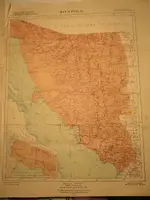
Sonora
mdog,
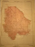
I could not scan the maps, but I hope these photos are good.
First edition 1919, last update 1942.
The faint yellow shows a driving trip we made circa 1970.
WH
 

Thank you for posting your maps, White Heart. Looks like you had some pretty desolate stretches on your journey. I see the town Arizona is marked west of Nogales. That would have been where the balls of silver were found. And the road going north to Nogales must be the old Royal Road. There's another Royal Road that goes north through Chihuahua to El Paso. Looks like you might have got close to the Royal Road by Alamos, on the Hermasillo-Durango stretch.

What is the most memorable experience you had on your 1970 trip?
 

You'll also like this site dealing with the Heavener OK carvings, about 10 miles south of the Arkansas. "In Plain Sight" The Arkansas was like a superhighway from the Mississippi Basin to the West.

I'm generally a supporter of the Diffusionist arguments, but I also realize that ancient symbols can/have be reproduced in modern times. The problem is that there is not a definitive method of reliably determining the age of petroglyphs.

That is a good link, Sdc. Thank you.

To my fellow Tnet readers. I wish I had looked for this ancient evidence when I was younger. I knew of it, but I never thought I would find anything like it, where I live. I was wrong. There are many ancient mysteries to be discovered and researched. Almost all of this thread has concentrated on trade trails, prehistoric and historic. Look for these trails, where you live and then look for evidence left behind by the people who used them. One way to find old trails is to go to your County Engineer and see if you can look at your county's original survey notes. Those notes might describe Indian trails and villages and early white settlements. Get to know your local librarian or historian, they can give you a lot of help.
 

You'll also like this site dealing with the Heavener OK carvings, about 10 miles south of the Arkansas. "In Plain Sight" The Arkansas was like a superhighway from the Mississippi Basin to the West.

I'm generally a supporter of the Diffusionist arguments, but I also realize that ancient symbols can/have be reproduced in modern times. The problem is that there is not a definitive method of reliably determining the age of petroglyphs.

You are so right about the Arkansas River. The mysteries of that river could be explored for a lifetime, especially if you are a treasure hunter. The same goes for the Rio Grande. They both source near gold and silver producing areas and provide a downstream route that ends up in the Gulf of Mexico.
 

That is a good link, Sdc. Thank you.

To my fellow Tnet readers. I wish I had looked for this ancient evidence when I was younger. I knew of it, but I never thought I would find anything like it, where I live. I was wrong. There are many ancient mysteries to be discovered and researched. Almost all of this thread has concentrated on trade trails, prehistoric and historic. Look for these trails, where you live and then look for evidence left behind by the people who used them. One way to find old trails is to go to your County Engineer and see if you can look at your county's original survey notes. Those notes might describe Indian trails and villages and early white settlements. Get to know your local librarian or historian, they can give you a lot of help.

Here's a great site for finding information. https://glorecords.blm.gov/search/default.aspx?searchTabIndex=0&searchByTypeIndex=1 I've found all kinds of interesting things in the Field Notes for the original government Township surveys. The plats themselves also show stuff you might not find elsewhere.

Hey, dog, weren't there some interesting carved stones with Egyptian symbols found in eastern Iowa near the river?

Yes, the Davenport Tablets were found in a couple of mounds, but were determined to be fakes. They were planted in the mound by jealous colleagues of the guy who was excavating the mounds.
 

I’d like to tell you that I have read everything that you guys have posted and that I agree with 99% of it.

But that would just be an out and out lie!

I had ya for a second or two!....
but the stuff that I liked, I did dig into (and understood some of it)

Truth is.... I’m stretching my self a tad bit thin.

But I did see one of those petroglyphs that had a bunch of older stuff that had a buffalo and her calf plastered over a bunch of stuff from an older civilization’s stuff.

I didn’t see it mentioned in the part that I read about tent points etc.

When I stopped to see where I was, I came out on the latest post at that time.
Did anyone else see that also??

If so tag it so I ain’t crazy [emoji12]
#/;0{>~
 

Top Member Reactions

Users who are viewing this thread

Back
Top