The Quest for Maine Gold

Remember to follow the gold to the source. In the streams. Look for the bigger chunker gold and follow it up stream. It may not be coming from the hill side. And i think I read platnum is connected to lead. With the lead mines in the area. And of course silver can come lead. Usually with a little gold mixed in. You are finding a fair amount of gold in a few test pans. Wish you had a sluice and run a few yards. Would love to know the results. Good work hang in there.

One reason I might be getting quite a bit of gold in few pans is where I chose to test-pan. I know this is kind of wrong, but my goal at this point is to see if a location has gold so I seek out areas of the stream where this is most likely. I only pan on top of bedrock, on the inside bends, and in areas of gravel that have high amounts of quartz float.

I mean like in my gravel pit, I deliberately panned gravel directly on top of bedrock as it was the highest likely location to find gold. Now that I have found it, now I must do further testing to see where it lies. Areas of my gravel pit are 32 feet deep to bedrock, so I already know I am going to have to move a lot of material to get the gold. But that is research for another day. Right now I am just trying to find where the gold is, and where it is not.

Two other factors also come into play. The first is that these streams, if they have ever been checked for gold at all, was likely over 100 years ago, so I have no competition. And the other factor is, I am finding seams of quartz all over the place, so the gold in these streams, has not moved far.
 

The funniest part was “drinking out of the golden goblet”. Here we can drink the water in streams because it is safe to do so, and I had just panned this stream, but since I use my pan as a cup, I was drinking away when I saw specks of gold that had stuck to the bottom of the pan. It was kind surreal to see gold glittering off the bottom of the cup as I was drinking.

Enjoying reading your journal, but the above comment concerns me.

What causes you to believe that the creek water is safe to drink? In one
of your pics, above, you show a beaver dam, meaning there are beaver
in the area. Doesn't take but a few "beaver biscuits" for that water
to be full of giardia, which will give you a galactic sized case of beaver
fever. Trust me, you don't want that in your body!

Just be careful where you dip your goblet..:occasion14:
 

Ore cart. The testing your doing is good. But always test back to the source if possible. You may have veins running under the streams. Or into it. And study the gold. Chunky gold or larger pieces means your getting closer to the source. And from your tests id says its very possible. There are some veins. But if it is virgin could be just a good amount of placier gold. Quartz means a lot. But also look for veins of pyrite, iron stone, arsenical pyrite,Tonalite, and schist. And other related minerals.
 

Enjoying reading your journal, but the above comment concerns me.

What causes you to believe that the creek water is safe to drink? In one
of your pics, above, you show a beaver dam, meaning there are beaver
in the area. Doesn't take but a few "beaver biscuits" for that water
to be full of giardia, which will give you a galactic sized case of beaver
fever. Trust me, you don't want that in your body!

Just be careful where you dip your goblet..:occasion14:

Oh yes, one always has toe be wary of where they dip their goblet, or at least my wife threatens me with that same line all the time!! (Only teasing you with my innuendo here, and mean no offense).

You are right of course, in that there is no way to tell if there is bacteria present in the water. I have never had any trouble in drinking stream water here in the 45 years I have been alive, but that does not mean sickness will not, or could not happen. I should get a Lifestraw, but I am already packing so much other crap.

One thing I did not mention was that I got seriously turned around on this last adventure (the five stream adventure). I have not been in that area much, and while not scared-stiff-lost, for about a half hour I wondered around a bit. Beyond packing a pistol, and a Lifestraw, I thought a few times of how nice it would be to have GPS too!! I do carry a compass though! I am not so stupid I will not do that.
 

Ore cart. The testing your doing is good. But always test back to the source if possible. You may have veins running under the streams. Or into it. And study the gold. Chunky gold or larger pieces means your getting closer to the source. And from your tests id says its very possible. There are some veins. But if it is virgin could be just a good amount of placier gold. Quartz means a lot. But also look for veins of pyrite, iron stone, arsenical pyrite,Tonalite, and schist. And other related minerals.

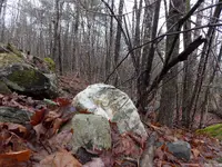
I do not really take written notes, but I am always checking any outcrops for mineralization. For instance in the last trek, I found an old rock wall in an old pasture, and took a picture of a piece of quartz with heavy mineralization. So I do keep my eyes open.

One thing I have never found is any appreciable size nugget. I find pickers, flakes and specks of gold, but so far no real nugget like others on here find. Maybe some day!

Here is that Quartz found on an old rock wall.

DSCN0562.JPG
 

Hard to tell by the picture. But the big Quartz rock. The veins in it look like lead.
 

Hard to tell by the picture. But the big Quartz rock. The veins in it look like lead.

I thought it might be silver, but you are probably right. There is a LOT of galena here, but surprisingly little silver despite silver being associated with galena as well.

The quartz here is very mineralized, and very fractured. I have not retrieved quartz very deep in the vein, so anything I have come across has been subjected to the freeze-thaw cycles of New England, but a big chunk of quartz one of the skidders kicked up last winter, split like granite with a single whack with chisel and hammer. Not just once, but the whole thing. It was just criss-crossed with fractures.

All the quartz here is broken up like that. And any quartz that has been exposed, like on the rock walls, or within plow-depth, is very vuggy, presumably from 219 years of exposure to oxygen.

I do have some areas that were Old Growth Forest, and have never been either pasture or tilled fields due to their distant location from our farm. I could tell this because as I logged it, the equipment would churn up the forest floor and turn red within a few weeks. That was the iron in the soil starting to rust away, something that would have been done years ago if it had been tilled, or even pasture, since the hooves of sheep would have churned up the soil.

I do not believe it was even logged. I know it was never logged in my Grandfather's lifetime, and the distance, and topography would have made it impossible to log by horse. It has been only by the advancements in forestry equipment that we have finally been able to get under active forest management, every acre here. (1746-2018...272 years).

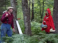
This picture shows when it was Old Growth Forest back when Katie and I did a photo shoot of her as Little Red Ridinghood, and me as the logger that saved her from the Big Bad Wolf. It was all in fun!

Logger and Little Red Ridinghood.JPG
 

Last edited:
By the way: check out the teeth on that old cross cut saw!

I am not sure how much you (or anyone else that is reading this) knows about old cross cut saws, but that is the old fashioned kind of teeth. Yes, this saw is designed to buck HARDWOOD, but that type of tooth, in conjunction with its riveted handles, and camber of the blade suggests it was made around 1830-1850.
 

That’s an interesting looking crosscut saw OreCart. Any markings on it? Could you take a closeup picture of the teeth pattern?

We have a great great history of logging here in Northern California. The old two man bucking saws were/are an awesome tool. It would be cool to see the one from your family homestead.

Thanks,
Mike
 

That’s an interesting looking crosscut saw OreCart. Any markings on it? Could you take a closeup picture of the teeth pattern?

We have a great great history of logging here in Northern California. The old two man bucking saws were/are an awesome tool. It would be cool to see the one from your family homestead.

Thanks, Mike


Yes and no! (LOL)

I do not have a close up of the teeth readily on my computer, but I still have the saw and so I can take a picture of it.

If you love cross cut saws like I do, there is a free downloadable book dedicated to them from the US Forest Service. A forest ranger in the 1970's realized people were losing their knowledge of them, and comprised a book for antiquity. You can order a paper copy, but a PDF version is free. It is only 20 pages or so, but has a TON of information on cross cut saws.

As for markings, there is nothing that I can see. This saw is all pitted up, and beat up!

One thing that is odd about it, is that the rakers have all been broke off...everyone. To me it seems like it was deliberate. This is not a ice saw (this is New England so everyone cut ice off the ponds in the winter), but maybe it was modified? If it was, it had to be used in crosscutting long blocks of ice because the second handle could not have been inserted in the saw cut otherwise. Even then it is just a guess, as I cannot imagine why a raker would impeded the cutting of ice?

Maybe a hay saw???

I will get you a picture though!
 

That’s an interesting looking crosscut saw OreCart. Any markings on it? Could you take a closeup picture of the teeth pattern?

We have a great great history of logging here in Northern California. The old two man bucking saws were/are an awesome tool. It would be cool to see the one from your family homestead.

Thanks,
Mike

Totally unrelated to saws, but I was super excited this weekend as I have been redoing my front yard, and built a set of granite steps out of some old granite slabs I had kicking around. Well I have been looking for this all my life, and it was the first time I have ever found it...hand split granite done by flat chisel!!

About 1830 someone invented the wedges and feather method of splitting granite, which is where a star shaped chisel is used to drill a ROUND hole, then half round wedges are inserted and driven home until the rock cracks. You can even buy these feathers and wedges today. But before 1930, they split rock by flat chisel.

To do that, the settlers used a spoon shaped chisel and cut a slot in the rock every few inches, then drove home flat wedges to split the rock.

I have founds tons and tons of rock split by feather and wedges, but never any by spoon chisel and flat wedge. But this weekend I grabbed some granite I had kicking around, and in the dirt, you could just make out the spoon chisel cuts in the rock. That means this split rock was OLD!

My house is not that old, built in 1930, but it was built after the old dance hall here burned. Before that it was a home that burned. To this day, the house sits on the old foundation built for the first house in 1800. Not in the 1800's, but THE YEAR 1800. A few years as I bulldozed around this house, I found some granite foundation stones, and pushed it aside figuring I was use them some day. I had no idea they had been split the old, old fashioned way though with spoon chisel.

I had always heard about this old method of splitting rock, but in all my years of digging around granite, never saw it before. Now it will be part of the front walkway to the house, so I am super excited. (Rocks do that to me for some reason).
 

Last edited:
Also I had a question about your post Orecart.
You said you have 32 feet of barren gravels and gold only on the bedrock? I had assumed you were trying to wash the gravels as well. That's alot of digging to get to the gold if I understood it right.
 

Also I had a question about your post Orecart.
You said you have 32 feet of barren gravels and gold only on the bedrock? I had assumed you were trying to wash the gravels as well. That's alot of digging to get to the gold if I understood it right.

Well I am not sure...

I have not thoroughly tested my gravel pit for gold yet, but in doing the initial testing, I wanted to increase my chances of finding gold. Just like in checking a new stream to see if it has gold, a person would find gravel just on top of bedrock and check that spot first to see if gold was in the most likely place. That is what I did; I checked two spots where outcrops of bedrock occur, because if gold was in the gravel pit, that is where it would be. Subsequently, that was where I found it.

I am not sure if there is gold or not in the upper layers of gravel or not though.

Because my gravel pit is derived from glacier-melt, the gravel varies greatly. What is consistent though, is its layering. It pretty much goes loam for 3-5 feet, then about 10 feet of gravel, then a foot of clay, then gravel to bedrock. According to test borings, the average depth is 32 feet to bedrock.

IF the gold is only on bedrock, then yes, I have a lot of digging in my future. But there is a chance the gold is sitting on top of that clay layer too. The other possibility is, gold is dispersed all through the gravel. Only further testing will determine any of this though.

As a side note: I have not doing much prospecting lately because mud season is over, the posted signs are off the roads, and I have been trucking tons of gravel. It sucks because it is good weather, and perfect for prospecting, but I have got other commitments too, and the same good weather to get them done. :-(
 

This gravel pit is kind of interesting.

There are a bunch of old bottle dumps in it, and by looking at them, it looks like the oldest digging was in 1900 or so when they started converting dirt roads around here, to gravel roads.

In 1929, the Federal Government came in and bought 166 acres from us so they could use the gravel for CCC projects. Then in 1947 we bought the land back from them. When they had it, they did a bunch of test borings in the 1930's to determine how much gravel was present, and the quality of it, while we did some more test borings in the 1980's. We have determined from all that, that of 166 acres, only about 8 acres contains gravel worth quarrying. At 32 feet of depth, factoring bucket-swell, and overburden layers, we figure there is only a half million cubic yards left.

In fact last year we thought we only had 7 acres, but in clearing off the forest with the feller-buncher, we found a gravel eschew about an acre in size. We had previously dug into it, but my grandfather did it, and he is interesting. If he is digging out of a certain pit, it is the best gravel ever, and everyone else's sucks, but when he goes to a new pit, inevitably that gravel is now the best, and the other pit sucked. So he is horrible at gravel exploration; "oh that is not gravel", he says, but it is.

But what is nice is, according to Maine law, any gravel pit that was started before 1970 is grandfathered by environmental regulations. Since the CCC boys and my grandfather dug below the water table, I can have the right to dig to bedrock without any permits.

The real question is how to do that: dragline or long reach excavator? I keep telling my wife I need a Hitachi 1200 excavator, but she considers that a want and not a need. (LOL)
 

Last edited:
Ore cart i agree. In the gravel pit the gravel on and just above the clay layer. Could be good. If in fact it is glacial.Look for round washed rocks. Could be an old river bed. Most gravel pits I have seen have layering.
 

Ore cart i agree. In the gravel pit the gravel on and just above the clay layer. Could be good. If in fact it is glacial.Look for round washed rocks. Could be an old river bed. Most gravel pits I have seen have layering.

The Maine Geological Survey calls my gravel pit "Glacial Contact Surface Melt", and I asked the MGS about it, but they have very limited information. I also contacted the Maine Department of Transportation since they have done extensive testing of the gravel in 1969, but they did not help me much either. And the US Geological survey, who did extensive testing when the Federal Government owned the land, had nothing for me either. I know information on it exists, but finding it would be tough.

We do not use that pit much unfortunately. At half a million cubic yards, there is not enough to sell, so we just use it for our own use. What happens is, we dig just enough to get a job done, like right now I am using gravel from there to build up my driveway. I will only use a hundred yards or so, and the last time I used it, was several years ago, and I only used 350 cubic yards. In between uses, the saplings grow back, so we dig in another spot for awhile, and keep doing that all over.

The worst was in 1969. We used a 5/8 cubic yard gasoline front shovel to dig with, but because a front shovel cannot dig much below its tracks, and pushes material upward, it made a lot of overburden piles. But being only 5/8 of a cubic yard, every time it hit a big rock, it would think it was bedrock, and move to a different spot. I got acres of pock-marked earth from that thing. But when I got the 744G in there, with its 6 yard bucket, I would deliberately hit those spots and found they were just boulders and not bedrock. Underneath lay the most beautiful gravel! It is not there fault; a person cannot move much with a gasoline cable front shovel with only a 5/8 bucket!

But JonnyBravo3000 is absolutely right, if gold is on top of the bedrock, I am in for a lot of digging. I have a market for the gravel, or can stockpile it off to one side and use it for myself, but then it becomes a matter of cash flow: can I make enough money on the gold, to initially move the gravel, and get to the gold layer? Eventually the gravel will be sold or used, but fuel is not cheap and must be paid for as the gravel is removed.

Then there is physically moving 500,000 cubic yards of gravel. My best day ever, using a John Deere 744G loader, running material through an Extec Screen, was 2500 cubic yards in a day. At that rate, it would take me an entire summer. Even then I could not use the loader because much of the gravel is below the water table. To get that would require an excavator with long reach stick, or a dragline. My little excavator, which can only go down 18 feet, and has a mere 1 cubic yard bucket, at best moves 2 cubic yards a minute. And that would be long, boring days!
 

Last edited:
Just for the record, I have absolutely nothing against a front shovel, and would LOVE to have one, but sadly it just does not work well for my farm.

Down in MA there is a Hitachi 1100 excavator for sale in backhoe configuration, and has been for sale for years, but no one is buying it. The last I knew the guy only wanted $61,000 for it, but it is so big, it has little use because it cannot be moved around from job site to job site. Mines could use it, but they buy new ones, not used machines, and while $61,000 is a steal, paying for (5) trucks to move the thing here, then getting cranes and mechanic to put it together is above what I can do.

But I did not want people to think I have ANYTHING against front shovels, I just cannot really use one here.
 

Triple d is right. Look for rounded rock and gravel. My understanding is that glacial gold is widely disbursed unless it has been concentrated by stream action and rounded material is the main indicator that that has occurred.

Good luck.
 

Yes the glaciers grinding action smoothed rocks similar to streambed rocks, not quite as rounded or smooth. They are often hard to tell apart. Sometimes you can see deep scars in them and you can still have pizza slice shapes and bananas too but you can tell they are worn and have traveled.
The gold is wherever the glacier dropped it and any water or gravity would take over from there to concentrate it over time.
Even neighboring hills can be totally unrelated and can vary in age from the beginning to the end of an ice age depending on the events. There could be gold scattered across one hill and none on the hills next to it. It can be very frustrating hehe.
Prospecting that stuff can drive a man mad!
 

Top Member Reactions

Users who are viewing this thread

Back
Top