The Peralta Stones

cactusjumper said:
Mike,

"it's possible that's not the first edition cover."

"On the other hand, that may very well be the original cover and you have made the point."

If those comments are wrong, than I guess I'm mistaken.

Thanks for the information.

Take care,

Joe


HAHAHA YES! YOU ARE MISTAKEN ON BOTH COUNTS! HAHAHA (funny not sarcastic)

The Jesuits had been using the heart as one of their symbols since almost the beginning (1540) as it represented the heart of Christ that showed his love for all mankind. Later more so with the Sacred Heart Visions of St Alacoque, and finally with the formation of the Fathers of the Sacred Heart (late 18th century).

Best-Mike
 

mrs.oroblanco said:
I wonder, everyone who talks about the Peralta Stones, talks about the 8NP.

Has anyone ever considered the fact that magnetic declination drift was not even a factor until 1903 - how would they have known about it in 1767? They didn't - they couldn't have.

I mean - Columbus knew about magnetic declination - but it was not until 1903-1906 (depending on if you are talking about the discovery or the proof), that the declination changed from century to century.

In 1767, they did not know that it would be different from year to year. So, how would be able to pinpoint a year on 8NP? They thought declination was a constant, when it really wasn't. (they didn't know it changed over time) So, what degree would that 8NP be today?


Beth

Hi Beth:
The current magnetic deviation,as measured at KPHX,is 11.3 degrees E.
http://www.ourairports.com/airports/KPHX/pilot-info.html

The current deviation at the location shown on the stone may vary some,due to local disturbances,if any.

The arguments against the possibility that anyone had the knowledge to calculate a precise declination/deviation actually support the possibility of the "8-N-P" having been added to the priest side of the Horse/Priest stone in 1768.
If the person adding the code only understood that a variance could be noted between a magnetic compass bearing of north and the position of Polaris,he very well could have recorded that variance on the stone,in code,for orientation purposes.
As Mike has pointed out.
He wouldn't have realized that the declination would change over time and would thus invalidate his recorded observation.
He also couldn't have known,therefore, that he was actually marking a date on the stone.

Regards:SH.
 

somehiker said:
The current magnetic deviation,as measured at KPHX,is 11.3 degrees E.
http://www.ourairports.com/airports/KPHX/pilot-info.html

The current deviation at the location shown on the stone may vary some,due to local disturbances,if any.

The arguments against the possibility that anyone had the knowledge to calculate a precise declination/deviation actually support the possibility of the "8-N-P" having been added to the priest side of the Horse/Priest stone in 1768.
If the person adding the code only understood that a variance could be noted between a magnetic compass bearing of north and the position of Polaris,he very well could have recorded that variance on the stone,in code,for orientation purposes.
As Mike has pointed out.
He wouldn't have realized that the declination would change over time and would thus invalidate his recorded observation.
He also couldn't have known,therefore, that he was actually marking a date on the stone.

Regards:SH.

Everyone is bringing up some very interesting points. So interesting that the conversation is beginning to go way over my head, as far as being able to completely understand all the responses. Let me take you all the way back to where this theory began and the man that came up with it since I am not qualified to speak for him, and properly defend his position.

His name is Rex Western, from So. California. Rex is a licensed pilot and has used magnetic drift calculations for many years. While looking at the stone maps he observed the 8-N-P and came up with the theory that it was a correction factor.

Here is a copy of his original post about it in a discussion about "Dating the Peralta Stone Maps" in the DUSA forums.

Date of the stone maps
Maptech – (Rex western) Southern California

It might be a little easier putting a date on the stone maps by utilizing information that was available during the time they were made and comparing it to information that was available in 1949 when they were discovered, and information available today. For example, all maps need a relatively fixed point to navigate by. In early navigation, this point was either the pole star, or magnetic north.

Magnetic north moves erratically. Isogonic lines on aviation charts must be redrawn or renumbered every 10 years due to the fact that magnetic north constantly changes. Any map that is intended to be accurately navigated by, must contain an Isogonic drift to make compass corrections by. On the priest map, you will note the code " 8-N-P " This is the Isogonic drift deviance. ie. from the point of navigating this map, North Polaris is 8 degrees from magnetic north. Hence 8-N-P. is 8 Norte Polaris.

Now, if you use the geomagnetic calculator software developed in 1979 and enter in the lat and long of Weavers Needle and the magnetic variance of 8 degrees, it will churn out the date of March to May of 1767. This is the only time magnetic north was 8 degrees off from the pole star. Today it is around 11.5 degrees off and it has been as much as 14 degrees since 1767.

The only time this information was at hand was when the map was made and after 1979. In 1949 when the magnetic variance was 13+ degrees, and when the maps surfaced, nobody knew what the magnetic variance was in 1767.

The Jesuits were expelled in 1767 from New Spain. Nobody in 1949 would be able to know what to put as a magnetic drift if they were making a fake map. A computer program had to take the Isogonic lines from every map in existence and compute all the variances and fill in all the blanks.

There are no maps in existence of the Arizona region with Isogonic lines anywhere near that time period. It would take a master map making genius to fake the Peralta stones, or a Jesuit in 1767 to produce them.


Wayne,

I have the geomagnetic calculator program that Rex referred to and used, to determine that the the only time in history when the 8 degree correction for isogonic Drift was 1767. I have verified that information. No problem with that. The program is a free download online and can be downloaded from http://www.resurgentsoftware.com/software/download.htm if anyone wants to get it and perform the calculations themselves.

The one thing I see in your post that I think I understand well enough to make a comment on is...

You said: "As Mike has pointed out.
He wouldn't have realized that the declination would change over time and would thus invalidate his recorded observation.
He also couldn't have known,therefore, that he was actually marking a date on the stone."

I may be misunderstanding your statement, but to me... Once a bearing (in degrees) has been determined (from any given point) by any method used. That bearing (from one point to another on the face of the earth) will always remain the same, independent of changes in the position of Polaris or variations in magnetic North.

Am I not correct? All we need today is to know where that bearing was shot from (point "A"), and follow it from there to point "B".
A distance would be nice, but not absolutely necessary.

The fact that the method used to establish that bearing, brings us to a point in history that locks it to a specific time period, is just a bonus in this case. Is that not correct?

Assuming all the above is correct... All we would need is a GPS set up for True North, and the Lat & Lon of Point "A" to begin our search along that bearing for point "B". Or, am I missing something?

Don Jose,

I have forwarded you questions (which I do not fully understand) to Rex, and requested that he provide me a response for you, or login here and reply himself.

Jim
 

Hi Jim:
"Polaris,he very well could have recorded that variance on the stone,in code,for orientation purposes.
As Mike has pointed out."

Mike had previously pointed to the use of coded instructions as used on "treasure maps"

"He wouldn't have realized that the declination would change over time and would thus invalidate his recorded observation."

A bearing,using a magnetic compass,from a fixed point to a fixed point will change relative to the amount of isogonic drift that has occurred over time.That change(difference) is called "magnetic declination" or "magnetic variation".In other words,if you were to place you compass on a flat surface(at Sky Harbour) with the north end of the needle stable at the 0 deg. mark. and then take a sighting on the position of the north star,you would see polaris at 348.7 deg..Now,having rotated your compass so the 0 deg. mark lines up with polaris(true north),you will see that your needle points to 11.3 degrees(easterly).
Now,if you were to move you location today,to somewhere in the Superstions,lets just say to the priest,and place your compass on a flat surface with the needle stable on 0 deg.You then find polaris in the sky and note the bearing from your compass dial.You may actually see that it sits at 349.5 deg. This is because you have moved to another location that may have different magnetic properties that affect the compass needle.Those same geological properties result in a "deviation" that is specific and relatively permanent to a location.The declination and local deviation is why the "8-N-P" would also apply to a specific location,as well as a specific year.

What all of this means,in a practical sense,is that if you were standing on the spot that you believed applied to the stone map,and were to sight a bearing of 8 deg.,that you would be off course by about 3.3 degrees to the left.(if the variation was the same as that at Sky Harbour)


Regards:SH.
 

I think 8-N-P is a chess board move, that when unraveled reveals a imformation regarding minerals, directions and eleavations. The code itself is mathamadics in nature. My opinon, it had to be constructed by a educated Priest,with a very high I.Q. The crudness of the inscriptions on this stone leads me to believe it was started and completed very quickly. Other than that, I dono. :read2: :dontknow:
 

Bingo! This is what I was looking for Wayne.

re: The declination and local deviation is why the "8-N-P" would also apply to a specific location,as well as a specific year.

Interestingly... Rex's theory works very well with one of the locations I am interested in out in the field. By using the "8" only as a bearing and my GPS to plot that course. (Do you see where I am having trouble here?)

Since I am using my GPS to guide me. I don't need any correction factors right? (because it is set to True North)

Where I am having the trouble... Is in accepting that the "8" could be both... a bearing to an unknown point, from a known point, AND a correction factor at the same time. Coincidence, or can you think of a reason it would be intentionally set up that way?

Jim
 

HI JIM: side thingie, I am a commercial multi-engine, hi performance, single engine, land and sea pilot. License 1087851. I also go on exploration trips to semi or unknown regions. I am a duly elected member of the Elite Explorers Club.

www.explorers.org (Yep I am proud of that honor! he he)

So, I do have a working understanding of celestial navigation, which apparently isn't required of today's commercial aircraft pilots, because My dream was to sail in a 65 ft Ketch rig to the Solomons and the Coral seas looking for broads and adventure.

Sigh, now I navigate mules in Mexico, and since I am married, no broads.

Incidentally, I am not a competitor for the Lost Dutchman mine, or whatever is on the stones, just curious and putting in my two cents worth. I have more than enough to keep me busy for 100 lifetimes.

Don Jose de La Mancha

p.s It keeps running around in my mind that since they didn't know of the variation, declension in those days and it was supposedly added later to compensate, why even bother? When the time came, the stones would be supposedly in the possession of one of the Orders, who, most certainly, would automatically apply any corrections needed?
 

Real de Tayopa said:
..... My dream was to sail in a 65 ft Ketch rig to the Solomons and the Coral seas looking for broads and adventure.....

Don Jose de La Mancha

It might be a good thing you didn't make it to the Solomons. Denge fever, yaw ulcers and cannibals made that trip uncomfortable for a lot of pilgrims. Nonetheless, you might enjoy The Cruise of the Snark, by Jack London. Good stuff in there.
 

Jim: You posted --->Once a bearing (in degrees) has been determined (from any given point) by any method used. That bearing (from one point to another on the face of the earth) will always remain the same, independent of changes in the position of Polaris or variations in magnetic North.
**************
I am 100% in agreement. That being the case, why add any possible corrections?

Don Jose de La Mancha
 

Believe me Don Jose,

There is plenty of room for competition in the search for the LDM and the Enigma of the Stone Maps these days.

20 years ago, competition was fast and furious. Jake and Kenworthy were both active out in the mountains, (with their crews).
Al Reser, Clay Worst, and Bob Ward (among others) were all over the place, and you never knew when you were going to pass one of them on the trail. (Each one side-eying the other as they passed)

I'd say it was about five years ago that I began noticing, that I could go in there for 4 or 5 days (during the mild weather months), and never see another person. Granted... I have never used the "Tourist" trails around Weaver's Needle, and I am sure they are just as busy as they always were. But farther back than 5 years ago, there were still a lot of people on the backcountry trails too.

I was in with a friend for 4 days over the Memorial Day weekend, (in the Jesse Capen search area) and we never saw another person all the while we were in there, or on out way in, or out.

It does not appear to me that there is going to be another generation of "in the field" Dutch-Hunters. It is a lot easier to search for it using Google Earth and such these days. ;D

The new generation appears to have no appreciation for sitting beside a campfire, in a remote location, under a star filled sky.
Jesse Capen appears to have been one of the rare exceptions.

re: Incidentally, I am not a competitor for the Lost Dutchman mine, or whatever is on the stones, just curious and putting in my two cents worth. I have more than enough to keep me busy for 100 lifetimes.

I can understand that! Right now any 2 cents worth, from someone experienced in navigation could be worth a lot more than that.
I wish I had studied navigation when I was in College, but looking back I don't remember it even being offered. Besides that... As I remember... I was pretty busy just trying to absorb the theory of Quantum Physics, and understanding what held the atom together. (and the process that occurs when you break it apart!) ;D

Rex has not responded to my email, and he is not answering his phone, so I have no answers to your previous questions. I am afraid I would need an interrupter if I were listening in on a conversation between the two of you. That is why I was hoping he would come to T-Net and discuss Icogonic Drift dierctly with you.

(I might be able to pick up something out of it, with the help of a lot of Google searches) :read2:

Busca El Coazon,

Jim

P.S. I have a close friend that just gave a presentation at the last Explorer's Club meeting.
There is a little "blip" about it at: http://www.desertusa.com/mb3/viewtopic.php?f=15&t=1952
 

Real de Tayopa said:
Jim: You posted --->Once a bearing (in degrees) has been determined (from any given point) by any method used. That bearing (from one point to another on the face of the earth) will always remain the same, independent of changes in the position of Polaris or variations in magnetic North.
**************
I am 100% in agreement. That being the case, why add any possible corrections?

Don Jose de La Mancha

That is what has been bothering me Don Jose. I would really like for Rex's theory to be supported by other experienced navigators, because having some kind of scientific evidence that linked the stones to the year of 1767 would be awesome in itself.
If that is incorrect.. Then I need to get the thought out of my head, because it has been interfering with some of my own theories (That I have developed in the field) for quite a while now.


Because... the only way I have been able to use the 8-N-P in the field myself is as a bearing.

That is why Wayne perked my interest so much when he said... "the "8-N-P" would also apply to a specific location,as well as a specific year". (Which I admit right off the bat, that I cannot begin to understand)

Jim
 

Jim Hatt said:
Bingo! This is what I was looking for Wayne.

re: The declination and local deviation is why the "8-N-P" would also apply to a specific location,as well as a specific year.

Interestingly... Rex's theory works very well with one of the locations I am interested in out in the field. By using the "8" only as a bearing and my GPS to plot that course. (Do you see where I am having trouble here?)

Since I am using my GPS to guide me. I don't need any correction factors right? (because it is set to True North)

Where I am having the trouble... Is in accepting that the "8" could be both... a bearing to an unknown point, from a known point, AND a correction factor at the same time. Coincidence, or can you think of a reason it would be intentionally set up that way?

Jim

The "8" would only be the difference noted,between true north and magnetic north by the person responsible for marking the "8-N-P" on the stone.It would not likely be a heading to anything in particular.Coded headings would have been included on other areas of the maps,perhaps the reverse side of the Latin heart.I only used 8 deg. for the example of how far off track one would be today.
If the inscription means 8 N(orte) P(olaris) then it could have been meant to apply to the orientation of the map stones,allowing the person with the stones to align them to true north with only a compass,during daylight hours.
If,on the other hand,the "8" was a bearing from the known point,as well as an observed correction factor?
That would mean that this person was indicating that something along a magnetic heading of 16 degrees on that day(in 1768) was important.

A GPS can be set with the menu for True,Magnetic,or "Grid" which will reference true north and keep the on-screen map top-up.If you know,from the map that you are using,what the declination is for a given area,you can also correct the compass needle of the GPS for that.


Regards:SH
 

Hi Springfield my friend: you posted-->It might be a good thing you didn't make it to the Solomons. Denge fever, yaw ulcers and cannibals made that trip uncomfortable for a lot of pilgrims. Nonetheless, you might enjoy The Cruise of the Snark, by Jack London. Good stuff in there.
***********
Actually I made it twice, once in the Guadalcanal campaign , and later as a civilian. the cannibals actually became my friends and invited me to a long mary kai kia - strictly illegal today, but, like our prohibition era---. Dengue? yep, damn, near killed me. Yaws ? only in my borrowed canoe.

The broads that I would have been looking for would be the Dorothy Lamour, Polynesian types, the Solomon Islanders were, ah, not my cup of tea, maybe oros' or yours. They wore grass skirts then, of multiple layers, which even the best of the voyeurs couldn't penetrate, but one could see various insects crawling around. They used rancid fish oil as an insect repellent, orange/red hair & teeth, quite effective with me also.

As for Jack London, he was responsible for my wanting to go to to the Solomons, but not necessarily the way that it happened. It was fascinating to actually walk and visit where he wrote about. Never got to Malaita. the bad ones.---> http://london.sonoma.edu/Writings/ Enjoy my friend, I did.

Look for the "Enchanted Vagabonds by Dana & Ginger Lamb", They were my mentors for years, and actually stated me to becoming a glorified beach comber. they should be on free downloads somewhere.

Don Jose de La Mancha
 

Cactus You posted -->"2 degrees = 60 miles. .45 minutes = 27 miles."

Does distance travelled come in here somewhere?
**************

If you wish, but it was to demonstrate the state of accuracy in those days

Don Jose de La Mancha

p.s. Side thingie, The North Star is called La Estrella Norte. not Polaris. So the "P" would not designate Polaris in the 1600- 1700's, but perhaps in the 1800's by an American.
 

Real de Tayopa said:
Jim: You posted --->Once a bearing (in degrees) has been determined (from any given point) by any method used. That bearing (from one point to another on the face of the earth) will always remain the same, independent of changes in the position of Polaris or variations in magnetic North.
**************
I am 100% in agreement. That being the case, why add any possible corrections?

Don Jose de La Mancha

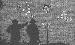
This illustration presents a view that was used by the Phoenicians and will be used for celestial navigation in the northern hemisphere for millenia to come.Changes are very small,about .2 deg.+or-/100 years.Current offset is .7 degrees and in 2100 will be .5 degrees.

Magnetic North,the direction that the needle points to on a magnetic compass,moves around a whole lot more and in a much shorter timespan,due to Isogonic Drift.

Only a bearing based on celestial observation will remain relatively unchanged over the time frame of the stone maps.

If the mapmaker added the "8-N-P" as a celestial observation,with "8" being a bearing to a fixed point,that would make Rex Western's theory wrong.
If,however, the mapmaker added the "8-N-P" as a magnetic variance observation(the observed variation between true and magnetic north),that would make RW's theory correct,as well as give us a date for the addition of the inscription.


Regards:SH.
 

Attachments

  • north star and north pole.jpg
    north star and north pole.jpg
    24.8 KB · Views: 444
That is an absolutely impossible situation. Before 1903, no PRIEST, nor anyone else
knew about magnetic declination DRIFT. Therefore, whatever they used 8-N-P for,
would not be correct today. Plus, you would have to know the exact date the stones
were made, in order to figure it out properly.

IF, THE 8-N-P WAS A CORRECT DECLINATION THAT WOULD WORK TODAY, THE
ONLY WAY THAT WOULD BE POSSIBLE TO CALCULATE IS IF THE PERALTA
STONES WERE MADE AFTER 1904. (Prior to that, they did not know it changed by
the year - the drift).

In fact, 8-N-P - is a line declination (that's where the word declination comes from) which
means, it could mean anywhere, north to south - along that line. Could be in Montana,
could be in Arizona, could be in Baja, California.

us_d_contour.jpg


If the declination is correct, today - then someone in recent history (after 1904)
back dated it to be correct.

I have never even seen a Jesuit Map that has a magnetic declination marked on it.

Beth
 

Hmm, well to toss yet another monkey wrench into the whole 8-N-P issue, consider this; the ancient compasses used by navigators didn't have 360 degrees marked on them, they had either 64 or 32 POINTS - so it could be "8" "Norte" "Puntos" which would mean eight COMPASS points north, not eight degrees which would be "grados" anyway.

Then we would have to figure out if it were a 64 or a 32 point compass........of course then the whole issue of the magnetic declination DRIFT would not be a factor, since it is not a device to illustrate what the mag declination is but a compass bearing for a landmark or site, and would support the stones being real instead of looking like extra effort on the part of a faker.
Oroblanco

A compass rose for a 32 point compass, to illustrate what we are talking about - note there is no 360 degrees!!! It has the degrees marked off by TENS not by ones or even fives, so an "eight" degree declination would be a rough guess job by the user.
Compass_thumbnail.jpg
 

Here is a 64 point compass rose
compcrd3.jpg


Here is an 18th century bearing compass
Bearing_compass.jpg


Food for thought?
Oroblanco
 

"so it could be "8" "Norte" "Puntos" which would mean eight COMPASS points north"
Good observation Roy.I'd go with that,especially with the 8 of a 32 point compass pointing directly to what I believe is the main landmark on the maps.That was one of the "doubtful aspects" on my short list.

"Before 1903, no PRIEST, nor anyone else
knew about magnetic declination DRIFT"
I think that we have eliminated knowledge of "drift" as the reason for the "8-N-P" Beth.
Declination was a phenomenon well known to navigators in the days of Columbus. At that time it was merely calculated and compensated for by the pilot,using the method that I outlined previously.It's one of the reasons that the Portuguese were renown pilots(navigators) in the early days of european exploration and colonization.The fact that we can now predict what the declination will be in the future for a given point,and even calculate what it was in the past has nothing to do with what someone noting the difference between true north and magnetic north marked on the stone.It does, thanks to modern knowledge,allow us to calculate the date to which "8" "Norte" "Puntos" would apply.

"IF, THE 8-N-P WAS A CORRECT DECLINATION THAT WOULD WORK TODAY"
It is not correct today,nor was it correct in 1904....but it was correct for the mapmaker's location in 1768.

Accurate navigation by magnetic compass is more difficult because of all the variabilities,which is why pilots were entrusted with the task,and incidentally, why airplane drivers are called pilots as well.Its what helps us to find a particular mountain,or miss one(something an aircraft pilot would rather do).

Regards:SH.

Gotta make a course to the old rockpile now...take care.
 

Top Member Reactions

Users who are viewing this thread

Latest Discussions

Back
Top