The Peralta Stones

Hi Mike:
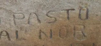
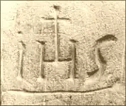
I had wondered if wear could have been responsible for the missing section,as was evident with that of the right side of the inscription.
That seemed to be the case when I enlarged published photos of the stones,as with this example.
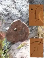
I had a good look in April,but through the glass,and it did not seem to have suffered as much wear in that area.Perhaps the crossbar was not cut as deep as the rest of the "A" to begin with... :icon_scratch:...Did you happen to get a photo with your microscope? I managed to get a very clear closeup in April of similar magnification,and,while it possibly shows a very faint horizontal line,the area in the middle of the A was never carved to the depth of the other lines to begin with.Nor does enough wear seem to have occurred to that area of the inscription.This closeup is angled downward,to better show the amount of wear present.

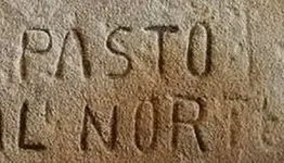
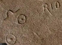
Any thoughts as to the reduction in the font size of the word "PELIGROZA" on the Priest side?

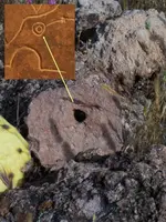
A close look at the differing style of the "1" and the "8" within the heart cutout may raise a question or two as well.It is obvious,as you have observed, that most,if not all of the carving was done with sharpened iron tools,drawn repeatedly across the stone.Nowhere is this more evident than with the "1847",something that obviously required a greater degree of effort on the part of the carver.The point of the "1" seems misplaced for some reason.Not likely due to error IMO.The "8" looks more like a pair of "circle in circles" as well,which could be the reason for the size and style of the inscription.

Regards:SH.
 

Attachments

  • wear area.jpg
    wear area.jpg
    72 KB · Views: 739
  • Closeup of A.jpg
    Closeup of A.jpg
    84.6 KB · Views: 745
FOOD FOR THOUGHT: Spanish explorer Juan de Oñáte camped on the banks of the Río Grande and crossed a site west of the present downtown area which he called "El Paso Del Río del Norte", meaning the cropping of the river. This was the first use of the name "El Paso". The Spanish ruled this area for nearly 300 years. México took over El Paso in 1821 and in 1827 Juan María Ponce de León built the first house on the north bank of the Rio Grande. Thirty years later, El Paso acquired its first post office and stage line.

Texas won its independence from MĂ©xico in 1836 and claimed the Rio Grande as part of its southern border. This area, however, remained part of MĂ©xico until the end of the Mexican-American War in """"((((1848))))"""". More significantly than daily insults, many New Mexican citizens feared that their land titles, issued by the Mexican government, would not be recognized by the United States. They worried that American sympathizers would prosper at their expense. Following Kearny's departure, dissenters in Santa Fe plotted a Christmas uprising. When the plans were discovered by the US authorities, the dissenters postponed the uprising. They attracted numerous Native American allies, who also wanted to push the Americans from the territory. Revolt
Taos Massacre
On the morning of January 19, """"((((1847))))"""", the insurrectionists began the revolt in Don Fernando de Taos, present-day Taos, New Mexico. They were led by a Mexican, Pablo Montoya, and a Taos Pueblo, Tomás Romero, also known by the New Mexicans as Tomasito (Little Thomas).

Romero led a Native American force to the house of Governor Charles Bent, where they broke down the door, shot Bent with arrows, and scalped him in front of his family. After they moved on, Bent was still alive. With his wife Ignacia and children, and the wives of friends Kit Carson and Thomas Boggs, the group escaped by digging through the adobe walls of their house into the one next door. When the insurgents discovered the party, they killed Bent, leaving the women and children unharmed.

The Indians killed and scalped several other government officials, along with others seen as related to the new US territorial government. Among those killed were Stephen Lee, acting county sheriff; Cornelio Vigil, prefect and probate judge; and J.W. Leal, circuit attorney. "It appeared," wrote Colonel Price, "to be the object of the insurrectionists to put to death every...man who had accepted office under the American government."

Arroyo Hondo and Mora massacres
The next day a large armed force of approximately 500 Mexicans and Indians attacked and laid siege to Simeon Turley's mill in Arroyo Hondo, several miles outside of Taos. Charles Autobees, an employee at the mill, saw the men coming. He rode to Santa Fe to get help from the occupying US forces. At the mill eight to ten mountain men were left for defense. After a day-long battle, only two of the mountain men, John David Albert and Autobees' half brother Thomas Tate Tobin, survived. Both escaped separately on foot during the night. The same day Mexican insurgents killed seven American traders who were passing through the village of Mora, New Mexico. At most 15 Americans were killed in both actions on January 20.
 

One of the coincidental things that made me suspect that the lack of a crossbar may have been deliberate.The inset map portions show the more obvious coincidences,though.The stone itself is of the same kind as the Heart Stone.I found two and there are possibly at least sixteen more out there.Note that the final one,found where the last "circle in circle" is on the upper trail map,has no "V" and the hole is near the center of the stone(also of the same kind as the Heart Stone).From that second position one can see the mound below,as well as the hillside heart.Beyond,and overlooking the trail,is the triangle with the unique slash which is not anything like a trail.

Regards:SH.
 

Attachments

  • Marker 01.jpg
    Marker 01.jpg
    39.6 KB · Views: 745
  • final marker.jpg
    final marker.jpg
    135.2 KB · Views: 729
How'd that "Rainbow Party" go Santa?
Got some pics to show us?

SH. :headbang: :laughing7: :laughing7: :laughing7:
 

Morning Gullum : I thank you for the picture of the "8", it confirmed that the "8" was cut first. Check for similar anomalies on the rest of the lettering, This may be the key ?

Don Jose de La Mancha el *Tropical Tramp*
 

Mornin Don Jose:
Apparently the number Eight represents regeneration or resurrection.Therefore it may very well have a bearing on how the stones are to be read.
So,what do you think that it might mean as part of the word "COBOLLO".
You might like this as well.

Regards:SH.
 

Attachments

  • IHS sig.jpg
    IHS sig.jpg
    90.6 KB · Views: 1,037
Coincidental as well that a large uplifted outcropping of "heartstone shale" can be found at the base of the "Priest".
Another sample from the same area.
Interesting as well,that the stone in the inset (previous post)is of a rock quite similar to the H/P stone.It also features a notch similar to that of the Stone "title" Cross as well as a hole similar to that of the upper map stone.
.....SH.
 

Attachments

  • 100_0576sm.jpg
    100_0576sm.jpg
    293.3 KB · Views: 698
Another "example" of a similar IHS carved in stone....SH.
 

Attachments

  • IHS stone.jpg
    IHS stone.jpg
    21.9 KB · Views: 689
There is a deep "cut",sometimes called the "heartcut" on the Horse.This is a photo shot of that "cut"....SH.
 

Attachments

  • heartcut.jpg
    heartcut.jpg
    76.4 KB · Views: 682
Hey SFNM - how bout sticking to the topic and not just posting random historical information unless you explain how it's tied to the topic?

I don't think anyone has heard how the outing went in April where you shared all your findings with a group out in the Superstitions? How did it go and what's the status on your treasure trove permit?

Thanks
 

Hi All,

I am under the impression that some of you are lost. I have had quite a few years working with the stone maps and the geographical area where these maps were meant to be used. I also possess a knowledge pertaining to certain information that was removed from the maps before they were presented to the public, and I will share some of this information at a later date.

The stone maps were made for two reasons;

1. If deciphered properly one will be able to locate the cache(s) if you use the maps in the correct geographic location. One will never solve the stone maps without the information found in the SARA on site as you must spend literally years locating them and then wait until the sun and/or moon are positioned in the right place to produce the clues made by the shadow writing that J. Frank Dobie was talking about. The "B" was created first to confirm the fact that shadow writing was placed on these SARA monuments to be permanent. The creators of the stone maps placed the "B" on the map so as it would create an "8" when a light source from a particular angle (shadow writing) produced the illusion. See attached photograph (one day, one moonlit night) for multiple samples related to "shadow writing". A heart, lightning bolt (death trap), masonic square, the number 4 and 7, the number nine with crescent moon located on top, the letter R. This information is vital to solving the stone maps! Notice the three eye catchers made of rock, each one the size of a pickup truck and they had to position these three rocks perfectly in order to shine like 3 mirrors set in the sun to get your attention while hiking along the trail. The above listed symbols can only be seen at certain times of the year and by the way this monument is a SARA.

2. These maps were made to mis-direct everyone and send us all to the Superstions so as to lead us away from the actual area where the depositories are actually located. The stone maps were introduced to us when they decided it was time to keep people out of the depository areas. The stone maps were not found by accident, this was all well planned my friends. These treasures are not related to the LDM in any way.

If you need any help with transferring the horse from the stone map to the 1900 Florence Topo let me know. It is actually very simple.

Ellie B.
 

Attachments

  • Rrock [Desktop Resolution].jpg
    Rrock [Desktop Resolution].jpg
    91.3 KB · Views: 675
  • Rrock@nite [Desktop Resolution].jpg
    Rrock@nite [Desktop Resolution].jpg
    76.7 KB · Views: 680
Hi Ellie:
A mason would probably be just as thrilled to find something out there as anyone else,I suppose.I'll ask you the same question as I asked Don,therefore.
If the "B" is also an "8" what do you think that it might mean as part of the word "COBOLLO".
Also:
What would "COBOLLO",or any of the other inscriptions say when viewed as "SARA" inscriptions?
Why does the "R" in "RIO" on the Horse Stone look like this,different from the other R's?
What do the two circle-dots and the buried symbol on the left panel of the Horse Stone indicate?
Why are the circle dots used only on the Horse Stone and no other?
Why would the USGS draw a horse on a topo map?...unless they were in on it too. :dontknow:

Thanks in advance for your replies:SH.
 

Attachments

  • Horsepanel R.jpg
    Horsepanel R.jpg
    56.6 KB · Views: 635
somehiker said:
Hi Ellie:

A mason would probably be just as thrilled to find something out there as anyone else,I suppose.I'll ask you the same question as I asked Don,therefore.
If the "B" is also an "8" what do you think that it might mean as part of the word "COBOLLO".
Also:
What would "COBOLLO",or any of the other inscriptions say when viewed as "SARA" inscriptions?
Why does the "R" in "RIO" on the Horse Stone look like this,different from the other R's?
What do the two circle-dots and the buried symbol on the left panel of the Horse Stone indicate?
Why are the circle dots used only on the Horse Stone and no other?
Why would the USGS draw a horse on a topo map?...unless they were in on it too. :dontknow:

Thanks in advance for your replies:SH.

Somehiker,

A typical Mason has no idea what these stone maps even mean, unless he is interested in the stone maps the way that we are.

1. The “B 8” simply states “Shadow Writing”, in other words the symbols are hidden until the shadows make them appear. The SARA will not give up any clues until the proper time of year, only then will we be able to interpret the symbols created by the shadows. The number “8” means to be re-born and the SARA is re-born twice a year.

2. Cobollo will not be found written on a SARA, but its head will be displayed and very much recognizable. One of my favorites actually has an animated flowing mane produced by the shadows.

3. R in RIO is used as a line or pointer, the same for the letter M on the horse’s mane and the crossbars on two of the “A’s” also located on the horse map. See “R” on attached photograph in map area (70% phase).

4. Dot within a circle can mean gold (Au), or the sun (astronomical) or the Son of God or God who is worshipped. The “hat” symbol means tunnel entrance nearby or buried close by. Some say it is the Greek symbol, the alpha and the omega.

5. I believe they were in on it (my theory), for who else would have been able to enhance the area? The four 7.5 quads that contain the horse’s head are; Picket Post, bottom right; Iron Mountain, upper right; Florence Junction, lower left and Weaver’s Needle, upper left. Try putting these four 7.5 topo maps together and re-draw the horse. It can be done, but it is difficult.
Hope this info. Helps,

Ellie B
 

Attachments

  • fog2 [Desktop Resolution].jpg
    fog2 [Desktop Resolution].jpg
    73.9 KB · Views: 612
Ellie Baba said:
Hi All,
.... These maps were made to mis-direct everyone and send us all to the Superstions so as to lead us away from the actual area where the depositories are actually located. The stone maps were introduced to us when they decided it was time to keep people out of the depository areas. The stone maps were not found by accident, this was all well planned my friends. These treasures are not related to the LDM in any way.....
Ellie B.

EB, I can accept the misdirection explanation, but the question then becomes: why would these stones also provide a true, even if heavily coded, solution to the location of the caches? After all, the caches are not 'lost' to them. When I've asked BB, JL, JW and others, "Other than for disinformation purposes, why would these guys provide clues for people to find that were actually valid?", I've never gotten a totally acceptable answer. Do you have an answer?
 

Would you call this a "masonic square",Ellie?
There was something man-made inside,btw.....SH.

What,exactly,is the contents of your "depositories"?
Who did it originally belong to?
Why have they not recovered it?
 

Attachments

  • sqare opening.jpg
    sqare opening.jpg
    142.9 KB · Views: 606
This rectangle,cut in solid basalt,has an "R" in the middle as well.It is always in shadow.
Looks pretty old to me.....SH.
 

Attachments

  • Rectangle R.jpg
    Rectangle R.jpg
    75.7 KB · Views: 605
May be connected to what is in this photo,taken nearby.
This is at the end of one of the trails that branch from the PELIGROZA trail.
....SH.
 

Attachments

  • ledges.jpg
    ledges.jpg
    282.9 KB · Views: 607
Springfield said:
Ellie Baba said:
Hi All,
.... These maps were made to misdirect everyone and send us all to the Superstions so as to lead us away from the actual area where the depositories are actually located. The stone maps were introduced to us when they decided it was time to keep people out of the depository areas. The stone maps were not found by accident, this was all well planned my friends. These treasures are not related to the LDM in any way.....
Ellie B.

EB, I can accept the misdirection explanation, but the question then becomes: why would these stones also provide a true, even if heavily coded, solution to the location of the caches? After all, the caches are not 'lost' to them. When I've asked BB, JL, JW and others, "Other than for disinformation purposes, why would these guys provide clues for people to find that were actually valid?", I've never gotten a totally acceptable answer. Do you have an answer?

Somehiker,

It has taken me 25 plus years to get where I am today. I am pretty sure where the big one is located and a few others are not too far away. A recovery would be great if you could prove that the treasure is still there. We have spent so much money and wasted so many hours using state of the art equipment that led us to believe that something was buried and after digging a 30 plus foot deep hole (30’X 30’) and all we found was an open, empty 3’X2’ metal box. I have dug so many holes that I have become a professional hole digger. This scenario plays out over and over again. No one wants to invest in a “still could be there treasure”. We dug one last week over 6’ down (3’X4’) and dropped in the detector and nothing. I am too old for this stuff and I am worn out. Exploration and mining for gold pays better money and puts food on the table.

Even if someone had all the information on the stone maps deciphered and knew exactly where the treasure is hidden would it be worth risking your life to recover it? Death traps are for real and some of these hiding places are on certain lands that make it impossible to pull off a recovery. The really big treasures out there belong to somebody and they will protect them any way they can. That’s all I have to say about that.

The information on the stone maps has worked very well to serve their purpose as only a few people have been privy to what I have laid out and most of them are dead and/or getting ready to meet they're maker and I am not too far away myself. So far I have only presented the tip of the iceberg, wait until you see what comes next! Who is willing to walk over 10 square miles of what we call “Hell’s Kitchen”? And do it in the middle of summer hiking over some of the roughest, loosest shale, cholla everywhere and infested with some of the biggest rattle snakes on earth. These people were very smart in designing the SARA because the only time you can read them is in the middle of the summer (the important ones that is). I now have found a way to solve this very problem and we are still putting it all together.

I had a friend of mine in New Mexico a number of years ago who was a geophysicist hired by a group of treasure hunters and they had found a big one. He called me at work from the site and he was scared ____liss because the Army and the National Guard had shown up, kicked them off of the property, some arrested, a chain link fence was thrown up and military type NO TRESSPASSING signs went up around the perimeter. Later when he returned to Oregon he called me and said that he had heard of this very thing happening to other folks and could not believe it; well, he does now.

I love to solve problems and mysteries and my wife keeps swearing at me because I have allowed a mistress to come into our lives and screw everything all up. That my friends is why I am divorced and single, until I can convince my mistress to marry me!
There is more to the answer my friend. I will write more later; coffee is ready, hot dog!

Ellie B
 

Ellie Baba said:
.... There is more to the answer my friend. I will write more later ....

Ellie B

Well, the long-awaited book we were expecting will now apparently not be written, so hopefully you can provide some conjecture for us grey beards to mull over before it's time for our dirt naps too. The younger generations ought to be curious about all this, but I suspect if they've noticed, they're only amused.
 

Top Member Reactions

Users who are viewing this thread

Back
Top