The Peralta Stones

Underground religious dwellings

Holy men and women throughout history have lived in caves. "Shrines developed around caves where the dead were buried, and many monasteries were built into cave structures. There are also a great number of cave churches, like those in Cappadocia in Turkey, the chapel in Agios Niketos, in Crete, the rock-cut church of Dayn Aboo Hannes in Egypt, the chapel at Gethsemane, the Grotto of Bethlehem, the Grotto of the Ascension on Mount Olive, the Cave of the Sepulchre, and the Dome of the Rock, which is above a cave."

There also are caves in France and Spain that have a number of rock-cut churches, as well as in Ethiopia, where there are hundreds of Orthodox Christian shrines and churches. Lalibela, for example, is carved out of the pink tuff mesas in Ethiopia. Petra, in Jordan, can be reached through a deep rock cleft. India and Afghanistan have cave temples, and Sri Lanka has tiered temple caves. Meteora, in central Greece, is a well-known rock monastery.
 

ORO WROTE: """""((((I just can't see either the seven caves/cities or the mine or mines in the photo or any where near weavers needle))))""""" Ok ORO have you heard the one about the ------- """"blind man in a store""""
A blind man walks into a store with his seeing eye dog. All of a sudden, he picks up the leash and begins swinging the dog over his head. The manager runs up to the man and asks, "What are you doing?!!" The blind man replies, "Just looking around." :dontknow:
 

Also ORO WROTE: """"have you identified a valley or canyon in the Superstitions as the Valle de los Corazones?"""" Same answer as above: """"blind man in a store"""" :sign13:
 

How would that (underground religious chambers) tally with the descriptions given by de Niza and Coronado? They seem to have been talking about above-ground settlements, not underground caves; in fact they defended the cities against Coronado by climbing up to the upper levels of the buildings. Or are you saying you have found a religious center in the Superstitions, not meaning the actual cities?

Sign me confused again,
Oroblanco
 

ORO WROTE: """"They """"((((seem))))"""" to have been talking about above-ground settlements, not underground caves; in fact they defended the cities against Coronado by climbing up to the upper levels of the buildings. Or are you saying you have found a religious center in the Superstitions"""" ------- "Tell me what I am"
A snake and a rabbit were racing along a pair of intersecting forest pathways one day, when they collided at the intersection. They immediately began to argue with one another as to who was at fault for the mishap.

When the snake remarked that he had been blind since birth, and thus should be given additional leeway, the rabbit said that he, too, had been blind since birth. The two animals then forgot about the collision and began commiserating concerning the problems of being blind.

The snake said that his greatest regret was the loss of his identity. He had never been able to see his reflection in the water, and for that reason did not know exactly what he looked like, or even what he was. The rabbit declared that he had the same problem. Seeing a way that they could help each other, the rabbit proposed that one feel the other from head to toe, and then try to describe what the other animal was.

The snake agreed, and started by winding himself around the rabbit. After a few moments, he announced, "You've got very soft, fuzzy fur, long ears, big rear feet, and a little fuzzy ball for a tail. I think that you must be a bunny rabbit!"

The rabbit was much relieved to find his identity, and proceeded to return the favor to the snake. After feeling about the snake's body for a few minutes, he asserted, "Well, you're scaly, you're slimy, you've got beady little eyes, you squirm and slither all the time, and you've got a forked tongue. I think you're a lawyer!"
 

Attachments

  • th_theheartblanco.jpg
    th_theheartblanco.jpg
    6.1 KB · Views: 901
  • th_theheartblanco.jpg
    th_theheartblanco.jpg
    6.1 KB · Views: 907
An Ancient Practice
People have been hollowing out caves to make their homes for many thousands of years. We all need shelter from the elements, and it didn't take long for our ancestors to run out of available real estate in natural caves. In certain parts of the world, it was easier for prehistoric people to carve out warm, dry spaces than to use other building methods. Houses were cut into soft sandstone cliffs in China and the Middle East, and into volcanic ash and lava flows on Pacific islands. Indigenous peoples of North America built elaborate cities under cliffs.

While many of these ancient structures are still standing, and a few are still inhabited by contemporary residents, there are also people experimenting with the benefits of modern cave living. And what may surprise you is that many of these homes are well appointed, with modern conveniences, good ventilation and even spectacular views. Most of them cost less than conventional housing.

As anyone who has ever visited a natural cave knows, underground spaces are naturally quiet and maintain a constant temperature, cool in summer and warm in winter. Plus, their primary structure is all-natural material, and it is as locally sourced as it could possibly be. Cave homes certainly aren't available everywhere and may not be for everyone, but they are a good reminder of what's possible when we think outside of the ticky-tacky box.
 

""""This large ((((cavern)))) in the Superstition Wilderness Area""""
will probably be explored one day and turn out to be
another Arizona natural wonder. Until then, the """"secrecy""""
of its location protects it from vandals."""" Quoted From Tom Kollenborn. Do you believe in cavemen?’

Sceptics think ‘gotcha!’ when they ask this question. They might know the Bible says that Adam’s descendants built great cities, but they claim the ‘evidence’ clearly shows that early humans lived in caves.

‘Of course we believe in cavemen,’ we respond, ‘if by “cavemen” you mean people who live in caves.’ Just visit the town of Coober Pedy in South Australia, where opals are mined—it’s so hot that some miners live in underground houses. Real live ‘cavemen’ with TV sets!
Well, we answered the question. But the question is not really about cavemen at all. It’s about those hairy, cave-dwelling ‘apemen’ so often depicted in books and museums. People assume, based on their evolutionary beliefs, that humans who once lived in caves were primitive brutes. But this is not a deduction from the evidence; rather, it is a consequence of evolutionary conditioning. Even the caves occupied by Neandertals show clear evidence that they were skilful human beings, even talented musicians.

The Bible describes a number of ‘cavemen’. In Genesis, we find that Lot was once a ‘caveman’ (after he fled Sodom). When David was running from King Saul, he lived in a cave. Obadiah hid a hundred prophets in a cave and fed them bread and water, to save them from Jezebel. To escape the Midianites, the Israelites lived temporarily in caves. Elijah himself lived in a cave. Even Job mentions people who lived in caves (Job 30:6).

From the viewpoint of biblical history, as people spread out after the confusion of languages at Babel, they would have constructed a variety of homes—some temporary and some permanent—such as tents, or made of mud, stone or wood, and many people would surely have taken up residence in caves. Thus, you would expect evidence all over the world that people lived in caves.

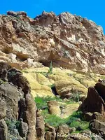
One interesting example comes from the island of Malta, south of Sicily in the Mediterranean Sea.

Mediterranean people have always liked caves and grottos as convenient and cool dwelling places. Malta is no exception. Here, the tradition of cave dwelling goes back to antiquity. There is strong archaeological and documentary evidence that cave dwelling, or troglodytism, was very popular during medieval times, too. When Jean Quintin d’Autun wrote about the island in 1536,1 he was surprised by the great number of cave dwellers in Malta; and there were still some people living in caves till very recent times. The remains of several of these cave settlements are still present, including some that had cave churches
The Great Cave
Ghar il-Kbir (the Great Cave) is the best-known of these settlements.2,3,4,5,6 It consists of eight smaller caves, on two different levels, surrounding a large natural cavern. The roof of the cavern (technically called a ‘karst hollow’) has collapsed. The cave dwellers inhabit the smaller caves, having built stone walls inside (as well as at the entrance) to separate their living quarters. There is no evidence of wall painting (which is found at some other sites), but there are various works in stone—loops in the ceiling, ducts, shelves and niches, which evidently served practical purposes.

The date of the earliest settlement at Ghar il-Kbir is unknown, but the first known mention of it, in 1544, is a reference to Simone Camilleri de gar il-chibir (Simone Camilleri of the Great Cave). The Maltese historian Giovanni Francesco Abela includes Ghar il-Kbir in his list of inhabited places on the island. He describes it as a vast cavern where 117 people lived, grouped in 27 families.7 They were pastori e pecorai—‘shepherds and sheep-herders’.

The most dramatic description of life at Ghar il-Kbir is given by the German scholar Athanasius Kircher (1602–1680) in his voluminous book Mundus Subterraneus (Latin for ‘World Beneath the Earth’).8 When he visited the place, tall, strong and simply dressed children and adults greeted him. He also noted that the women were remarkable for their good looks (which contrasts markedly with the pictures of brute and coarse women in children’s books!).

The people were vegetarians, eating vegetables, cheese and home-baked bread, and using dried cow dung to fuel their fires. The men worked in the fields and tended animals, which were taken to town for sale. The women took care of the children and made cheese. Drinking water was stored in large earthen pitchers. The cavern was ventilated by shafts, devised to exclude rain and wind. The cave dwellers decorated the caves with crosses and holy pictures.

A first-hand ‘tourist’ account
Ghar il-Kbir became a mini–‘tourist attraction’ among the travellers of that day. Imagine visiting a real-life community in a cave. The published account of a German visitor, Athanasius Kircher, was most vivid:

‘In 1637, when I was in Malta, … [my host mentioned] that there was a hill in the vicinity where people who were his subjects live underground. He expressed the wish that I go and see them and admire the art with which they adorn these caves and how they organize the place where they live. …

‘[T]hey had truly well-organized rooms. … Here they have a bed dug out of solid rock. There, in the wall, they have a wall cupboard where they keep bread and cheeses. In another place they have pens for cows, sheep, and donkeys; and some hens as well. Pottery jars, large enough to hold water instead of cisterns, were not lacking. Onions and garlic, tied in bundles like festoons were hung up, adorning the walls.

‘There were also ovens for baking bread. … The ovens also have chimneys, otherwise … smoke would spread in the cave and the people would suffocate. …’1

The population gradually decreased, but some inhabitants still remained there at the beginning of the nineteenth century. According to popular accounts, the British colonial government forcibly expelled the last residents in the 1830s and resettled them in nearby villages.

The church records in the nearby village of Dingli include personal details of the people who lived at Ghar il-Kbir.2 For example, in 1699, a 53-year-old man named Franco Vella lived there with his 38-year-old wife, Filumena, and their three children.

Clearly, these cave dwellers were normal people who interacted with nearby villagers. While the noble and rich lived in palaces, the ordinary people lived in stone houses or in caves. These cave dwellings could not compare in architectural beauty with the nearby Verdala Palace, but during the hot summer months, the caves were surely more comfortable than anywhere else on the island.
 

The legend states Geronimo and his followers entered a cave, and the U.S. soldiers waited outside the cave entrance for him, but he never came out. Later it was heard that Geronimo was spotted in a nearby area. The second entrance to the cave has yet to be found and the cave is still called Geronimo's Cave. At the end of his military career, he led a small band of 36 men, women, and children. They evaded thousands of Mexican and American troops for over a year. GERONIMO, THE GREAT APACHE CHIEF USED THIS CAVE LOCATED IN THE SUPERSTITION MOUNTAINS OF ARIZONA AS A STRONG HOLD. NOT EVEN THE US ARMY WOULD GO UP AGAINST IT. STRATIGICALLY LOCATED WHERE IT WOULD BE CERTAIN DEATH FOR ANY INVADER TO ATTACK. Geronimo was reported seen stepping into rock walls and disappearing .......
The Apaches believed themselves to be the first and superior race. In some respects they were superior. They excelled in activity, cunning, endurance, and cruelty. The stories of the feats of men running a hundred miles in a day come down to us from the days of Coronado and from the old officers of the army who were formerly stationed in that country. Their lung power enabled them to start at the base of a mountain and run to the summit without stopping. An account of their atrocities and raids would fill a volume. Once numerous and powerful, by almost constant warfare they have become greatly reduced in numbers.

They had an abundance of arms and ammunition, for they not only raided and plundered stores, ranches, and freight trains, but they could """"((((completely conceal themselves))))"""" with grass, brush, and feathers, and lie in ambush in ravines near the trail, so that the prospector, miner, ranchman, or traveler would never observe them until he felt the deadly bullet from their rifles. In this way they kept themselves well supplied with whatever they required. Their endurance was most extraordinary. When hard pushed and driven to the higher peaks of the mountains they could subsist on field-mice and the juice of the giant cactus. They would go to their reservations and agencies for a time to replenish their wants and recruit their members; then return to the warpath. Their docility and meekness while peaceable was only excelled by their ferocity and cruelty when at war.

For a few weeks or months they would be "horny-handed sons of toil," and then for an equal time they would be red-handed assassins and marauders. They were at times composed of the Yumas, Mojaves, White Mountains, and Chiricahuas, the last named being the dominant and most warlike tribe. They inhabited the most rugged and inaccessible regions of the Rocky and Sierra Madre mountains. When pursued they would steal horses in one valley, ride until they exhausted them, and then destroy or abandon them, travel on foot over the mountains, descend and raid another valley, and continue this course until they felt themselves free from their pursuers. They recognized no authority or force superior to their own will.
 

Attachments

  • th_theheartblanco.jpg
    th_theheartblanco.jpg
    6.1 KB · Views: 867
  • th_theheartblanco.jpg
    th_theheartblanco.jpg
    6.1 KB · Views: 870
An old post from another site,but I wonder if SF has found these markings during his Googley-hiking.
I somehow doubt it. ::)

Heidi
Post subject: palo-indian
PostPosted: Mon Jan 20, 2003 4:44 pm
Offline
Greenhorn

Joined: Thu Jan 16, 2003 4:25 pm
Posts: 15
Location: Ramona, CA
Mr. Hawkins,
I believe your archeologist friend is wrong about the markings at twin
buttes being palo-indian. I don't believe there is even a remote chance of that being so. It is unlikely they are more then three hundred years old.

You say you think the stone maps are fake. If that is true, how could they be part of the markings at twin buttes? Are there a lot of people who knew about these markings prior to the fifties? I have read a lot of the books on the Lost Dutchman, and have never read anything about these markings. You said that you thought the markings at twin buttes were at leas two hundred years old. What about the possibility that the people that made those markings and the ones who made the stone maps are the same Spaniards. If the original markings were made around two hundred to three hundred years ago, they could have been done by the Jesuits and if that's true, the stone maps may have been made around the same time. If the Peralta family knew this information, they could have added the 1847 in that year and it's possible they had possession of the stone maps also. Does that all make since to you? It seems to me that I have read that Hog canyon was monumented and somewhere in this forum, I think someone mentioned riding to the top of it. I don't think there would be a single record of the Jesuits being trained in any mining techniques, because the Jesuit Order claims they did no mining whatsoever. Only souls.
H
 

Apache leader Geronimo found a mine left by Spanish church officials. Geronimo swore his warriors to secrecy and told them anyone who revealed the location would be punished by death. Today, it is said that a few elderly Apaches are still alive who allegedly know the location of this mine, but refuse to tell it for fear of reprisal. They claim there are hundreds of gold bars still stacked just beyond the entrance to the shaft. They also claim no white man will ever find the mine.
 

Attachments

  • stonemaps.jpg
    stonemaps.jpg
    32.8 KB · Views: 909
  • stonemaps.jpg
    stonemaps.jpg
    32.8 KB · Views: 859
The cave where the Apache Indian leader Geronimo is """"((((rumored))))"""" to have hidden from the U.S. Cavalry.
During the late 1800's southern Arizona was a hot and hostile land. Tombstone had some of histories worst bad men. Also, in that same region there was some of America's most feared Indians. One, being the famous apache leader Geronimo. He was being forced to move his band to the San Carlos reservation. He and a small group escaped and stole horses and made a long ride to Fort Verde. Riding some 70 miles a day, they killed and ate their own horses to survive. While camping in the forest, Geronimo came upon a small band of renegade soldiers smelting gold in the hills some 3-5 miles from the Fort. Watching this day by day he learned the gold smelting process and the value of this yellow metal. Geronimo and his men proceeded to kill the miners. Then they walked to Camp Verde and with the Raw gold, bought each man a 50-70 caliber Spring field rifle with cartridges.
 

Attachments

  • GC.jpg
    GC.jpg
    76 KB · Views: 879
gollum said:
Real de Tayopa (Tropical Tramp said:
Ladies and gentlemen: when the stones were 'made' determines just how sophisticated an audience they would be protecting their secret form. 1800's or prior, would be mostly an uneducated or severely limited ability of solving it..

Maybe we are being too clever in our attempts to solve them ?? Are we reaching the cloud interpretation status in looking for a complex answer, instead of a more simpler one.

As it is, how would you send instructions on solving it to a third party?

Don Jose de La Mancha el *Tropical Tramp*

p.s. after studying the "8 / B" I am convinced that the "8 came first, then the B was cut after."

Hey Jose,

Here is your "B" "8" under low power magnification. This was the lowest magnification available with the digital microscope I had.

Best-Mike


Hey Jose and Mike,

The "B"was carved first, the "8"was created by correct placement of the light source (see rounded upper and lower interior surfaces of stone due to carving of the letter "B").

Ellie "B" or "8", well I just had lunch!
 

Hi Group,

We need to get this stone map location settled. I realize some of you will say that I am full of it. These maps were not meant to be easily solved (try to keep up with me) as some of the maps are not even needed! The maps were designed by at least 14 different people who were all highly educated. They worked together for a number of years just to re-write this version of the stone maps to take the place of the earlier version as the treasures have been moved to a number of safer well protected locations. If you are not familiar with the history of the area and have not walked over every mile of the depository area you will never locate the areas where these treasures were hidden. No Google Earth my friends, as what I have seen presented by many on this site I admit that you guys keep me well amused. Its like giving a child a 5 foot length of fuse and a stick of dynamite. Once he lights the fuse how long will he be able to run before the blast occurs? If you have not been trained to deal with explosives do not mess with something you know nothing about. These people who hid these caches were in the field every day (for years) doing what they did best. You must go where ever they had gone. The answers can only be found on the ground in the field, as I will demonstrate;

How to Transfer Horse’s Head to 1900 Florence Topographical Map

What a day!

Below you will find a couple more clues to help you place the stone maps location derived from the clues on the horse's mane. Joe you are correct in the word MILL. Notice the left leg of the letter M is kicked up. Draw a line and notice that it passes under the horse's eye going through the crescent moon and ending at the "L" in EL Cobollo. The horse's line of site; millsite is located (find on topo map) just southwest of his eye (on Hewitt Ridge, 4,269 ‘) on the 1900 Florence Topographical Map and baseline is just to the north. The crescent shape is located just below Byous Butte at 3,637 feet. Mlll also represents the 111th Meridian and P33 (P from PASTO, A has no crossbar) represents the 33rd Parallel (real close Wayne). Some of you will begin to recognize the horse’s head hidden within the Florence Topo map. His muzzle is located in Queen Creek, go north up Hewitt Canyon and you will form the rest of the muzzle and the cheek as designed by the Florence Topographic map. Between the C and a of Canyon (Hewitt) the lower neckline runs in a southeasterly direction and intersects with Whitford Canyon. To the east of Iron Mountain is Rogers Trough, Rogers Canyon Forms the top of the horse’s ear, go south through Roger’s Trough then southeast to Spencer Spring Creek intersection to Rocky Creek Fork intersection. NOTE: If you take Reavis Trail Canyon south from Roger’s Trough you may notice a familiar part of one’s anatomy. Remember, a symbol may be used in three different ways. I will explain more about this subject later.

I have now shown you how the stone maps were designed to fit this particular area. The depository areas are in to be found within the borders of the 1900 Florence Topogaphic Map; but where? FEMF you wanted a map for location? You now have it.

More to come my friends, the horse on the Florence Topo will move to the east. And now, how about a little trivia for you all; what name did the Spanish use to identify what we call today “Picket Post”? The answer is, “El Tordillo”, the dapple-grey horse. Could this be just a coincidence?

Have great weekend,

Ellie 8
 

Roy,

"Next - how can we be sure the stone maps apply to the Superstitions as you propose? Where is anything marked on the map, that is un-mistakably a landmark in the Superstitions (like Four Peaks, Weavers Needle etc)?"

Both Weaver's Needle and Four Peaks are shown on the Stone Maps. Did you ever look at my overlay map of the Superstitions? The triangle slash is Weaver's Needle. For those who have hiked south towards the Needle, and seen the trail leave the canyon bottom and continue up the west side, it happens exactly were the the trail stops on the Stone Maps. If you were to continue on the same line you were traveling, towards the Needle, you would cross through one of the X's on the Stone Maps.

Just for the record, it would not surprise me if that X isn't Bob Brady's cave of gold bars......and/or what Dale Howard was looking for. Whatever it is, it's directly on that line from what looks like the end of the trail in East Boulder and Weaver's Needle.

If you make it to the Rendezvous this year, I will explain it all in person. Did I send you a copy of my map??? Can't remember S#!T anymore. :dontknow:

Take care,

Joe
 

Ellie Baba said:
Hi Group,

We need to get this stone map location settled. I realize some of you will say that I am full of it. These maps were not meant to be easily solved (try to keep up with me) as some of the maps are not even needed! The maps were designed by at least 14 different people who were all highly educated. They worked together for a number of years just to re-write this version of the stone maps to take the place of the earlier version as the treasures have been moved to a number of safer well protected locations. ....

How to Transfer Horse’s Head to 1900 Florence Topographical Map.....

Ellie 8

So you are saying that these stone maps were created sometime after 1900?
 

Hi Springfield,

Yes, this set of stone maps were made to entertwine with the 1900 1:125,000 Florence Topographical Map. A few years earlier most of the name places on the map did not exist, ie; Reavis, Roger's Trough, Milk Ranch Road, Fraser Ranch, MIllsite Canyon, Elephant Butte, etc. Once you position the horse's head and neck on the 1900 Topo (isn't it interesting that the area outling the horse's head on the 1900 Florence map seems to have been enhanced?). Now, after you have successfully transferred the horse's head to the 1900 map, you will never have to draw it on a 1900 map ever again as you will locate it immediately. Funny that the same thing happens when you discover a SARA. You will be able to recognize them at any phase level.

Ellie B.
 

Hi Ellie:

"“El Tordillo”, the dapple-grey horse. Could this be just a coincidence?"

Not at all,Ellie.The name seems to pre-date the 1900 1:125,000 Florence Topo by quite a few years as well.
It's an apt description of the horse of "Santa Fe". :icon_profileright:

(P from PASTO, A has no crossbar)

The "P" followed by the "A" with no crossbar are important clues IMO.

Regards:SH.
 

Santa Fe NM wrote
After feeling about the snake's body for a few minutes, he asserted, "Well, you're scaly, you're slimy, you've got beady little eyes, you squirm and slither all the time, and you've got a forked tongue. I think you're a lawyer!"

Hahaha - however, we have gone from confusing to lost - and you have successsfully lost me. ??? :dontknow: :icon_scratch:

Ellie Baba wrote
Hi Group,

We need to get this stone map location settled. I realize some of you will say that I am full of it. These maps were not meant to be easily solved (try to keep up with me)

Well you have lost me too. :icon_scratch:

Cactusjumper wrote
Roy,

"Next - how can we be sure the stone maps apply to the Superstitions as you propose? Where is anything marked on the map, that is un-mistakably a landmark in the Superstitions (like Four Peaks, Weavers Needle etc)?"

Both Weaver's Needle and Four Peaks are shown on the Stone Maps. Did you ever look at my overlay map of the Superstitions? The triangle slash is Weaver's Needle. For those who have hiked south towards the Needle, and seen the trail leave the canyon bottom and continue up the west side, it happens exactly were the the trail stops on the Stone Maps. If you were to continue on the same line you were traveling, towards the Needle, you would cross through one of the X's on the Stone Maps.

Just for the record, it would not surprise me if that X isn't Bob Brady's cave of gold bars......and/or what Dale Howard was looking for. Whatever it is, it's directly on that line from what looks like the end of the trail in East Boulder and Weaver's Needle.

If you make it to the Rendezvous this year, I will explain it all in person. Did I send you a copy of my map??? Can't remember S#!T anymore.

Take care,

Joe

Yes I have seen your map overlay, and it is a very good "fit"; however I respectfully disagree that either Weavers needle or Four Peaks is absolutely ID'ed on the stone maps. Likewise, there are two rather significant features on two of the maps, which is ignored by apparently everyone, and they just will NOT fit with any site in the Superstitions at all. One more rather significant problem with trying to tack the stone maps to the Superstitions too - the "mission" - where is there any kind of mission in the Superstitions?

I do not recall your ever sending a copy of your map to me Joe, however if you would not mind re-sending it I would appreciate it.

We are planning on attending, barring some disaster we will be there. I don't like mentioning when we will not be at home on a public forum, but as we have someone to watch the place while we are away, I can say that. We have been robbed twice over the years, which is a good reason not to be making it public info when we are home, nor what we have in our home. I once owned a rare book signed by Jerome Bonaparte (brother of Napoleon I) and of course that vanished with other valuables. I have to think the robber was someone who knew about that book, for I had not mentioned it to many people, and someone who knew when we would be gone. It worries me when some of us mention about some of the rare and valuable things we own, for not everyone on the internet is trustworthy.

Good luck & good hunting amigos, I hope you find the treasures that you seek.
Oroblanco
 

somehiker said:
Hi Ellie:

"“El Tordillo”, the dapple-grey horse. Could this be just a coincidence?"

Not at all,Ellie.The name seems to pre-date the 1900 1:125,000 Florence Topo by quite a few years as well.
It's an apt description of the horse of "Santa Fe". :icon_profileright:

(P from PASTO, A has no crossbar)

The "P" followed by the "A" with no crossbar are important clues IMO.

Regards:SH.

Hey SH,

There is actually a crossbar on the "A", but it is badly degraded (see pic). It's just like the "T" and "E" in Norte (see pic).

Best-Mike
 

Attachments

  • pasto_a1.jpg
    pasto_a1.jpg
    53.4 KB · Views: 735
  • norte_a1.jpg
    norte_a1.jpg
    61.5 KB · Views: 744

Top Member Reactions

Users who are viewing this thread

Back
Top