The Peralta Stones

Good morning Ellie Baba,

As you expand your horizons and your knowledge, you will find out that there can be many more explanations for a symbol. Such as this one from page 32 of a book titled "The Book of Signs," by Rudolf Koch.
S&S pg 32.jpg

There is a lot of knowledge that can be found in books such as these.
DSCN0788.JPG

Sincerely,

Infosponge]
 

cactusjumper said:
Springfield,

My own personal belief about the stones, is that they were created "after the fact". They do show the locations of mines, and possible treasure locations in the Superstition Mountains, to the exclusion of all other places, but those locations no longer hold anything of value. Harry LaFrance's cave of gold bars is the one story that really convinces me of that.

Because of my uncle's, Tracy Hawkins, Ernie Provence and Dale Howard's participation in that story, I believe it to be true. It is located on the Stone Map Trail and is denoted by an X. Because the next X on the trail shows a sealed mine/cave/claim, it's possible it also was a storage place for gold bars.

Another X is shown between Weaver's Needle and Black Top Mountain. That matches up with two stories that I am familiar with. One is Dale Howard's boulder sealed cave with rich ore at the entrance, and the other is Bob Brady's cave of gold bars.
Those stories are also locate on the Stone Map Trail.

That's why I believe my map is on the money.......so to speak. ;D I am always at a loss to figure out why so many people are unable to see the correlation between my maps and the topography which they match so precisely. I always thought I was totally convinced when we found those two monuments on the ridge. That all took second place when we found the old trail with the heart at the end........exactly where I placed it on my topo' over 35 years ago, without ever being at that final location.

I guess you just had to be there......

Take care,

Joe

Joe, every time I hear you speak about those monuments I curse you for not getting photographs :) Of course, I'm guessing you've cursed yourself over many times about them too!!! I don't at all question that they were there - I fully believe they were - what surprises me about them being where you found them is that they still existed then! With the searches that went on for Ruth and other assorted dutch hunting in the area as well as Bark, Ely and Barkley's knowledge of the area, I would have thought those monuments would have been torn down LONG before you ever saw them. Were they missed by others (I doubt it)? Were they in such an area that those who knew about them didn't suspect anyone else would find them?

Heck if I know - I just know I WISH YOU HAD GOTTEN PHOTOGRAPHS :)
 

mrs.oroblanco said:
Springfield,

..... If we are to "assume" that it is a map - having to turn it for ONE symbol, is .......... ridiculous.

B

Yes, ridiculous. If we are hiding something of great value nearby and creating a map leading to it's location, let's, by all means, simplify the map so than any numbskull can retrieve the goods. Better yet, let's leave arrows along the path and a big 'X' where the numbskull should dig. Sorry to be facetious, but the more you are exposed to heavily coded messages, the more you'll realize that the messengers who created them have an advantage that cannot be overcome by accepted logic. These folks are above all masters of human behavior and they know your reaction to things even before you react. If this stuff was easy, there wouldn't be the mysteries that befuddle us.
 

Infosponge said:
.... If the stones are real, they will indeed lead you on a journey to your hearts desire. I do believe (for reasons I will keep to myself at this time) the stones are real, but do not lead to anything in the Superstition mountains. (no offence Cactusjumper or anyone else for that matter) I do not believe the stones are the record of a simple religious journey into the heart of the region, nor connected to Father Kino in any way. .....
Sincerely,
Infosponge

Extremely astute observation, Sponge. The first photo especially is magnificent to say the least. The anchor too is significent. At a certain point in his quest, a seeker of the truth may realize that perhaps the prize is not a cache of gold, whether or not the gold truly exists. If the quest is a vehicle, awareness may be the more valuable destination. On the nuts & bolts level, I also believe that the gold caches exist, but have never been lost.

Just out of curiosity, has your research turned up the name, 'Cuco', especially in relation to the idea of 'monsters'?

Oro: One other thing - I too have wondered if the Peralta Stones may not truly apply to a completely different area, an area with missions, mountains and river, and mines?
Infosonge: Lets just say "I have more than wondered."

Some say that at the 'true location' of Santa Fe you will find Santa Maria, San Jose and Santa Nino together.
 

Howdy Springfield,

Quote from: Infosponge on Yesterday at 10:44:21 PM
.... If the stones are real, they will indeed lead you on a journey to your hearts desire. I do believe (for reasons I will keep to myself at this time) the stones are real, but do not lead to anything in the Superstition mountains. (no offence Cactusjumper or anyone else for that matter) I do not believe the stones are the record of a simple religious journey into the heart of the region, nor connected to Father Kino in any way. .....
Sincerely,
Infosponge

Extremely astute observation, Sponge. The first photo especially is magnificent to say the least. The anchor too is significent. At a certain point in his quest, a seeker of the truth may realize that perhaps the prize is not a cache of gold, whether or not the gold truly exists. If the quest is a vehicle, awareness may be the more valuable destination. On the nuts & bolts level, I also believe that the gold caches exist, but have never been lost.

In the case of the Jesuits, I believe it was lost for the following reasons:

“In 1773. Pope Clement XIV yielding to pressure from the Bourbon courts, fearing the loss of his Papal States, and anticipating that other European countries would follow the example of Henry VIII (who abandoned the Catholic Church and took his whole country with him), issued his brief Dominus ac Redemptor suppressing the Society of Jesus. This religious Society of 23,000 men dedicated to the service of the church was disbanded. The property of the Society's many schools was either sold or made over into a state controlled system. The Society's libraries were broken up and the books either burned, sold or snatched up by those who collaborated in the Suppression.”
http://www.faculty.fairfield.edu/jmac/sj/briefsjhistory.htm

“The Society was restored 41 years after the Suppression in 1814 by Pope Pius VII. Although many of the men had died by then,”
http://www.faculty.fairfield.edu/jmac/sj/briefsjhistory.htm

When the Jesuits were expelled in 1767, other than anything they might have hid was confiscated. It was at least 47 years before any of them returned, so it’s a pretty safe bet that anybody who might have been involved in concealing anything was no longer alive to return and retrieve it.

Just out of curiosity, has your research turned up the name, 'Cuco', especially in relation to the idea of 'monsters'?

So far, only in folklore.

Sincerely,

Infosponge
 

Hi All,

Crescent Cross
In heraldry and art, especially in Pagan symbols, the moon has for a long time been associated with a woman's monthly cycle, a superstition which contributed to Priestess Phobia. Our Lady of Guadalupe

On a Christian Crescent Cross, the whiteness of the moon represents virginity, and in particular, the Virgin Mary, Mother of God.

I thought we were looking for actual treasure signs, are we not? What does this sign say to you? If you had read my earlier post describing that symbols may represent typically three different meanings; I am not seeing how the meaning of pureness and virginity will lead me to a treasure as relating to the signs found on the stone maps. Kino also was an expert when it came to astronomy and this symbol was placed there for a reason. I know that it was used to identify an asterism which is an important clue related to the location of said treasure. The asterism is located in the depository area and its name can still be found on topo maps that are current up to this date.

This information can be found on the Horse Map; His eye is fixed upon the cross, the mirror image of the cross is now a reflection in his eye. What do you see just below his eye? A crescent moon would be my best guess. We now have a cross over the crescent moon, wala! Remember Folks, The Horse of the Holy Faith is not a place, this horse is our guide and he can be found in multiple places all around the depository area. How many of you have a found this horse in the desert or anywhere else for that matter? Step up to the plate people, I am doing just that.

Ellie Baba
 

Attachments

  • Horse Map.jpg
    Horse Map.jpg
    225.1 KB · Views: 753
Info sponge Wrote: "''''I do believe (for reasons I will keep to myself at this time) the stones are real, but do not lead to anything in the Superstition mountains.'''" thats hilarious as mike mcchesney says HA HA HA! Who are you protecting or trying to protect. so this is the hidden agenda Jim Hatt Speaks of, if the ldm is connected with the superstitions who loses who is jeapardized who looks bad who gets harmed by this discovery obviously its more than one person which explains why alot of people are afraid of the dutchman being proved I have the evidence, which when it comes out you who oppose will look like """"liars with hidden agendas"""", and truly be connected to a """"conspiracy to hide the truth, that is the ldm """"is in the supers"""" the stone maps and other ldm maps are directly linked to the supers. "The Apache say the apache sacred cave and the lost dutchmans mine are one and the same." A male rattle snake guards the front entrance and a female guards the rear entrance, are the Apache """"LYING?"""" do the apache lye """"I truly dont believe they do"""" truly what are the repercussions if i or anyone prooves beyond the shadow of a doubt that the ldm is real """"who gets in trouble""" is there legal repercussions or just shame"""" if it was proven to be somewhere other than the supers """"who""" would it protect And How?
 

Attachments

  • th_theheartblanco.jpg
    th_theheartblanco.jpg
    6.1 KB · Views: 613
  • th_theheartblanco.jpg
    th_theheartblanco.jpg
    6.1 KB · Views: 620
Good morning:Sponger that is similar to the sloughed off cliff up on the crest of the sierra, between Sonora / Chihuahua.

Here is one for you to solve, it is in a shallow cave up on Tayopa. Notice the similarity in the triangles and paint.

Don Jose de La Mancha (I exist to LIVE, not live to exist)
 

Attachments

  • Map in a shallow cave at Tayopa ©@.jpg
    Map in a shallow cave at Tayopa ©@.jpg
    47.9 KB · Views: 631
Ellie Baba

You emphatically stated the following: “The cross/anchor symbol on the rock represents Sagittarius;” I was merely pointing out that there are other meanings for the same symbol, nothing more, nothing less.

Sincerely,

Infosponge
 

Dear Santa Fe New Mexican,

You spewed the following:
Info sponge Wrote: "''''I do believe (for reasons I will keep to myself at this time) the stones are real, but do not lead to anything in the Superstition mountains.'''" thats hilarious as mike mcchesney says HA HA HA! Who are you protecting or trying to protect. so this is the hidden agenda Jim Hatt Speaks of, if the ldm is connected with the superstitions who loses who is jeapardized who looks bad who gets harmed by this discovery obviously its more than one person which explains why alot of people are afraid of the dutchman being proved I have the evidence, which when it comes out you who oppose will look like """"liars with hidden agendas"""", and truly be connected to a """"conspiracy to hide the truth, that is the ldm """"is in the supers"""" the stone maps and other ldm maps are directly linked to the supers. "The Apache say the apache sacred cave and the lost dutchmans mine are one and the same." A male rattle snake guards the front entrance and a female guards the rear entrance, are the Apache """"LYING?"""" do the apache lye """"I truly dont believe they do"""" truly what are the repercussions if i or anyone prooves beyond the shadow of a doubt that the ldm is real """"who gets in trouble""" is there legal repercussions or just shame"""" if it was proven to be somewhere other than the supers """"who""" would it protect And How?

May I kindly suggest that you read the U.S. Constitution and the Bill of Rights? In there you will find what is labeled as “the First Amendment,” and it guarantees the right of free speech. I have the right to my beliefs and my opinions, just as you have the right to yours. Obviously you don’t agree with mine, and just to make myself clear “I don’t agree with yours." But the difference between us is where you show no respect for my belief or my opinion, I not only respect your belief and your opinion, but I will fight for your right to state them even if I don’t agree with them. As for you not agreeing with my beliefs or my opinions, that’s your right and I could care less whether you agree with me or not!

Sincerely,

Infosponge
 

FEMF
P.S. Ellie have you seen Marcos name on the East end of South Mountain?


No, and I did not even know that it was there. Thanks for the info. Is it possible for you to indicate the spot using google Earth to include a Lon. & Lat. reference? I sure would appreciate any other material you could provide.

Ellie B
 

Attachments

  • IMG_0087_0156 [Desktop Resolution].jpg
    IMG_0087_0156 [Desktop Resolution].jpg
    67.3 KB · Views: 538
Paul,

"Joe, every time I hear you speak about those monuments I curse you for not getting photographs Of course, I'm guessing you've cursed yourself over many times about them too!!! I don't at all question that they were there - I fully believe they were - what surprises me about them being where you found them is that they still existed then! With the searches that went on for Ruth and other assorted dutch hunting in the area as well as Bark, Ely and Barkley's knowledge of the area, I would have thought those monuments would have been torn down LONG before you ever saw them. Were they missed by others (I doubt it)? Were they in such an area that those who knew about them didn't suspect anyone else would find them?

Heck if I know - I just know I WISH YOU HAD GOTTEN PHOTOGRAPHS"

That was a long time ago, but the events are still something I doubt I will ever forget. There are many things I wish I had paid more attention to, like writing down some of the stories that were being told all around me. Never thought I would forget, or even need the information again.

Once we found the monuments, we became focused on getting down to our camp at Willow Spring......as quickly as possible.
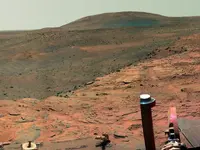
Next time you are there, look straight east and imagine climbing down that ridge.........with a dog.......in the dark. :o I was expecting that we would retrace our steps the next day with Uncle Chuck. Storm came up that night, and Chuck insisted we had to start out of the canyon.

The next time I returned, on my own search, I didn't feel the ney ed to go back to the monuments. I knew where the map was going to end, so that was where I focused my attention. Seemed reasonable at the time. ::) 
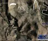
It may be that some of the monuments on that trail are still standing, or at least the bases might still be visible.

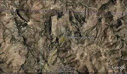
If you were to start at the top of the one (1), just below Tim's Saddle and follow the map/trail to the heart, you would understand why I am so convinced. The map alone should be enough, but many people fail to see how it matches the topography.

Other reasons are the fact that the Stone Map Trail matches Bicknell's instructions to the "T". It was very close to where Julia and Rhiney first tried to get into the mountains. Adolph Ruth camped at Willow Spring. Tom Kollenborn rode that trail on a regular basis, and took Greg Davis up it, where he took picutures all the way to the top. It's where Harry LaFrance led the searchers to search for his cave of gold bars. When Brownie Holmes got tired of following the trails that Julia and the Petrasches laid down, he started his final search from the Main Mountain.......Why there, when he started his original searching much farther east. When Ed Piper decided to hide and see what the Apache did when he was supposed to leave the mountains, he hid on the ridge between West and East Boulder Canyons. While hiding in the rocks, two Apache found him and escorted him out of the mountains. Something was going on in the middle of the Stone Maps.

I kick myself all the time for not going back to those monuments right away. While those pictures would help you and others, I know, close enough, where they were to know they were part of the Stone Maps.

Take care,

Joe
 

Hi All,

I finally found the file containing the Coke Oven Story and the Heart-Cross Ranch. Newspaper article below;
 

Attachments

  • DSCF1732 [Desktop Resolution].JPG
    DSCF1732 [Desktop Resolution].JPG
    117.9 KB · Views: 504
  • DSCF1731 [Desktop Resolution].JPG
    DSCF1731 [Desktop Resolution].JPG
    113.3 KB · Views: 495
  • DSCF1730 [Desktop Resolution].JPG
    DSCF1730 [Desktop Resolution].JPG
    113.3 KB · Views: 510
  • DSCF1738 [Desktop Resolution].JPG
    DSCF1738 [Desktop Resolution].JPG
    96.3 KB · Views: 520
  • DSCF1739 [Desktop Resolution].JPG
    DSCF1739 [Desktop Resolution].JPG
    108.4 KB · Views: 515
Allow me to flip the page to the left so it will be easier to read. What the heck. I'll just add the others, the last page was hard to read.
 

Attachments

  • DSCF1733 [Desktop Resolution].JPG
    DSCF1733 [Desktop Resolution].JPG
    128.9 KB · Views: 507
  • DSCF1734 [Desktop Resolution].JPG
    DSCF1734 [Desktop Resolution].JPG
    121.1 KB · Views: 493
  • DSCF1735 [Desktop Resolution].JPG
    DSCF1735 [Desktop Resolution].JPG
    120.7 KB · Views: 509
  • DSCF1736 [Desktop Resolution].JPG
    DSCF1736 [Desktop Resolution].JPG
    116.5 KB · Views: 501
I know it has absolutely nothing to do with the subject in hand, but I want to wish yall a Happy 4th of July!!
May all your dreams come through (whatever they may be ...)!
 

A Happy 4th!
NASA'S Mars Exploration Rover Spirit captured this westward view from atop a low plateau where it spent the closing months of 2007.

With its daily solar-energy supply shrinking as Martian summer turned to fall, Spirit drove to the northern edge of the plateau called "Home Plate" for a favorable winter haven. The rover reached that northward-tilting site in December, in time for the fourth Earth-year anniversary of its landing on Mars. Spirit reached Mars on Jan. 4, 2004, Universal Time (Jan. 3, 2004, PST).

This panorama covers a scene spanning left to right from southwest to northeast. The western edge of Home Plate is in the foreground, generally lighter in tone than the more distant parts of the scene. A rock-dotted hill in the middle distance across the left third of the image is "Tsiolkovski Ridge," about 30 meters or 100 feet from the edge of Home Plate and about that same distance across. A bump on the horizon above the left edge of Tsiolkovski Ridge is "Grissom Hill," about """"8"""" kilometers or """"5 miles away."""" At right, the highest point of the horizon is "Husband Hill," to the north and about """"800"""" meters or """"half a mile away.""""

Spirit was perched near the western edge of Home Plate when it used its panoramic camera (Pancam) to take the images used in this view. This view combines separate images taken through Pancam filters centered on wavelengths of 753 nanometers, 535 nanometers and 432 nanometers and is presented in a false-color stretch to bring out subtle color differences in the scene.

Image Credit: NASA/JPL-Caltech/Cornell University
 

Attachments

  • main_image.jpg
    main_image.jpg
    150.1 KB · Views: 479

Top Member Reactions

Users who are viewing this thread

Back
Top