The "Peralta" Stone Maps --- On Their Own

Re: The "Peralta" Stone Maps --- On Their Own

Oroblanco said:
Oldergoate wrote
Is it not possible that the pyramid shaped image on the stones was actually a pyramid structure that had its top blown off,lets say sometimes in the late 1700"s,to cover up that fact

Most, if not all pyramids in the Americas were built with flat tops, called a "truncated" pyramid. The flat top was used to build a temple on or a shrine, sacrificial furnishings etc and used a bit like a 'stage' so that large numbers of people would be able to watch the proceedings, which were commonly human sacrifice. So it could have had a flat top due to being built that way, instead of having a pointed top removed.
Oroblanco

:coffee2: :coffee: :coffee2:

Rent the movie, Apocalypto for a mighty good example of how that was carried out. Awesome.
 

Re: The "Peralta" Stone Maps --- On Their Own

There are two things on the "Peralta" Stone Maps that stand out to me the most. They stand out, because it seems to me that they are the most unusual.

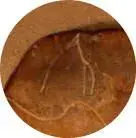
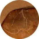
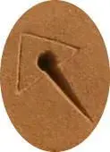
First is the gradient-depth, pointed line, which comes out of the hole in the middle of the triangle. It's odd, because it is the only marking on the maps, that has an intentionally varied depth. None of the other markings use depth as part of their meanings. So why does this one?

Needle.jpg


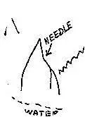
And the other, of course is the "Needle." This peak seems amazing to me, because of the reasons stated in post #12, above. It is unique because---

Needle.jpg Symbol of any dagger.

Dagger sm.jpg Symbol of any headstone.


Headstone sm.jpg Weavers Needle.jpg

Not just any peak!


So, why is this needle a very descriptive drawing, of a specific thing, when everything else is symbols and squiggles? Also notice that in both instances, each is located above water.


Both the gradient-depth line and the peak, break the rules of the rest of the Trail Map. Is it just coincidence, or are these two items supposed to be "keys" to the code?


:coffee2:
 

Attachments

  • Triangle-hole-line.jpg
    Triangle-hole-line.jpg
    4.1 KB · Views: 2,351
Re: The "Peralta" Stone Maps --- On Their Own

EE.:

There have been suggestions that the Triangle/Slash symbol represents Comet Peak (33.2939°N 111.269°W ).
I myself looked into the possibility that a comet,observed in 1847,might have inspired the use of such a symbol.
There was such a comet,discovered by astronomer Maria Mitchell.Also 23P/Brorsen-Metcalf .
Perhaps such a comet had been first reported at that position within a named star cluster or sign of the zodiac.A triangle perhaps?
Another maybe was the well known Halley's Comet,named posthumously and rightfully in honour of Edmund Halley,who correctly calculated it's return in Dec 1758.I also looked at whether or not the 1847 on the Stones,could have been a similar predictive calculation... if one were to combine the known period variability with one of the "formulas" inscribed on the stones.Could 1847-(76 to 79yrs) -/+ such a "formula" give a possible date for something related to the maps themselves?

Regards:SH.
 

Re: The "Peralta" Stone Maps --- On Their Own

Ok, my take on these puzzle codes,
The knife matches a same symbol on a rock face carveing,maybe a warning.
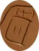
The so called head stone , is really a door,with a cross style marking on it.
The peak,is a right angle,,shoulder of the pyramid
The pointed deep needle type object is a stake marker I believe was put into the river bottom as a boat mooring, or on a mound of land to note the place of the pyramid and it is in front of the pyramid.
my takes.
 

Re: The "Peralta" Stone Maps --- On Their Own

While the "comet" ideas yielded some interesting leads,I eventually found something which I found to be of even greater interest.
Closer I think,to what I had been looking for.

The dagger,remember,has both what appears to be a "D" (or similar symbol) on the handle,as well as what appears to be a directional arrow as a hilt.These two additions imply this dagger's meaning to be much more than "any",IMO.
The dagger may be the single most important symbol to be considered when trying to understand the Stones.
A dagger is quite suitable as a tool for scratching directions in the dirt,or as a pointer as well.Probably the reason for it's inclusion on the stone.It is also more effective than a single edged knife as a weapon,offensive and defensive.It has an advantage,over a knife,of being able to cut both ways.In a sense a kind of "equivocator".

Regards:SH.
 

Re: The "Peralta" Stone Maps --- On Their Own

somehiker said:
The dagger,remember,has both what appears to be a "D" (or similar symbol) on the handle,as well as what appears to be a directional arrow as a hilt.These two additions imply this dagger's meaning to be much more than "any",IMO.

Regards:SH.


That's true. I was trying to distinguish between a symbol and an actual depiction of "The Needle," and I left out those special parts of the dagger symbolism.

Sometimes people say it's an "A," also, but all the other A's are pointed, while this letter is rounded, so it appears to be a "D."

Also, the "D" in "DEL," on the Horse Stone does have the same kind of "wings," which go past the vertical line, and they are also in the same proportion, with the longer one being at the top. This could be an indicator that the same person carved all three stones, contrary to other appearances which make it seem that a different person carved the Priest/Horse Stone.

Horse Stone D.jpgDagger D.jpg


On the dagger, there is also a down arrow coming from the middle of the blade, down onto the handle, plus a right arrow made with part of the hilt guard. The big question is, what does all that mean? Heh-heh.

Also note that the lines which I take to be rivers, appear on both the Trail Maps and the Horse Stone (which is the reverse of the Priest/Witch Stone). Yet there are two extra "circle within circle" symbols on the Priest Stone, between the two "rivers." One of these is far to the right of the area which appears to be depicted on the Trail Maps.
 

Re: The "Peralta" Stone Maps --- On Their Own

I originally thought of the dagger as a key of some sort, perhaps the D looking image is a slot that fits over a specially designed bolt that turns,or the dagger may be designed to spilt apart,and each section may be a key for another fitting. Shades of indiana jones.
 

Re: The "Peralta" Stone Maps --- On Their Own

OG,

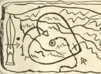
The point of the knife rests on Parker Pass. The arrow on the hilt takes you over Tim's Saddle and down into West Boulder. At that point, you pick up the trail that curves to the east, over a small saddle and directly to the heart in Little Boulder.

It's a puzzle that any child, without preconceived conclusions, could do easily.

The maps were created by people who knew the area well. That would preclude Travis, as you would need intimate knowledge of the legends, stories and terrain to put them all into your map. That knowledge would take many years of hands-on experience in the mountains.

Just one man's uninformed opinion. :icon_scratch:

Take care,

Joe
 

Re: The "Peralta" Stone Maps --- On Their Own

EE.:
Have a gander at the LIFE Magazine Photo of the Upper Trail Map.Enlarge it,so you can see the mark below the hilt of the dagger.
Then tell me what you think it is.It's different than the mark on the Stone at the SMM.There are other differences between the two stones as well,which could indicate the use of a duplicator to make copies of the stone maps.
see: http://www.copycarver.com/FAQ.htm .....you can make one yourself.
This kind of equipment has been in use for some time by makers of gravestones,signage,decorative stonework etc.
It is gradually being replaced by CNC abrasive/high pressure water equipment.

Regards:SH.
 

Re: The "Peralta" Stone Maps --- On Their Own

OL Goat:

I suspect that the authors of the IJ series,and other hollywood adventures,were influenced by a couple of centuries of prior treasure tales.
Innovative thought,however.

Regards:SH.
 

Re: The "Peralta" Stone Maps --- On Their Own

Somehiker---

I can't find the Life Magazine photo on the Net.

But I do know that many copies were made with molds. Something which resembled sandstone was poured into the molds, to make the copies look somewhat believable. Some are all one color, and some look like they were stained in various places, to look more natural.

Some appear to be copies of copies, because certain subtle marks and "scratches" are smooth on them. Like the heart under the writing on the Priest Stone in some photos looks like someone had tried to "erase" it, or whatever might have been there before.

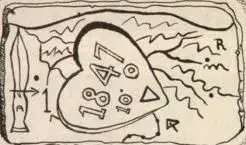
I found one drawing that eliminated the "Needle" from the Heart Stone. In its place, there is what looks like a mountain range. Also, the omega symbol is below a creek which isn't even on any of the pictures of the Heart Stone that I've seen. And the break in the heart lobe isn't shown, either, except on the side with the zeros on it (in another photo in the link below). An interesting fact is that the little hole or dent in the "river" line is included in this drawing, showing meticulous attention to detail. (?)

Early Heart Map.jpg


And with it was this one, without the Heart Stone, showing what could be a degree symbol after the 10 in the recessed heart area.

Early Trail Map without Heart Stone.jpg


They are from a magazine article by Bernice and Jack McGee, but it doesn't say which mag, or the date of it. There are also some other interesting photos with them, like the topo of the horse head.

You can see the whole thing on this eBay page. You have to click on "Description," and keep scrolling down to see all of the article and it's photos.

Added: I thought I had seen these drawings before, and I just re-found the site where they had been (and stlll are). they are on the Garry & Carol Cundiff Website, on this page, in a full-size copy of the original article from Frontier Times, dated April--May, 1973.
 

As an eBay Associate we earn from qualifying purchases.
Re: The "Peralta" Stone Maps --- On Their Own

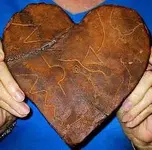
Another interesting factoid which appears in the test of the above 1973 article is, "Shaped like a huge valentine, the yellowish rock was hewn...from a slab of red chalcedony...."

While a caption under the drawings simply says---

Yellowish Rock Caption.jpg

Yellowish?

In all the photos that I have seen, it either just looks brown, or tan and reddish.

(The pictures of the Heart Stone appearing in my posts above, are lightened a bit to show the symbols better.)


Here is one from Cactus Jumper. It's the most colorful one I've seen (the rest just look brown). If someone asked me what color it was, I don't think I would say "yellowish"---

Stone Map closeup  heart sm.jpg


Is there another Heart Stone somewhere?
 

Re: The "Peralta" Stone Maps --- On Their Own

And gollum shows a comparison of different lower Trail Stone photos, on the "Tumlinson Stones..." thread, in this post.
 

Re: The "Peralta" Stone Maps --- On Their Own

EE.:

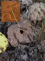
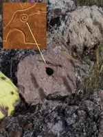
Some pics.
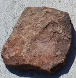
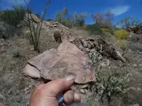
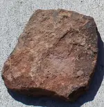
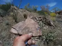
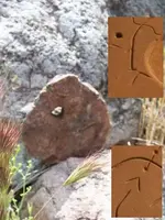
Stone from below a "shaped" collection of apparently man made constructs on a mountainside.
Another from a small pile of rocks on top of a big pile of rocks (in the shape of a heart) near the top of a canyon on another mountain.
Third and fourth on following post,are of two similar stones found,one at the beginning and one at the end of a trail that ends on a bluff overlooking the mound.The first has a "V' ,the second does not.

Regards:SH.
 

Attachments

  • 100_0576sm.jpg
    100_0576sm.jpg
    293.3 KB · Views: 1,742
  • 100_0568sm.jpg
    100_0568sm.jpg
    73.5 KB · Views: 1,701
  • 100_0576sm.jpg
    100_0576sm.jpg
    293.3 KB · Views: 1,685
  • 100_0568sm.jpg
    100_0568sm.jpg
    73.5 KB · Views: 1,675
Re: The "Peralta" Stone Maps --- On Their Own

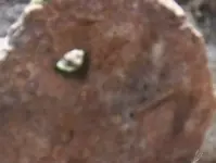
Three and four:

Both were found on isolated flat groupings of exposed rocks (not piled).
Posted in reverse order.
Stone with "V" was at beginning
Stone with hole only(closer to center of stone,though not exact) was at end.
 

Attachments

  • final marker.jpg
    final marker.jpg
    135.2 KB · Views: 1,685
  • heartstone marker.jpg
    heartstone marker.jpg
    61 KB · Views: 1,693
  • final marker.jpg
    final marker.jpg
    135.2 KB · Views: 1,579
Re: The "Peralta" Stone Maps --- On Their Own

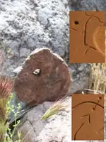
A better photo of the first stone.
 

Attachments

  • Marker 01.jpg
    Marker 01.jpg
    39.6 KB · Views: 1,790
  • Marker 01.jpg
    Marker 01.jpg
    39.6 KB · Views: 1,564
Re: The "Peralta" Stone Maps --- On Their Own

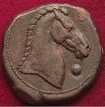
Somehiker, that horse head stone impression is very reminiscent;
horse-head-coin.jpg
 

Re: The "Peralta" Stone Maps --- On Their Own

That's interesting.Where did you find that?
If you're referring to the second photo,I don't see a horse.Or anything I would consider unnatural .

SH.
 

Re: The "Peralta" Stone Maps --- On Their Own

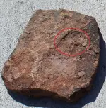
The horse head I saw on your photo I have encircled (had to borrow your photo to do this, hope that is OK) here it is:
100_0576smA.jpg
<hope this works>
Could be 100% natural, don't know. The coin photo is not my own coin, I do have one like this but not so nice.
Roy

:coffee2: :coffee: :coffee2:
 

Re: The "Peralta" Stone Maps --- On Their Own

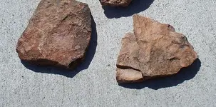
Here is a photo with both 1 and 2 together.I brought them both home with me,so I will have another look for anything on that stone.
 

Attachments

  • three stones.jpg
    three stones.jpg
    128 KB · Views: 1,602

Top Member Reactions

Users who are viewing this thread

Latest Discussions

Back
Top