The Knights Templar connection to Oak Island Challenge

As I said in the "Feudal Right and Odal wrong, A memorial to Orkney", SinClair was said to have been retracing his Ancestors foot step...So why not leave a marker of his ancestors (the Vikings).

Henry Sinclair? Well, for one thing there isn't enough time in his short life where his absence from Scotland would not have been noted before he was killed in Orkney by the English.

As William Thomson wrote:

It has been Earl Henry's singular fate to enjoy an ever-expanding posthumous reputation which has very little to do with anything he achieved in his lifetime.

And as far as the "Overton Stone" - to quote a nearby resident:

The reason I think its a hoax is that it is in a very popular sightseeing and picnic spot. The town nearby (Yarmouth) has been settled since the late 1700s. The entire area of Overton was cleared farmland not that long ago. Yet there seems to be no mention of it anywhere that I can find that is not very recent. I'f anyone can point me to a reference from an old book that mentions it I will gladly admit I'm wrong. I would like it to be old as it would be a mystery worth looking into.

The markings on the stone are very clear and there is no doubt about it being a carving. I have seen others in the past that were faint and you really had to use your imagination to figure out what they might be. For a carving of that quality in such a well traveled place and not get noticed? Seems extremely unlikely to me.
 

Last edited:
... SinClair was said to have been retracing his Ancestors foot step...
These quasi historians always seem to include a "Sinclair was said...".
According to them , Sinclair was said to have accomplished many many undocumented things. :laughing7:
PS "was said" is not definitive of "was proved". :thumbsup:
 

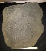
Now the "Boat Stone", A kids "Doodle"...It was unearthed while they were putting in a freeway in the 60's and some of our current roads in the US are based off old Indian paths. Why would you or anyone assume that the 184 was a date? Why couldn't it be a distance, with the arrow as a direction...With the ship representing "Coastal"...

Boat stone.jpg
 

T1822, what do these stones have to do with the Templars alleged Oak Island /Nova Scotia visit?
There is not even a miniscule circumstantial connection except for grasping at the strawman's straw.
 

Now the "Boat Stone", A kids "Doodle"...It was unearthed while they were putting in a freeway in the 60's and some of our current roads in the US are based off old Indian paths. Why would you or anyone assume that the 184 was a date? Why couldn't it be a distance, with the arrow as a direction...With the ship representing "Coastal"...

View attachment 1708445

What year did ships first have portholes? ;-)
 

Oh yes, I post "Speculative Theories" but that is the key "Theories" based on the stones carvings (Fact) and legends...
The only (Fact) concerning those stone carvings is their existence that cause legends and lore creation to explain their existence.
 

We'll never dissuade the faithful.

If they believe there is a direct, unbroken connection between King Solomon (who may in fact be a fictional character), the Knights Templar and the modern Freemasons then the force is too strong in their own convictions to step back and NOT see a connection in random rock chiseling. So of course "they" were on Oak Island, because they did everything else ever in history.

We have a local salt spring and the earliest date is 1813, I believe. And it seems to attract anyone with spare time and a chisel since then.
 

Last edited:
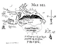
There is a connection and it has to do with the work Gilbert Hedden, a Oak Island owner. He base is views on a book written by a man named Harold Wilkinson in the late 1930's. The book contained a map which strangle enough resembled the perimeter of Oak Island. There was writing on the map and by using a surveyor by the name of Roper found man mad object. Hedden went to England to question Wilkins about the map and where he got the information. Wilkins at first stated he made it up but Hedden question even more because there were to many similarities between the directions and the survey. Wilkins then said he had seen it at the William kid museum in London. Hedden went there but found nothing, so he returned one more time to,question him but Wilkins final response was he couldn't remember where he seen it. Wilkins admitted that most of his research was by examining paper in the British museum. I believe Wilkins seen a map, i'm sure it's a vague map with nothing more the vague directions. He embellished it to sell a book fine but the information was obscured by one number...1 by 8 by "7". How do you "Retrace" a ancestors steps? You go "Backwards...When you follow in the footsteps you start at the beginning. The "Boat stone" is the starting point, how do we reference a map? north is up, now go backwards and move north opposite the arrow 184 leagues, follow the coastline as referenced by the boat. This bring you to Overton/Yardmouth. Second marker, Overton Stone. 3 to 4 days journey East by Northeast as the crow flies...Third Marker The norumbega vinland stone, a great deed somewhere on Mahone Bay...find the island that matches...

map.webp

go backwards, I believe Wilkins screw up and it should have been "1" by 8 by 4...find the "Tree" you know the on with the McGinnis boy found 14 rods south to the stone compass, 30 rods northeast . Two white granite stones with one hole in each were found were found during the survey. 18 rods east from the west stone and 7 rods west from the east stone. Welcome to the cave in pit.
 

Are you sure those are port hole? I would say they were openings for the sea water to drain out during rough seas.
 

Last edited:
The only (Fact) concerning those stone carvings is their existence that cause legends and lore creation to explain their existence.

And your saying kids did it...that are fully versed in lore and legend...really...
 

There is a connection and it has to do with the work Gilbert Hedden, a Oak Island owner.
He base is views on a book written by a man named Harold Wilkinson in the late 1930's. The book contained a map which strangle enough resembled the perimeter of Oak Island.
There was writing on the map and by using a surveyor by the name of Roper found man mad object.
Hedden went to England to question Wilkins about the map and where he got the information. Wilkins at first stated he made it up but Hedden question even more because there were to many similarities between the directions and the survey... i'm sure it's a vague map with nothing more the vague directions...find the island that matches...

View attachment 1708461

.

Is it Harold Wilkinson or Wilkins?
Was this 1930's book a work of fiction?
Was Oak Island mentioned in this book, because it it not named as such on this map?
I am sure one can easily find several islands in the Atlantic, Pacific, Indian oceans and the Caribbean that resemble the island depicted on this map.
Once again, a forced fitted fact in support of a pet theory lacking real provenance beyond one's imagination.
 

We'll never dissuade the faithful.

If they believe there is a direct, unbroken connection between King Solomon (who may in fact be a fictional character), the Knights Templar and the modern Freemasons then the force is too strong in their own convictions to step back and NOT see a connection in random rock chiseling. So of course "they" were on Oak Island, because they did everything else ever in history.

We have a local salt spring and the earliest date is 1813, I believe. And it seems to attract anyone with spare time and a chisel since then.

Show me the random artist...Find me the person who had seen the boulders free of carvings? Show me the documented events that make those area's a hot spot for activity. Random? I think not
 

Wilkins, yes he did write fiction, but what did he base it on? There are almost 300 islands in Mahone Bay and as I said a limited detailed map, he added to it for the book. The directions do not lead anywhere else so why would bring that up. There is no force, I believe it flow's quite nicely.
 

Wilkins, yes he did write fiction, but what did he base it on? There are almost 300 islands in Mahone Bay and as I said a limited detailed map, he added to it for the book. The directions do not lead anywhere else so why would bring that up. There is no force, I believe it flow's quite nicely.

Harold T Wilkins is characterized as a "pseudohistorian" and known for plagiarizing the works of others in his books on pirate treasure, Atlantis and Mu, secret ancient cities in South America, and hostile UFO's.
No one accepts any of his books as real history.
I understand now why you don't list the sources of what you post.
 

Then you seen who did it!

Well we know Harold T Wilkins didn't see who did it and most likely did created that map, or, true to his nature, maybe "borrowed it".
You need to discover better believable source material, but thank you for providing examples that support my position. :icon_thumright:
 

I never said it was, but he plagiarized that map which he probably seen in the London Museum. Your not paying attention
 

Last edited:
This map is known as "Desert Island Map #2" drawn by Harold T Wilkins as one of 4 of his WILKINS-KIDD pirate treasure maps, and has nothing to do with Mahone Bay, Oak Island, Nova Scotia or the Templars, but all to do about Captain Kidd.
Captain Kidd Treasure Maps: The Reality
Trust Me, Treasure1822, I am paying attention.
Why would you post this map as proof of the Templars in Nova Scotia?

As I mentioned on another post, you are in dire need of finding credible source material than plagiarizing fictional writers who create "treasure maps".
 

Last edited:

Top Member Reactions

Users who are viewing this thread

Back
Top