You are using an out of date browser. It may not display this or other websites correctly.
You should upgrade or use an alternative browser.
You should upgrade or use an alternative browser.
Raise your hand if you have found the Lost Dutchman Mine.
Azquester
Bronze Member
- Joined
- Dec 15, 2006
- Messages
- 1,736
- Reaction score
- 2,600
- Golden Thread
- 0
- Primary Interest:
- All Treasure Hunting
I deny finding this rock near the LDM.
Nice map rock good "A" map on it! I found one similar setting on another boulder at the end of a horrific canyon of scrub brush. Where ever you found it look around the surrounding area for the symbols in sunlight or shadow. It has a reverse "F" for final and an "A" for go to or "At" the spot. Good "A' Maps are more permanent in bed rock and not usually carved but made up of natural quartz seams on a huge slab of stone that passes for bedrock. "A" Maps get smaller as you go closer but only as a permanent placement. Portable "A" Map rocks were just teasers along the trails. Practicing carved guide stones to be more precise. A smaller version of a larger project nearby. Good find!
Azquester
Bronze Member
- Joined
- Dec 15, 2006
- Messages
- 1,736
- Reaction score
- 2,600
- Golden Thread
- 0
- Primary Interest:
- All Treasure Hunting
I deny finding this rock near the LDM.
I deny you found that rock by the LDM! Why?
Because I did!!
View attachment 1337047
torie517
Sr. Member
- Joined
- Jul 11, 2015
- Messages
- 318
- Reaction score
- 232
- Golden Thread
- 0
- Location
- big heart mountain
- Detector(s) used
- Do not
- Primary Interest:
- All Treasure Hunting
nice rocks the mountain has lots of them
torie517
Sr. Member
- Joined
- Jul 11, 2015
- Messages
- 318
- Reaction score
- 232
- Golden Thread
- 0
- Location
- big heart mountain
- Detector(s) used
- Do not
- Primary Interest:
- All Treasure Hunting
this is what I am going to do the snakes are bad this year they are even in town so October we will start up the mountain get videos and prove my point people are telling me hedge canon but there is a crop of weed there in front of the mine and water tank so i will let who ever planted the stuff get it and go .
markmar
Silver Member
- Joined
- Oct 17, 2012
- Messages
- 4,299
- Reaction score
- 6,529
- Golden Thread
- 0
- Primary Interest:
- All Treasure Hunting
this is what I am going to do the snakes are bad this year they are even in town so October we will start up the mountain get videos and prove my point people are telling me hedge canon but there is a crop of weed there in front of the mine and water tank so i will let who ever planted the stuff get it and go .
I believe how they will not get it and go , but they will deposit the stuff in that old mine . Better to stay away from that mine . You were enough lucky to left the place alive .
markmar
Silver Member
- Joined
- Oct 17, 2012
- Messages
- 4,299
- Reaction score
- 6,529
- Golden Thread
- 0
- Primary Interest:
- All Treasure Hunting
Joe
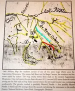
You have posted a map from T E Glover book which shows the Military trail in the west part of the Superstitions . I want to explain my opinion about this map .
I believe the La Barge Canyon is not that Mr. Glover wrote on the map but the blue line . The map has a bad topography and we have to take in consideration the most logical orientation in comparison with the todays topo .
Also the Needle Canyon is the red line . If you look at the red line you will see how go south to Weavers Needle .
My opinion is how the Military trail on the route (2) , follow the Dutchman trail untill join the junction of Bull Pass trail , follow the Bull pass trail untill join again the Dutcman trail , follow the Dutcman trail to the south until join the Terrapin trail , and continue to the south on Terrapin trail untill reach the Weavers Needle .

Last edited:
cactusjumper
Gold Member
Joe
You Have posted a map from T E Glover book which shows the Military trail in the west part of the Superstitions . I want to explain my opinion about this map .
I believe the La Barge Canyon is not that Mr. Glover wrote on the map but the blue line . The map has a bad topography and we have to take in consideration the most logical orientation in comparison with the todays topo .
Also the Needle Canyon is the red line . If you look at the red line you will see how go south to Weavers Needle .
My opinion is how the Military trail on the route (2) , follow the Dutchman trail untill join the junction of Bull Pass trail , follow the Bull pass trail untill join again the Dutcman trail , follow the Dutcman trail to the south until join the Terrapin trail , and continue to the south on Terrapin trail untill reach the Weavers Needle .
View attachment 1342747
Marius,
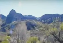
I am convinced that Dr. Glover's copy and reading of the 1866 Military Map is correct. I have found part of the old trail in the mountains. Here is a picture of it:

This trail is exactly where it should be in relation to the military map. It is worn into the bedrock.
Good luck,
Joe
markmar
Silver Member
- Joined
- Oct 17, 2012
- Messages
- 4,299
- Reaction score
- 6,529
- Golden Thread
- 0
- Primary Interest:
- All Treasure Hunting
Joe
I would say to be not convinced absolutely . The Superstitions are full with worn into the bedrock trails .
But , at last , you could be right , and the top of the Little Boulder canyon to be the end of the stone trail and the end of the Military trail .
hooch
Banned
this is what I am going to do the snakes are bad this year they are even in town so October we will start up the mountain get videos and prove my point people are telling me hedge canon but there is a crop of weed there in front of the mine and water tank so i will let who ever planted the stuff get it and go .
get some gaiters at REI for $30 bucks, snakes never stopped any of us
cactusjumper
Gold Member
Joe
I would say to be not convinced absolutely . The Superstitions are full with worn into the bedrock trails .
But , at last , you could be right , and the top of the Little Boulder canyon to be the end of the stone trail and the end of the Military trail .
Marius,
You are mistaken. The Military Trail continues west through Little Boulder Canyon through a saddle, drops down into West Boulder, turns north past Yellow Peak and continues north to the Salt River before turning west and eventually ends up at Fort McDowell.
The map is really pretty simple and not that hard to figure out.
Good luck,
Joe
torie517
Sr. Member
- Joined
- Jul 11, 2015
- Messages
- 318
- Reaction score
- 232
- Golden Thread
- 0
- Location
- big heart mountain
- Detector(s) used
- Do not
- Primary Interest:
- All Treasure Hunting
snakes cover most of the ground here this time of year October is soon to be here and I need the rest...the green snakes are the most trouble and the smugglers are also bad this year .I would like to live to spend my gold money . and as I have said I am not at the superstition near phx.. I am at the other superstition the right superstition...the mountains near phx is were the thunder god lives .here is were the trickery lives the superstition mountain I asked a 90 year old relative thats what she said her grandmother was from the superstitions she said how could you live with the thunder god .living with trickery is easy you just do not talk about it or say its name .
torie517
Sr. Member
- Joined
- Jul 11, 2015
- Messages
- 318
- Reaction score
- 232
- Golden Thread
- 0
- Location
- big heart mountain
- Detector(s) used
- Do not
- Primary Interest:
- All Treasure Hunting
and as for hedge canyon I go were I like weed or no weed ..
torie517
Sr. Member
- Joined
- Jul 11, 2015
- Messages
- 318
- Reaction score
- 232
- Golden Thread
- 0
- Location
- big heart mountain
- Detector(s) used
- Do not
- Primary Interest:
- All Treasure Hunting
if I follow you all.... I would be lost.
nobodie
Hero Member
- #378
Thread Owner
I read somewhere that if someone finds a treasure, the government takes half of it. What is considered treasure to the government? I'm sure that gold bar's, gold coins, jewelry anything made of precious metals is treasure, but is a cache of bags of gold nuggets considered a treasure?
deducer
Bronze Member
I read somewhere that if someone finds a treasure, the government takes half of it. What is considered treasure to the government? I'm sure that gold bar's, gold coins, jewelry anything made of precious metals is treasure, but is a cache of bags of gold nuggets considered a treasure?
They will take whatever they want, laws be damned. We are seeing that very clearly with what is happening in North Dakota with the pipeline.
Dirt1955
Full Member
- Joined
- Mar 10, 2015
- Messages
- 190
- Reaction score
- 366
- Golden Thread
- 0
- Location
- Orange County, CA
- Primary Interest:
- All Treasure Hunting
Nobodie. If you find treasure keep if to yourself and off the web. The Feds will come after you for their share anytime any place. Just send us wink and "how'd you do" and we'll get the message.
Similar threads
- Replies
- 54
- Views
- 3K
Users who are viewing this thread
Total: 1 (members: 0, guests: 1)


