How Deep...Is This?
It has always been puzzling why there were
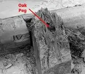
"Roman Numerals" carved on the
"Wooden Beams" found in Smith's Cove.

It was always puzzling why the
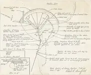
"Builders" would choose the Horseshoe design for the
"So Called Coffer Dam" shown to be located there.

Unlike the North End of the Island, Smith's Cove is a very shallow rocky inlet.
The
"U Shape Dam" and the location within a shallow bay would not have been the
"Logical Choice" if intended for some sort of
"Docking Location".
It would have been more practical to have built a
"A Straight Dam" and at the farthest outreach on the Island.
But!...This was not the intent of the
"Builders"!
What they were working on was a protection for erosion from the High Tides associated with this end of the Island.
The Coffer Dam was not a Dam...But...
A Breaker!
In the Mid-18th Century the ocean level was very much lower than it is today.
Marine Survey Canada shows that the sea shore would have been out past what we show as the Coffer Dam.
The Wooden Beams with the Roman Numerals carved on them jut out past this Coffer Dam to show what the Sea Level marked in Roman Numerals was at this time.
The Coffer Dam was constructed to be a
"Tide Breaker" preventing the erosion of the beach soil drifting back out and plunging up the
"Tunnels Blow Holes!
Within the Sea Shore and this Protector Breaker was placed Rocks, Eel Grass, and Coir Fiber to stop any erosion.
My Theory has the Cornish Miners (who built the tunnels to flood the Oak Island Money Pit) running their Main Tunnel below the 90 foot level straight out past the Coffer Dam to where one sees the Blow Holes located.

At this point (roughly 200 feet from the present shore line today) they branched several tunnels up to nearly 10 feet under the ocean.
Explosive Powder Charges were placed at the end of each of the branched tunnels with a fuse running back towards the Money Pit.
"To ignite the end of each tunnel, they fed an ignition "sausage" out of each tunnel. This sausage was a tube made of linen and filled with granulated black powder that led back to the point of ignition. The ignition sausage, a predecessor of the modern time fuse, was normally laid in a 6-centimeter-wide wooden duct and covered with a board to protect it from moisture or other damage. At the appointed time, the miner ignited the powder in the ignition sausage with an ignition sponge and then retreated quickly before the sponge burned to the powder."
Once the fuse was lit and about to discharge the Miners began to seal the 10 foot distance from the Water Tunnel to the 90 Foot level with Logs, Clay, Dirt, Coir Fiber, and Tar.
The Explosions opened each tunnel to the Ocean's water, but the air lock in the main tunnel prevented the water from coming and flooding the Money Pit Shaft, until this air lock was broken in 1795 by the Original Discoverers.
Similar to how today's toilets function.

The 18th Century British used Roman Numerals to mark the ocean depth on the Bows of their Ships!

These are the same Markers on the Wood of these Beams!
We should be able to determine (with the help of Canada's Marine Ocean Records) what the Ocean Level was at each marking to verify when the Oak Island Money Pit Was Constructed!


 from the investors. Sure they may have lied some to get more investor money but it wasn't used to live the high life. The Restalls lived a hard life on the island for the years they were there. No road to the island, had to boat over to main land for everything... No electricity on the island. Yeah your right fun life to have just to milk investor out of money. NOT!!!!


