MYSTERY ROCK

Sodabob

Sr. Member
Jan 14, 2019
273
191
Primary Interest:
All Treasure Hunting
Howdy

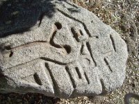
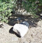
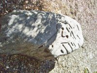
I haven't been around for a while and had to re-register with a different name. Anyway, I'm working on a real mystery and could use some help. If I can remember how to post pictures, please notice the carved images in what locals call "The Mystery Rock." I have been asked by our local Historical Society / Museum to research it, and depending on the results here, might write an article for them in their newsletter. The rock has already been examined by a group of Archaeologist but they are baffled as to what the carvings might be or represent. The only thing they determined with any certainty is that the carvings were done with some type of steel tool such as a chisel. As for the date it was carved, they are baffled about that as well. Its located in a brushy area about 100 feet away from an old State highway and about 100 yards from an old Railroad line that was built in 1916. In the area there is also an old U.S. military encampment that was built in 1940-41 and sold to the County around 1947-48. The two most prominent theories are ...

1. The rock was carved by a Railroad worker
2. The rock was carved by a member of the Military

But regardless of who carved it or when, we are trying to determine what the carvings might be or represent? The archaeologist said they don't recognize the pattern and are pretty sure they are not Aztec or anything like that, and that they might be random that only the "carver" knows the meaning of.

If you have any theories or recognize the pattern as something specific, please let me know and I will pass the information on to the Historical Society. The rock is located about 50 miles east of San Diego along old Highway 94.

Thanks in advance to those who participate in possibly solving a mystery that has had locals baffled for several years.

Sodabob ... a.k.a. Sodabottlebob and Sodapopbob


The rock is about 6 feet long, 3 feet wide, and about 2 feet thick. Most of the carving are on one end of the rock but in some places continue over the side. The local museum has permits to move it next Spring but will need a backhoe to lift and transport it.
100_5380.JPG

100_5377.JPG

100_5378.JPG
 

Last edited:
Upvote 0
Last and probably Least, this is where my buddy Donal Hord might have stayed if he visited the area and carved the Mystery Rock. The Hotel burned down around 1940 and was located within walking distance of the Mystery Rock.

By the way, the main reason I'm considering Donal Hord as the possible carver is because the more I study the rock the more convinced I am that it took a trained, artistic hand to achieve it. I'm having serious doubts it was carved by some yahoo out for a leisurely jaunt in the countryside. ???

Campo Hotel 1910.jpg

Campo Hotel Mountain Inn 1915.jpg
 

Upvote 0
The “Y” looks like a depiction of the females reproductive track to me. Dunno.
 

Upvote 0
Symbols (2).jpg
In an effort to pop some more detail out of the picture, I ran it through my photo editing program. The "Y" is a prominent feature, but the rest of it has no rhyme or reason. Looks like it might be a map for something possibly, but more than likely it looks like practice possibly.
 

Upvote 0
In my opinion, rock appears granitic. The carvings show the same patina and rules out recent. I would suggest a geological study on the granite type and depth of oxidization to get a better idea of the "era" it was carved in. Personally it reminds me of Nordic Runes but is also to geometric for that and could serve as a map. Great emphasis was put into carving the y with ball ends, it's carved very deep. I don't see someone doing this by hand for giggles. Take a chisel and hammer to the other end and you'll see what I mean. I bet oxidization layers would show it's pre-native like pumapunku............ Good luck!
 

Upvote 0
RAL

Thanks for the Suggestions and Observations. I have already suggested to the Museum people to have the rock thoroughly tested and they are considering it. I guess it depends on their budget, etc. But agree it might help.

I have already done some experimenting with a cold chisel on "similar" granite rocks but don't want to try that with the actual rock because it would deface it. The experiments I did were not very promising because a cold chisel is too soft for hard granite. But at some point intend to purchase a "Carbide" chisel and see how that goes. I already have one in mind that's priced at about $25.00 and is the least expensive one I could find.

I looked at a bunch of Pumapunku carvings and symbols. Please post some pics of the ones you think are similar to those on the Mystery Rock.
 

Upvote 0
Here's what I call the "kitchen sink" because just about everything else has been considered and I'm running out of options. I admit its a little far fetched, but what isn't about this topic? Like I have said previously, the first thing that came to mind when I first saw the Mystery Rock was that it looked Aztec and/or Mayan. Probably the most prominent of anything that's Aztec/Mayan related is the Aztec Sun Stone Calendar. While I was researching the sun stone I came across a reference that claimed it resembled the Aztec capital city known as Tenochtitlan. So I took a look and sure enough, they do kind of look similar. But what really caught my eye was the Y shaped avenue that ran through the center of the ancient city. Which in turn made me wonder if the carving on the Mystery Rock was a map of some sort? I acknowledge that a map has already been suggested, but I'm just expounding on that. Anyhoo, compare the following attachments to each other and see if you can pick something out that I missed. And if you are into the Aztec Sun Stone, you gotta check out this video. It has some of the best imagery and information about the stone that you will likely find anywhere. Its about six minutes long. Be sure and watch it in the full screen format.

https://www.ancient.eu/Sun_Stone/


[ Original Sun Stone ~ About 12 feet wide and 3 feet thick ]

Aztec Sun Stone Calendar.jpg


[ Artist rendering in color ]

Aztec Sun Stone Calendar Colar.jpg


[ Drawing of the Aztec capital Tenochtitlan from a 1524 Spanish document ~ Notice the Y shaped avenue ]

Aztec Capital Tenochtitlan 1524 (1).jpg

[ Mystery Rock ]

Mystery Rock (15).jpg
 

Last edited:
Upvote 0
About the best I can find off the cuff. I'll do a bit of research later. Maybe turn something over! :)

images.jpeg

pumapunku-side-view.jpg

puma-punku-archeology-site-bolivia-aidan-moran.jpg

It's the only type of stone work I can think of that's similar with geomtry. I honestly think it's a map. But then again there could be more rocks buried nearby. But you can clearly see similar geometric shapes between the site and the mystery rock. When I look to the top of the y, I see a rectangle inset into it. Geometry coinciding to balls on y channel. Though looked at different, channels only. It resembles Nordic Runes a bit. All I can think of, there's nothing I've seen that rings an instant bell of where it belongs in classification. I'd just start another El Dorado myth honestly, that is if my career depended on some sort of sales. Who knows, maybe it could be! But I'm no archeologist, just an enthusiast of ancient lore and mathematics.
 

Last edited:
Upvote 0
Just take this into perspective though for dating. At one point the surface was rubbed smooth. They flattened it out. There's a lot of erosion showing.

I guess I could interpret the y as horse face or whatever. But then there's geometry. Guess I'm gonna have to find a rough location for the stone on topographical maps and start there. I think if it's a map then there'd be something sticking out pretty quickly.
 

Upvote 0
P.S.

I just got off the phone with the museum curator, who is in charge of the project to eventually move the rock to the museum, and he said the general consensus among the archaeologist and everyone else who has studied the rock are in agreement that the carving was done approximately 100 years ago. Apparently they dated it based on how long it typically takes for a natural patina to develop and obscure any evidence of recent carving. And because the 100 year date correlates to when the rail line was built in 1916, they strongly suspect there is a connection. The best guess theory they came up with is that whoever carved the rock had some knowledge of geometric patterns and/or the type of knowledge that a railroad surveyor might possess. Plus, the immediate area around the rock is like a hollow and would be a great place to pitch a tent and camp. But the real mystery isn't WHO might have carved it but whether there is a message to be discovered in the carvings, and if so, what that message / meaning might be? If anything? Apparently no one has been able to identify the pattern and/or symbols yet.

I'm not buying it. After a hard day of laying rail, I go back to my tent and chisel on a 6' Boulder for fun. These people have never obviously had to do real work.
 

Upvote 0
I'm not buying it. After a hard day of laying rail, I go back to my tent and chisel on a 6' Boulder for fun. These people have never obviously had to do real work.

Imagine that you are the cook. Equipment and tools piled all about. Keeping the beans warm and hanging around camp.
 

Upvote 0
Imagine that you are the cook. Equipment and tools piled all about. Keeping the beans warm and hanging around camp.

Washing laundry and constantly catering to the workers needs. There was no leaisure time on the railways then or now.

There's better odds it was done by Spanish conquistadors lol

Not saying it wouldn't have made a nice piece of wonderment in a railway camp though! I'm sure it would of been a great past time to study it after work.

Let's just pretend it's somebody bored. They would of been camped there probably about 6 months to a year to put a smooth face on it and carve it. Even with primitive techniques of what is locally available like live oak to produce lye to possibly soften the rock. It's a serious undertaking. The coral castle wasn't built for giggles. Nothing that takes that amount of time is done for giggles.

I'm just gonna believe it's a map of something. Maybe the canyons, maybe Spanish mines and was carved by captured natives as a map so other conquistadors couldn't read it, maybe it's a Aztec or mayan map for trade routes along a road that never went out of use as tons of ancient roads are still used today. If I had to put an educated guess on it after looking at it many times, it screams map. It shows a complex of structures, glyphs for mountains and water. I bet closer examination would show more, but I'd theorize it's a map of some sort. An important map with purpose. It might even be a map of a north American complex headed north that's went undiscovered. Many of the sites in South America we're built on top of pre-native structures. The natives say it was there when they got there. You can see the different stone work. But scholars will lie to keep lining their pockets. Can't be wrong ya know. But I'm pretty positive it's older than 100 years just by looking at the surface erosion and iron in the channels could of gotten there by a later group grinding materials in it. I mean it could easily become a tool if you needed it to be. All we can do is speculate until something clicks.
 

Last edited:
Upvote 0
Let's just pretend it's somebody bored. They would of been camped there probably about 6 months to a year to put a smooth face on it and carve it. Even with primitive techniques of what is locally available like live oak to produce lye to possibly soften the rock. It's a serious undertaking. The coral castle wasn't built for giggles. Nothing that takes that amount of time is done for giggles.

For a minute there, I thought you said 6 months ... you meant 2 days, right ? Lol.

Air Hammer.gif

Air Chisel.jpg

Air Chisel 3.jpg
 

Upvote 0
So finally pulled up Google maps on topographical. Here's what I found.

Screenshot_20190218-231029.png

Reverse image... Almost matches stone... Water glyph at top... Triangular rises in landscape, etc... I'd take a look at older topographical maps of the area.

Personally I think it marks pre-native sites and not mines. Basic poke and prod excavation would tell you by checking out geometric locations. But from what I can tell, it's harsh terrain. Hence road maps on rock. The big y channel could refer to water sources, i.e. Wells. Driving 2000 miles to help identify markings by terrain sounds fun, but I can't afford that journey. I'm not 100% on it but from the looks on the topo map the triangle marks we're terrace's or gardens. I'd say it was the map of a complex for trade purposes. Telling where your business there was conducted as it's a pretty large swath of land and rough terrain. But I'm betting that each individual marking carried out specific tasks and that there's more stones near each site from trail approach. I'd also not use horses as pre-native sites give off frequencies that can spook them. Use a atv and feet if exploring is done. You can also do simple tests for frequencies cheaply, reference that I know of for checking frequencies in pre-native is Michael Tellinger.
 

Last edited:
Upvote 0
I can't help but notice that this rock is, for lack of a better word, "anti-art" .
Work such as Hord's has curves ... higher carving is curved everywhere.
Different tools, different approaches, and a much higher "mind" is required to carve a statue.

This ? ... this is straight lines and a few circles.
Good for maps ... good for symbols ... absolutely good for POWER TOOLS.

If you want quick and simple, you use a circular blade, or grinding wheel, or power chisel ... whatever.
It is far simpler to cut out designs quickly with power tools if you lay it all out with straight lines.
And circles ? ... no problem ... drills spin and grinders spin ... circles are easy.

From many angles, including this, I'm leaning towards this being WW I era or later, rail road being one possibility, but, I also get a 1929 - 1939 vibe ... possibly associated with the Dust Bowl.
These roads would have been a steady stream of unemployed people packing the tools of their trade and looking for anything.
There'd be stone workers included. Miners, engineers, quarrymen.

And what would you have along the way ? ... every damb business along the way is stone related.
Every gas station, market, hotel, motel, gift shop, camp ground for a hundred miles would be decorated with rocks, selling rocks, ... hauling rocks to the road side for walls and statues and oddities ...tourists galore.
This would balloon into the Route 66 style, but I'm thinking of the abundance of workers heading west during the dust bowl and how anyone able to work with stone seeing this whole area as a possibility to find work.

This wasn't done by a kid with a pocket knife, hammer and screwdriver trying to impress his girl.
This was done by someone who had the tools, had previous experience with those tools and knew how to layout a design that would be quick and not too demanding on his tools.
I think those tools were power tools.
 

Upvote 0
From a political and historical aspect I would play off the RR story to media as deterrent to the public. Leave the rock there with game finder's for surveillance. Then further explore the region until it can be determined if it's a complex of historical significance. That pretty much ends any input I have into this subject. I hope it was helpful.
 

Upvote 0
I can't help but notice that this rock is, for lack of a better word, "anti-art" .
Work such as Hord's has curves ... higher carving is curved everywhere.
Different tools, different approaches, and a much higher "mind" is required to carve a statue.

This ? ... this is straight lines and a few circles.
Good for maps ... good for symbols ... absolutely good for POWER TOOLS.

If you want quick and simple, you use a circular blade, or grinding wheel, or power chisel ... whatever.
It is far simpler to cut out designs quickly with power tools if you lay it all out with straight lines.
And circles ? ... no problem ... drills spin and grinders spin ... circles are easy.

From many angles, including this, I'm leaning towards this being WW I era or later, rail road being one possibility, but, I also get a 1929 - 1939 vibe ... possibly associated with the Dust Bowl.
These roads would have been a steady stream of unemployed people packing the tools of their trade and looking for anything.
There'd be stone workers included. Miners, engineers, quarrymen.

And what would you have along the way ? ... every damb business along the way is stone related.
Every gas station, market, hotel, motel, gift shop, camp ground for a hundred miles would be decorated with rocks, selling rocks, ... hauling rocks to the road side for walls and statues and oddities ...tourists galore.
This would balloon into the Route 66 style, but I'm thinking of the abundance of workers heading west during the dust bowl and how anyone able to work with stone seeing this whole area as a possibility to find work.

This wasn't done by a kid with a pocket knife, hammer and screwdriver trying to impress his girl.
This was done by someone who had the tools, had previous experience with those tools and knew how to layout a design that would be quick and not too demanding on his tools.
I think those tools were power tools.

It's not impossible that a steam generator was dragged out there and used to carve it. But you say tools could have done it quickly. Just to get the smooth face they would of needed a quarry saw for blocks and boulders. It would be a rare item to be dragged across the terrain. Then to not fracture out the grooves it would of required one of two methods. Either grinding or saw cuts on either side of the groove to chisel out center. Both of which with tools would of still took a lengthy amount of time. Literally months...... I've worked with rocks for over 20 years and I most certainly couldn't do it in a couple days with diamond tools. It would take me at least 4 months to do. Provided I wasn't constantly collecting fuel for my steam generator. That's the perspective I see. We're talking a hard rock with indistinct cleavage planes.

Even if we loaded it and took it to a saw for facing it. 4 days... Then setup a 3d auto CAD printer... Another 5 days due to constantly changing bits plus setup and tear down. Then haul the rock back... I mean really take that into perspective.... Not considered granite fractures randomly under heat cause of quartz content. Really think about it.
 

Last edited:
Upvote 0
Thanks to everyone concerned for all of the recent observations, comments, and suggestions. Every little bit helps. (Pun intended) I might add that one clue often leads to others and that all possibilities are still being considered. Speaking of clues, notice that the Y and and at least two of the rectangles, and possibly one of the triangles, are the only carved out areas that will capture standing water and not allow it to drain out. Also notice that whoever did it intentionally carved some of the grooves over the side of the rock, which would allow any water to spill over the side. This standing water observation might explain the orange/rust colored patina inside the Y

Mystery Rock (3).jpg

Mystery Rock (15).jpg
 

Last edited:
Upvote 0

Top Member Reactions

Users who are viewing this thread

Latest Discussions

Back
Top