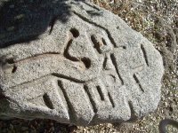
MYSTERY ROCK

Sodabob

Sr. Member
Jan 14, 2019
273
191
Primary Interest:
All Treasure Hunting
Howdy

I haven't been around for a while and had to re-register with a different name. Anyway, I'm working on a real mystery and could use some help. If I can remember how to post pictures, please notice the carved images in what locals call "The Mystery Rock." I have been asked by our local Historical Society / Museum to research it, and depending on the results here, might write an article for them in their newsletter. The rock has already been examined by a group of Archaeologist but they are baffled as to what the carvings might be or represent. The only thing they determined with any certainty is that the carvings were done with some type of steel tool such as a chisel. As for the date it was carved, they are baffled about that as well. Its located in a brushy area about 100 feet away from an old State highway and about 100 yards from an old Railroad line that was built in 1916. In the area there is also an old U.S. military encampment that was built in 1940-41 and sold to the County around 1947-48. The two most prominent theories are ...

1. The rock was carved by a Railroad worker
2. The rock was carved by a member of the Military

But regardless of who carved it or when, we are trying to determine what the carvings might be or represent? The archaeologist said they don't recognize the pattern and are pretty sure they are not Aztec or anything like that, and that they might be random that only the "carver" knows the meaning of.

If you have any theories or recognize the pattern as something specific, please let me know and I will pass the information on to the Historical Society. The rock is located about 50 miles east of San Diego along old Highway 94.

Thanks in advance to those who participate in possibly solving a mystery that has had locals baffled for several years.

Sodabob ... a.k.a. Sodabottlebob and Sodapopbob


The rock is about 6 feet long, 3 feet wide, and about 2 feet thick. Most of the carving are on one end of the rock but in some places continue over the side. The local museum has permits to move it next Spring but will need a backhoe to lift and transport it.
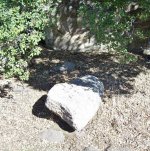
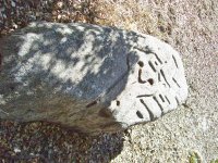
100_5380.JPG

100_5377.JPG

100_5378.JPG
 

Last edited:
P.S.

I'm curious about but can't explain why the Y symbol is the only carved out area on the rock that has the rust colored patina, whereas the other areas don't. ???
 

Upvote 0
I went ahead and did some photo magic on my phone for you. First I screen shot the topographical maps of the area. Then I adjusted the image of the rock by exposing to negative to heighten the patterns contrast. I did several adjustments to the rock image to get optimum effects with a transparent layer. No drawing. I aligned both to maps and rocks true north. This is what I saw. To me it further proves it's a geoglyph or map.

1550600582450.png

Adjusted rock photo

1550599740940.png

Though as you can clearly see I just aligned the circles on the y with water sources. It magically aligns to most of the topography. Complete coincidence with both facing true north? I did play with the overlay and found it fits the topography in several directions but not like it does true north. I don't think it's symbols at all. Just a geoglyph showing the flat hexagonal terrain in which a complex probably existed.

Also the image of the rock is taken from an angle. So maybe if the image was taken straight down, it would perfectly align to the topography.
 

Last edited:
Upvote 0

sailaway

Very interesting and a possibility. Even though it hasn't been fully addressed yet, the railroad line that was completed in the area in 1915 used Chinese laborers. I'm searching now for documentation to support that claim and will post them if/when I find any. I may have to go to our local railroad museum to find anything but they are only open on the weekends and will have to wait until then.
 

Upvote 0
I went ahead and did some photo magic on my phone for you. First I screen shot the topographical maps of the area. Then I adjusted the image of the rock by exposing to negative to heighten the patterns contrast. I did several adjustments to the rock image to get optimum effects with a transparent layer. No drawing. I aligned both to maps and rocks true north. This is what I saw. To me it further proves it's a geoglyph or map.

View attachment 1682587

Adjusted rock photo

View attachment 1682588

Though as you can clearly see I just aligned the circles on the y with water sources. It magically aligns to most of the topography. Complete coincidence with both facing true north? I did play with the overlay and found it fits the topography in several directions but not like it does true north. I don't think it's symbols at all. Just a geoglyph showing the flat hexagonal terrain in which a complex probably existed.

Also the image of the rock is taken from an angle. So maybe if the image was taken straight down, it would perfectly align to the topography.


RAL

Thanks for the forensic examination. Very interesting. I will take a closer look at the terrain and landmarks the next time I go to the Mystery Rock, which will likely be this coming weekend, especially if I go to the railroad museum. That way I can kill two birds with one stone (Pun intended)
 

Upvote 0
California railroad builders were badass stone workers with a proven history.
If this was associated with a railroad crew, it would of been an extremely minor feat to pull off.

Just making this up, but, as they cut through the hills following the rails, why not make sure a big rock was laid in the camp as a table while they were there.
Perhaps there is a trail of flat rocks oddly laid in convenient camping spots every 5 miles or so ? You could follow their tracks.

Tunnel Crew.jpg

Tunnel2.jpg

Tunnel3.jpg

Tunnel5.jpg

Tunnel6.jpg
 

Upvote 0
Thanks for posting so much on this , I think this rock is really interesting. If you go back there could you get close up pictures of the triangle and squares cut into it , I am just wondering if they are cut at basically 90 degree angles or if they slope inward , also the more reddish brown patina on the "y" might be from water settling in there with dirt and other dust debris. One thing also it looks like the circles on the "y" ends look rounded or cupped , seems like it would have to be done with something round and not a square type instrument on those.
You have put out many interesting theories to ponder , I cant say I would subscribe to any of them at this point but intriguing . I agree with Rocksalot that whoever made them knew what they were doing and had to have spent some time making them, also the map theory sounds like a possibility . I think bored railroad workers would be lower on my list of possible makers but who knows. I have searched a few area that had railroad camps around similar time periods and they didnt leave much and I also dont think they had much time for activities like that , but they did have access to tools so there is that...
Please keep us posted
 

Upvote 0
P.S.

I'm curious about but can't explain why the Y symbol is the only carved out area on the rock that has the rust colored patina, whereas the other areas don't. ???

Being a larger surface area than other indentations and the fact it was meant to show water sources pretty much explains it. Other reasons being a rail spike was rubbed in the groove or other metal tools to sharpen them. Plus there's the possibility of minerals just under the surface reacting to rain. I could list way to many reasons.
 

Upvote 0
Another idea ?

Nov. 2017 this place just up the road goes up for sale. 90 acres ... $ 1.25 million
Ben Schultz, a San Diegan was, and may still be the owner.

This site was bought back in 1918 by a former mayor of San Diego, Bert Vaughn.
320 acres which he developed into the town of Jacumba.

A few years later, 1922, he started to build a stone tower.
Some make the logical claim that he built the tower as an attraction to his town, especially the bar.
His son claims he was bored and wanted something to do.
He finishes it in 1928.

Along comes the depression, and an unemployed engineer shows up. (there's very little info. , but this is what pieces together)
Merle Ratcliff (one site has it as W. T. Ratcliffe) ? ... was an engineer, and he knows how to cut rock.
He hangs around and Vaughn puts him to work carving the stones adjacent to his tower.

He works cheap ... all accounts claim he got paid $1 a day and a jug of wine.
He's happy, hangs out for two years and carves "dozens" of large stones.
The modern site said there are 40 large carvings there today and he had carved most of them.

24 months/dozens of carvings ... We're looking at roughly 1, or closer yet, 1 1/2 carvings a month.

Maybe he had something to do with this rock ? Who knows, there's thousands of untold possibilities out there.

I think it might be worth checking the place out. It may still be a museum, may still be owned by Ben Shultz.
They might have pictures or knowledge of other things Ratcliffe carved.
Also, there was a mention that one of the carvings was done by the Native Indians.
That might be a good opportunity to compare directly, depression era style / technique vs. one of native influence.
You would have the two, side by side to ponder.

Ratcliffe3.jpg
 

Last edited:
Upvote 0
Food for thought ...


Chinese Symbols for Man and Woman
(Also used for Person/People/Mankind)

Chinese Symbols for Man and Woman.jpg


Chinese Symbol for Prisoner
(Y Shape Inside a Square)

Chinese Symbols For Prisoner.jpg


Mystery Rock (11).jpg
 

Last edited:
Upvote 0
PNP

Your last post is of "The Desert View Tower" which I have been to dozens of times, including a school field trip when I was in the 3rd grade. My brother in law's mother used to operate a cafe near there in the early 1950s where he grew up for a time until they moved into Jacumba. The cafe was demolished in the 1970s when they built the freeway through the area. I considered it as a possible connection early on but wanted to go out there first before commenting about it. The Tower is still open and is a fee tourist attraction. The area near the Tower where the stone carvings are located is called "Boulder Park." The first opportunity I get I plan to go out there and see if there is anything to connect it with the Mystery Rock.

Mystery Rock Boulder Park Dog Sculpter.jpg

Mystery Rock Boulder Park.jpg
 

Upvote 0
NEWS FLASH!

I heard yesterday (via the grapevine/gossip) that an individual has come forward who claims to have known about the Mystery Rock for "at least 40 years." The person I heard this from did not know the individual's name or anything else about them, but I will be looking into it for confirmation. The museum people are aware of the rumor? but don't know any more about it than I do - which isn't much.
 

Upvote 0
Just in case anyone is wondering ...

English to Chinese translation for H Lem Toy

Mystery Rock H Lem Toy Translation.JPG
 

Upvote 0
Just for the Record ...

Here are a couple of the pics that member sailaway posted links to the other day. Compare them to the design on the Mystery Rock ...

Mystery Rock Chinese Carved Rock.jpg

Mystery Rock (15).jpg

Mystery Rock Chinese Carvings.jpg
 

Upvote 0
Last but not least (For the time being) ...

The attached snippet is from a magazine called "The San Diego Reader" which is a weekly publication that I usually read. This particular issue is from 2003. I spoke with the museum curator and he confirmed 100% that Chinese laborers were definitely involved with the construction of the San Diego & Arizona Railroad (SD&AR). We also have a Railroad museum that's different than our regular museum, and I intend to visit it soon and see what's what regarding the Chinese laborers.

Link to magazine article ...

https://www.sandiegoreader.com/news/2003/apr/24/140-mile-mistake-railroad-museums-living-history-p/


Mystery Rock Chinese Railroad Connection SD Reader Magazine 2003.JPG
 

Upvote 0
PNP
"Boulder Park." The first opportunity I get I plan to go out there and see if there is anything to connect it with the Mystery Rock.

Boulder Park, yes. Thank you. I hope the rock they mentioned as being carved by natives is there. I'd really (really really) appreciate seeing close-ups of that one. It's possible they were simply hired as Ratcliffe was, handed the same tools and put to work. But, I'd expect their approach would be entirely different.

If I remember, it was a fertility wheel ? ... or something along those lines, that was mentioned.

There's two questions that I have concerning the layout of your stone.

When you are there, what are the feelings you get as to how the approaches from both the road or the railroad may have looked back in the day ?

Is it flat, such they would have no problem driving to this camp ?
Or, would they have to wind a road around rocks and trees to get there ?
Any signs of old road berms, or old tractor work ... any trees now growing in and hiding an old roadway ?
That sort of thing.

Second, what is your general feeling about were the rock lies.

Does it feel obvious ... "OH, look, it broke off there and it fell and rolled and now lies here" ?
Or is it more a mystery how it got to lie in this spot ?
I could picture a terrain where most of the large rocks are laying naturally ... but someone selected a nice, flat one and moved it into the center of camp.
But, I'm also curious if it may have been worked on at some other spot and brought to the center of camp.
Related to the ingress/egress idea ... I can picture a carver such as Ratcliffe, or anyone, wanting a base for a carving. Perhaps something as simple as, "I'm always carving yellow rocks, it would be great to go a few miles down the road and get a whiteish one for the base. What I'd do is take tools to the whiteish rocks and test them. Perhaps start a few nondescript lines that could be carried on later, creating a designed base for my carving that didn't detract from the focal point of the carving set on it. If I was working along those lines, I'd purposely make the design nondescript, taking special care that it couldn't be confused with the local native designs. You know what I mean ? You don't want people to look at your carved giraffe and become confused because of a native style base. You want people to admire the giraffe, so you make a base that isn't going to draw any attention.

At the same time, if the rock proved too hard and difficult to work, I might not waste any more time, and simply leave it as a future possibility. Moving up and down the road looking for another possibility.
At Boulder Park, are the carvings all in-site rocks, but things like the stairs, benches, tables, all look out of place ? Did they have round rocks aplenty but had to search elsewhere for the nice flat ones ?
Reading about that tower, I have to believe they were well equipped to travel around and pick up and haul large rocks back.

OK, sorry, long winded ... but I just thought of a third question. Ratcliffe was a drinker ... standard practice for remote drinkers is "let's go to the bar". Jacumba had a bar ... but what about that hotel you showed ... was there enough attraction in Campo, bar wise, that one might semi-regularly make the trip from Jacumba. ?
If I was a carver and a drinker ... I'd know every turnout along the way, I'd know the rocks available at each and every turnout, I'd know where I could hang and sleep one off. Would this camp make a good spot to spend the night after the bars closed ?
 

Upvote 0
PNP

I won't be able to answer all of you questions at the moment, but will do my best with some of them by answering them in RED on your post.


Boulder Park, yes. Thank you. I hope the rock they mentioned as being carved by natives is there. I'd really (really really) appreciate seeing close-ups of that one. It's possible they were simply hired as Ratcliffe was, handed the same tools and put to work. But, I'd expect their approach would be entirely different. I'll check one of these days when it warms up a bit - snow predicted for tomorrow

If I remember, it was a fertility wheel ? ... or something along those lines, that was mentioned.

There's two questions that I have concerning the layout of your stone.

When you are there, what are the feelings you get as to how the approaches from both the road or the railroad may have looked back in the day ?

Is it flat, such they would have no problem driving to this camp ?
Or, would they have to wind a road around rocks and trees to get there ?
Any signs of old road berms, or old tractor work ... any trees now growing in and hiding an old roadway ?
That sort of thing. The rock is near the old highway and easy to get to. The Railroad tracks are nearby as well. There is no evidence of a road directly leading to the rock but if some brush was cleared away it could be driven to by a 4x4 etc. There are a jillion large rocks in the area but none that would eliminate access to the rock if some brush was taken out.

Second, what is your general feeling about were the rock lies.

Does it feel obvious ... "OH, look, it broke off there and it fell and rolled and now lies here" ?
Or is it more a mystery how it got to lie in this spot ? Immediately behind the rock is a hill composed almost entirely of solid granite. I believe the rock came from that hill but was likely from natural causes. The next time I'm down there I'm going to try and determine exactly where it fit like a puzzle piece - but might be difficult to determine because I believe it was the underside of the rock that connected to the hill and I don't know what the underside is like (yet)
I could picture a terrain where most of the large rocks are laying naturally ... but someone selected a nice, flat one and moved it into the center of camp.
But, I'm also curious if it may have been worked on at some other spot and brought to the center of camp. Because the rock is about 6 feet long and 3 feet thick, I highly doubt it was transported there. It must weigh a ton or more.
Related to the ingress/egress idea ... I can picture a carver such as Ratcliffe, or anyone, wanting a base for a carving. Perhaps something as simple as, "I'm always carving yellow rocks, it would be great to go a few miles down the road and get a whiteish one for the base. What I'd do is take tools to the whiteish rocks and test them. Perhaps start a few nondescript lines that could be carried on later, creating a designed base for my carving that didn't detract from the focal point of the carving set on it. If I was working along those lines, I'd purposely make the design nondescript, taking special care that it couldn't be confused with the local native designs. You know what I mean ? You don't want people to look at your carved giraffe and become confused because of a native style base. You want people to admire the giraffe, so you make a base that isn't going to draw any attention. ?

At the same time, if the rock proved too hard and difficult to work, I might not waste any more time, and simply leave it as a future possibility. Moving up and down the road looking for another possibility.
At Boulder Park, are the carvings all in-site rocks, but things like the stairs, benches, tables, all look out of place ? Did they have round rocks aplenty but had to search elsewhere for the nice flat ones ? ?
Reading about that tower, I have to believe they were well equipped to travel around and pick up and haul large rocks back. No way! The entire area immediately drops off into the desert and is like a jungle of massive rocks like the ones in Boulder Park. Pull up some images of "Mountain Springs Grade" and you will see what I mean.

OK, sorry, long winded ... but I just thought of a third question. Ratcliffe was a drinker ... standard practice for remote drinkers is "let's go to the bar". Jacumba had a bar ... but what about that hotel you showed ... was there enough attraction in Campo, bar wise, that one might semi-regularly make the trip from Jacumba. ?
If I was a carver and a drinker ... I'd know every turnout along the way, I'd know the rocks available at each and every turnout, I'd know where I could hang and sleep one off. Would this camp make a good spot to spend the night after the bars closed ? There are and were bars in that part of the county but doubt that someone like Radcliffe would need to go to that particular spot to "sleep one off." There are a jillion places just like it between Jacumba and Campo that could be used for the same purpose
 

Last edited:
Upvote 0
P.S.

As much as I'd like to disclose the exact location of the rock, I will wait and do that later because the rock has been getting a lot of attention lately from locals who have heard about it through the grapevine and want to see it for themselves. We feel the less people that know about the location the better the odds are that it won't be defaced or that any digging will be done until a team can be put together to do a proper excavation with sifting screens, etc. I have Google Earth images and a lot of other pictures that I will be sure and share at the proper time.
 

Upvote 0

Top Member Reactions

Users who are viewing this thread

Latest Discussions

Back
Top