Red_desert
Gold Member
- Feb 21, 2008
- 6,986
- 3,616
- Detector(s) used
- Garrett Ace 250/GTA 1,000; Fisher Gold Bug-2; Gemini-3; Unique Design L-Rods
- Primary Interest:
- All Treasure Hunting
It has been years ago, it got named the Tonge Nugget.
Follow along with the video below to see how to install our site as a web app on your home screen.
Note: This feature may not be available in some browsers.
oh yeah! i’ve read about the tongue nugget. i think that was around 2001It has been years ago, it got named the Tonge Nugget.
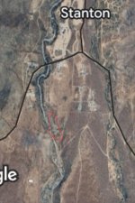
The 2nd map is a close up of my claim. You can also see the patented “Lucky Johnnie & Katie” claim just West of my 120 acres. That guy has a mineshaft that produces well and supposedly goes under the northern part of my claimGot some action 1st map between Stanton Cemetary and Stanton. Multiple places on 2nd (might be I checked more on it).
Here’s the official map or plat from Yavapai County that shows the patented claims, I’ve circled the general area of my 120 acre unpatented claimThe 2nd map is a close up of my claim. You can also see the patented “Lucky Johnnie & Katie” claim just West of my 120 acres. That guy has a mineshaft that produces well and supposedly goes under the northern part of my claim
Wow Red, holy cow! I’m going to cross reference your hits with a topo map and geological report and see what matches up with what’s already been discovered and/or drilled. This is a great start and if something comes of it through sampling and testing, we can work it out. I’ll be sure to compensate you.I got tired of marking spots 2nd map, so had to stop. Probably will need to zoom in more for the important places.
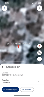
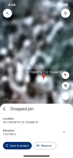
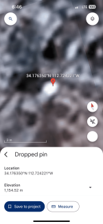
View attachment 2159399
Any idea if the hits you marked yellow on the map are gold ore veins or nuggets or any other mineral? The claim was tied up for over 40 years without any development or production. It was just used as a piece of land for LDMA club members to go metal detecting on. I know there is a Tungsten occurrence on the claim that was documented and dug on but not worked extensively.On a quick check, picked up either a shaft or digging west of yellow bottom area, east near top.
Yeah that’s still relatively pretty far away from my claim. I don’t have access to any land on the alluvial delta south of stanton or weaver/octaveThe last time I was there, heading past Stanton towards the Hassayampa I stopped and dowsed down toward Antelope creek, using Gold, I signaled 1 strong target down in the creek. Someone was drywashing near my target, so I planned to return, but haven't made it yet. I marked in red, where I dowsed it. The area is large boulders, I assume I signaled a boulder, rather than an ore vein. I didn't turn and dowse towards rich hill..
not yet at least…Yeah that’s still relatively pretty far away from my claim. I don’t have access to any land on the alluvial delta south of stanton or weaver/octave
Any idea if the hits you marked yellow on the map are gold ore veins or nuggets or any other mineral? The claim was tied up for over 40 years without any development or production. It was just used as a piece of land for LDMA club members to go metal detecting on. I know there is a Tungsten occurrence on the claim that was documented and dug on but not worked extensively.On a quick check, picked up either a shaft or digging west of yellow bottom area, east near top.
not yet at least…
that’s about to change as of tonight 😈
The 2nd map is a close up of my claim. You can also see the patented “Lucky Johnnie & Katie” claim just West of my 120 acres. That guy has a mineshaft that produces well and supposedly goes under the northern part of my claim