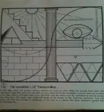
Lue Map

Attachments

  • hiter 33.jpg
    hiter 33.jpg
    1.3 MB · Views: 334
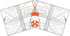
That is rather fascinating RW. I try not to stretch too far, but I have noticed a few interesting things. I can't help but wonder how you came up with that...trial and error?Keep in mind, I have a copy of the map over my computer in my office...means I spend quite a few hours a week staring at it or at least glancing up. Now and again something jumps out at me and I wonder how I never noticed it before. One thing I noticed a few months back (keep in mind the map has been staring at me for at lest three years) was that some random lines line up with the lower triangles as such:

LUE KvM THM7-Connected Lines.jpg

Not sure what it means, if anything, but I certainly thought it a wonder that after three years I could still notice new things about something I'd been looking at for nearly ever. I hung it on the off chance that is a Mason came into my office they might be able to offer insight. So far I've had several, but none have had much to say about the map. Not sure if that's being secret, or simply not knowing. Either way the outcome is the same. It's easy to assume that the map might be Masonic, or make the connection from Masons to the KGC. But as Nobody pointed out, the Templars, pirates, Masons, KGC and probably a dozen other organizations utilize a lot of the same symbols. One could make an argument for them all being as a "lineage" of sorts, and some have tried. For my part is still comes back to how do the symbols fit into the map to tell a cohesive story?

Keep in mind also, a lot of people are focusing on CO and NM as a location for the LUE...a casual reading of some of KvM's NPG articles offer another additional solution that I've never heard anyone talk about. Point being, a lot of people have worked one area and if the reports are true, many were successful. Whether much remains to be found South of Segundo remains to be seen but there may very well be a pristine avenue of investigation as well.

Randy
 

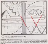
I believe I've posted this before - however, I think it is worth repeating.

This is a page from Treasure of the Valley of Secrets (Segundo, Colorado: 1971). It's a rare item (I'm asking about $250 for the one copy I'm willing to part this at this time).

Anyway - because it is so scarce I'd like to share this sign. I think it has a remarkable similarity to the LUE Map.

View attachment 851499

Good luck to all,

~The Old Bookaroo

This is digging Waaaaaay back but I think it requires some consideration. KvM published these sketches in the Treasure of the Valley of Secrets. The comparisons to the LUE map are readily apparent, particularly the top sketching. For me this is a fascinating development, but an equally troubling one. Fascinating because this has the potential to be some groundbreaking evidence. Troubling because as it stands it's not very good evidence. Photos would have given the symbols an improved level of credibility. As they stand they are a hand drawn representation of information provided by KvM and sustained by KvM. Like the LUE, the evidence rises or falls on KvM's reputation. These symbols for me give rise to a number of questions...
*Assuming they are genuine, are they still there? Many LUE hunters allegedly destroyed symbols and monuments to prevent others from finding caches.
*Were these the only ones associated with (in all likelihood) the LUE or are there more to be found, or more that have been found that simply aren't associated with the LUE.
*Were these meant to be used WITH the LUE map or as a way of locating treasure in the absence of the map (I prefer to think the later).

It's also worth noting, that Larry Goddard who as listed as having found one of those symbol sets was also reported to have been someone who found a LUE cache in a letter to KvM by a third party (though, admittedly, published by KvM).

It's an interesting addition to the LUE stockpile of data for sure...
 

Well, that tomcat has the right idea, and his suggestion was clear to me but in the end, I usually do my own thing on my own time. I got white deer showing up on treasure legend sites, at least one bear every year saying hi and telling me to wake the hell up and get goin' (I've been within 6-7' of a bear before while out in the woods), half a dozen mtn lion.

And 3-4 wolves, who were all headed south. I share all that mostly to get in the wolves part. There are outdoorsy people here that would be interested to know wolves have been in Coloroado for years now. Seen more than one at 11,500'-13,000' in winter on a major north/south land bridge. Any doubters can find at least report of a radio collared female from Yellowstone being hit by a car on I-70 near Dumont the better part of a decade ago. Might need to dig, but it was in the local rag. I saw more than one that found a better way across I-70, as have others. Had a Lynx that had a little more imporant message for me, though ...

And I consider this just tying up some 'LUE-se ends'. I don't have a bunch more to contribute on a public forum with this, so it shan't be long for those who find my input here irritating to no longer be irritated. I've probably mentioned this all in other posts, as well. All ya'll should try to get Patrick out of the woodwork after I'm gone, too. He doesn't care for me much, I don't think. He's not alone there, lol. But he has hunted the LUE and his dad hunted the LUE and had some field contact with KvM. Pretty sure he has also written about the LUE (article). He will tell you that the rays from the sun upper left indicate individual cache spots, the pillars in the center are man made objects to locate, the Rio Grande Pyramid is involved, the sine wave are rivers, that knowing what the YAMAY-WHATEVER key is important, that north is to the right etc. Claims to have located the last unopened cache site on private property (northern NM instead of CO, I think?).

He is also poking around Blanca Peak, looking for something, like me, and my guess is he can't find what he is looking for. Maybe he'd say it is unrelated ...

I'm not saying it related or not, but this cairn on the western side of Culebra has always piqued my interest. It is probably 10'+ tall. Culebra Peak is still on private property and was part of the Maxwell Land Grant:


View attachment 1134335

Let me fill in a bit about the three grave site I referenced. It is north of the Urraca Pioneer cemetery and on private land. I talked to the land owner (since 80's) about it. The Colorado Historical Society fenced it off and cleaned it up a bit at one point, and family members came of one the people there out from Kansas (pretty sure KS) not too long ago and put new grave stones on all three. All three were purported to have died from wood alcohol poisoning, in one take. There was a mining camp right there, and one guy strikes a vein (silver, IIRC). In celebration, he goes to the nearest town, Mosca, and orders up a bottle "Good alcohol". What he was given, instead, was a bottle of Wood alcohol. By the time the party was over back at the mining camp, three were dead from wood alcohol poisoning and were buried close buy.

I mentioned a Templar link. That does not just mean 1300's dude walking around with a sword. Whether a direct connection or not, there are Secret Societies that still, today, use Templar symbolism - like the Skull & Bones. That was a key part of the story - they all drank the wood alcohol even though there was a Skull & Bones on the bottle. Supposedly they had dropped some candy in it (as people apparently did that with bad whiskey back then) and couldn't tell what they were drinking.

I have this all written down and would need to check details on all of this, including the name Grandpa Nelson. Pretty sure that was it. It was G-Pa's grave where there is some question regarding whether it is him or his grand daughter buried there. There are also ties in this story that go over to the Bonaza gold area just to the west of the upper end of the SLV by Poncha Pass. You have Round Hill in the SLV and then Round Mountain in the gold region. There is confusion in some stories you read on whether Hill or Mtn, but the Round Hill/Mtn are linked as a stash point for the Treasure Mtn Legend of southern CO that was a French/French-Canadian job.

But maybe there is nothing to all of that other than the public domain story.

The original owners of the Maxwell Land Grant were Guadalupe Miranda, a secretary to the Gov. in Santa Fe, and Carlos Beaubin, French-Canadian trapper turned Mexican citizen, granted to them in 1841. Lucien Bonaparte Maxwell married Beaubin's daughter, which is how he ended up with is name on it.

Too much coffee - let me go visit the loo, since I am talking about French things like San Luis, aunt Urraca, Beaubins, guys named Bonaparte, Templars, Secret Societies (Paris is a hotbed and has been for quite some time) etc.

You mentioned Jesuits, formed in France, as well, Randy. As far as their mathematical/astronomical knowledge, while you have specialists within the Jesuits, in general, they are highly educated and very intelligent men, and always have been. Many Jesuits are more accurately referred to as Father Doctor So-and-so. I spent 8 years at a Jesuit school. Everyone just called him Father Lawless (that was his real name - too funny for a Jesuit), even though he also had at least one PhD. Concerning things astronomical, in addition to being quite interested in demonology, the Jesuits are the Vatican astronomers.

Like, literally the astronomers foe the Vatican. Right now, as I type this, the Jesuits operate a telescope on Indian Holy Ground atop Mt. Graham in Arizona. The name of that telescope?

Lucifer.

That ain't a damn joke. That is for real. Verify it for yourself:

Lucifer Instrument Helps Astronomers See Through Darkness to Most Distant Observable Objects | Popular Science

There were a lot of words I typed in a conversation with Rog a couple months ago that I do not think are around anymore. I know there will be some of you, if even a small amount, that read those words. Feel free to think some of my conclusions are wrong, but hold off on the thinking I am bat crap crazy. Everything - from the Chronology to the Evil Aztec Priests (some of which I did not and will not share on a forum like this) with their enchanted caves and enslaved Indian miners, to Suleiman and Hiram Abifiratti, to what guys like Rog and Willie are seeing with their aliens, etc. Keep in mind we are talking about the Culebra Peak and range - the Snake/Serpent peak and range, an influence out of Europe. Quetzlcoatl was Caeser-coatl ...

Rog, btw, is who claims to have authored the LUE as a 5 or 6 year old child using remote viewing when CIA agents came to his home in southern Cali and made him ...

We'll see how many more of the things I said that are no longer around end up filtering into other people's own stuff ...

All of which (those words of mine) are tied to SEVERAL of these Treasure Legends. The Jesuits, IMO, were way less interested in looking for gold. They had other things to find or track down and destroy/suppress, in addition to whatever gold they were after for whatever reason and use. and they had interest in the area, whether LUE specific interest or not.

And with that, I think that is about it for me. Probably. I do enjoy chatting about the LUE, and good LUE conversation is hard to come by ... Definitely


In regards to the telescope who said Jesuits do not have a sense of humor. love the irony in the name.:laughing7:

Crow:thumbsup:
 

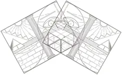
Going off of the theory that the shaded side of the pyramid on the left points north, I rotated each side until the shade was vertical and then lined them up at the center. The horizontal lines/column became downward steps and the best part for me is that the 2 tiny little pyramids appear as ladders going even deeper. Not sure if the symbol created in the nose area means anything (thunderbird?). Another area of the map that I have dwelt upon is how the vertical and horizontal columns cross, solid thick line, solid thin line, broken thin line... this area becomes the ear area of the most realistic head shape angle.
 

Attachments

  • lue steps 2.jpg
    lue steps 2.jpg
    1.3 MB · Views: 384
Last edited:
Right now, as I type this, the Jesuits operate a telescope on Indian Holy Ground atop Mt. Graham in Arizona. The name of that telescope? Lucifer. That ain't a damn joke. That is for real.

Lucifer - Waiting for Nibiru Since 1993

Keep in mind we are talking about the Culebra Peak and range - the Snake/Serpent peak and range, an influence out of Europe. Quetzlcoatl was Caeser-coatl ...

Culebra = snake

And with that, I think that is about it for me. [strike]Probably. I do enjoy chatting about the LUE, and good LUE conversation is hard to come by ...[/strike] Definitely

Yeah, sure. Ha ha. Stick around, it's good to think about new ideas - the old ones are a bit threadbare.
 

Hi Nobody,

Thanks for the response.

Yes, I probably have some original KVM materials and items that never made print or public visibility. Most of which is in the form of hand written letters and notes.

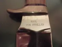
Here is a cool knife that is part of the collection:
IMG610.jpg


Anyway, watching the thought processes regarding the LUE map. There are some really creative and analytical minds at work here. My compliments.

Might one suggest that perhaps we run the risk of overthinking to fill in segments we do not know. It is like trying to solve an algebra equation when elements are missing and we are trying to solve for 'X'. In this case, X marks the spot, right?

The LUE map is a reference point. As is the reference to TVOS, #7, Spanish Trail of Gold, etc. We have a collection of reference points to a mysterious and little known treasure. But, even having a stack of additional reference materials are like concentric circles (rings inside of rings). While the creativity and analysis challenge us to fill in the missing blanks, it also runs the risk of shoving us in the wrong direction, by degree or by league. Stop overthinking.

If one lacks the skill to use a sextant, the map is unbreakable as far as pinpointing a physical location. People lacking this skill are using fringe or home made methodologies to resolve the missing skill. But, be your own litmus test on the result. Can the modified map lead you to a physical location? If not, it is probably leading you astray while becoming part of the LUE lore. If it helps, start the triangulation with polaris. I might recommend asking probing questions when alternate or fringe LUE hypotheses are presented, such as, does the person submitting the result analysis have the skill of celestial navigation using a sextant? If not, how does the idea, submitted from the Treasure Hunter Theorist, pinpoint physical locations?

My recommendation is simple. Take all of your LUE reference materials, treasure articles, maps, books, ideologies, etc. Put it in a big pile and shove it aside then go back to the drawing board. Use what you do know as the exit point in a maze and retroactively trace the maze to the beginning. Simply put, We all know the geography and associated timelines. (although some fringe theories contradict historical fact.) Use the geography and timeline as your starting point then research and profile who could have been the originators and logic for the treasure caches that we refer to. Then, go do field research.

Also, keep in mind that LUE is an acronym for the three hand written words on the original map. A better starting point for paying attention to submitted ideas will be when a historical timeline of factual events coincide with the altered map theories. I know for a fact that this information has been compiled by at least three individuals. (And, no, I am not talking about materials created by treasure hunters no matter how famous they are/were.)

I also saw a comment about the templar connection. It did raise an eyebrow when the carved rocks on the cache site I found included the Spanish Cross (looks like an iron cross) and a templar shield. Anyone knowing treasure symbols know that these two symbols are a political sticking point since it represents a claim of ownership both for the crown of Spain and the Templar. I have uploaded these pictures before.

Anyway, great reading. Keep up the great work!

Patrick
 

Last edited:
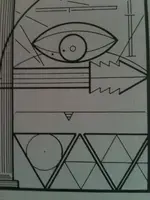
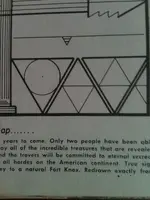
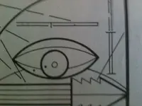
Hi. I am glad to see this discussion about the LUE. Like everyone else, I have tried to gather what little info I could find. After reading through the thread, I would like to share a few thoughts and welcome the discussion that will follow. I started out yesterday, by getting out my copies of the # 7 manuels and the TOTV0S. A few years ago, I had noticed that the LUE maps are slightly different in manual # 7 in a copy I have. I had a discussion with Old Bookoroo, and he told me my copy was a fake. He even offered to buy it, but I choose to hold on to it. You can read this thread, here on tnet. If I can get my old scanner up and running, I will post a copy of the map for members here. There is only the addition of three dots, two of which are located in what looks like the all seeing eye. The third is in the pyramid with the circle below it. I also noticed that what appears in the bottom left of the map was the partial golden spiral, when I compared it to a picture I had found on a website about different types of signs. If you rotate the map 180 degrees it will become apparent even though the entire spiral is not shown on the map. That made me realize that maybe this is 4 maps in one. That each quadrant, if you will, represents possibly physical signs found in the field.
Now today, I ran across a story about a step cave with an underground river @ hardscrabble peak. If you rotate the map, the steps go down on the pyramid in the first quadrant. Also the heavy lines in the middle could possibly represent the underground river. There is another story I remember around Kanab, Utah about steps going down related to Aztec treasures. Now, the reason I am thinking this is because here in La. I have been chasing KGC signs and trail trees. In the TOTVOS, there is a squiggle line with a snake head going to the right. Here I have been reading this as a travel on symbol with the head or circle as the direction of travel. I had a discussion with Old Dog here on Tnet once about this. In my opinion, he is one of the best trackers here and knows what he is talking about. I suggest reading everything he has to say about signs and tracking. The other signs in TOTVOS appear to me to be spanish or KGC, and I would welcome a tracker like Old Dog's opinion regarding them. When I looked at the map upside down, I started seeing other signs that I never noticed before. One example, is what is seen as the sun in the 1st quadrant. With the map flipped, it begins to look like a traditional all seeing eye or possible half circle of a buried treasure symbol.
I was suprised to see the suggestion that KVM was in the KGC or had info related to them that he was revealing to the public. However, after thinking about it, this makes alot of sense. We already know that many of the big treasure stories started coming out in the 20's and 30's. Sometimes with no back story that can be verified, just like the LUE. I have tried before to locate the book "Spanish trail of gold" with no luck. I did a quick internet search and found several people seaching in the past for the book, but never located it. Maybe the clue here is the "Spanish Trail" and there is no book to be found. I personally would be willing to spend several hundred dollars for a real copy of this book. If nothing else, it would prove that it does exist. I am a big KVM fan and have tried to acquire at least one copy of anything and everything he has written. I am still working on that very small collection that I have managed to acquire through the years.
I have other ideas that I will share when I have more time. I can't tell you why KVM spent 20 years off and on, refering back to this map. I do think, it had great value in his mind or he would have not gone to the trouble he did to put it out there and try to get discussion going about what it truely was.
 

Hi. I am glad to see this discussion about the LUE. Like everyone else, I have tried to gather what little info I could find. After reading through the thread, I would like to share a few thoughts and welcome the discussion that will follow. I started out yesterday, by getting out my copies of the # 7 manuels and the TOTV0S. A few years ago, I had noticed that the LUE maps are slightly different in manual # 7 in a copy I have. I had a discussion with Old Bookoroo, and he told me my copy was a fake. He even offered to buy it, but I choose to hold on to it. You can read this thread, here on tnet. If I can get my old scanner up and running, I will post a copy of the map for members here. There is only the addition of three dots, two of which are located in what looks like the all seeing eye. The third is in the pyramid with the circle below it.

There are at least three relatively common versions of the LUE map that I know of. I for one would be happy to see you post the one you're referring to.

*KvM first published the map in 1966 though many people do not realize there is a version of the THM #7 printed this early as the widest release was from the RAM versions that came out in the early 1970s and again in the late 1970s.

*Thomas Hilton reprinted the LUE in his 1970 True Treasure article which is perhaps the most ever written on the mp (though he is critical of the story and attempts to debunk the LUE). Hilton's map contains two changes over the KvM original that I cn easily spot. One is a dot in the circle in the bottom right corner, another is a small dot in the tip of the triangle to the immediate right of the circle I just described. Hilton never mentions KvM by name in his 4700 word article, nor does his indicate where his version of the map came from. My sense is that he made the two dots as minor changes to avoid copyright issues and leave himself vulnerable to a lawsuit. Unfortunately, many researchers have presumed his article to be the earliest reference to the map. They clearly were not tracking ealier printings of the THM #7 or previous mentions of the LUE in the less accessible (but no less earlier) National Prospector's Gazette (among other references).

*The third version I've seen commonly, though only on the Internet, is the annotated which contains symbols in the outer margin of the map and some minor changes within the map as well. Interstingly, this map has the same two dots I just described in the Hilton version. This map has been shared much earlier in this thread, but bares mentioning. I first heard of this version in a post on the old Treasurenet forums. For my part it looks fake, the additions to the map in no way are consistent with the quality of the map itself and this is readily evident.

point hunter, I'll touch on your response more later, lunch calls. Enjoyed your feedback and hope to hear more from you!

Randy
 

Hi. I have taken some pics with my cell phone. They are not perfect, but they do show the changes I am refering to. This map is in the 'so called' copy of TH # 7 copyright 1966.
 

Attachments

  • 4.jpg
    4.jpg
    422.3 KB · Views: 281
  • 2.jpg
    2.jpg
    416.4 KB · Views: 202
  • 3.jpg
    3.jpg
    421 KB · Views: 224
  • 1.JPG
    1.JPG
    389.5 KB · Views: 213
After reading your response again, I see the Hilton version was printed in 1970. This version that I posted was printed in 1966. It seems odd that if he copied this 'fake' he would leave out the two heavy dots in the 'all seeing eye'. Another difference I noticed today was the presence of a heavy and a light dot under the word 'exactly' in the description. I also never noticed the light dot in the pyramid by the circle in the lower quadrant, but it is there just like you said. These minor changes might mean nothing, but they do seem worth pointing out. I always found it odd that a member was willing to purchase this "fake" copy, just to get it out of circulation. I would like to hear his response and welcome his dialogue if he is still around. I tried to locate him last fall, with no luck. I know for a fact there is more than one version of the 'fake' Th #7 with different colored stock in the front and the back of the book. One important note is the LUE map is the same in both versions of the so called 'fake' books which I have posted here for members to see.
 

Well, I can only tell you what little I know, I'm certainly not the expert.

The first version of the THM #7 was published in 1966 by Goldbug out of California, this sounds like the version you have. My version of the LUE comes out of a later version so I cannot tell if your version is unique of if another version of the 1966 version likewise carries the same dots.

Eight States Association did a version

Later and probably most well known versions were done by RAM Publishing.

You were in a thread ages ago with Old Bookaroo on this topic, for the interested it can be found at:

http://www.treasurenet.com/forums/r...otleg-kvonm-treasure-hunter-s-manual-7-a.html

Incidentally, I too wish Bookaroo was still on Treasurenet and back in this thread. He jumped ship over a year ago. For my part, I wish I had his email as I'd liek to talk to him about Karl Von Mueller.

Randy
 

Karl Von Muller house was invaded and ransacked by a group of thieves who took most of his maps and other treasure related items books etc. while he was liveing in Florida. He was brutally beaten.
 

Karl Von Muller house was invaded and ransacked by a group of thieves who took most of his maps and other treasure related items books etc. while he was liveing in Florida. He was brutally beaten.

Hola Motel6.5

That is one of the reasons why one has to be very tactful in dealing with people while researching treasure legends.

Kanacki
 

Ahh yes, Señor Kanacki……it is nice to discuss things here, but when it comes to personal efforts, nothing good will come from discussing anything close to specifics……as most are aware, even posting photos can divulge the location……
And there is little doubt that there are some watching this seeking to gain from your efforts……
Sadly there are too many today, both in and out of uniforms, who desire to benefit from your labor.
Vaya con Dios
Viva Christo Rey


Ha ha. That's a convoluted way of saying that no truly useful information will be available on this forum. Hmmm .... I think you're right.
 

Well SDCFIA, sometimes even the most inoquious snip bit of imformation can lead a treasure hunter somewhere even if its a Jack-in -the-Box while looking for the answer to story book cartoonished engraved block of stones .
 

Ha ha. That's a convoluted way of saying that no truly useful information will be available on this forum. Hmmm .... I think you're right.

I find I learn less expecting information and more when I simply learn how to view things the way other people do. Th LUE is great example. I don't expect anyone to give anything away and nothingI've shared isn't freely available to anyone willing to put the time and effort into finding it. That saaid, I find it extremely useful to ocnsider other ways of looking at things that I might never consider on my own.
 

Randy,

It never ceases to amaze me the new and creative ideas that some treasure hunter theorists come up with for the map. It kind of reminds me of that move 'Airplane' where a weather report was handed to a guy and asked what he could make out of it.

Steve McCroskey:
Johnny, what can you make out of this?

Johnny:
This? Why, I can make a hat or a brooch or a pterodactyl...

.....
I have been told by some that they weren't going to bother learning to use a sextant. It's cool with me but it seems curious not to go to the effort of reading a few web pages to get the general understanding. Then, those two elongated lines suddenly begin making sense.

By the way, did you ever hear which part of the map was oriented as north on those from that time period? Hmmm. Today, the top of the map is north.....

Just saying.

P.
 

Patrick did something happen in Florida or was in at Segundo? I have just heard snippets of the
fire and loss of records.
 

Top Member Reactions

Users who are viewing this thread

Back
Top