00000000000
Seeing as how it's common knowledge that some LUE map related caches have been recovered along the 105 longitude, I've been looking at the map to try to figure out how they came up with 105. The only thing I can see that might take anybody there would be the number of subdued lines in the vertical column. You have 1 on top, 10 in the center (going vertical) and 5 on the bottom. If that is what they were looking at, than maybe the arrow shows latitude limits along the 105. The 3 subdued lines in the shaft could be 30 and the 1 inside the arrowhead could mean 31 deg latitude for the lower limit. There are 8 points on the arrowhead so maybe that means 38 deg latitude for the upper limit.

Hi Guys,
Good questions. I don't think there is anything special about the 105 except geographics. If one were to come north from Mexico into New Mexico, the mountain ranges sort of funnel into one of two sides. The mountain ranges open up into the San Luis Valley (and on either side.) For example, on the east side of the mountains would take one north through Las Vegas, Cimarron, Raton, Trinidad. On the inside of the valley would be Taos to Del Norte and the San Luis valley into Poncha and Salida. There is also water on both sides of these mountain ranges which would have been critical to staying in an area. The great divide also has a lot of exposed gold just from Geographic formations from the tectonic plate which has eroded into alluvial gold over time. I read somewhere that the Rockies used to be 5,000 feet taller than they are now.
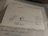
As for the map itself, I have seen several copies of it over the years. Most are the same, some have a few variations. The copies I remember seeing around the house when I was a kid, including ones brought over by visitors including Karl, did not have the words written on them. There have been a couple with words on them. If it were me transcribing the original map, it would have included words. I remember seeing versions with the words both on the front and on the back but written by the treasure hunter holder of the map copy. I cannot afford these more credibility than the random theories one finds on the internet these days. I used to have a copy of one with the words on it. Its around somewhere but I cannot validate who wrote on it. The words are on the front and in the lower right area of the map.
I have taken their base information that is in my Treasure Hunting hand me downs. I have expanded on the details as well as gained skills they didn't have to utilize such as navigating with a sextant. I have run a lot of research from the known locations and potential cache sites. I don't think the map is going to totally be utilized until the IAYAYAM key is figured out. There are three different cyphers this type of key fits into but without a starting key, reference or transposition of letter shifting that it will be figured out. I do suggest avoiding some of the theories circulating that are the creation of treasure hunter theorists but have no basis of being utilized historically.
There are also anomalies in this region that somehow tie in but not sure exactly. As an example, one is a round circle on the ground on the ridge of the San Luis Valley, it is white chalk like with three holes in the middle slightly larger than a grown person's finger. There is different colors in each of these holes. The holes line up and have a view of the San Dunes.
Its a lot like putting together a jigsaw puzzle upside down when you don't know how many pieces exist or what the final picture is. So, after years of staring at that map, I set it aside and sought reconstructing the history. This is going under the assumption that it is Spanish in origin. I am unable to make a connection to any other group that would have or could have been in the area such as Nazi's, French, Aztec, etc. But if you reconstruct the documented historical expansion and superimpose the theoretical or points taken at face value because it is the only information available (such as the named recovery sites) it fits like a glove.
I stepped back and took a different approach reconstructing the activities through other logistical means. FOr example, if there was a worked cache site, how many people were there back in the day? Where did they camp? Where did they get water? Where did they go to the bathroom. Then, comparing that information to known documented gold/silver locations. Knowing the gold is alluvial really narrows down where they could have been to find anything. In EACH of these target spots, I have found Spanish trail markers.
The trick is to stay objective and not get married to any idea that it had to be a certain thing, method, location, etc. If any treasure lead cannot be followed historically, then filter out what doesn't fit. It really comes down to breaking the code on the map or reconstructing historically then superimposing the results. So much of this time period was undocumented or the journals and orders have been hidden away in some historical archive.
My personal opinion is that we collectively stand a better chance of finding the cache sites by sharing information which is not the normal inclination of treasure hunters who want to keep their efforts and analysis secret.
To me, there is a big hole in the research regarding the map. I can take someone to spots where the map fits perfectly with the geography. But, I have not yet met the person who can cite the origin of the map, the current location, the accuracy of the map copies, etc. I remember listening to my father, Karl and a couple other treasure hunters sitting around the kitchen table and discussing aspects of the map as well so they did not have it broken either. The biggest progress I think was having the navigation expert in Britain use it and peg the general location.
So, yes, I am a LUE hunter. More specifically, I like to hunt the Spanish Cache sites and just accept that the map is one of the puzzle pieces. I have found much more knowing the region and using logic to locate stuff then retrofitting it to the map than decoding the map and following that. Its kind of like solving a maze by starting at the end and retracing to the beginning.
The fatal flaw is not knowing exactly what time period the map was drawn. I have heard many opinions on this and many of them make sense including the questions and challenges. Also, going on partial information such as the origin of Latitude (y coordinates) on maps date back to Claudius Ptolomy (90 - 168). These are well documented in his 8 volume Geographica. So assuming that Latitude was not used until the 1700s is an incorrect assumption that can misguide a navigator or treasure hunter.
I just don't want to get stalled trying to figure out the map when the same locations can be deduced with logic and analysis. That means I put less emphasis on the map and more on field research. I know I am in a general area when the trail markers are found. It would be like taking the recovery location at Black Lake or Mora and then backtracking the trail from the end toward the beginning.
These are just my thoughts on the subject.
Patrick


 (Playing Beverly Hillbillies "theme song").
![IMG_1017[1].webp IMG_1017[1].webp](https://www.treasurenet.com/data/attachments/1267/1267770-7da102eb0512020a84827f2211fe2c3d.jpg?hash=xtSZZoE0yC)
![IMG_1018[1].webp IMG_1018[1].webp](https://www.treasurenet.com/data/attachments/1267/1267791-619fba0992f0eb308251c618aac4f722.jpg?hash=sHiWb21HpD)
