LUE clue...the Obit of Hardrock Hammond

Randy:

You are, of course, correct! That obit was written by "KvonM." No doubt about it.

In the original edition of THM #6, pg. 85, is a photo of several th'ers as they "...await exit of Hardrock Hammond from cave." On page 217 is a photo of KvonM and Hammond at Vallecito. In the second set of photos in THM #7 is "Hardrock Hammond packing some rare and scarce 'vino' bottles back to the Kaplan ambulance during one of the Hammond-von Mueller sashays into old Mexico." Take a good look at that vehicle - then at the photo on page 95 of THM #6.

From the Encyclopedia of Buried Treasure Hunting: "Hardrock: W.A. Hammond, Recognized in professional circles as the Grand Old Man of THing."

I believe I've read a reference by KvonM that Hammond published a treasure hunting periodical - but I can't find it at the moment. I do know I've never seen a copy.

Good luck to all,

The Old Bookaroo
 

2.0 - KvonM dedicated The Treasure Hunter's Manual #6 (1961) to "Bill 'Hardrock' Hammond of Los Angeles."

What's that old saying about trees and the forest?

He never used that nickname, of course, but KvonM was a rock of a man himself. Pure ore.

Good luck to all,

The Old Bookaroo
 

One of the mid 1970s NPGs had a lot written in it about Hammond from Okie Jake Miller who was Karl's son. I read that a few weeks back and it sounded like Okie Jake spent a lot of time with Hammond as well before moving to England (I think to go to school). At the time it also sounded like Okie Jake was poised to take over the NPG for Karl, not sure what ever happened there. Miller makes it clear he spent a lot of times in the foothills with Hammond. "Hammond and Associates" were alleged to have made a LUE recovery. The first time I read that, I assumed it mean Hammond and friends...this obit above sorta spells out that Hammond and Associates was a formalized group and as best I can gather a precursor to the Circle of Companions. Circle of Companions was also an offshoot (per Karl) of an earlier group called KAFAN (?) which he briefly mentions in the Encyclopedia of Treasure Hunting.
 

Karl was a great author and a expert treasure hunter. He sold me my first detector, a White with a wood coil. God bless him.
 

The first edition of Sudden Wealth speaks very highly of Kenneth White. The RAM reprint substitutes, almost word for word, the same praise for Charles Garrett.

The Whites website history of Mr. White used to say he went from geiger counters to metal detectors after he read a book about treasure hunting. I've wondered, from time to time, what book that was.

KvonM's Coin Shooter's Manual remains an excellent introduction. He also wrote The Master Hunter Manual. The first couple of chapters provide first-rate advice for anyone using any detector.

Good luck to all,

The Old Bookaroo
 

Could somebody please tell me where San Francisco Peak, Colorado is.
 

Could somebody please tell me where San Francisco Peak, Colorado is.

dog, the usgs topos have no matching place name in CO. The closest match is San Francisco Pass - N 37.0389º, W 104.3516º.

sfpassco.jpg
 

mdog: There are the San Francisco peaks in Arizona - on the Colorado Plateau. I believe there is also a San Francisco mountain in New Mexico.

Depending on the era you're researching, I'd suggest you take a look at contemporary maps. Names change.

Good luck to all,

The Old Bookaroo
 

Maybe gold and silver are separate from the word mountains ,there is a Spanish peaks just to the north that the Utes named after two breasts.https://en.m.wikipedia.org/wiki/Spanish_Peaks.
And I think they are dead on your 105 mark
 

Last edited:
Maybe gold and silver are separate from the word mountains ,there is a Spanish peaks just to the north that the Utes named after two breasts.https://en.m.wikipedia.org/wiki/Spanish_Peaks.
And I think they are dead on your 105 mark

Thanks Kanabite. I was looking at Randy's posts 6 and 13 and noticed the places mentioned are pretty close to the same longitude. I've read about this connection before, that's why I was looking for San Francisco Peak close to the 105, actually I was looking at 105 degrees 16'.
 

Thanks Kanabite. I was looking at Randy's posts 6 and 13 and noticed the places mentioned are pretty close to the same longitude. I've read about this connection before, that's why I was looking for San Francisco Peak close to the 105, actually I was looking at 105 degrees 16'.

Interesting meridian. Here's a quick list of some sites on or very close to 105° 16' long, between latitudes north of Albuquerque and south of Denver:

Montezuma NM (35° lat), where Armand Hammer, an oil tycoon and son of a famous revolutionary, had a big presence.
San Isidro Lake NM (35° 52' lat), a nice heart-shaped body of water (we like these).
Angle Fire NM (36° 23' lat).
Eagle Nest NM, lake and some sort of excavation/gravel pit site (36° 34' lat).
Elizabethtown NM (36° 37' lat), an historic gold-mining site (we like gold mines).
Black Mountain NM (36° 42' lat), an important place name (IMO).
Black Mountain CO (37° 51' lat), an important place name (IMO).
Florissant CO (38° 57' lat), "prosperous" in French. That's good.
Cathedral Spires CO (39° 25' lat), a significant landmark.
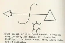

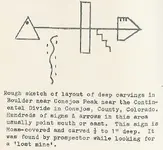
Eagle Nest NM is associated with the Black Lake cache...important because New Mexico has like 3 different 'black lake's."
Elizabethtown as noted previously was also a reported cache site.

Keep in mind, Karl emphasized the importance of the 105 12 1/2 parallel but never, to my knowledge, explained how he came by this. Also keep in mind that several other reported cache recoveries occurred at ghost towns so they may not show up on current place names or atlases.
 

Interesting meridian. Here's a quick list of some sites on or very close to 105° 16' long, between latitudes north of Albuquerque and south of Denver:

Montezuma NM (35° lat), where Armand Hammer, an oil tycoon and son of a famous revolutionary, had a big presence.
San Isidro Lake NM (35° 52' lat), a nice heart-shaped body of water (we like these).
Angle Fire NM (36° 23' lat).
Eagle Nest NM, lake and some sort of excavation/gravel pit site (36° 34' lat).
Elizabethtown NM (36° 37' lat), an historic gold-mining site (we like gold mines).
Black Mountain NM (36° 42' lat), an important place name (IMO).
Black Mountain CO (37° 51' lat), an important place name (IMO).
Florissant CO (38° 57' lat), "prosperous" in French. That's good.
Cathedral Spires CO (39° 25' lat), a significant landmark.

Thanks Sdcfia. If you go further south in Lincoln County, you run into Capitan Peak. I missed the San Isidro Lake, good one. For those of you who don't know, Sdcfia and I like to study maps and run lines. We've found some interesting connections. Sdcfia has the best one. It involved the Peace Garden at the U.S. and Canadian border.

I have a thread in the Treasure Legends forum titled Something New About the LUE, in it, I write about Black Mountain, Colorado and Capitan Peak. This is the line Sdcfia and me were looking at. These lines could be important to LUE researchers. Capitan Peak is on another treasure line that starts at the Oak Island money pit and ends at Victorio Peak. There is an alleged Captain Kid treasure legend on that line as well, I write about that one in my thread in the KGC forum titled, Things For Further Research.
 

Both of these maps come from my presentation. The first is an overview of the recovery points and their relationship to the 105 12.5 meridian.

LUE recovery Points.jpg

This is the same map, simply with some key points of interest that may or may not be relevant to orienting the LUE.

LUE Keypoints.jpg
La Cueva and Conejos Peak are relevant because:

ToVS LUE First.jpgToVS LUE Second.jpg
 

Last edited:

Top Member Reactions

Users who are viewing this thread

Back
Top