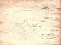
Here is a map that I have puzzled over for quite awhile---

It depicts the traditional "pit-tunnel-cave" configuration, with the cave (casa caverna) on the opposite side of the creek as the pit mine and tunnel. And it has a big needle to the South, with the Salt River to the North.
But the rest of the map doesn't fit with anything else.
It's as though two different people contributed to making this map.
Suppose there were two different people, trying to combine what they each knew, into one map?
Suppose one guy, call him Jose, was stationed at the "Campo Mayor," and the other guy, Pancho, worked at the arrastres or placers? Maybe they were friends or related, or just met up later, and tried to make an overall map of where the mines were, by combining what each one knew?
It would make sense that the top dogs wouldn't want any one person to know everything, and thus be able to come back and lead a large group of people right to the mines.
So, Jose worked at the Campo. It's on the river, so they could monitor who was coming into the area from Northwest. And from a high point just South of Campo, they could see anyone coming in from the flat area to the West. Good spot in that respect.
And say that Jose would, among other things, help bring supplies to the mine. So he would know that they went South-Southeasterly, and started going up onto Black Mesa just as they got near the Three Red Hills. He would know that they crossed over the top of Black Mesa, and that there were three drainages emanating from about where they crossed the top, all as shown on his part of the map.
But here is where he starts guessing. They go down the other side of Black Mesa, but not right away. They don't take the first drainage down to Boulder. Instead, they follow a drainage Southward, which is one hill West of Boulder Creek. Then they drop down and cross Boulder here---

But he thinks that
Boulder is just the drainage which they didn't go down (dotted yellow line), when they turned Southward on Black Mesa. So then they go over the hump to La Barge, and cross it. He asks where it goes, and someone tells him that it goes Northward, and that it, and the creek they previously crossed, come together. He assumes that they come together nearby, and that's why he shows two creeks coming together on his part of the map, after coming off Black Mesa. Then he continues on to the valley with the pit-tunnel-cave layout.
He knows about "Red River" feeding into the Salt, but he doesn't know where it comes from, exactly. Maybe at some point he went by boat or raft Eastward to the arrastres, and saw it then, or maybe was on a scouting party, or just knew of it by word of mouth. He doesn't know that it follows the contours of Black Mesa, and that
it is actually what he thought was part of the first drainage. He saw the North drainage off of Black Mesa, and figured that was the source of his "Red River."
Now Jose gets together with his friend Pancho, later on, and they try to figure out where, exactly, the hard rock mines are located. Kind of triangulate it, and get their bearings on where it is, so they could possibly reach it from different directions, or relay that information to their relatives.
So Pancho tells him that he has been with the group who takes supplies to the mines, also. But his starting point is the arrastres. He says they go Southward, on the West side of Black Canyon (Tortilla Creek), then cross over a creek (Peter's canyon creek) which branches off of the West side of Black Canyon. And that is where the smaller camp is. There is a trail that continues on, in a Southernly direction to the West side of another creek, where there is a small mine.
When Pancho had asked the people in this smaller camp, where the pit-tunnel-cave is located, it's all hush-hush, so they tell him it's further up the creek (Tortilla/Black Canyon) that the small mine trail goes to. But he is not allowed to go further down that trail. When he asks where the creek, that the camp is on, goes to, they say it doesn't lead anywhere, but it just goes South (but this is the real route to the pit-tunnel-cave).
When Jose and Pancho compare notes, they assume that Peter's, which is the real "Arroyo Caverna," goes South and must be the one that Jose saw after crossing the hump between Boulder and La Barge Creeks/Canyons, so they draw it in there. After all, it's got to go somewhere, and Jose did see a creek there.
Additionally, it could be that Jose was not allowed to approach the pit-tunnel-cave, either. Maybe the rock miners came down to La Barge to pick up their supplies. So Jose only knew that the mine was on the other side of the Creek (La Barge) and up that drainage a ways. So Pancho's "creek to nowhere" must be the one that Jose saw at the "hump," because from that creek, the rock mines appeared to him to be up high, and creeks don't flow up hill, so the mystery creek couldn't be up there.
If neither Jose nor Pancho ever actually saw the pit-tunnel-cave, then there may have even been a third partner in the map making.
If so, it would probably have been a rock miner. And the miners would probably not have been allowed to go to either the Campo Mayor or the arrastres/placers, because the top dogs didn't want them mingling. This could explain why the map shows the "Arroyo Caverna" coming down off a hill on the map, because there is a drainage in the valley, on West side, where the trail in from La Barge is. The rock miner may have seen water coming down there, and thought that it was the source for Peter's Creek/Canyon, because just South of that is a very sharp bend, with steep sides, in Peter's, and it obscured his view of the real source of the flow. It may have been that those miners were made to stick to their one work spot, and were not allowed to wander around, both to get the work done and to prevent anyone from wising up to the full layout. But they would have had to mingle and talk, because whoever made that map seemed to know at least approximately what was there.
The map shows a continuation of "Canyon Negra," after the Southmost branch. But there is no major branching off of Tortilla Creek, past Peter's. Possibly, the third guy, the rock miner, told Jose and Pancho about there being a fork just North of the pit-tunnel-cave complex, and they figured it was their Black Canyon continuing on Southward.
On the other hand, maybe some drunk, in a bar in Phoenix, drew the map after hearing lots of rumors and treasure stories....