Legend of the Stone Maps

I think Father Kino SJ got AT LEAST to the Salt River. Look on Kino's Map and you will see Moqui Indian Villages at the top right.Mike

Mike,

I believe you are mistaken here. There is no evidence that Father Kino ever traveled north of the Gila River. Their information concerning the Moqui Indians and their villages came, primarily, from the Pima Indians. From "Luz De Tierra Incognita" we get this from Juan Mateo Manje:

"For several years past, as related by the older Pimas, the Sobaipuris had trading communication with the Moquinos, establishing fairs and markets among themselves. this is the reason the Pimas give such accurate information on the Province of Moqui, of the locations of their pueblos, of their government and other matters."

Nowhere does Manje say that they entered the land of the Moqui or even made personal contact with them. Manje's diary is extensive and the most accurate account of their travels. What makes you believe Father Kino visited the Moqui villages, beyond the fact that they are shown on his maps?:dontknow:

Take care,

Joe

Hey Joe,

Hope y'all are doing well.

If what you say is true, then how did Manje know that the Pima Information was so accurate (...this is the reason the Pimas give such accurate information on the Province of Moqui...), if he hadn't been there to see for himself?

Here is a quote from The History of Arizona and New Mexico" Chapter XV:

Again, in 1698, Kino returned by way of Bac to the Gila; and from San Andres, the limit of the previous trip, or from the region of the Pima villages of modern maps, he crossed the country southwestwardly to Sonoita and the gulf shore; but unfortunately, Mange’s place was taken by Captain Carrasco, and no particulars affecting Arizona are extant. In the next tour of 1699 with Mange, he went first to Sonoita via Saric; and thence crossed north-westward to the Gila at a point about ten miles above the Colorado junction. The natives refused to guide him down the river where he had intended to go; therefore he went up the river eastward, cutting off the big bend, sighting and naming the Salado and Verde rivers, from a mountain top, reaching San Andres Coata where he had been before, and returning home by the old route via Encarnación, San Clemente, San Agustin, and Bac. In this trip he called the Colorado Rio de los Mártires, the Gila Rio de los Apóstoles, and the four branches of the latter—that is, the Salado, Verde, Santa Cruz, and San Pedro—Los Evangelistas.

So, yes, he got further North than the Gila River and Casa Grande.

Mike
 

Mike,

[Again, in 1698, Kino returned by way of Bac to the Gila; and from San Andres, the limit of the previous trip, or from the region of the Pima villages of modern maps, he crossed the country southwestwardly to Sonoita and the gulf shore; but unfortunately, Mange’s place was taken by Captain Carrasco, and no particulars affecting Arizona are extant. In the next tour of 1699 with Mange, he went first to Sonoita via Saric; and thence crossed north-westward to the Gila at a point about ten miles above the Colorado junction. The natives refused to guide him down the river where he had intended to go; therefore he went up the river eastward, cutting off the big bend, sighting and naming the Salado and Verde rivers, from a mountain top, reaching San Andres Coata where he had been before, and returning home by the old route via Encarnación, San Clemente, San Agustin, and Bac. In this trip he called the Colorado Rio de los Mártires, the Gila Rio de los Apóstoles, and the four branches of the latter—that is, the Salado, Verde, Santa Cruz, and San Pedro—Los Evangelistas.]

You could be right, but from what I have read he did not go north of the Gila River.

Take care,

Joe
 

You can't believe everything you read Joe, Have you not read my posts.

Take care Joe
 

That is an old camera

real rough edges actually.......

I bet the copy we see was the one altered to guide the hunt to the entrance going up to Miner's Needle and Weaver's needle from Massacre Point.

Part of the finders way of altering the copies to make the one set of lines seem more like the Needle?

Just my guess seeing the difference to the two stones we have seen.

could you post an img, of which heart insert you think is a copy
 

Mike,

I know it's in bad form to trust anything you read, but from what I have read of the Moqui Tribe, if Kino had reached their lands, chances are he would have died there. Very warlike people. Beyond that, neither Kino nor Manje mentioned any meetings with the Moqui. They were often mentioned as a tribe that Father Kino would have liked to see brought into the Catholic faith, as well as into the king's fold.

Why do you feel it is important to change accepted history and have Father Kino make it beyond the Gila?

Take care,

Joe
 

could you post an img, of which heart insert you think is a copy

LATIN_HEART_2.jpg

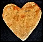
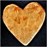
Notice the rounded edges here whereas on the OP's heart stone there are more serious divets around the corners.....
 

I was asked two posts above to reference these facts.....i grabbed the first one I found off the internet....

big mistake....as if I haven't shown a ton off by now......let me try to reiterate the point I was making....

CW0909 asked for the other copies, I made one mistake and get the lashings.....LOL

Anyways there are two copies to look at online, and you will have to search for them, but everyone here can attest to the fact that when the clay versions were made they were clearly altered a bit to remove certain marks, while adjusting others to carry their own version ....

IE specifically the mark in reference in so many other's posts that looked like Weaver's Needle.

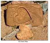
The reality is that the object in question from the original, takes the shape of rivers that cross over that border where the heart is inlaid, and the format of the clay replications were more similar to the Needle, having been produced after the succession of explorers had made their attempts to identify that mark as the needle, influencing the Mining Company to simply accept that as a clue and reference point.

Its obvious as to the fact that the rivers and streams are drawn there in the map stone, and that they continue into the heart stone area,

Dont think they were carved to then evolve into the Needle....seems out of context.

Sorry for the confusion, but both sets of stones can be found, and the previous thread here in this subject topic can be found as well.

OOPS

View attachment bill2-Trail-Map.bmp Clay Version Made to look like Miners Needle

heart008.jpgSame Version in a Better Light Showing the Miners Needle-looking marks are more "obvious" when seperated from the clay version

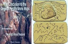
attachment.php.jpg Here they are doctored to exclude the needle altogether
 

Last edited:
Mike,

[Again, in 1698, Kino returned by way of Bac to the Gila; and from San Andres, the limit of the previous trip, or from the region of the Pima villages of modern maps, he crossed the country southwestwardly to Sonoita and the gulf shore; but unfortunately, Mange’s place was taken by Captain Carrasco, and no particulars affecting Arizona are extant. In the next tour of 1699 with Mange, he went first to Sonoita via Saric; and thence crossed north-westward to the Gila at a point about ten miles above the Colorado junction. The natives refused to guide him down the river where he had intended to go; therefore he went up the river eastward, cutting off the big bend, sighting and naming the Salado and Verde rivers, from a mountain top, reaching San Andres Coata where he had been before, and returning home by the old route via Encarnación, San Clemente, San Agustin, and Bac. In this trip he called the Colorado Rio de los Mártires, the Gila Rio de los Apóstoles, and the four branches of the latter–that is, the Salado, Verde, Santa Cruz, and San Pedro–Los Evangelistas.]

You could be right, but from what I have read he did not go north of the Gila River.

Take care,

Joe

Since there's very little in the way of rational discussion on this forum right now, I thought I'd take this up in debate.

Are you aware that on the 1702 map by Kino, there is a river on it called Rio Azul or Blau Fluss, both meaning "blue river," which later came to be known as the Verde river? As you may know the Verde River confluence isn't visible from anywhere but the Salt River Valley, so for him to have named it from a mountaintop south of the Gila isn't possible by any stretch of the imagination.

The idea that Kino marked the territory northeast of the Salt River "Moqui" is, as most are led to believe, rooted in his interest in meeting them with the goal of christening them. However, and conveniently, I may add, the naming of the Verde River originally as Rio Azul isn't an accident as Rio Azul is a name thought to have been connected to the legend of a mountain of gold, located somewhere in the vicinity of the Moqui villages, known as Sierra Azul. So Kino's goal of going there was probably twofold.

Mike,

I know it's in bad form to trust anything you read, but from what I have read of the Moqui Tribe, if Kino had reached their lands, chances are he would have died there. Very warlike people. Beyond that, neither Kino nor Manje mentioned any meetings with the Moqui. They were often mentioned as a tribe that Father Kino would have liked to see brought into the Catholic faith, as well as into the king's fold.

Why do you feel it is important to change accepted history and have Father Kino make it beyond the Gila?

Take care,

Joe

Manje did not travel with Kino on every one of his journeys as you know, he only traveled on a handful of Kino's tireless voyages. Many of those trips sometimes didn't even involve another white man, and sometimes even consisted just of Kino, his Indian servants, and a retinue of horses. As an interesting side note, the Salt River wild horses are rumored to have been introduced to the region from Kino's stock. He was known for running his horses into the ground.

So to take Manje's account of Kino as being comprehensive as far as a profile of Kino's journeys, is misleading.

And as we know, Kino's later journals and his astrolabe is missing, so likely we will never have a full understanding of what exactly he did in the Pimeria Alta.

Although Kino isn't recorded as having gone that far up north, Fr. Campos was. Fr. Campos had, in the words of none other than your favorite revisionist historian, Charles W. Polzer, "penetrated the White Mountains in search of the Moqui."

That would put him way north of the Gila River...... wouldn't it?
 

Since there's very little in the way of rational discussion on this forum right now, I thought I'd take this up in debate.

Are you aware that on the 1702 map by Kino, there is a river on it called Rio Azul or Blau Fluss, both meaning "blue river," which later came to be known as the Verde river? As you may know the Verde River confluence isn't visible from anywhere but the Salt River Valley, so for him to have named it from a mountaintop south of the Gila isn't possible by any stretch of the imagination.

The idea that Kino marked the territory northeast of the Salt River "Moqui" is, as most are led to believe, rooted in his interest in meeting them with the goal of christening them. However, and conveniently, I may add, the naming of the Verde River originally as Rio Azul isn't an accident as Rio Azul is a name thought to have been connected to the legend of a mountain of gold, located somewhere in the vicinity of the Moqui villages, known as Sierra Azul. So Kino's goal of going there was probably twofold.

Manje did not travel with Kino on every one of his journeys as you know, he only traveled on a handful of Kino's tireless voyages. Many of those trips sometimes didn't even involve another white man, and sometimes even consisted just of Kino, his Indian servants, and a retinue of horses. As an interesting side note, the Salt River wild horses are rumored to have been introduced to the region from Kino's stock. He was known for running his horses into the ground.

So to take Manje's account of Kino as being comprehensive as far as a profile of Kino's journeys, is misleading.

And as we know, Kino's later journals and his astrolabe is missing, so likely we will never have a full understanding of what exactly he did in the Pimeria Alta.

Although Kino isn't recorded as having gone that far up north, Fr. Campos was. Fr. Campos had, in the words of none other than your favorite revisionist historian, Charles W. Polzer, "penetrated the White Mountains in search of the Moqui."

That would put him way north of the Gila River...... wouldn't it?

Kino likely placed the Moquis on his map based on information known beginning with the Coronado and Espejo expeditions in the 16th century, where contact with the tribe in their villages was established.

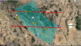
The Sierra Azul legend is interesting. History Lesson: The Legend of Sierra Azul - The Verde Independent - Cottonwood, Arizona This mountain of gold legend seems similar to the Cibola rumors - a fabulously rich location placed all over Primeria Alta, depending on who's repeating the story. The late 17th century Posadas report to the King seems to be the most specific locational description of the site, at least from a cartographic basis - 100 leagues "southwest of Santa Fe" and 50 leagues "north of Sonora" (the contemporary league was 5000 varas - 2.6 miles). Below shows the directional 45 degree southwest arc with a +/- 20% distance band from Santa Fe. Depending on where the Sonoran border was assumed to be by Posadas (I used today's for convenience), the two red lines represent +/- 20% distance error, establishing a rough Posadas search zone. Since Posadas' report was written not long before the Kino years, Kino may have been aware of it.

If Kino went treasure hunting on the sly during his Primeria Alta years, perhaps Sierra Azul was one of his targets. If so, and he used Posadas' information, he very well could have ventured considerably north of the Gila - maybe even as far east as the Gila headwaters region. Whether he found the Moqui or not, he certainly could have been in the White Mountains.

Blue Mtn.jpg
 

Last edited:
Kino likely placed the Moquis on his map based on information known beginning with the Coronado and Espejo expeditions in the 16th century, where contact with the tribe in their villages was established.

The Sierra Azul legend is interesting. History Lesson: The Legend of Sierra Azul - The Verde Independent - Cottonwood, Arizona This mountain of gold legend seems similar to the Cibola rumors - a fabulously rich location placed all over Primeria Alta, depending on who's repeating the story. The late 17th century Posadas report to the King seems to be the most specific locational description of the site, at least from a cartographic basis - 100 leagues "southwest of Santa Fe" and 50 leagues "north of Sonora" (the contemporary league was 500 varas - 2.6 miles). Below shows the directional 45 degree southwest arc with a +/- 20% distance band from Santa Fe. Depending on where the Sonoran border was assumed to be by Posadas (I used today's for convenience), the two red lines represent +/- 20% distance error, establishing a rough Posadas search zone. Since Posadas' report was written not long before the Kino years, Kino may have been aware of it.

If Kino went treasure hunting on the sly during his Primeria Alta years, perhaps Sierra Azul was one of his targets. If so, and he used Posadas' information, he very well could have ventured considerably north of the Gila - maybe even as far east as the Gila headwaters region. Whether he found the Moqui or not, he certainly could have been in the White Mountains.

View attachment 1196907


sdcfia,

While what deducer says is true, that Father Kino did some of his travels with others, without Manje, and alone, he never records going or attempting to go to the Moqui villages. His maps from that era were known to have some serious flaws, wonderful though they were. He also had maps from earlier explorations, but did not know the authors.

It has been written that he greatly desired to bring the Moquis to the religion of the church, but he had decided to skirt the region to the east and visit them in New Mexico. He would not have attempted to travel Apacheria alone or without a large party of the military. If he had, and survived, he would have written about it.

While it's interesting to speculate that such a trip was in his missing records or was "scrubbed" by the church, there is no logical reason to explain such unrecorded contact with the Moqui.

The 1702 Kino map, referred to by deducer, is not accurate. It does not take much research to see that fact.

In "Rim of Christendom" by Herbert Bolton, while the Moqui and their lands are mentioned, there is nothing to suggest that Father Kino ever made contact with them.

It may be that I am mistaken, but my memory is not good enough to find the mistake. I will make the attempt to reread the pertinent passages, but may not find the Bolton quote that deducer has found.

There are a number of mountain tops from which you can see the Salt River. They range from around 21 miles down to 4.
There is little doubt that Father Kino did step foot on the north side of the Gila. In that respect, he could not leave the protection of the friendly tribes who lived on the Gila.

Good luck,

Joe Ribaudo
 

Joe, if Kino visited the Hopi, he obviously had little or no effect on them. By his time, these natives had the European invaders pretty well figured out. The Spanish made several efforts to "subdue" the Hopi with quite limited longterm success, then pretty much gave up their efforts in the 18th century and left them alone after that. Some Christian groups managed to weasel their way into the tribe over the years, but many Hopi were able to ignore them or placate them and keep their old ways, even to the present. Same goes for the Taos natives in New Mexico, where the Franciscans and others have had minor presences over the centuries, especially after 1680.

Just because Kino, other clerics, the Spanish and free agents failed to document all their activities doesn't necessarily disprove that some things may have been done that they wished to remain private. Humans often carry out agendas that they don't want others to know about.
 

Last edited:
Joe, if Kino visited the Hopi, he obviously had little or no effect on them. By his time, these natives had the European invaders pretty well figured out. The Spanish made several efforts to "subdue" the Hopi with quite limited longterm success, then pretty much gave up their efforts in the 18th century and left them alone after that. Some Christian groups managed to weasel their way into the tribe over the years, but many Hopi were able to ignore them or placate them and keep their old ways, even to the present. Same goes for the Taos natives in New Mexico, where the Franciscans and others have had minor presences over the centuries, especially after 1680.

Just because Kino, other clerics, the Spanish and free agents failed to document all their activities doesn't necessarily prove that some things may have been done that the protagonists wished to remain private. Humans often carry out agendas that they don't want others to know about.

sdcfia,

What Father Kino or others "may" have done does not change accepted history. The only thing that will change what has been written, is hard evidence. Deducer will need to quote his Bolton source, and I have doubts that will change the history books.

Father Kino and Juan Mateo Manje's diaries are the best evidence available to us. That remains true whether they are fact or fiction. Neither man mentions traveling to the Moqui villages, although they mention the Moqui many times.

Good luck,

Joe Ribaudo
 

While what deducer says is true, that Father Kino did some of his travels with others, without Manje, and alone, he never records going or attempting to go to the Moqui villages. His maps from that era were known to have some serious flaws, wonderful though they were. He also had maps from earlier explorations, but did not know the authors.

It has been written that he greatly desired to bring the Moquis to the religion of the church, but he had decided to skirt the region to the east and visit them in New Mexico. He would not have attempted to travel Apacheria alone or without a large party of the military. If he had, and survived, he would have written about it.

While it's interesting to speculate that such a trip was in his missing records or was "scrubbed" by the church, there is no logical reason to explain such unrecorded contact with the Moqui.

The 1702 Kino map, referred to by deducer, is not accurate. It does not take much research to see that fact.

The accuracy of said map isn't the subject as much as the choice of the name, Rio Azul, given to what eventually was named the Verde river.

In "Rim of Christendom" by Herbert Bolton, while the Moqui and their lands are mentioned, there is nothing to suggest that Father Kino ever made contact with them.

It may be that I am mistaken, but my memory is not good enough to find the mistake. I will make the attempt to reread the pertinent passages, but may not find the Bolton quote that deducer has found.

The quote regarding Fr. Campos going as far north as the White Mountains of Arizona isn't from Bolton, it's from The Presidio and Militia on the Northern Frontier of New Spain: 1570-1700 edited by Thomas H. Naylor, Charles W. Polzer, page 627.

There are a number of mountain tops from which you can see the Salt River. They range from around 21 miles down to 4.
There is little doubt that Father Kino did step foot on the north side of the Gila. In that respect, he could not leave the protection of the friendly tribes who lived on the Gila.

If I'm not wrong, it is approximately 30 miles, as the crow flies, from the Gila river to the Salt River. So any of those "mountaintops" would be well within the area "north of the Gila," correct?

Do you also have any idea how he knew to name it the Salt river?
 

Top Member Reactions

Users who are viewing this thread

Back
Top