Is the Pit Mine really the Lost Dutchman mine?

No Joe, Glover went to a military museum, Not even close to military records, Uncle Mark spent his life in Arizona and New Mexico. Became a top high ranking officer in the military. I'll stay with his word and his maps. The trail went north of Phoenix then split east and west part of it can be seen over by fountain Hills,Wrmickel1 Even Holmes story is a yarn, most likely never even new Waltz, other wise why the confusion of the name. Yarn!

Wrm,

It's nice having Uncle Mark's input here. How about posting some pictures of his maps.....:dontknow:

Good luck,

Joe
 

wrmickel1 wrote : If waltz traveled north from his home there would be know reason to go to the milk ranch, Your lost in translation, Now heading home yeah why not stop there Sure. There is only one recorded military road going North from Waltz's house Glover got it wrong as I said to Joe, He chose to believe Glover, Ohh Well!


You are correct but at the same time so is cactusjumper because you are talking about two separate issues.
TE Glover obtained his Military maps from the War College in Washington. But those maps don't show every road used by the Military in the 1864 - 1874 time period.
When Phoenix was first settled in 1868 a road ran from Phoenix to Fort McDowell and it was indeed north of Phoenix and ran north of the Salt River. Both civilians and Military used this road.

So yes, Waltz using this road would have traveled north from his home and then northeast toward McDowell on this "military road". This would have been the road Waltz used when going through Agua Escondido (Hidden Water) and then crossing the Salt at Cottonwood Canyon (Monroy Ranch) area into the Superstitions. And yes, you are right, this road went right through present day Fountain Hills.

You seem to believe Waltz only went one way to the Superstitions. In fact, he could go any number of ways. The north way to Agua Escondido, or go the south route to Mesa (Levi) and the southwest side of the Superstitions.
Waltz said, he never went by the same route or returned by the same route.

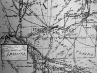
Az Territory map 1880.jpg

This 1880 Territory map shows that road north of the Phoenix settlement going to Ft. McDowell in the upper right corner.

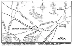
1868 Az. Terr. Map.jpg

This map drawn from the 1868 Ingall's survey shows that same road from Phoenix to McDowell. This road was actually in place in 1865 as soon as McDowell was built.
All of the hay that was used at McDowell was grown along the Salt River at "Phoenix" and freighted to McDowell.

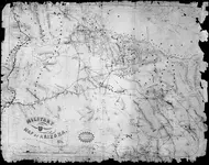
1869 Arizona Terr. Military map..jpg

This is a map TE Glover missed. My scan is unfortunately too small for it to be read legibly here. It is an 1869 Arizona Territory map showing both the Military and Civilian routes.

Matthew
 

The Southwest side of the Superstitions, today known as the Barkley Basin, where four unidentified men followed Waltz to Whiskey Springs Canyon and lost him there, if I'm not wrong.
 

Matthew nice post

A lot of the old military records are still in Az,Nm I've personally seen the file on Roswell 1947 I believe that was the year.
The first statement by the Airforce is the real conclusion in the investigation. Not a ballon.
But anyway there's only a couple pieces of all the Dutchman yarn I believe to be True.

The first five or so of clues, Julia was at his deathbed no one else, And he had a sister he sent money to. And here's why

I tracked down a family in the south, That are 3rd generation to Waltz, They don't know a hole lot about it except what was passed down. There Great Grandmother had a brother that lived in punkin patch territory. I never new where that was till I asked Joe a few years back, He new the answer and told me, They said her brother would send her money now and then and when he died he left it to a woman named Julia And that is all they new. But the real kicker to this is the last name. It's not Waltz, and this fellow did file a claim, And yes I know exactly where it is. But I think you might know it to for some reason or a bother.

Julia drew a horse on her map yet the Stones weren't found till the 40's there is no know reason for the horse to be on that map, Unless Waltz told her about the horse, it sits outside a tunnel on a trail with a room or two in the back.

And the first five or so clues line up.

Wrmickel1. But I got more pic's coming just not the time quite yet
 

One last side note, This Waltz is buried along side his sister and her husband right there on the family farm, So who's head stone is in Phoenix

Wrmickel1
 

Now I read a story they replotted and shifted the headstone because a scan showed no body under Waltz's Headstone'

Most likely it was just placed there buy Julia and the body was sent home, Probably Jacobs last request or his Sisters.

Wrmickel1
 

The Southwest side of the Superstitions, today known as the Barkley Basin, where four unidentified men followed Waltz to Whiskey Springs Canyon and lost him there, if I'm not wrong.

Deducer

I believe that as just some good old creative writing no more then a story to creating a endearing ledgen.

Most of this happens today yet, Oh I new him or people confessing to a murder so they gain fame.

wrmickel1. Piles and piles of dung welded into a story and a time line.
 

Wrm,

It's nice having Uncle Mark's input here. How about posting some pictures of his maps.....:dontknow:


Good luck,

Joe

Joe just early Maps nothing Special, I think you know enough about the Military trails.
but I will share this pick. Not saying where I got it.

Meet Mr. Roswell


IMG_0640.JPG

Wrmickel1
 

............snip..........

You have to remember those are Tonto National Forest trails that were put in from the 1930's through the 1960's and were not established in Waltz's time.
The Fraser ranch is the reason for the trail going east from approximately the Barkley Basin over to Fraser Ranch and that ranch wasn't there when Waltz was working his mine.
I will concede however that if someone knew how to get thru that country they could have made it to the area of the Pit Mine but it would have been a tortuous round about way to go.
It's 6-7 miles of winding around canyons and impasses. Still, it could be done if someone knew the route and had enough time and energy to try it.
One thing I've learned is you can't rule anything out or shortchange those old timers ability and determination............<<


I'll concede I do not have first hand knowledge of the trails. But; <g> this looks like a Military East-West Route to me. They didn't have time on their tour of duty to build this route so I can only surmise it was an existing trail. Could be wrong....... circa. 1873
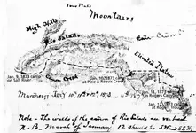
Bourke-Map-Jan_-6-12-1873-Courtesy-Jack-Carlson-Elizabeth-Stewart.jpg
 

............snip..........

You have to remember those are Tonto National Forest trails that were put in from the 1930's through the 1960's and were not established in Waltz's time.
The Fraser ranch is the reason for the trail going east from approximately the Barkley Basin over to Fraser Ranch and that ranch wasn't there when Waltz was working his mine.
I will concede however that if someone knew how to get thru that country they could have made it to the area of the Pit Mine but it would have been a tortuous round about way to go.
It's 6-7 miles of winding around canyons and impasses. Still, it could be done if someone knew the route and had enough time and energy to try it.
One thing I've learned is you can't rule anything out or shortchange those old timers ability and determination............<<


I'll concede I do not have first hand knowledge of the trails. But; <g> this looks like a Military East-West Route to me. They didn't have time on their tour of duty to build this route so I can only surmise it was an existing trail. Could be wrong....... circa. 1873
View attachment 1496592

Old,

Nice work. I was going to go to Bourk's notes to bolster my position, but have had company lately and didn's take the time. I will eventually get to it.

Nice post,

Joe
 

............snip..........

You have to remember those are Tonto National Forest trails that were put in from the 1930's through the 1960's and were not established in Waltz's time.
The Fraser ranch is the reason for the trail going east from approximately the Barkley Basin over to Fraser Ranch and that ranch wasn't there when Waltz was working his mine.
I will concede however that if someone knew how to get thru that country they could have made it to the area of the Pit Mine but it would have been a tortuous round about way to go.
It's 6-7 miles of winding around canyons and impasses. Still, it could be done if someone knew the route and had enough time and energy to try it.
One thing I've learned is you can't rule anything out or shortchange those old timers ability and determination............<<


I'll concede I do not have first hand knowledge of the trails. But; <g> this looks like a Military East-West Route to me. They didn't have time on their tour of duty to build this route so I can only surmise it was an existing trail. Could be wrong....... circa. 1873
View attachment 1496592


Old,

The map you are referencing is not of an existing trail Bourke followed but rather a march he took following some Apaches. So there was no existing east - west trail he was on. He simply was following Apaches wherever they were headed.

The map is also updated by a modern day author who draws in his own interpretation of where Bourke MAY HAVE been and camped and the references to the Rogers area are 100% his, not Bourke's. In fact if you read Bourke's actual diary and look at the map it appears the modern day author shifted everything to try and prove the route was in the area of a mine he was promoting (the Pit Mine).

Lastly, the Bourke map goes no where near the "Milk Ranch" we were discussing, neither does the modern day authors drawings and comments have anything to do with the Milk Ranch.

But the map is a good historical find, it just has nothing to do with the Milk Ranch or the route from the Milk Ranch to the "Pit Mine".

Best,

Matthew
 

I believe , to not write how I am sure , the board house that Waltz were referring was the Quarter U ranch .
But I wouldn't take that point as a permanent route to the LDM , because as Matthew wrote , Waltz used all the possible paths that could lead him to his mine .
 

Last edited:
I believe , to not write how I am sure , the board house that Waltz were referring was the Quarter U ranch .
But I wouldn't take that point as a permanent route to the LDM , because as Matthew wrote , Waltz used all the possible paths that could lead him to his mine .

markmar,

You are correct that the "Board house" Jacob Waltz talked about was the Matt Cavaness Ranch which later was owned by Jim Bark and later Tex Barkley, the Quarter Circle U Ranch.

We know this because Waltz named "Mrs. Cavaness" as living there.

The "Milk Ranch" was also built by Matt Cavaness but his mother-in-law Mrs. Rowe lived there with her youngest children.
Her husband, William Rowe had been murdered at Maryville on the Salt River and his wife and children came to live near their oldest daughter who was married to Matt Cavaness.

Jacob Waltz told Rhiney Petrasch that he never returned to Phoenix by the route he took to go to the mine and he never went by the same route twice.

A wise precaution and proves he came and went from his mine by at least two and possibly more routes.

Matthew
 

Old,

The map you are referencing is not of an existing trail Bourke followed but rather a march he took following some Apaches. So there was no existing east - west trail he was on. He simply was following Apaches wherever they were headed.

The map is also updated by a modern day author who draws in his own interpretation of where Bourke MAY HAVE been and camped and the references to the Rogers area are 100% his, not Bourke's. In fact if you read Bourke's actual diary and look at the map it appears the modern day author shifted everything to try and prove the route was in the area of a mine he was promoting (the Pit Mine).

Lastly, the Bourke map goes no where near the "Milk Ranch" we were discussing, neither does the modern day authors drawings and comments have anything to do with the Milk Ranch.

But the map is a good historical find, it just has nothing to do with the Milk Ranch or the route from the Milk Ranch to the "Pit Mine".

Best,

Matthew

Great post!

My how new is that, someone distorted the True to match there theory.
I must be a different breed of treasure hunter. If it's not there it's not part of the equation. But I do believe you can see the ( for Joe ) THE ONE AND ONLY MILITARY TRAIL from the mine. But you can't see the mine from the trail.

Wrmickel1
 

Matthew, I think Bourke's map has a lot to do with the topic we are discussing. The creeks named with their current day newer names, coupled with their location, relation to each other, and their course, speaks directly to the subject at hand and matches the locale in detail as best I can see. I don't think the "modern author" strayed too far or had to strain at all to make this map relevant to the Pit mine. Its an east-west route over the territory we are discussing in the vicinity of the Pit mine. Such a thing did exist and its right there for your viewing pleasure. The Natives knew of it. The army knew of it, and we know of it. You can bet Jake knew it too.

Are we really going to have a discussion of which is more likely, that there was an existing trail or that some Natives just happened out of the blue to make a new trail that Bourke mapped? Really? I'd say that's a leap of faith in rejecting Bourke's map. If I was a Native and knew I was being pursued by mounted cavalry I sure won't travel in a straight line. Nor would I travel on terrain a horse could follow. But that's just me.

As to the "board house"/milk ranch.......I'm working from memory and could be mistaken but I believe Waltz said they would take the wagon to the board house and he would POINT OUT the trail from there. I can easily see Waltz pointing there's the ridge, get there by way of the ridge path, peer to the east and the route to the mine will be before you. I'd speculate he shared more details of what to look for that hasn't been passed down to us. I don't get hung up in the details of whether or not there is direct foot path between the two without back tracking. To me it matters not in what Waltz was trying to teach to Julia and Rhiney.

What I believe we are talking about is 2 trails, two different usage plans. One wagon worthy and another foot path at a different location that did require some back tracking from the board house. If Waltz was trying to get them to a certain location by just one trail, they could have all stayed in the wagon and just enjoyed the ride. There would have been no need to bring up the plan to halt and do a look see from the "board house".

I believe he seized on the idea of going to the board house because it offered a vantage point for viewing the general area where he wanted to direct them. The wagon was for his benefit and he believe he could survive a trip to the board house but not perhaps a full trip around Roger's and back to Phoenix or vice versa. Plus its lower in elevation than Roger's and the air is thicker. Less breathing problems..........Thats my guess. Could be wrong.

With the view before them (from the board house) he could use the range features he pointed out, and those beyond as he would described, as their final guide. He never intended to make that trip with them. He was too fragile and those days had closed for him. He knew that. This was just an exercise to use the actual landscape as his "map" to guide them. He knew and had experience that both Julia and Rhiney had failed to grasp what he was trying to described to them verbally. He thought a visual map against the actual landscape with him pointing out the details "might" fare better.

Now to the question of is the Pit mine "the" LDM? My answer is yes, and no <g>. I've said before, I still believe, its one of Jake's mines but not the one he last worked. I do believe its the one John Reed remembered and tried to find again. Both mines are in the same general area but separated by a canyon and a "piece".

Ted Cox knew more than many have given him credit for (IMO). You don't think the last folks to work this mine just stumbled on it, do you?
 

Old

If Julia and company were following Jake pointing there way, from the boarding house then why did they head north, Not east and west.

wrmickel1
 

Old

If Julia and company were following Jake pointing there way, from the boarding house then why did they head north, Not east and west.

wrmickel1

Correct me if I'm wrong, but Waltz, Julia and Rhiney never made that trip to the "board house" did they?
 

Top Member Reactions

Users who are viewing this thread

Back
Top