DOC NOSS-Victorio Peak OR The Caballo Mountains

Real, amigo, have you or anyone else on here ever seen accounts of dore' bars being found at vp or the caballo's, interesting thought,np:cat:
 

Real, amigo, have you or anyone else on here ever seen accounts of dore' bars being found at vp or the caballo's, interesting thought,np:cat:

All the bars at VP were supposedly dore bars. F. Lee Bailey said that the bars his clients brought out assayed to about 60% gold. That's dore. I'm not 100%, but I believe Willie Daughitt's bars were also dore. Dore only means that it was a rough smelted (read unrefined) bar. Whatever metals were in the ore are in the bars. Some of Noss' Bars were supposed to have assayed at about 60% copper/28% gold/12% other metals.

Mike
 

Mike, don't you find it curious that the bars that willie d had were dore' bars, Im sure his dore' bars were also 60%, , but he never worked VP.
yet, all the bars being found in that area are all the same. np:cat:
 

Mike, don't you find it curious that the bars that willie d had were dore' bars, Im sure his dore' bars were also 60%, , but he never worked VP.
yet, all the bars being found in that area are all the same. np:cat:

On one hand it is VERY curious:

Doc's Bars were from the San Andres Mountains while Willie's were supposedly from Granite Peak (supposedly) in the Caballos. While not that far away from each other on a map, geologically speaking they are worlds apart .................. except ........

While researching a California Site, I got hit with a thunderbolt. I am keeping most of it under my hat for a while, until I work it out a bit more. A couple of paragraphs from a couple of books, and a few sites from a few states, and they are possibly all related. I don't want to go into too much detail until I work it out some more.

While on the surface, you might make an assumption about the source of either Doc's or Willie's Bars. I wouldn't make that leap. Most gold in SoCal assays at about 70% gold / 15% silver / 15% other. Some in NorCal (Feather and Yuba Rivers) is almost pure right out of the ground.

Mike
mike, you never can tell, good luck hope it works out. np:cat:
 

................ but I should add this:

I firmly believe that Doc found a second treasure cave (likely in the Caballos) based on Willie showing Doc his map of seven caves. I bet he kept that find a secret (even from his family). After what happened to he and Ova after doing the right thing (originally) at VP, I wouldn't doubt it a bit. I bet that the bars he produced after his cave had been blown shut may have been from the second cave. The Caballo Cave may also have been the original source for the stacks of bars in the lower cave (at Victorio Peak) that Fiege and Berlette found in 1951. Can't say for 100%, but it is a very good possibility.

Mike
 

Sorry, its a work in progress that is fraught with many delays. Don't expect rapid progress. One day I will just post video showing a flight, and the map I created on that flight.

An example of a delay? I drove to Durango, CO today to meet with a drone nerd friend to wrap up some details on the video and servo systems. But when I got up here, he had come down with bronchitis from a visit with his sick mother yesterday. So trip wasted, money wasted, and didn't come up with any equipment to prospect or hike. Sitting in my hotel room twiddling my thumbs.
 

Last edited:
Hey UncleMatt,

If you are interested in the NM Caves, then you might see if you can track down Earl Dorr's Nephew (maybe Grand Nephew) when in Colorado. I think he lives somewhere in the vicinity of Pike's Peak. A buddy of mine that races the peak every year knows him. Dorr had nothing to do with the NM Caves, but if you go to Kokoweef.com, you can read the full story. There is a correlation between the two stories. While there aren't piles of gold bars in Kokoweef's Underground River, there is a lot of gold in the river gravel. THAT may be the source for the stacks of gold in the NM Caves.

Mike
 

And I must point out, one could easily say it was the LAD that was the source of all the gold. Unless and until its lashed together with some reality rope, not sure any of those rafts will float.
 

Is this related by any chance to your Eureka moment?

In part.

When you read "Lure of the Caballos" by Joseph Cummins, there is a part in which he states that it is known around Truth or Consequences, NM that the Conquistadores used to look for deep caves and underground rivers for that very reason. After the Indians chased the Spanish out of NM in 1680, the Apache used the caves to store the things they took from the people they attacked along the Jornada del Muerte (sound like VP?).

Mike
 

In college in a geology class, the instructor spoke of the Rio Grand Basin, with its bedrock surface 13,000 feet below Albuquerque. He talked about how the sediment that filled it to its current level came from watersheds to the north. And that subsequently it probably contains the largest gold concentrations to be found anywhere down on that bedrock, but that no one can get anywhere near it.

Now consider that concept on a smaller scale in a cavern dissolved through soft rock! If such a cavern developed, and waterways had access to it, all the heavier stuff would concentrate at that level. And bench placers would likely be left along the sides as the water eroded its way down.

1920px-Riogranderift_albuquerquebasin.png
 

Last edited:
When I drive up to Durango, I pass through areas where there has been doming action, and then erosional processes did their thing, and all that is left are dramatic cliffs around the edge of the dome with up-tilted strata layers. When you stop to think of how much material has been moved out of the center of those domes, its a huge amount! The Laplatas are such a dome, with Laplata Canyon carving through it. So if you have a erosion/grinding process going on at higher elevations on that scale, and then a huge natural formed sluiceway at a lower level on the way to the sea, all the pulverized gold dust not caught by surface features would flow to that sluiceway. And since the particle size of such gold would be small, it would easily be moved with the kind of fast moving water currents that would be flowing down from domes/mountain ranges.
 

Last edited:
No matter what treasure you are working on, you always want to weed out the truth between fact or fiction.
A lot of stories end up being nothing more than fantasy or urban legend.
Another thing to consider, is you may work for years on certain treasures only to learn that it was recovered years ago. Oh, well.

Some treasure legends, if you are lucky enough to find one, to some people it doesn't matter at all.
No matter what evidence you have showing that it was found, people will not believe it. And they still keep right on hunting for it.
Because they refuse to believe that their theory was wrong and someone else found it first.

Treasure Net is probably one of the best things that has happened for treasure hunters.
It has been a means of communication for someone like you and me to share our life time experiences.
Without Treasure Net this exchange of ideas and experience couldn't have happened.

With that said, I now want to help or confuse.
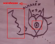
When I first laid my eyes on the map that I posted, the first things that I noticed were:
The Heart, the Omega Sign, the circles with the dots in them, the crosses, the river and Santa Fe.
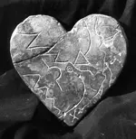
They are only a few symbols but enough to take notice of and compare with the "stone tablets".
The symbology or symbolism is the same. It seems too obvious to ignore.
Was the original map that produced the making of the "stone tablets" a similar map to the one that I posted?
Was it the same map maker? I could be wrong, but I don't think so.
But it very well could have been his apprentice.

Just a thought that has bothered me.
Could Willie D have also have had possession of the original map that was later made into the "stone tablets"?
After being tortured to a point of having to give something up why not give something up that was too hard to figure out?
Also it was not important to him at the time. It would keep the cowboys busy.
This does make sense and the symbolism on both maps are the same. And the time-line works.

Could Willie D be the cause of these maps finding their way into an unusual part of history?:cat:
 

Hard to say. The map includes some, but not all of the features which are shown on the Stone Heart.
To me, the three crosses say Jesuit, but others may see this differently. The two points may be prominent peaks, between which the heart can be found, or they may be two high points with the same inference. The inverse "omega" does appear not as such on the HS, where instead it is on a slant, and the circle dot is a circle in circle on the HS. It does show what appears to be a pathway or trail passing through the triangle formed by the extended lines of the heart. This may have the same meaning as the path from the "1" on the Upper Trail Stone, which ends at the triangle on the HS.

codice folio 9.png.......BW Heart sm.png

Is the map showing the same place, using similar symbology ?
Or a different place ?
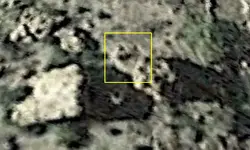
I believe so, and have seen a heart like that out there which I had previously rejected as important, because of the two pointed lobes and the fact that when seen from the opposite side of the canyon, it was upside down. But it is in an area I've been meaning to explore more thoroughly . It's also visible in sat views, despite the poor resolution of GE in the area, and about 5' x 7' in size. While I don't have much faith in GE imagery, I'll have to go check it out anyway, since it's on the map.

peaked heart at ruins.png
 

Last edited:
Not Peralta, that's a very interesting post (#327). Yes, there is clearly common symbology that may link the two map discoveries. This underscores the questions surrounding both discoveries' origins. The "Noss map" is obviously no older than 1861 (if that is a date of course), and possibly from the Noss era - 30's to the 40's. The "Peralta stones" seem to have surfaced in the '40's (no pun intended). The artwork seems very similarly executed. Keep digging.

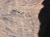
Somehiker, be cautious with the three crosses. As a map symbol, yes, it could represent a mark of possession I suppose, if such a notice would be necessary on a map (why would it?). If the symbol indicates something to find in the field, such as a carving, you'll find the three crosses in abundance in the Southwest. It represents Calvary to Hispanics and was carved everywhere they tended to gather in groups. This in itself is helpful as a trail marker, water source indicator and mine shrine locator. It could be a treasure map clue too, but you'll have to sort through a bunch to find the right one. Hey, good idea, actually.
lascruces.JPG
 

Last edited:

Top Member Reactions

Users who are viewing this thread

Back
Top